LiDAR 1m DTM Hillshade
Satellite Imagery
LiDAR 1m DTM Hillshade
Satellite Imagery
Scroll left/right to view further images.
HER: Scottish Borders 54654 (None)
NMR: NT 45 SW 6 (54654)
SM: 1171
NGR: NT 4190 5140
X: 341900 Y: 651400 (OSGB36)
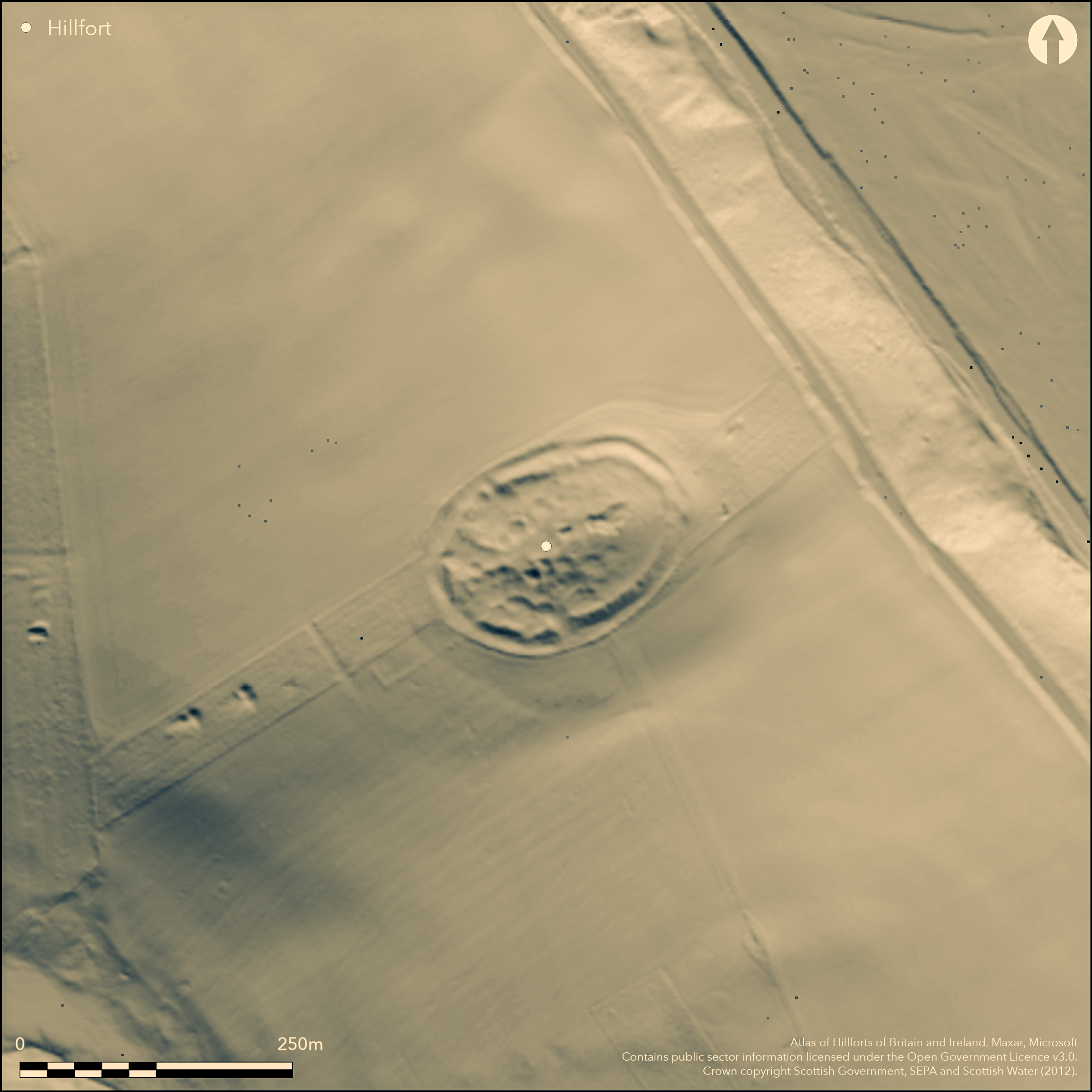
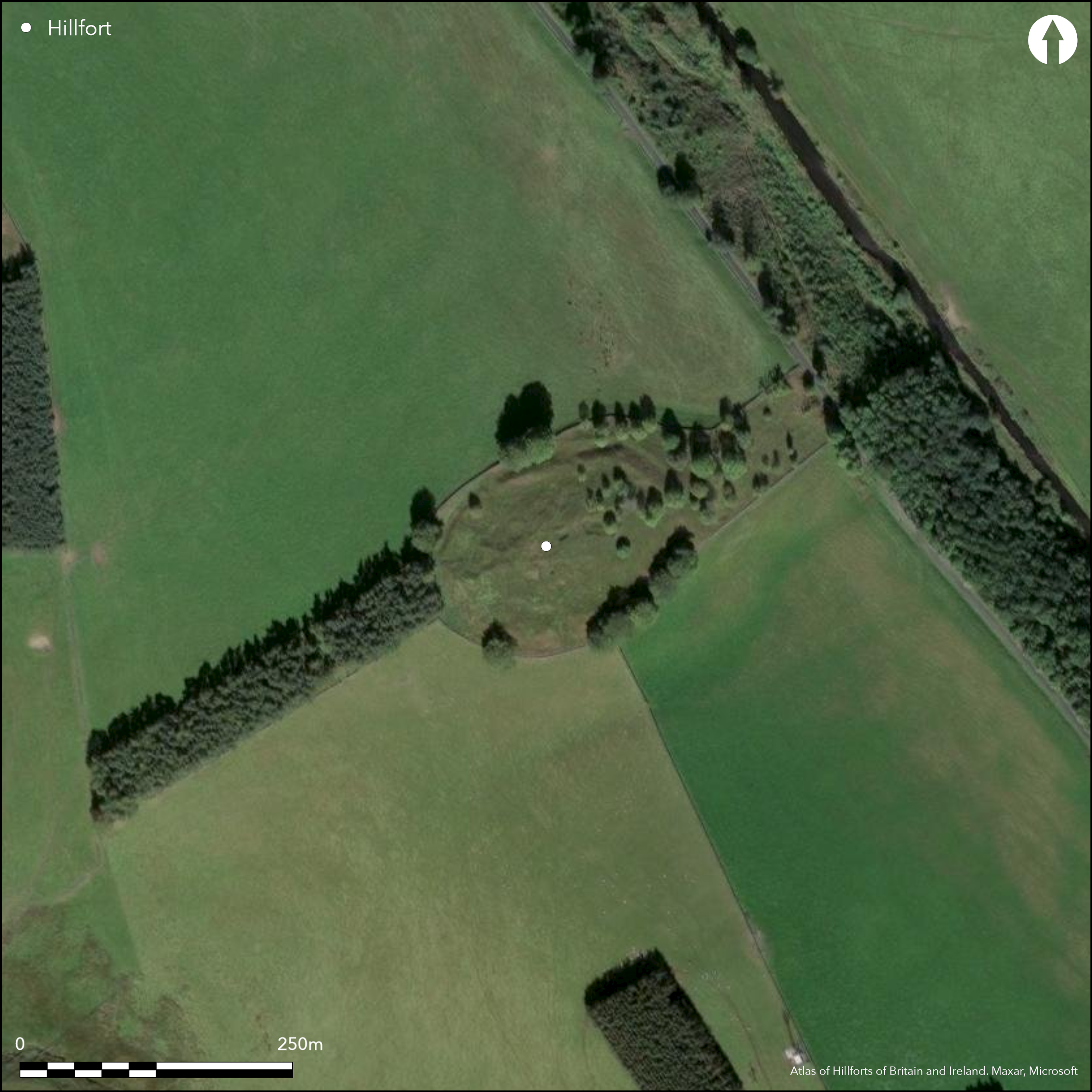
This fort occupies a steep-sided hillock on the SE spur of White Hill, which forms a ridge separating the valley of the Brockhouse Burn on the SW from the Gala Water on the NE. Contained largely within a stone plantation dyke, the fort is now free of trees, which were evidently planted over a rash of small quarry-pits which pockmark the whole of the interior and the defences. Apart from these, the oval interior is featureless and measures about 110m from ENE to WSW by 76m transversely (0.69ha) within twin ramparts with a broad medial ditch; where best preserved on the N the inner rampart stands 1.2m high internally and 4.5m above the bottom of the ditch. In addition to these defences within the plantation wall, Getmapping satellite imagery (2015) indicates a possible ploughed-out outer ditch on the SW, mounting the slope out of a natural gully that flanks SE side of the fort, and presumably extending round the easiest line of approach across the spur from the NW. Aerial photography also shows several gaps in the ramparts, but most are probably the result of quarrying and the only one that appears to be original is accompanied by a causeway across the ditch on the E.
Citizen Science: ✗
Reliability of Data: Confirmed
Reliability of Interpretation: Confirmed
X: -325858 Y: 7509303 (EPSG: 3857)
Longitude: -2.927228170717536 Latitude: 55.75250286601822 (EPSG:4326)
Country: Scotland
Current County or Unitary Authority: Scottish Borders
Historic County: Midlothian
Current Parish/Community/Council/Townland: Stow
None
| Extant | ✓ |
| Cropmark | ✗ |
| Likely Destroyed | ✗ |
Planted with mixed woodland in the early 19th century but now cleared
| Woodland | ✗ |
| Commercial Forestry Plantation | ✗ |
| Parkland | ✗ |
| Pasture (Grazing) | ✗ |
| Arable | ✗ |
| Scrub/Bracken | ✗ |
| Bare Outcrop | ✗ |
| Heather/Moorland | ✓ |
| Heath | ✗ |
| Built-up | ✗ |
| Coastal Grassland | ✗ |
| Other | ✗ |
None
| Contour Fort | ✓ |
| Partial Contour Fort | ✗ |
| Promontory Fort | ✗ |
| Hillslope Fort | ✗ |
| Level Terrain Fort | ✗ |
| Marsh Fort | ✗ |
| Multiple Enclosure Fort | ✗ |
| Hilltop | ✗ |
| Coastal Promontory | ✗ |
| Inland Promontory | ✗ |
| Valley Bottom | ✗ |
| Knoll/Hillock/Outcrop | ✓ |
| Ridge | ✗ |
| Cliff/Plateau-edge/Scarp | ✗ |
| Hillslope | ✗ |
| Lowland | ✗ |
| Spur | ✗ |
Dominant Topographic Feature: None
| North | ✗ |
| Northeast | ✗ |
| East | ✗ |
| Southeast | ✗ |
| South | ✗ |
| Southwest | ✗ |
| West | ✗ |
| Northwest | ✗ |
| Level | ✓ |
Altitude: 292.0m
N/A
In the absence of excavation, there are neither stratified artefacts nor radiocarbon dates to provide a chronology for the defences.
Reliability: D - None
| Pre 1200BC | ✗ |
| 1200BC - 800BC | ✗ |
| 800BC - 400BC | ✗ |
| 400BC - AD50 | ✗ |
| AD50 - AD400 | ✗ |
| AD400 - AD 800 | ✗ |
| Post AD800 | ✗ |
| Unknown | ✓ |
| Pre Hillfort: | None |
| Post Hillfort: | Heavily quarried and planted with trees in the early 19th century |
Photographed by Mike Brooks of Historic Scotland in 1980, and by John Dent in 1991, and the RCAHMS Aerial Survey Programme in 1981, 1989, 1993, 2007, 2008 and 2009
| 1st Identified Map Depiction (1773): | Concentric ring on a hill symbol on Mostyn Armstrong's Map of the three Lothians (1773) |
| Other (1821): | Annotated Old Camp on John Thomson's map of Edinburgh Shire (1821) |
| Other (1853): | Annotated Camp on the 1st edition OS 6-inch map (Edinburghshire 1854, sheet 23) |
| Other (1894): | Description by David Christison, base upon a visit by James Wilson (Christison 1895, 119-20) |
| Other (1913): | Description (RCAHMS 1929, 170, no.235 ) |
| Other (1935): | Scheduled |
| Other (1954): | Visited during the RCAHMS Survey of Marginal Lands (Feachem 1963, ) |
| Other (1965): | Resurveyed at 1:2500 by the OS |
| Other (1975): | Visited by the OS |
Pockmarked with later quarry-pits
None
| None | ✓ |
| Spring | ✗ |
| Stream | ✗ |
| Pool | ✗ |
| Flush | ✗ |
| Well | ✗ |
| Other | ✗ |
None
| No Known Features | ✓ |
| Round Stone Structures | ✗ |
| Rectangular Stone Structures | ✗ |
| Curvilinear Platforms | ✗ |
| Other Roundhouse Evidence | ✗ |
| Pits | ✗ |
| Quarry Hollows | ✗ |
| Other | ✗ |
None
| No Known Excavation | ✓ |
| Pits | ✗ |
| Postholes | ✗ |
| Roundhouses | ✗ |
| Rectangular Structures | ✗ |
| Roads/Tracks | ✗ |
| Quarry Hollows | ✗ |
| Other | ✗ |
| Nothing Found | ✗ |
None
| No Known Geophysics | ✓ |
| Pits | ✗ |
| Roundhouses | ✗ |
| Rectangular Structures | ✗ |
| Roads/Tracks | ✗ |
| Quarry Hollows | ✗ |
| Other | ✗ |
| Nothing Found | ✗ |
None
| No Known Finds | ✓ |
| Pottery | ✗ |
| Metal | ✗ |
| Metalworking | ✗ |
| Human Bones | ✗ |
| Animal Bones | ✗ |
| Lithics | ✗ |
| Environmental | ✗ |
| Other | ✗ |
NO APPARENT FEATURES
| APs Not Checked | ✗ |
| None | ✓ |
| Roundhouses | ✗ |
| Rectangular Structures | ✗ |
| Pits | ✗ |
| Postholes | ✗ |
| Roads/Tracks | ✗ |
| Other | ✗ |
See main summary
| 4: | None |
| 2: | None |
Guard Chambers: ✗
Chevaux de Frise: ✗
| 1. Simple Gap (East): | None |
Twin ramparts with a medial ditch, but possibly accompanied by an outer ditch on the NW
| Area 1: | 0.69ha. |
| Total: | 0.69ha. |
Total Footprint Area: 1.2ha.
None
| ✗ | This measurement of the overall footprint omits the possible outer ditch on the SW |
| ✓ | None |
| NE Quadrant: | 2 |
| SE Quadrant: | 2 |
| SW Quadrant: | 2 |
| NW Quadrant: | 2 |
| Total: | 2 |
| Partial Univallate | ✗ |
| Univallate | ✗ |
| Partial Bivallate | ✗ |
| Bivallate | ✓ |
| Partial Multivallate | ✗ |
| Multivallate | ✗ |
| Unknown | ✗ |
| Partial Univallate | ✗ |
| Univallate | ✗ |
| Partial Bivallate | ✗ |
| Bivallate | ✗ |
| Partial Multivallate | ✗ |
| Multivallate | ✗ |
None
| None | ✗ |
| Earthen Bank | ✓ |
| Stone Wall | ✗ |
| Rubble | ✗ |
| Wall-walk | ✗ |
| Evidence of Timber | ✗ |
| Vitrification | ✗ |
| Other Burning | ✗ |
| Palisade | ✗ |
| Counter Scarp Bank | ✗ |
| Berm | ✗ |
| Unfinished | ✗ |
| Other | ✗ |
None
| None | ✗ |
| Earthen Bank | ✗ |
| Stone Wall | ✗ |
| Murus Duplex | ✗ |
| Timber-framed | ✗ |
| Timber-laced | ✗ |
| Vitrification | ✗ |
| Other Burning | ✗ |
| Palisade | ✗ |
| Counter Scarp Bank | ✗ |
| Berm | ✗ |
| Unfinished | ✗ |
| No Known Excavation | ✓ |
| Other | ✗ |
| ✗ | None |
| ✗ | There is possibly a second ditch on the most easily accessible side |
Number of Ditches: 1
| ✗ | None |
Christison, D (1895) 'The forts of Selkirk, the Gala Water, the Southern slopes of the Lammermoors, and the north of Roxburgh'. Proc Soc Antiq Scot 29 (1894-50), 108-79
Feachem, R (1963) A guide to prehistoric Scotland. Batsford: London
RCAHMS (1929) The Royal Commission on the Ancient and Historical Monuments and Constructions of Scotland. Tenth report with Inventory of Monuments and Constructions in the Counties of Midlothian and West Lothian. HMSO: Edinburgh
Atlas of Hillforts:
Wikidata:
This work is licensed under CC BY-SA 4.0![]()
![]()
![]() and should be cited as:
and should be cited as:
Lock, Gary and Ralston, Ian. 2024. Atlas of Hillforts of Britain and Ireland. Available at: https://hillforts.arch.ox.ac.uk
Document Version 1.1