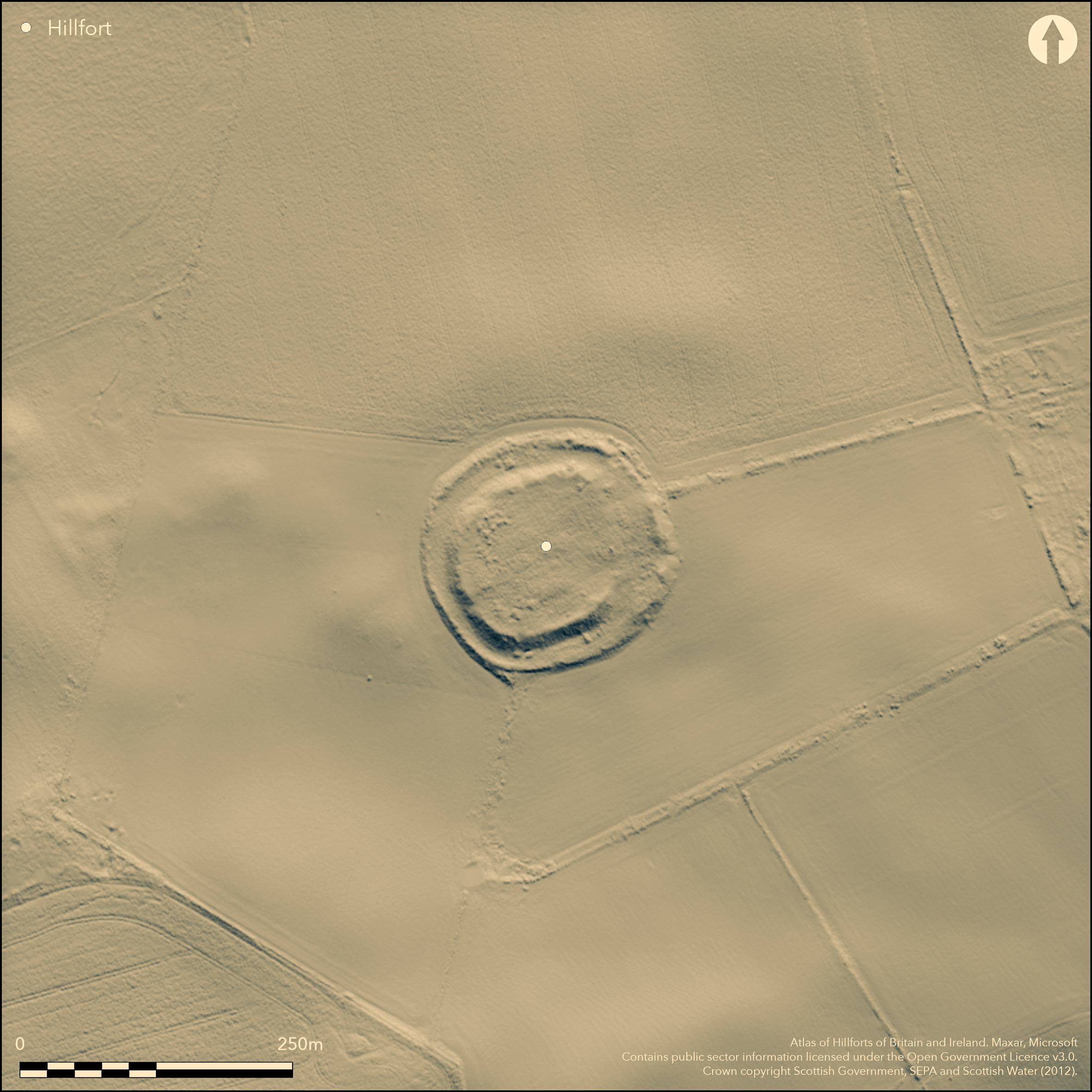
LiDAR 1m DTM Hillshade

Satellite Imagery
LiDAR 1m DTM Hillshade
Satellite Imagery
Scroll left/right to view further images.
HER: Midlothian per East Lothian Council MEL8571 (None)
NMR: NT 46 SW 10 (54796)
SM: 1174
NGR: NT 4038 6176
X: 340380 Y: 661760 (OSGB36)
This fort occupies a low hillock which had been incorporated into a roundel in the designed landscape around Longfaugh by the mid 18th century. Oval on plan, it measures about 88m from NE to SW by 75m transversely (0.5ha) within twin ramparts with a broad medial ditch. Both ramparts have been mutilated at various points around the circuit, the outer overlain by the plantation boundary, but where best preserved the inner still stands 1.5m high internally and up to 4.5m externally above the bottom of the ditch. The entrance was probably on the E, where a large sector of the inner rampart has been largely levelled, but the purpose of another bank between the two ramparts on the S side of this gap is unknown. The interior is featureless.
Citizen Science: ✗
Reliability of Data: Confirmed
Reliability of Interpretation: Confirmed
X: -328806 Y: 7527699 (EPSG: 3857)
Longitude: -2.953713858704311 Latitude: 55.84539116684037 (EPSG:4326)
Country: Scotland
Current County or Unitary Authority: Midlothian
Historic County: Midlothian
Current Parish/Community/Council/Townland: Crichton
None
| Extant | ✓ |
| Cropmark | ✗ |
| Likely Destroyed | ✗ |
None
| Woodland | ✓ |
| Commercial Forestry Plantation | ✗ |
| Parkland | ✓ |
| Pasture (Grazing) | ✓ |
| Arable | ✗ |
| Scrub/Bracken | ✓ |
| Bare Outcrop | ✗ |
| Heather/Moorland | ✗ |
| Heath | ✗ |
| Built-up | ✗ |
| Coastal Grassland | ✗ |
| Other | ✗ |
None
| Contour Fort | ✓ |
| Partial Contour Fort | ✗ |
| Promontory Fort | ✗ |
| Hillslope Fort | ✗ |
| Level Terrain Fort | ✗ |
| Marsh Fort | ✗ |
| Multiple Enclosure Fort | ✗ |
| Hilltop | ✗ |
| Coastal Promontory | ✗ |
| Inland Promontory | ✗ |
| Valley Bottom | ✗ |
| Knoll/Hillock/Outcrop | ✓ |
| Ridge | ✗ |
| Cliff/Plateau-edge/Scarp | ✗ |
| Hillslope | ✗ |
| Lowland | ✗ |
| Spur | ✗ |
Dominant Topographic Feature: None
| North | ✗ |
| Northeast | ✗ |
| East | ✗ |
| Southeast | ✗ |
| South | ✗ |
| Southwest | ✗ |
| West | ✗ |
| Northwest | ✗ |
| Level | ✓ |
Altitude: 245.0m
N/A
In the absence of excavation, there are neither stratified artefacts nor radiocarbon dates to provide a chronology for the defences.
Reliability: D - None
| Pre 1200BC | ✗ |
| 1200BC - 800BC | ✗ |
| 800BC - 400BC | ✗ |
| 400BC - AD50 | ✗ |
| AD50 - AD400 | ✗ |
| AD400 - AD 800 | ✗ |
| Post AD800 | ✗ |
| Unknown | ✓ |
| Pre Hillfort: | None |
| Post Hillfort: | A possible hoard of Roman coins supposedly found here, but the association is not particularly secure; by 1755 it had been incorporated into a roundel in the design of the landscape around Lonfaugh. |
In 1785 twelve Roman coins, possibly a Constantinian hoard, and supposedly found in a 'Roman encampment on the estate of Crichton-dean', were associated by Sir George Macdonald with the area around the fort at Longfaugh (Macdonald 1918, 212), but cropmarks have now revealed other prehistoric enclosures in this area and the association is by no means secure. Chrghtondean is shown to the NE of Longfaugh on Mostyn Armstrong's Map of the three Lothians (1773), which depicts an ancient camp nearby on Marr Law, though across the county boundary this may have been on a neighbouring estate, but cropmarks have also revealed a prehistoric settlement in a roundel between Chrightondean and Longfaugh.
| Other (1755): | Evidently recognised and taken into a roundel in the emparking shown on William Roy's Military Map of Scotland (1747-55) |
| Other (1773): | Roundel shown on Mostyn Armstrong's Map of the three Lothians (1773) |
| 1st Identified Map Depiction (1821): | Annotated Roman Camp on John Thomson's map of Edinburgh Shire (1821) |
| Other (1853): | Annotated Fort on the 1st edition OS 6-inch map (Edinburghshire 1854, sheet 14) |
| Other (1892): | Annotated Fort on the OS 25-inch map (Edinburghshire 1894, sheet 15.2) |
| Earthwork Survey (1913): | Plan and description (RCAHMS 1929, 52, no.60, fig 76; RCAHMS MLD 53/1-2) |
| Other (1924): | Scheduled |
| Other (1955): | Visited during the RCAHMS Survey of Marginal Lands (Feachem 1963, 137) |
| Other (1975): | Visited by the OS |
| Other (1978): | Re-Scheduled |
Featureless
None
| None | ✓ |
| Spring | ✗ |
| Stream | ✗ |
| Pool | ✗ |
| Flush | ✗ |
| Well | ✗ |
| Other | ✗ |
None
| No Known Features | ✓ |
| Round Stone Structures | ✗ |
| Rectangular Stone Structures | ✗ |
| Curvilinear Platforms | ✗ |
| Other Roundhouse Evidence | ✗ |
| Pits | ✗ |
| Quarry Hollows | ✗ |
| Other | ✗ |
None
| No Known Excavation | ✓ |
| Pits | ✗ |
| Postholes | ✗ |
| Roundhouses | ✗ |
| Rectangular Structures | ✗ |
| Roads/Tracks | ✗ |
| Quarry Hollows | ✗ |
| Other | ✗ |
| Nothing Found | ✗ |
None
| No Known Geophysics | ✓ |
| Pits | ✗ |
| Roundhouses | ✗ |
| Rectangular Structures | ✗ |
| Roads/Tracks | ✗ |
| Quarry Hollows | ✗ |
| Other | ✗ |
| Nothing Found | ✗ |
None
| No Known Finds | ✓ |
| Pottery | ✗ |
| Metal | ✗ |
| Metalworking | ✗ |
| Human Bones | ✗ |
| Animal Bones | ✗ |
| Lithics | ✗ |
| Environmental | ✗ |
| Other | ✗ |
NO APPARENT FEATURES
| APs Not Checked | ✗ |
| None | ✓ |
| Roundhouses | ✗ |
| Rectangular Structures | ✗ |
| Pits | ✗ |
| Postholes | ✗ |
| Roads/Tracks | ✗ |
| Other | ✗ |
See main summary
| 1: | None |
| 2: | None |
Guard Chambers: ✗
Chevaux de Frise: ✗
| 1. Simple Gap (East): | Possible entrance |
Twin ramparts with a medial ditch
| Area 1: | 0.5ha. |
| Total: | 0.5ha. |
Total Footprint Area: 1.3ha.
None
| ✗ | None |
| ✓ | None |
| NE Quadrant: | 2 |
| SE Quadrant: | 2 |
| SW Quadrant: | 2 |
| NW Quadrant: | 2 |
| Total: | 2 |
| Partial Univallate | ✗ |
| Univallate | ✗ |
| Partial Bivallate | ✗ |
| Bivallate | ✓ |
| Partial Multivallate | ✗ |
| Multivallate | ✗ |
| Unknown | ✗ |
| Partial Univallate | ✗ |
| Univallate | ✗ |
| Partial Bivallate | ✗ |
| Bivallate | ✗ |
| Partial Multivallate | ✗ |
| Multivallate | ✗ |
None
| None | ✗ |
| Earthen Bank | ✓ |
| Stone Wall | ✗ |
| Rubble | ✗ |
| Wall-walk | ✗ |
| Evidence of Timber | ✗ |
| Vitrification | ✗ |
| Other Burning | ✗ |
| Palisade | ✗ |
| Counter Scarp Bank | ✗ |
| Berm | ✗ |
| Unfinished | ✗ |
| Other | ✗ |
None
| None | ✗ |
| Earthen Bank | ✗ |
| Stone Wall | ✗ |
| Murus Duplex | ✗ |
| Timber-framed | ✗ |
| Timber-laced | ✗ |
| Vitrification | ✗ |
| Other Burning | ✗ |
| Palisade | ✗ |
| Counter Scarp Bank | ✗ |
| Berm | ✗ |
| Unfinished | ✗ |
| No Known Excavation | ✓ |
| Other | ✗ |
| ✗ | None |
| ✓ | None |
Number of Ditches: 1
| ✗ | None |
Feachem, R (1963) A guide to prehistoric Scotland. Batsford: London
Macdonald, G (1918) 'Roman coins found in Scotland'. Proc Soc Antiq Scot 52 (1917-18), 203-76
RCAHMS (1929) The Royal Commission on the Ancient and Historical Monuments and Constructions of Scotland. Tenth report with Inventory of Monuments and Constructions in the Counties of Midlothian and West Lothian. HMSO: Edinburgh
Atlas of Hillforts:
Wikidata:
This work is licensed under CC BY-SA 4.0![]()
![]()
![]() and should be cited as:
and should be cited as:
Lock, Gary and Ralston, Ian. 2024. Atlas of Hillforts of Britain and Ireland. Available at: https://hillforts.arch.ox.ac.uk
Document Version 1.1