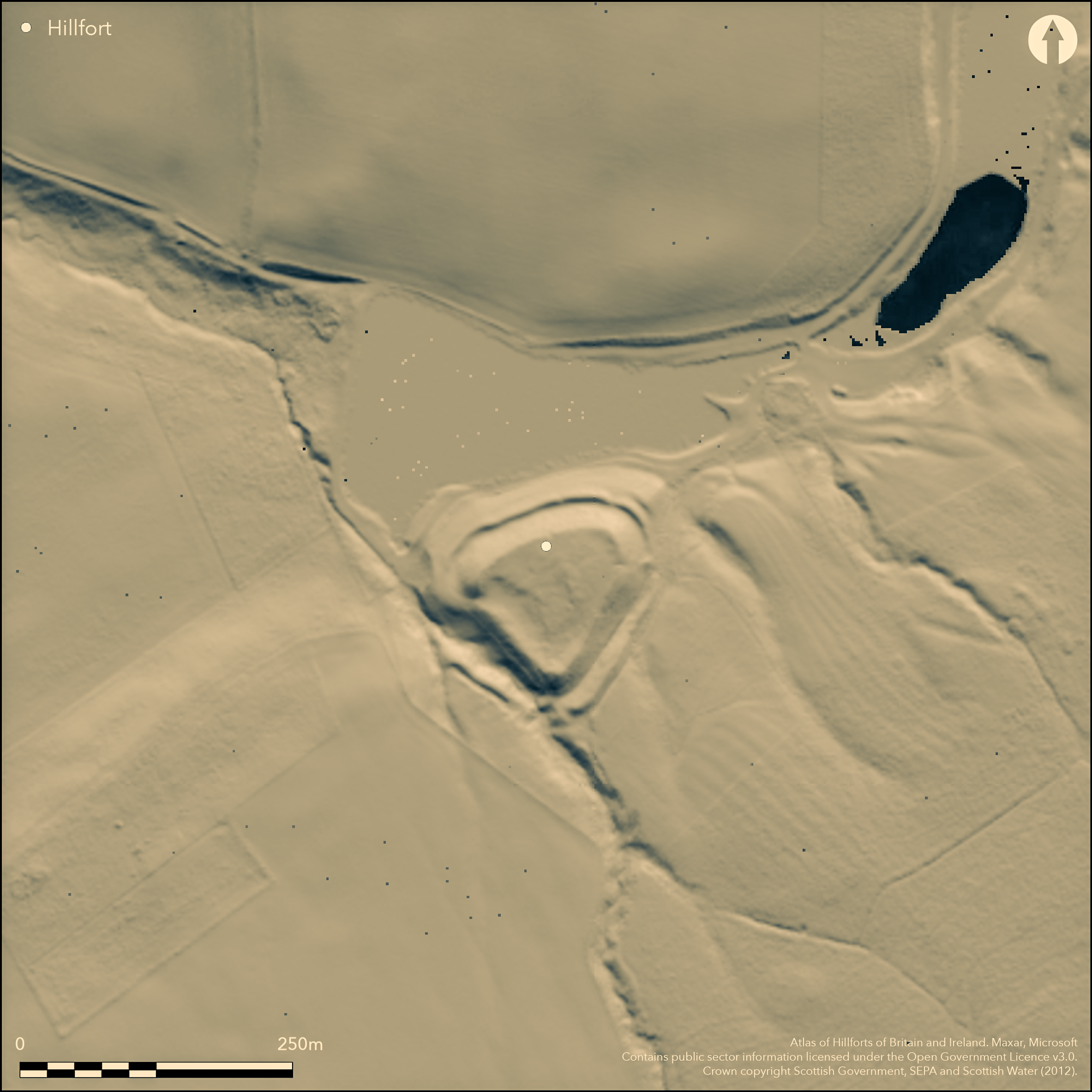
LiDAR 1m DTM Hillshade
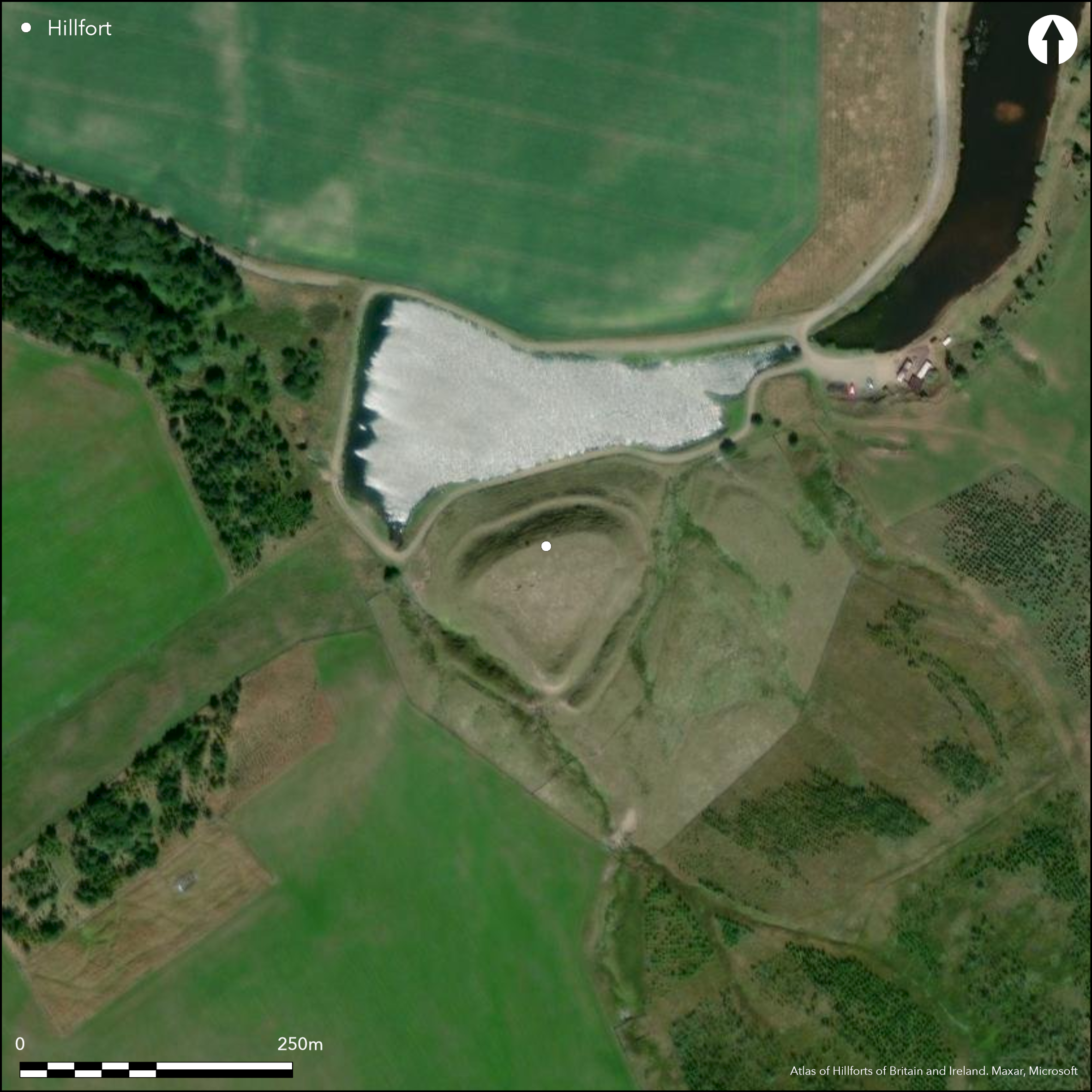
Satellite Imagery
LiDAR 1m DTM Hillshade
Satellite Imagery
Scroll left/right to view further images.
HER: East Lothian Council MEL685 (None)
NMR: NT 56 NE 3 (56084)
SM: 747
NGR: NT 5818 6569
X: 358180 Y: 665690 (OSGB36)
This fortification occupies a promontory that has been isolated by natural gullies to form a steep-sided hillock. Roughly triangular on plan, it measures 68m from NE to SW by 58m transversely (0.3ha) within the inner rampart, though for much of the circuit this has been reduced to little more than a raised lip. Partly exploiting a natural gully on the SE, the rampart is also accompanied by a massive external ditch, which has been sunk some 6m below the level of the interior on the SE, and carried around the NE end and along the N flank. An outer rampart has also been piled up along its counterscarp, and a second ditch has been dug along the SE flank from the NE end. On the SW, the deeply incised stream gully seems to replace the inner ditch, and the outer bank and ditch have been continued along the lip of the escarpment forming its far side of the gully. The entrance is on the W, approached from the N by a trackway which mounts the slope between the end of the outer rampart and the burn and turns in between the terminals of the inner rampart at the NW end of the SW side. Traces of a rectangular structure are visible within the interior. The character of the defences is unusual and shares more in common with medieval earthwork castles than Iron Age forts.
Citizen Science: ✗
Reliability of Data: Confirmed
Reliability of Interpretation: Confirmed
X: -297231 Y: 7535075 (EPSG: 3857)
Longitude: -2.6700757493759717 Latitude: 55.8825747378007 (EPSG:4326)
Country: Scotland
Current County or Unitary Authority: East Lothian
Historic County: East Lothian
Current Parish/Community/Council/Townland: Garvald And Bara
None
| Extant | ✓ |
| Cropmark | ✗ |
| Likely Destroyed | ✗ |
None
| Woodland | ✗ |
| Commercial Forestry Plantation | ✗ |
| Parkland | ✗ |
| Pasture (Grazing) | ✓ |
| Arable | ✗ |
| Scrub/Bracken | ✗ |
| Bare Outcrop | ✗ |
| Heather/Moorland | ✓ |
| Heath | ✗ |
| Built-up | ✗ |
| Coastal Grassland | ✗ |
| Other | ✗ |
None
| Contour Fort | ✓ |
| Partial Contour Fort | ✗ |
| Promontory Fort | ✗ |
| Hillslope Fort | ✗ |
| Level Terrain Fort | ✗ |
| Marsh Fort | ✗ |
| Multiple Enclosure Fort | ✗ |
| Hilltop | ✗ |
| Coastal Promontory | ✗ |
| Inland Promontory | ✓ |
| Valley Bottom | ✗ |
| Knoll/Hillock/Outcrop | ✗ |
| Ridge | ✗ |
| Cliff/Plateau-edge/Scarp | ✗ |
| Hillslope | ✗ |
| Lowland | ✗ |
| Spur | ✗ |
Dominant Topographic Feature: None
| North | ✗ |
| Northeast | ✗ |
| East | ✗ |
| Southeast | ✗ |
| South | ✗ |
| Southwest | ✗ |
| West | ✗ |
| Northwest | ✗ |
| Level | ✓ |
Altitude: 290.0m
N/A
In the absence of excavation, there are neither stratified artefacts nor radiocarbon dates to provide a chronology for the defences.
Reliability: D - None
| Pre 1200BC | ✗ |
| 1200BC - 800BC | ✗ |
| 800BC - 400BC | ✗ |
| 400BC - AD50 | ✗ |
| AD50 - AD400 | ✗ |
| AD400 - AD 800 | ✗ |
| Post AD800 | ✗ |
| Unknown | ✓ |
| Pre Hillfort: | None |
| Post Hillfort: | Planted with trees, probably since 1773 |
Photographed by CUCAP in 1953, and RCAHMS Aerial Survey Programme in 1982, 1983, 1988, 2008 and 2010
| 1st Identified Map Depiction (1773): | Concentric ring symbol on Andrew and Mostyn Armstrong's Map of the three Lothians (1773) |
| 1st Identified Written Reference (1794): | Noted (Stat Acct, xiii, 1794. 362n) |
| Other (1853): | Annotated Fort on the 1st edition OS 6-inch map (Haddingtonshire 1855, sheet 15) |
| Other (1892): | Depicted on the OS 25-inch map (Haddingtonshire 1894, sheet 16.9) |
| Earthwork Survey (1913): | Plan and description (RCAHMS 1924, 32-3, no.46, fig 67; RCAHMS ELD 76/2V & ELD 12/1-4) |
| Other (1923): | Scheduled |
| Other (1954): | Description during RCAHMS Survey of Marginal Lands (Feachem 1963, 123) |
| Other (1965): | Resurveyed at 1:2500 by the OS |
| Other (1969): | Re-Scheduled |
| Other (1979): | Visited by the OS |
Traces of a rectangular structure can be seen within the interior.
None
| None | ✓ |
| Spring | ✗ |
| Stream | ✗ |
| Pool | ✗ |
| Flush | ✗ |
| Well | ✗ |
| Other | ✗ |
None
| No Known Features | ✓ |
| Round Stone Structures | ✗ |
| Rectangular Stone Structures | ✗ |
| Curvilinear Platforms | ✗ |
| Other Roundhouse Evidence | ✗ |
| Pits | ✗ |
| Quarry Hollows | ✗ |
| Other | ✗ |
None
| No Known Excavation | ✓ |
| Pits | ✗ |
| Postholes | ✗ |
| Roundhouses | ✗ |
| Rectangular Structures | ✗ |
| Roads/Tracks | ✗ |
| Quarry Hollows | ✗ |
| Other | ✗ |
| Nothing Found | ✗ |
None
| No Known Geophysics | ✓ |
| Pits | ✗ |
| Roundhouses | ✗ |
| Rectangular Structures | ✗ |
| Roads/Tracks | ✗ |
| Quarry Hollows | ✗ |
| Other | ✗ |
| Nothing Found | ✗ |
None
| No Known Finds | ✓ |
| Pottery | ✗ |
| Metal | ✗ |
| Metalworking | ✗ |
| Human Bones | ✗ |
| Animal Bones | ✗ |
| Lithics | ✗ |
| Environmental | ✗ |
| Other | ✗ |
NO APPARENT FEATURES
| APs Not Checked | ✗ |
| None | ✓ |
| Roundhouses | ✗ |
| Rectangular Structures | ✗ |
| Pits | ✗ |
| Postholes | ✗ |
| Roads/Tracks | ✗ |
| Other | ✗ |
See main summary
| 1: | None |
| 2: | None |
Guard Chambers: ✗
Chevaux de Frise: ✗
| 1. Simple Gap (West): | None |
Two ramparts with a medial ditch, with an additional ditch on two sides
| Area 1: | 0.3ha. |
| Total: | 0.3ha. |
Total Footprint Area: 1.1ha.
None
| ✗ | None |
| ✓ | None |
| NE Quadrant: | 2 |
| SE Quadrant: | 2 |
| SW Quadrant: | 1 |
| NW Quadrant: | 2 |
| Total: | 2 |
| Partial Univallate | ✓ |
| Univallate | ✗ |
| Partial Bivallate | ✓ |
| Bivallate | ✗ |
| Partial Multivallate | ✗ |
| Multivallate | ✗ |
| Unknown | ✗ |
| Partial Univallate | ✗ |
| Univallate | ✗ |
| Partial Bivallate | ✗ |
| Bivallate | ✗ |
| Partial Multivallate | ✗ |
| Multivallate | ✗ |
None
| None | ✗ |
| Earthen Bank | ✓ |
| Stone Wall | ✗ |
| Rubble | ✗ |
| Wall-walk | ✗ |
| Evidence of Timber | ✗ |
| Vitrification | ✗ |
| Other Burning | ✗ |
| Palisade | ✗ |
| Counter Scarp Bank | ✗ |
| Berm | ✗ |
| Unfinished | ✗ |
| Other | ✗ |
None
| None | ✗ |
| Earthen Bank | ✗ |
| Stone Wall | ✗ |
| Murus Duplex | ✗ |
| Timber-framed | ✗ |
| Timber-laced | ✗ |
| Vitrification | ✗ |
| Other Burning | ✗ |
| Palisade | ✗ |
| Counter Scarp Bank | ✗ |
| Berm | ✗ |
| Unfinished | ✗ |
| No Known Excavation | ✓ |
| Other | ✗ |
| ✗ | None |
| ✓ | a second ditch on two sides |
Number of Ditches: 2
| ✗ | None |
Feachem, R W (1963) A guide to prehistoric Scotland. Batsford: London
RCAHMS (1924) The Royal Commission on the Ancient and Historical Monuments and Constructions of Scotland. Eighth report with Inventory of Monuments and Constructions in the County of East Lothian. HMSO: Edinburgh
Atlas of Hillforts:
Wikidata:
This work is licensed under CC BY-SA 4.0![]()
![]()
![]() and should be cited as:
and should be cited as:
Lock, Gary and Ralston, Ian. 2024. Atlas of Hillforts of Britain and Ireland. Available at: https://hillforts.arch.ox.ac.uk
Document Version 1.1