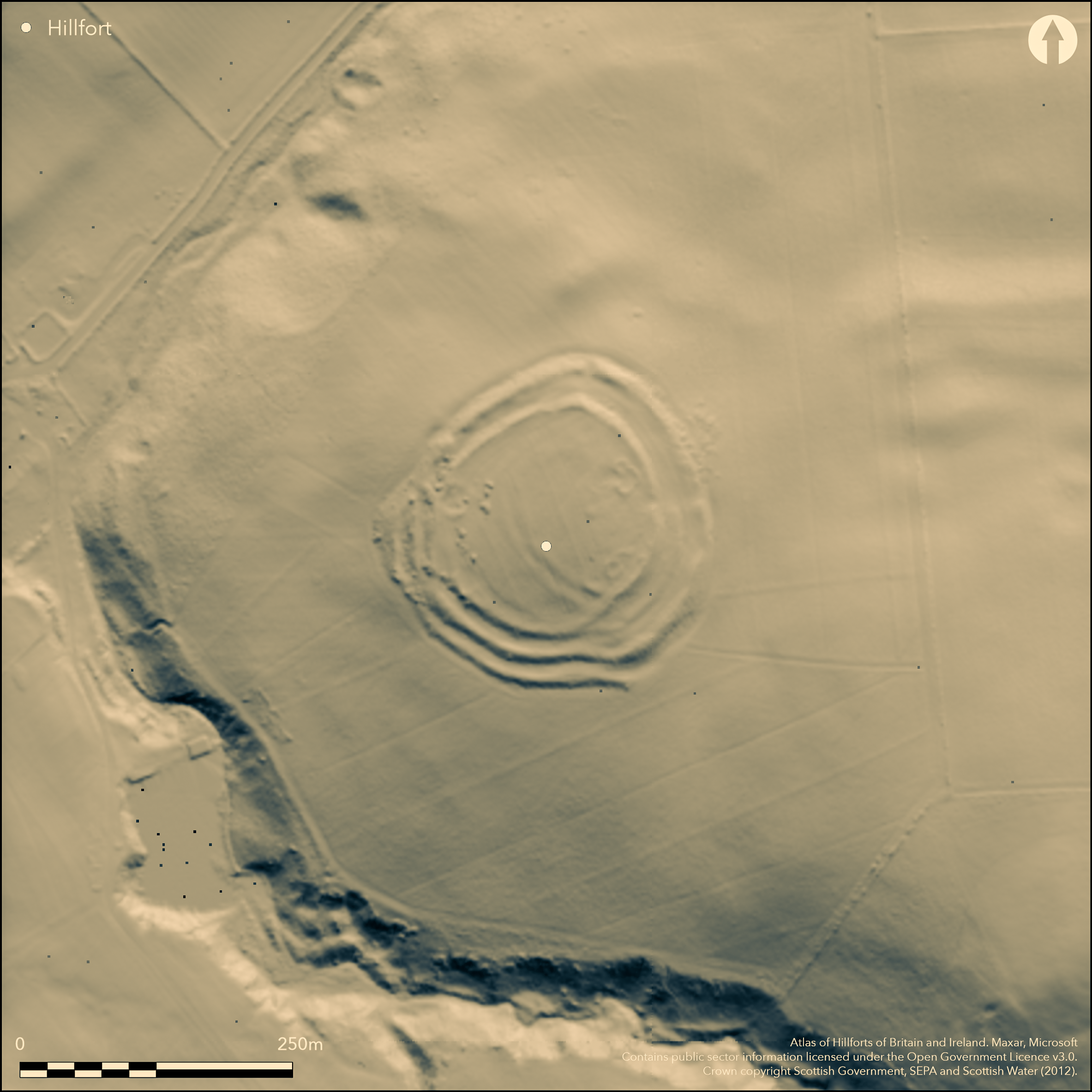
LiDAR 1m DTM Hillshade
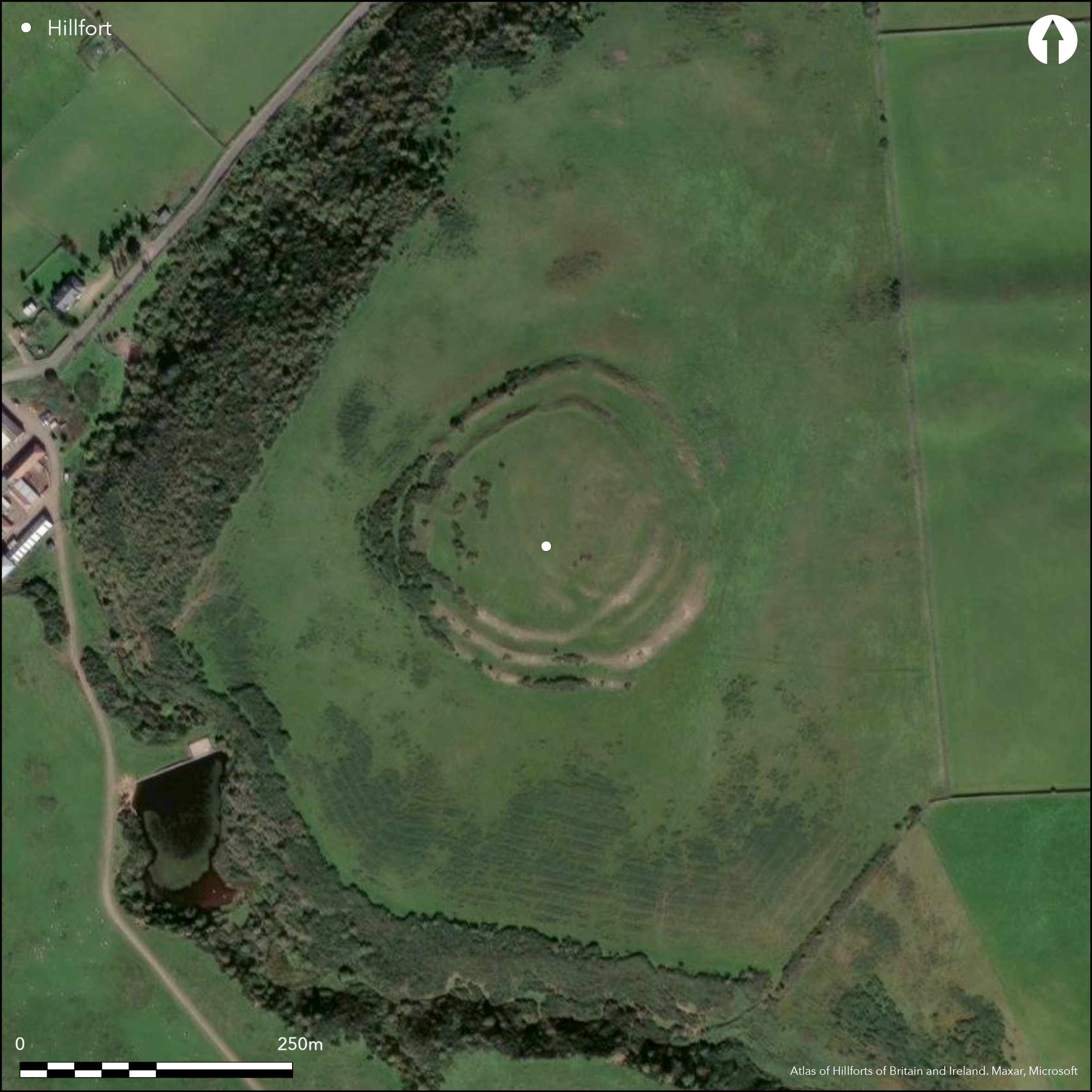
Satellite Imagery
LiDAR 1m DTM Hillshade
Satellite Imagery
Scroll left/right to view further images.
HER: East Lothian Council MEL785 (None)
NMR: NT 56 SW 1 (56184)
SM: 753
NGR: NT 5126 6418
X: 351260 Y: 664180 (OSGB36)
A complex fort stands on the hill above Kidlaw steading, occupying the hillock that forms the local summit at the NW end of the spur dropping down from Highside Hill. The defences of the fort display evidence of a complex evolution and several periods of remodelling, in the final phase comprising between two and three ramparts with external ditches enclosing a roughly circular area measuring about 114m from N to S by 110m transversely (0.9ha), with at least one entrance on the W and possibly a second on the E; the W entrance is notable for the staggered terminals of the inner rampart, which expose the visitor's right side, though this may in part be the result of the remodelling of earlier defences. Nevertheless, from this entrance round the SW quarter to a shallow re-entrant on the S, the defences comprise three ramparts with external ditches, while elsewhere there are only two visible, forming impressive external scarps with very little trace of the ditches that must have been dug into the slopes below them. The re-entrant, however, is a curious feature that suggests the realignment of earlier defences in this sector, perhaps including the blocking of an entrance, and it is probably no coincidence that what appears to be an earlier rampart reduced to a scarp can be traced on the ground between the two ramparts forming the SE sector of the latest fort as far as the E entrance. Projected westwards the arc of this earlier rampart appears to turn under the inner rampart and is picked up by a low scarp within the interior that might otherwise be interpreted as the rear of an internal quarry scoop, albeit one lying eccentrically to the inner rampart. Unfortunately the interior has been cultivated in shallow rigs in at least two directions, which has obscured several other earlier features, but traces of two more ramparts extend in an arc across its centre, enclosing the W side of the higher eastern half and clearly predating the inner rampart drawn around the E side; this earlier fort encloses an area measuring about 85m from N to S by 65m transversely (0.43ha). In addition a groove visible some 7m behind the inner rampart on the NW seems rather more substantial than the cultivation furrows and may be the remains of a palisade trench. While the full sequence here cannot be resolved without excavation, the final phase of occupation evidently post-dates the defences, comprising three small enclosures with stone-founded round-houses set on the margins of the interior on the ENE, ESE and WNW respectively, the last two incorporating the inner rampart into the perimeters of their yards.
Citizen Science: ✗
Reliability of Data: Confirmed
Reliability of Interpretation: Confirmed
X: -309514 Y: 7532254 (EPSG: 3857)
Longitude: -2.780412309599801 Latitude: 55.86835690599255 (EPSG:4326)
Country: Scotland
Current County or Unitary Authority: East Lothian
Historic County: East Lothian
Current Parish/Community/Council/Townland: Yester
None
| Extant | ✓ |
| Cropmark | ✗ |
| Likely Destroyed | ✗ |
None
| Woodland | ✗ |
| Commercial Forestry Plantation | ✗ |
| Parkland | ✗ |
| Pasture (Grazing) | ✓ |
| Arable | ✗ |
| Scrub/Bracken | ✗ |
| Bare Outcrop | ✗ |
| Heather/Moorland | ✓ |
| Heath | ✗ |
| Built-up | ✗ |
| Coastal Grassland | ✗ |
| Other | ✗ |
None
| Contour Fort | ✓ |
| Partial Contour Fort | ✗ |
| Promontory Fort | ✗ |
| Hillslope Fort | ✗ |
| Level Terrain Fort | ✗ |
| Marsh Fort | ✗ |
| Multiple Enclosure Fort | ✗ |
| Hilltop | ✓ |
| Coastal Promontory | ✗ |
| Inland Promontory | ✗ |
| Valley Bottom | ✗ |
| Knoll/Hillock/Outcrop | ✗ |
| Ridge | ✗ |
| Cliff/Plateau-edge/Scarp | ✗ |
| Hillslope | ✗ |
| Lowland | ✗ |
| Spur | ✗ |
Dominant Topographic Feature: None
| North | ✗ |
| Northeast | ✗ |
| East | ✗ |
| Southeast | ✗ |
| South | ✗ |
| Southwest | ✗ |
| West | ✗ |
| Northwest | ✗ |
| Level | ✓ |
Altitude: 279.0m
N/A
In the absence of excavation, there are neither stratified artefacts nor radiocarbon dates to provide a chronology for the defences.
Reliability: D - None
| Pre 1200BC | ✗ |
| 1200BC - 800BC | ✗ |
| 800BC - 400BC | ✗ |
| 400BC - AD50 | ✗ |
| AD50 - AD400 | ✗ |
| AD400 - AD 800 | ✗ |
| Post AD800 | ✗ |
| Unknown | ✓ |
| Pre Hillfort: | None |
| Post Hillfort: | Overlain by small late Iron Age settlements, and subsequently the interior was ploughed in the post-medieval period |
Photographed by CUCAP in 1953 and 1955, John Dewar in 1971 (held by RCAHMS), by Mike Brookes for Historic Scotland in 1979, and RCAHMS Aerial Survey Programme in 1980, 1983, 1988, 1991 and 2008. Visited on numerous occasions by S Halliday
| 1st Identified Map Depiction (1755): | Depicted on William Roy's Military Map of Scotland (1747-55) |
| Other (1773): | Concentric ring on a hill symbol on Andrew and Mostyn Armstrong's Map of the three Lothians (1773) and named Castle Hill |
| Earthwork Survey (1827): | Sketch-plan and description by Wiliam Waring Hay (1831, 303) |
| Other (1853): | Annotated Fort on the 1st edition OS 6-inch map (Haddingtonshire 1855, sheet 15) |
| Other (1892): | Depicted on the OS 25-inch map (Haddingtonshire 1894, sheet 15.14) |
| Earthwork Survey (1913): | Plan and description (RCAHMS 1924, 153-4, no.259, fig 189; RCAHMS ELD 15/1-2) |
| Other (1923): | Scheduled |
| Earthwork Survey (1954): | Plan and description during RCAHMS Survey of Marginal Lands (RCAHMS ELD 15/3-4; Feachem 1963, 122) |
| Other (1961): | Re-Scheduled |
| Other (1975): | Visited by the OS |
| Other (1998): | Re-Scheduled |
Cultivated in shallow rigs but three small homesteads with stone-founded round-houses are disposed around the margins of the interior on the ENE, ESE and WNW respectively
None
| None | ✓ |
| Spring | ✗ |
| Stream | ✗ |
| Pool | ✗ |
| Flush | ✗ |
| Well | ✗ |
| Other | ✗ |
None
| No Known Features | ✗ |
| Round Stone Structures | ✓ |
| Rectangular Stone Structures | ✗ |
| Curvilinear Platforms | ✗ |
| Other Roundhouse Evidence | ✗ |
| Pits | ✗ |
| Quarry Hollows | ✗ |
| Other | ✗ |
None
| No Known Excavation | ✓ |
| Pits | ✗ |
| Postholes | ✗ |
| Roundhouses | ✗ |
| Rectangular Structures | ✗ |
| Roads/Tracks | ✗ |
| Quarry Hollows | ✗ |
| Other | ✗ |
| Nothing Found | ✗ |
None
| No Known Geophysics | ✓ |
| Pits | ✗ |
| Roundhouses | ✗ |
| Rectangular Structures | ✗ |
| Roads/Tracks | ✗ |
| Quarry Hollows | ✗ |
| Other | ✗ |
| Nothing Found | ✗ |
None
| No Known Finds | ✓ |
| Pottery | ✗ |
| Metal | ✗ |
| Metalworking | ✗ |
| Human Bones | ✗ |
| Animal Bones | ✗ |
| Lithics | ✗ |
| Environmental | ✗ |
| Other | ✗ |
Belonging to the Late-Iron Age homesteads
| APs Not Checked | ✗ |
| None | ✗ |
| Roundhouses | ✓ |
| Rectangular Structures | ✗ |
| Pits | ✗ |
| Postholes | ✗ |
| Roads/Tracks | ✗ |
| Other | ✗ |
See main summary
| 3: | None |
| 2: | None |
Guard Chambers: ✗
Chevaux de Frise: ✗
| 1. Simple Gap (East): | None |
| 2. Blocked (South): | Possible blocked entrance |
| 3. Oblique (West): | In its final phase the terminals of the inner rampart are staggered. Oblique approach exposing right side |
Up to three ramparts with external ditches in the final phase enclosure, but evidence of at least one earlier circuit within the interior, and possibly also a palisade trench
| Area 1: | 0.43ha. |
| Area 2: | 0.9ha. |
| Total: | 0.9ha. |
Total Footprint Area: 2.4ha.
None
| ✓ | Clear evidence not only of an earlier rampart cutting across the interior, but of an earlier rampart between the major lines of the final fort on the SE, and a possible blocked entrance on the S |
| ✓ | None |
| NE Quadrant: | 2 |
| SE Quadrant: | 3 |
| SW Quadrant: | 4 |
| NW Quadrant: | 3 |
| Total: | 4 |
| Partial Univallate | ✗ |
| Univallate | ✗ |
| Partial Bivallate | ✓ |
| Bivallate | ✗ |
| Partial Multivallate | ✓ |
| Multivallate | ✗ |
| Unknown | ✗ |
| Partial Univallate | ✗ |
| Univallate | ✗ |
| Partial Bivallate | ✓ |
| Bivallate | ✗ |
| Partial Multivallate | ✗ |
| Multivallate | ✗ |
None
| None | ✗ |
| Earthen Bank | ✓ |
| Stone Wall | ✗ |
| Rubble | ✗ |
| Wall-walk | ✗ |
| Evidence of Timber | ✗ |
| Vitrification | ✗ |
| Other Burning | ✗ |
| Palisade | ✓ |
| Counter Scarp Bank | ✗ |
| Berm | ✗ |
| Unfinished | ✗ |
| Other | ✗ |
None
| None | ✗ |
| Earthen Bank | ✗ |
| Stone Wall | ✗ |
| Murus Duplex | ✗ |
| Timber-framed | ✗ |
| Timber-laced | ✗ |
| Vitrification | ✗ |
| Other Burning | ✗ |
| Palisade | ✗ |
| Counter Scarp Bank | ✗ |
| Berm | ✗ |
| Unfinished | ✗ |
| No Known Excavation | ✓ |
| Other | ✗ |
| ✗ | None |
| ✓ | None |
Number of Ditches: 3
| ✗ | None |
Feachem, R W (1963) A guide to prehistoric Scotland. Batsford: London
Hay, W W (1831) 'Description of two ancient camps on the estate of Hay Newton of Newton, esquire, East Lothian'. Archaeol Scot 3 (1831), 301-5
RCAHMS (1924) The Royal Commission on the Ancient and Historical Monuments and Constructions of Scotland. Eighth report with Inventory of Monuments and Constructions in the County of East Lothian. HMSO: Edinburgh
Atlas of Hillforts:
Wikidata:
This work is licensed under CC BY-SA 4.0![]()
![]()
![]() and should be cited as:
and should be cited as:
Lock, Gary and Ralston, Ian. 2024. Atlas of Hillforts of Britain and Ireland. Available at: https://hillforts.arch.ox.ac.uk
Document Version 1.1