LiDAR 1m DTM Hillshade
Satellite Imagery
LiDAR 1m DTM Hillshade
Satellite Imagery
Scroll left/right to view further images.
HER: East Lothian Council MEL803 (None)
NMR: NT 56 SW 5 (56202)
SM: 5861
NGR: NT 5186 6356
X: 351860 Y: 663560 (OSGB36)
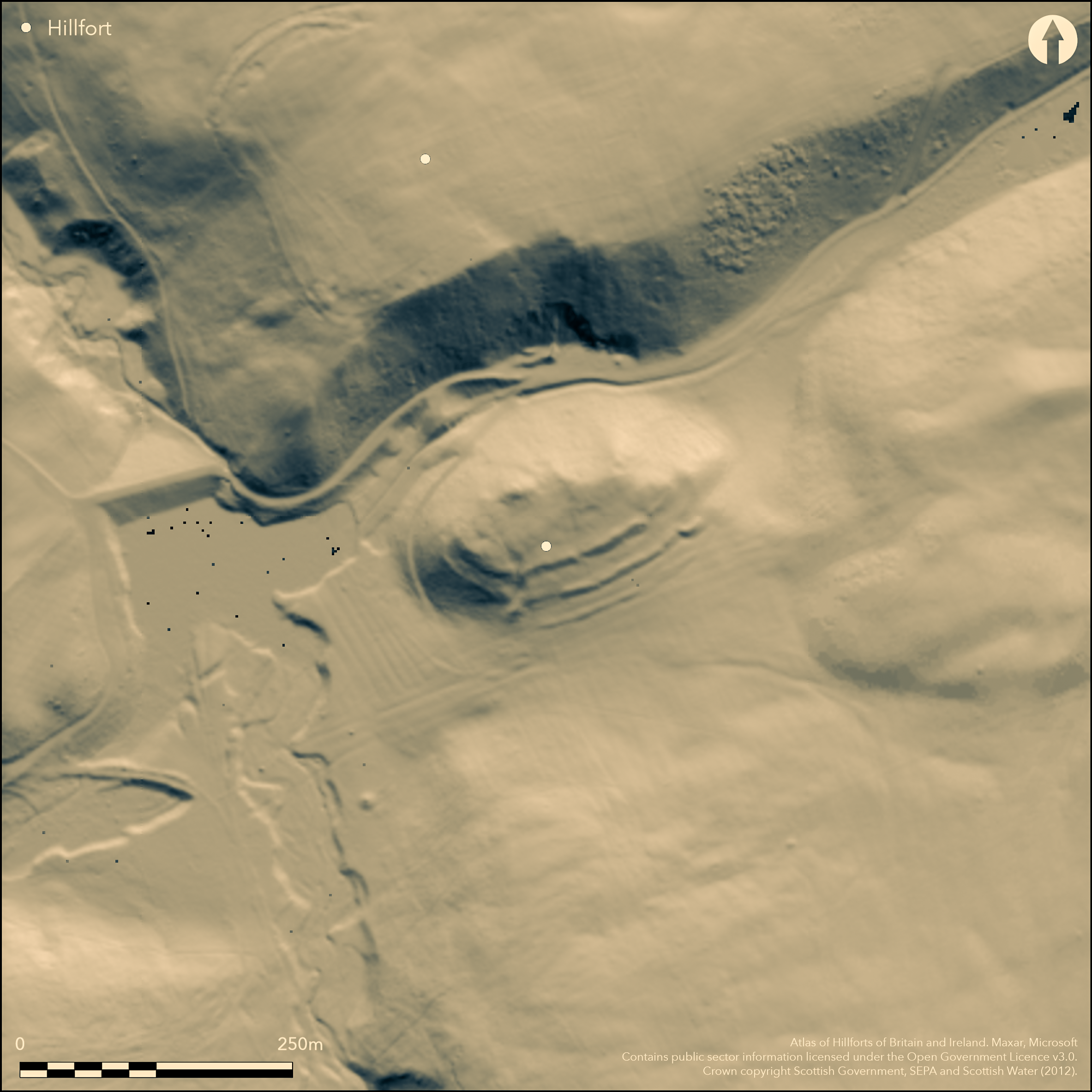
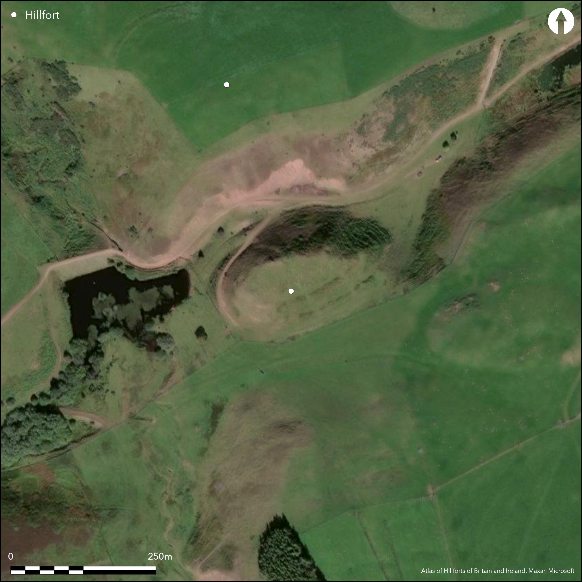
This fort is situated on a hillock on the S side of the steep-sided gully behind Highside Hill, at its intersection with the Kidlaw Burn. An elongated oval on plan, it measures internally 104m from ENE to WSW by a maximum of 40m in breadth. The ragged N flank is apparently unenclosed, though the slopes are by no mean unassailable, but elsewhere three ramparts have been constructed, forming a belt 30m deep. None of the ramparts is now more than 0.3m high internally, but externally the inner stands up to 2.4m in height, and though there is no clear evidence of a ditch the slope has almost certainly been cut back. Likewise the middle rampart stands 1.5m high externally, but here there are traces of a ditch in the central sector on the SSE, while at either end its line is taken up by a terrace swinging round the slope below the inner rampart. The outer rampart, which has bee overridden by rig and furrow, is visible only in the central sector and is also accompanied by an external ditch. There are two entrances, one on the ESE and the other on the SSW, and both display a curious feature at the gap in the middle rampart, where one of the terminals doglegs outwards to overlap the other. In the case of the SSW entrance, this may be fortuitous, resulting from the way the worn hollow forming the entrance way mounts an outcrop on the E side of the gap, but on the ESE a spur of the rampart has been extends outwards on the W side of the gap to overlap the opposite terminal. Within the WSW end of the interior there are traces of at least three ring-ditch houses, while several scooped platforms can be seen elsewhere.
Citizen Science: ✗
Reliability of Data: Confirmed
Reliability of Interpretation: Confirmed
X: -308435 Y: 7531161 (EPSG: 3857)
Longitude: -2.770715180262369 Latitude: 55.86284707899803 (EPSG:4326)
Country: Scotland
Current County or Unitary Authority: East Lothian
Historic County: East Lothian
Current Parish/Community/Council/Townland: Yester
None
| Extant | ✓ |
| Cropmark | ✗ |
| Likely Destroyed | ✗ |
None
| Woodland | ✗ |
| Commercial Forestry Plantation | ✗ |
| Parkland | ✗ |
| Pasture (Grazing) | ✓ |
| Arable | ✗ |
| Scrub/Bracken | ✗ |
| Bare Outcrop | ✗ |
| Heather/Moorland | ✓ |
| Heath | ✗ |
| Built-up | ✗ |
| Coastal Grassland | ✗ |
| Other | ✗ |
None
| Contour Fort | ✓ |
| Partial Contour Fort | ✗ |
| Promontory Fort | ✗ |
| Hillslope Fort | ✗ |
| Level Terrain Fort | ✗ |
| Marsh Fort | ✗ |
| Multiple Enclosure Fort | ✗ |
| Hilltop | ✗ |
| Coastal Promontory | ✗ |
| Inland Promontory | ✗ |
| Valley Bottom | ✗ |
| Knoll/Hillock/Outcrop | ✓ |
| Ridge | ✗ |
| Cliff/Plateau-edge/Scarp | ✗ |
| Hillslope | ✗ |
| Lowland | ✗ |
| Spur | ✗ |
Dominant Topographic Feature: None
| North | ✗ |
| Northeast | ✗ |
| East | ✗ |
| Southeast | ✗ |
| South | ✗ |
| Southwest | ✗ |
| West | ✗ |
| Northwest | ✗ |
| Level | ✓ |
Altitude: 300.0m
N/A
In the absence of excavation, there are neither stratified artefacts nor radiocarbon dates to provide a chronology for the defences.
Reliability: D - None
| Pre 1200BC | ✗ |
| 1200BC - 800BC | ✗ |
| 800BC - 400BC | ✗ |
| 400BC - AD50 | ✗ |
| AD50 - AD400 | ✗ |
| AD400 - AD 800 | ✗ |
| Post AD800 | ✗ |
| Unknown | ✓ |
| Pre Hillfort: | None |
| Post Hillfort: | None |
Photographed by John Dewar in 1971 (held by RCAHMS), by Mike Brookes of Historic Scotland, and RCAHMS Aerial Survey Programme 1988, 1991 and 2008
| 1st Identified Map Depiction (1853): | Annotated Fort on the 1st edition OS 6-inch map (Haddingtonshire 1854, sheet 19) |
| Other (1892): | Depicted on the OS 25-inch map (Haddingtonshire 1894, sheet 15.14) |
| Other (1913): | Description (RCAHMS 1924, 153, no.258) |
| Earthwork Survey (1954): | Plan and description during RCAHMS Survey of Marginal Lands (RCAHMS ELD 4/1; Feachem 1963, 122) |
| Other (1975): | Visited by the OS |
| Other (1979): | Visited by the OS |
| Other (1993): | Scheduled |
| Other (1994): | Re-Scheduled |
Traces of at least three ring-ditch houses at the WSW end of the interior and several platforms elsewhere
None
| None | ✓ |
| Spring | ✗ |
| Stream | ✗ |
| Pool | ✗ |
| Flush | ✗ |
| Well | ✗ |
| Other | ✗ |
Ring-ditch houses
| No Known Features | ✗ |
| Round Stone Structures | ✗ |
| Rectangular Stone Structures | ✗ |
| Curvilinear Platforms | ✓ |
| Other Roundhouse Evidence | ✓ |
| Pits | ✗ |
| Quarry Hollows | ✗ |
| Other | ✗ |
None
| No Known Excavation | ✓ |
| Pits | ✗ |
| Postholes | ✗ |
| Roundhouses | ✗ |
| Rectangular Structures | ✗ |
| Roads/Tracks | ✗ |
| Quarry Hollows | ✗ |
| Other | ✗ |
| Nothing Found | ✗ |
None
| No Known Geophysics | ✓ |
| Pits | ✗ |
| Roundhouses | ✗ |
| Rectangular Structures | ✗ |
| Roads/Tracks | ✗ |
| Quarry Hollows | ✗ |
| Other | ✗ |
| Nothing Found | ✗ |
None
| No Known Finds | ✓ |
| Pottery | ✗ |
| Metal | ✗ |
| Metalworking | ✗ |
| Human Bones | ✗ |
| Animal Bones | ✗ |
| Lithics | ✗ |
| Environmental | ✗ |
| Other | ✗ |
Ring-ditch houses visible
| APs Not Checked | ✗ |
| None | ✗ |
| Roundhouses | ✓ |
| Rectangular Structures | ✗ |
| Pits | ✗ |
| Postholes | ✗ |
| Roads/Tracks | ✗ |
| Other | ✗ |
See main summary
| 2: | None |
| 2: | None |
Guard Chambers: ✗
Chevaux de Frise: ✗
| 1. Over-lapping (South east): | Evidence of wear running up obliquely and an out-turned terminal on the middle rampart on the W side of the gap |
| 1. Oblique (South east): | Oblique approach exposing the visitor's right side |
| 1. Hornwork (South east): | Outurn of the middle rampart to form a shallow hornwork |
| 2. Over-lapping (South west): | With hollowed track running up into the interior and an out-turned terminal on the middle rampart on the E side of the gap |
| 2. Oblique (South west): | Oblique approach exposing the visitor's left side |
| 2. Hornwork (South west): | Outurn of the middle rampart to form a shallow hornwork |
Three ramparts on the most accessible side of the hillock
| Area 1: | 0.33ha. |
| Total: | 0.33ha. |
Total Footprint Area: 0.94ha.
None
| ✗ | None |
| ✗ | None |
| NE Quadrant: | 2 |
| SE Quadrant: | 3 |
| SW Quadrant: | 3 |
| NW Quadrant: | 0 |
| Total: | 3 |
| Partial Univallate | ✗ |
| Univallate | ✗ |
| Partial Bivallate | ✓ |
| Bivallate | ✗ |
| Partial Multivallate | ✓ |
| Multivallate | ✗ |
| Unknown | ✗ |
| Partial Univallate | ✗ |
| Univallate | ✗ |
| Partial Bivallate | ✗ |
| Bivallate | ✗ |
| Partial Multivallate | ✗ |
| Multivallate | ✗ |
The OS suggested the middle rampart was unfinished, with possible maker trenches to either side, but there is no evidence to sustain this, while in the case of the previous suggestion by RCAHMS investigators in 1954 that the outer was either unfinished or ploughed-down, the latter has clearly taken place.
| None | ✗ |
| Earthen Bank | ✓ |
| Stone Wall | ✗ |
| Rubble | ✗ |
| Wall-walk | ✗ |
| Evidence of Timber | ✗ |
| Vitrification | ✗ |
| Other Burning | ✗ |
| Palisade | ✗ |
| Counter Scarp Bank | ✗ |
| Berm | ✗ |
| Unfinished | ✓ |
| Other | ✗ |
None
| None | ✗ |
| Earthen Bank | ✗ |
| Stone Wall | ✗ |
| Murus Duplex | ✗ |
| Timber-framed | ✗ |
| Timber-laced | ✗ |
| Vitrification | ✗ |
| Other Burning | ✗ |
| Palisade | ✗ |
| Counter Scarp Bank | ✗ |
| Berm | ✗ |
| Unfinished | ✗ |
| No Known Excavation | ✓ |
| Other | ✗ |
| ✗ | None |
| ✓ | None |
Number of Ditches: 2
| ✗ | None |
Feachem, R W (1963) A guide to prehistoric Scotland. Batsford: London
RCAHMS (1924) The Royal Commission on the Ancient and Historical Monuments and Constructions of Scotland. Eighth report with Inventory of Monuments and Constructions in the County of East Lothian. HMSO: Edinburgh
Atlas of Hillforts:
Wikidata:
This work is licensed under CC BY-SA 4.0![]()
![]()
![]() and should be cited as:
and should be cited as:
Lock, Gary and Ralston, Ian. 2024. Atlas of Hillforts of Britain and Ireland. Available at: https://hillforts.arch.ox.ac.uk
Document Version 1.1