Satellite Imagery
Satellite Imagery
HER: East Lothian Council MEL804 (None)
NMR: NT 56 SW 6 (56203)
SM: 750
NGR: NT 5465 6309
X: 354650 Y: 663090 (OSGB36)
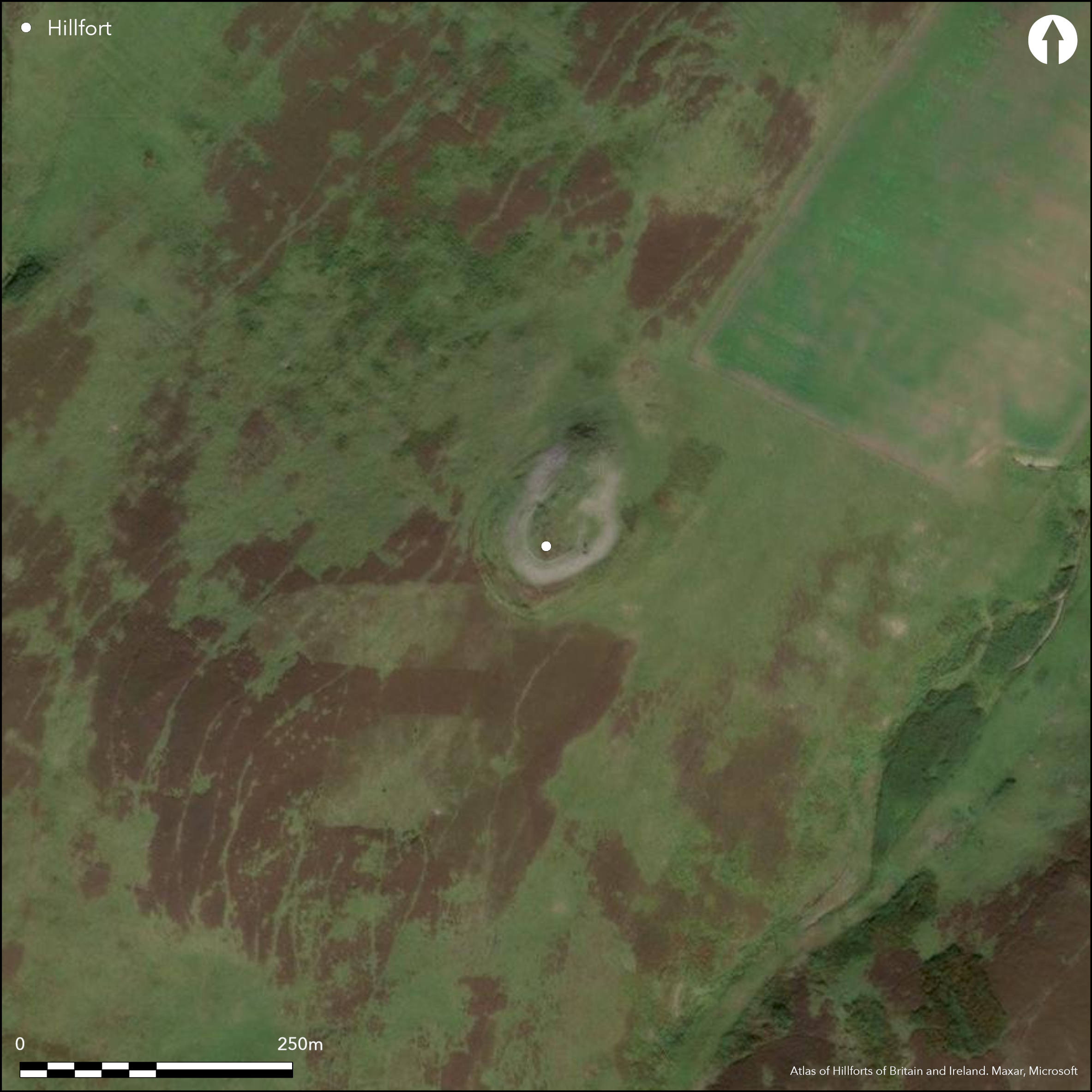
This fort occupies a local summit on the spur descending northwards from Crow Cairn on the W side of Soon Hope. The approach from the SW along the crest of the spur is very easy, but elsewhere the ground drops away sharply around a rocky spine. The defences comprise two main components, the inner a thick stone wall, which from the pieces of vitrified stone scattered round the circuit has evidently been timber-laced, and the outer up to two ramparts with external ditches blocking the SW approach and swinging round the flanks to either side. The area enclosed by the timber-laced wall has probably measured some 60m in length from NNE to SSW, and has tapered NNE from a maximum of 35m in breadth at the mid-point (0.15ha), though apart from the scree of debris along either flank little trace of the wall survives around the northern end of the spine; in part it has been robbed to build a relatively modern enclosure around the summit, but this end seems also to have suffered a catastrophic collapse down the slope. The two outer ramparts form a horseshoe-shaped arrangement around the broader SW end, returning to disappear beneath the scree along the flanks of the spine on the SE and NW respectively. At the well-defined entrance on the NW, they return and unite around the terminals of a ditch up to 5m broad, while the scree on the NE may mask a second entrance in the re-entrant formed between the ramparts and the SE flank of the spine. While essentially concentric, the two ramparts close up around this side, and there is also some evidence that they have been re-modelled on the S where the outer bifurcates, the inner, and upper, arm cutting sharply bacck towards the inner rampart, and the outer following the line of the external ditch, which on the crest of the spur is some 2m broad and 0.3m deep.
Citizen Science: ✗
Reliability of Data: Confirmed
Reliability of Interpretation: Confirmed
X: -303464 Y: 7530377 (EPSG: 3857)
Longitude: -2.7260635953101033 Latitude: 55.85889546278041 (EPSG:4326)
Country: Scotland
Current County or Unitary Authority: East Lothian
Historic County: East Lothian
Current Parish/Community/Council/Townland: Yester
None
| Extant | ✓ |
| Cropmark | ✗ |
| Likely Destroyed | ✗ |
None
| Woodland | ✗ |
| Commercial Forestry Plantation | ✗ |
| Parkland | ✗ |
| Pasture (Grazing) | ✓ |
| Arable | ✗ |
| Scrub/Bracken | ✗ |
| Bare Outcrop | ✗ |
| Heather/Moorland | ✓ |
| Heath | ✗ |
| Built-up | ✗ |
| Coastal Grassland | ✗ |
| Other | ✗ |
None
| Contour Fort | ✓ |
| Partial Contour Fort | ✗ |
| Promontory Fort | ✗ |
| Hillslope Fort | ✗ |
| Level Terrain Fort | ✗ |
| Marsh Fort | ✗ |
| Multiple Enclosure Fort | ✗ |
| Hilltop | ✓ |
| Coastal Promontory | ✗ |
| Inland Promontory | ✗ |
| Valley Bottom | ✗ |
| Knoll/Hillock/Outcrop | ✗ |
| Ridge | ✗ |
| Cliff/Plateau-edge/Scarp | ✗ |
| Hillslope | ✗ |
| Lowland | ✗ |
| Spur | ✓ |
Dominant Topographic Feature: None
| North | ✗ |
| Northeast | ✗ |
| East | ✗ |
| Southeast | ✗ |
| South | ✗ |
| Southwest | ✗ |
| West | ✗ |
| Northwest | ✗ |
| Level | ✓ |
Altitude: 365.0m
N/A
In the absence of excavation, there are neither stratified artefacts nor radiocarbon dates to provide a chronology for the defences.
Reliability: D - None
| Pre 1200BC | ✗ |
| 1200BC - 800BC | ✗ |
| 800BC - 400BC | ✗ |
| 400BC - AD50 | ✗ |
| AD50 - AD400 | ✗ |
| AD400 - AD 800 | ✗ |
| Post AD800 | ✗ |
| Unknown | ✓ |
| Pre Hillfort: | None |
| Post Hillfort: | Interior overlain by a later stone-walled enclosure of probably post-medieval date |
Photographed by John Dewar in 1971 (held by RCAHMS) and RCAHMS Aerial Survey Programme in 1980, 1988, 1991, 2007 and 2008. Ground views taken by Helen Nisbet in 1966 and of the vitrifaction in 1968. It is unclear why Lloyd Laing (1975, 10), should suggest that the entrance on the NW is a late feature and possibly post-Roman in date.
| 1st Identified Map Depiction (1773): | Marked as Harelaw Cairn on Andrew and Mostyn Armstrong's Map of the three Lothians (1773) |
| Other (1822): | Probably the site intended by the annotation Camp on John Thomson's map of Haddington (1822) |
| Other (1853): | Annotated Fort on the 1st edition OS 6-inch map (Haddingtonshire 1854, sheet 19) |
| Other (1892): | Depicted on the OS 25-inch map (Haddingtonshire 1894, sheet 15.16) |
| Earthwork Survey (1913): | Plan and description (RCAHMS 1924, 149-50, no.254, fig 185; RCAHMS ELD 13/1-5) |
| Other (1923): | Scheduled |
| Other (1954): | Description during RCAHMS Survey of Marginal Lands (Feachem 1963, 122-3) |
| Other (1961): | Re-Scheduled |
| Other (1965): | Visited by the OS |
| Other (1975): | Surveyed at 1:2500 by the OS |
Featureless apart from a telatively moder stone-walled enclosure
None
| None | ✓ |
| Spring | ✗ |
| Stream | ✗ |
| Pool | ✗ |
| Flush | ✗ |
| Well | ✗ |
| Other | ✗ |
None
| No Known Features | ✓ |
| Round Stone Structures | ✗ |
| Rectangular Stone Structures | ✗ |
| Curvilinear Platforms | ✗ |
| Other Roundhouse Evidence | ✗ |
| Pits | ✗ |
| Quarry Hollows | ✗ |
| Other | ✗ |
None
| No Known Excavation | ✓ |
| Pits | ✗ |
| Postholes | ✗ |
| Roundhouses | ✗ |
| Rectangular Structures | ✗ |
| Roads/Tracks | ✗ |
| Quarry Hollows | ✗ |
| Other | ✗ |
| Nothing Found | ✗ |
None
| No Known Geophysics | ✓ |
| Pits | ✗ |
| Roundhouses | ✗ |
| Rectangular Structures | ✗ |
| Roads/Tracks | ✗ |
| Quarry Hollows | ✗ |
| Other | ✗ |
| Nothing Found | ✗ |
None
| No Known Finds | ✓ |
| Pottery | ✗ |
| Metal | ✗ |
| Metalworking | ✗ |
| Human Bones | ✗ |
| Animal Bones | ✗ |
| Lithics | ✗ |
| Environmental | ✗ |
| Other | ✗ |
Later stone-walled enclosure
| APs Not Checked | ✗ |
| None | ✓ |
| Roundhouses | ✗ |
| Rectangular Structures | ✗ |
| Pits | ✗ |
| Postholes | ✗ |
| Roads/Tracks | ✗ |
| Other | ✗ |
See main summary
| 2: | None |
| 2: | None |
Guard Chambers: ✗
Chevaux de Frise: ✗
| 1. Simple Gap (North east): | Probably adapted to a shallow re-entrant |
| 2. Passage-way/Corridor (North west): | Ramparts return and unite around the ditch terminals to either side of the gap. |
Up to three ramparts, the innermost a timber-laced wall, around the gentle approach from the SW, but only the wall continued round the NE
| Area 1: | 0.15ha. |
| Total: | 0.15ha. |
Total Footprint Area: 0.6ha.
None
| ✗ | None |
| ✓ | None |
| NE Quadrant: | 1 |
| SE Quadrant: | 3 |
| SW Quadrant: | 3 |
| NW Quadrant: | 3 |
| Total: | 3 |
| Partial Univallate | ✓ |
| Univallate | ✗ |
| Partial Bivallate | ✗ |
| Bivallate | ✗ |
| Partial Multivallate | ✓ |
| Multivallate | ✗ |
| Unknown | ✗ |
| Partial Univallate | ✗ |
| Univallate | ✗ |
| Partial Bivallate | ✗ |
| Bivallate | ✗ |
| Partial Multivallate | ✗ |
| Multivallate | ✗ |
None
| None | ✗ |
| Earthen Bank | ✓ |
| Stone Wall | ✓ |
| Rubble | ✗ |
| Wall-walk | ✗ |
| Evidence of Timber | ✗ |
| Vitrification | ✓ |
| Other Burning | ✗ |
| Palisade | ✗ |
| Counter Scarp Bank | ✗ |
| Berm | ✗ |
| Unfinished | ✗ |
| Other | ✗ |
None
| None | ✗ |
| Earthen Bank | ✗ |
| Stone Wall | ✗ |
| Murus Duplex | ✗ |
| Timber-framed | ✗ |
| Timber-laced | ✗ |
| Vitrification | ✗ |
| Other Burning | ✗ |
| Palisade | ✗ |
| Counter Scarp Bank | ✗ |
| Berm | ✗ |
| Unfinished | ✗ |
| No Known Excavation | ✓ |
| Other | ✗ |
| ✗ | None |
| ✓ | None |
Number of Ditches: 2
| ✗ | None |
Feachem, R W (1963) A guide to prehistoric Scotland. Batsford: London
Laing, L R (1975) Settlement types in post-Roman Scotland. Brit Archaeol Rep, BAR British Ser 13. Oxford
RCAHMS (1924) The Royal Commission on the Ancient and Historical Monuments and Constructions of Scotland. Eighth report with Inventory of Monuments and Constructions in the County of East Lothian. HMSO: Edinburgh
Atlas of Hillforts:
Wikidata:
This work is licensed under CC BY-SA 4.0![]()
![]()
![]() and should be cited as:
and should be cited as:
Lock, Gary and Ralston, Ian. 2024. Atlas of Hillforts of Britain and Ireland. Available at: https://hillforts.arch.ox.ac.uk
Document Version 1.1