Satellite Imagery
Satellite Imagery
HER: East Lothian Council MEL1118 (None)
NMR: NT 57 SW 31 (56520)
SM: 3310
NGR: NT 5004 7075
X: 350043 Y: 670752 (OSGB36)
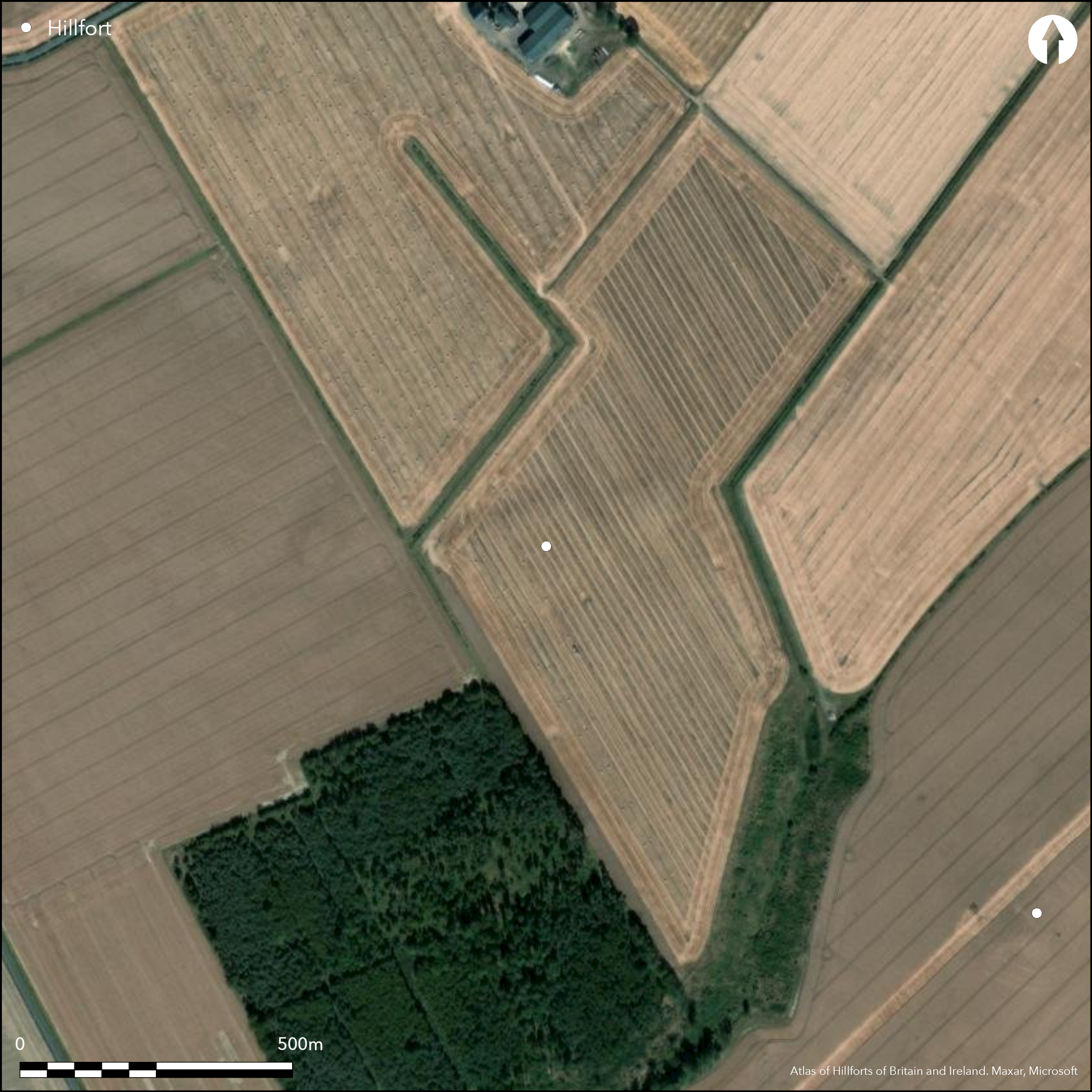
Cropmarks have revealed the site of a fort situated on a low rise in the broad floor of the Tyne valley ESE of Begbie. Oval on plan, its defences are only clearly defined at either end, comprising an inner ditch some 6m in breadth with three narrower ditches on the W, and two on the E. Thus defined, it measures about 105m from ENE to WSW by 80m transversely (0.65ha), and allowing for the presence of an inner rampart, the interior would have extended to about 0.52ha. The inner ditch, however, does not form a continuous circuit and it is particularly noticeable that on both the aerial photographs and a geophysical survey prepared in 2002 that the extended line of the W arc peters out on the N inside the line of the E arc. The discrepancy does not appear to be an elaborate entrance, and suggests either that the E arc is an internal quarry rather than an external ditch, or that this impression has been created by the eccentric superimposition of several phases of enclosure, this latter interpretation might also explain why the ditches are closely concentric on the WSW, but more wide-spaced on the ENE, there lying up to 10m apart. There are also two causeways across the inner ditch at this end, one on the ENE and the other on the E, the northern of which seems to correspond with gaps in the two outer ditches. On the N traces of a palisade trench are visible about 5m within the innermost ditch, but no coherent structures can be resolved from the other marks that can be seen scattered across the interior.
Citizen Science: ✗
Reliability of Data: Confirmed
Reliability of Interpretation: Confirmed
X: -311814 Y: 7543952 (EPSG: 3857)
Longitude: -2.8010732242663385 Latitude: 55.92727583403391 (EPSG:4326)
Country: Scotland
Current County or Unitary Authority: East Lothian
Historic County: East Lothian
Current Parish/Community/Council/Townland: Haddington
None
| Extant | ✗ |
| Cropmark | ✓ |
| Likely Destroyed | ✗ |
None
| Woodland | ✗ |
| Commercial Forestry Plantation | ✗ |
| Parkland | ✗ |
| Pasture (Grazing) | ✗ |
| Arable | ✓ |
| Scrub/Bracken | ✗ |
| Bare Outcrop | ✗ |
| Heather/Moorland | ✗ |
| Heath | ✗ |
| Built-up | ✗ |
| Coastal Grassland | ✗ |
| Other | ✗ |
None
| Contour Fort | ✓ |
| Partial Contour Fort | ✗ |
| Promontory Fort | ✗ |
| Hillslope Fort | ✗ |
| Level Terrain Fort | ✗ |
| Marsh Fort | ✗ |
| Multiple Enclosure Fort | ✗ |
| Hilltop | ✗ |
| Coastal Promontory | ✗ |
| Inland Promontory | ✗ |
| Valley Bottom | ✗ |
| Knoll/Hillock/Outcrop | ✓ |
| Ridge | ✗ |
| Cliff/Plateau-edge/Scarp | ✗ |
| Hillslope | ✗ |
| Lowland | ✓ |
| Spur | ✗ |
Dominant Topographic Feature: None
| North | ✗ |
| Northeast | ✗ |
| East | ✗ |
| Southeast | ✗ |
| South | ✗ |
| Southwest | ✗ |
| West | ✗ |
| Northwest | ✗ |
| Level | ✓ |
Altitude: 60.0m
N/A
In the absence of excavation, there are neither stratified artefacts nor radiocarbon dates to provide a chronology for the defences.
Reliability: D - None
| Pre 1200BC | ✗ |
| 1200BC - 800BC | ✗ |
| 800BC - 400BC | ✗ |
| 400BC - AD50 | ✗ |
| AD50 - AD400 | ✗ |
| AD400 - AD 800 | ✗ |
| Post AD800 | ✗ |
| Unknown | ✓ |
| Pre Hillfort: | None |
| Post Hillfort: | Ploughed flat |
Photographed by CUCAP in 1959, 1962, 1964, 1970, 1972, 1977, 1978 and 1981, by John Dewar in 1972 (held by RCAHMS) and RCAHMS Aerial Survey Programme in 1977, 1978, 1986, 1989, 1990, 1991, 1992, 1995 and 1999
| 1st Identified Written Reference (1954): | First identified Description during RCAHMS Survey of Marginal Lands |
| Other (1973): | Scheduled |
| Other (1975): | Visited by the OS |
| Geophysical Survey (2002): | Carried out as part of the Traprain Law Environs Project |
Scatter of features visible on the photographs but they do not resolve into coherent structures
None
| None | ✓ |
| Spring | ✗ |
| Stream | ✗ |
| Pool | ✗ |
| Flush | ✗ |
| Well | ✗ |
| Other | ✗ |
None
| No Known Features | ✓ |
| Round Stone Structures | ✗ |
| Rectangular Stone Structures | ✗ |
| Curvilinear Platforms | ✗ |
| Other Roundhouse Evidence | ✗ |
| Pits | ✗ |
| Quarry Hollows | ✗ |
| Other | ✗ |
None
| No Known Excavation | ✓ |
| Pits | ✗ |
| Postholes | ✗ |
| Roundhouses | ✗ |
| Rectangular Structures | ✗ |
| Roads/Tracks | ✗ |
| Quarry Hollows | ✗ |
| Other | ✗ |
| Nothing Found | ✗ |
None
| No Known Geophysics | ✓ |
| Pits | ✗ |
| Roundhouses | ✗ |
| Rectangular Structures | ✗ |
| Roads/Tracks | ✗ |
| Quarry Hollows | ✗ |
| Other | ✗ |
| Nothing Found | ✗ |
None
| No Known Finds | ✓ |
| Pottery | ✗ |
| Metal | ✗ |
| Metalworking | ✗ |
| Human Bones | ✗ |
| Animal Bones | ✗ |
| Lithics | ✗ |
| Environmental | ✗ |
| Other | ✗ |
several short linear features
| APs Not Checked | ✗ |
| None | ✗ |
| Roundhouses | ✗ |
| Rectangular Structures | ✗ |
| Pits | ✓ |
| Postholes | ✗ |
| Roads/Tracks | ✗ |
| Other | ✓ |
See main summary
| 2: | Two causeways at the eastern end |
| 2: | None |
Guard Chambers: ✗
Chevaux de Frise: ✗
| 1. Simple Gap (North east): | Through all three ditches |
Between three and four ditches, but probably representing several periods of construction
| Area 1: | 0.52ha. |
| Total: | 0.52ha. |
Total Footprint Area: Noneha.
None
| ✓ | The misalignment of the various sectors of the ditches suggests multi-period construction |
| ✓ | None |
| NE Quadrant: | 3 |
| SE Quadrant: | 1 |
| SW Quadrant: | 4 |
| NW Quadrant: | 2 |
| Total: | 4 |
| Partial Univallate | ✓ |
| Univallate | ✗ |
| Partial Bivallate | ✓ |
| Bivallate | ✗ |
| Partial Multivallate | ✓ |
| Multivallate | ✗ |
| Unknown | ✗ |
| Partial Univallate | ✗ |
| Univallate | ✗ |
| Partial Bivallate | ✗ |
| Bivallate | ✗ |
| Partial Multivallate | ✗ |
| Multivallate | ✗ |
None
| None | ✓ |
| Earthen Bank | ✗ |
| Stone Wall | ✗ |
| Rubble | ✗ |
| Wall-walk | ✗ |
| Evidence of Timber | ✗ |
| Vitrification | ✗ |
| Other Burning | ✗ |
| Palisade | ✗ |
| Counter Scarp Bank | ✗ |
| Berm | ✗ |
| Unfinished | ✗ |
| Other | ✗ |
None
| None | ✗ |
| Earthen Bank | ✗ |
| Stone Wall | ✗ |
| Murus Duplex | ✗ |
| Timber-framed | ✗ |
| Timber-laced | ✗ |
| Vitrification | ✗ |
| Other Burning | ✗ |
| Palisade | ✗ |
| Counter Scarp Bank | ✗ |
| Berm | ✗ |
| Unfinished | ✗ |
| No Known Excavation | ✓ |
| Other | ✗ |
| ✗ | None |
| ✓ | None |
Number of Ditches: 4
| ✗ | None |
No related records
Atlas of Hillforts:
Wikidata:
This work is licensed under CC BY-SA 4.0![]()
![]()
![]() and should be cited as:
and should be cited as:
Lock, Gary and Ralston, Ian. 2024. Atlas of Hillforts of Britain and Ireland. Available at: https://hillforts.arch.ox.ac.uk
Document Version 1.1