LiDAR 1m DTM Hillshade
Satellite Imagery
LiDAR 1m DTM Hillshade
Satellite Imagery
Scroll left/right to view further images.
HER: East Lothian Council MEL1343 (None)
NMR: NT 58 SW 2 (56749)
SM: None
NGR: NT 5082 8349
X: 350820 Y: 683490 (OSGB36)
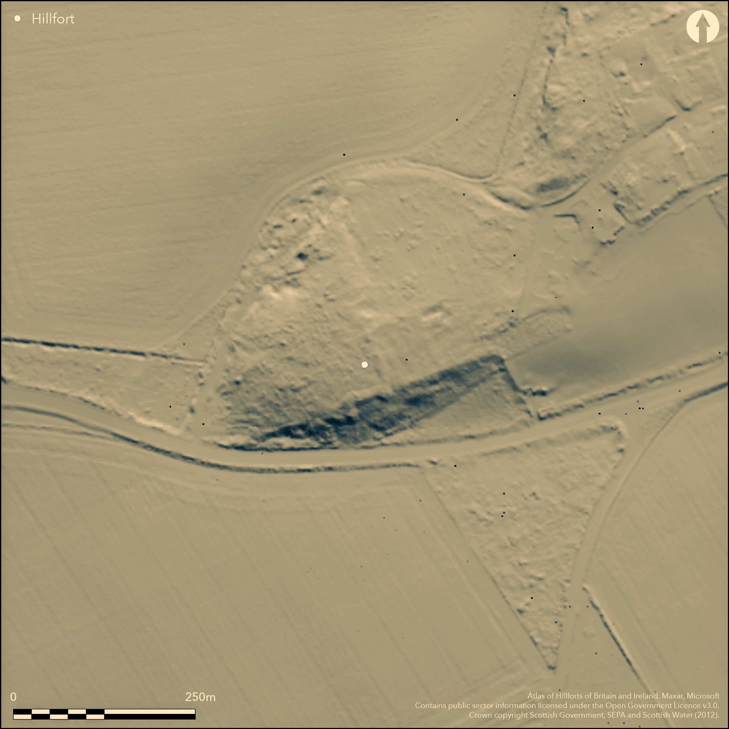
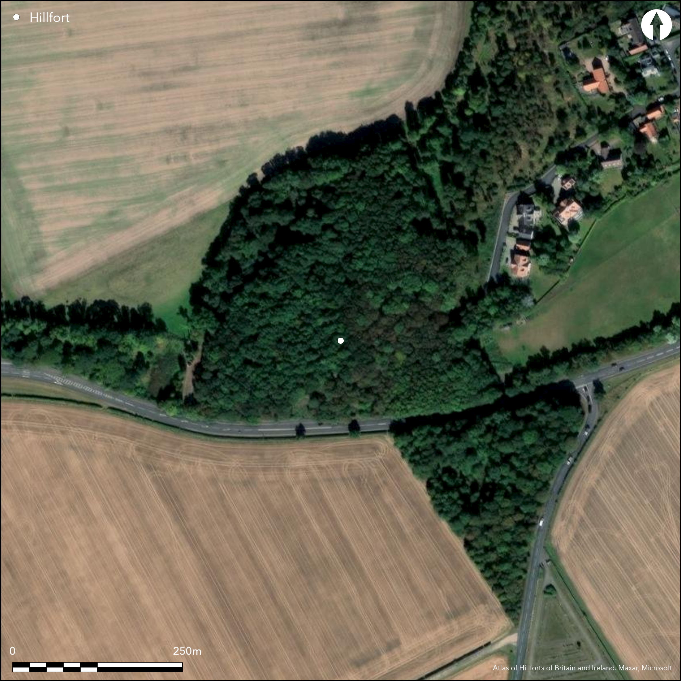
This fort occupied a knoll forming the SW tip of a low spur within Craigs Plantation, but having been first quarried in the 19th century before its existence was recognised, it had been destroyed by the early 1960s. The size and shape of the fort is thus unknown, but excavations carried out in 1949 and 1954-55 sectioned the rampart in two places on the N and NE respectively and uncovered the greater part of a round-house within the interior, apparently buried beneath a deep deposit of demolition debris from the defences (Piggott and Piggott 1952, 194-6; Piggott 1958, 66-7). The rampart varied between 3m and 4.2m in thickness and the neatly-built faces still stood some 0.9m high. In the first section, the wall core contained midden material which had been tipped in from the interior, while other midden had accumulated against the inner face and covered a hearth within the interior. The excavated round-house measured some 9m in diameter and is notable for the mound of weathered daub found on the outer lip of a foundation trench for its timber wall. The demolition debris overlying the round-house incorporated three Roman sherds of 1st-2nd century AD date, while finds from the house floor included a bronze brooch, a fragment of a bronze binding, a spindle whorl, whetstone, an unfinished shale ring, a fragment of shale armlet and a quantity of coarse pottery. Finds from the rampart section cut in 1949 also included coarse pottery, a fragment of a mould for casting a bronze object, stone balls and the upper stone of a rotary quern. Five long cists have also been discovered in the interior (Henshall 1954; Simpson 1958).
Citizen Science: ✗
Reliability of Data: Confirmed
Reliability of Interpretation: Confirmed
X: -310690 Y: 7566740 (EPSG: 3857)
Longitude: -2.7909721279354978 Latitude: 56.04179466001879 (EPSG:4326)
Country: Scotland
Current County or Unitary Authority: East Lothian
Historic County: East Lothian
Current Parish/Community/Council/Townland: Dirleton
Totally destroyed by quarrying
| Extant | ✗ |
| Cropmark | ✗ |
| Likely Destroyed | ✓ |
Reverted to woodland
| Woodland | ✓ |
| Commercial Forestry Plantation | ✗ |
| Parkland | ✗ |
| Pasture (Grazing) | ✗ |
| Arable | ✗ |
| Scrub/Bracken | ✗ |
| Bare Outcrop | ✗ |
| Heather/Moorland | ✗ |
| Heath | ✗ |
| Built-up | ✗ |
| Coastal Grassland | ✗ |
| Other | ✗ |
Unknown, but probably a contour fort
| Contour Fort | ✗ |
| Partial Contour Fort | ✗ |
| Promontory Fort | ✗ |
| Hillslope Fort | ✗ |
| Level Terrain Fort | ✗ |
| Marsh Fort | ✗ |
| Multiple Enclosure Fort | ✗ |
| Hilltop | ✗ |
| Coastal Promontory | ✗ |
| Inland Promontory | ✗ |
| Valley Bottom | ✗ |
| Knoll/Hillock/Outcrop | ✓ |
| Ridge | ✗ |
| Cliff/Plateau-edge/Scarp | ✗ |
| Hillslope | ✗ |
| Lowland | ✗ |
| Spur | ✗ |
Dominant Topographic Feature: None
| North | ✗ |
| Northeast | ✗ |
| East | ✗ |
| Southeast | ✗ |
| South | ✗ |
| Southwest | ✗ |
| West | ✗ |
| Northwest | ✗ |
| Level | ✓ |
Altitude: 45.0m
N/A
There are neither stratified artefacts nor radiocarbon dates to provide a chronology for the defences.
Reliability: C - Low
| Pre 1200BC | ✗ |
| 1200BC - 800BC | ✗ |
| 800BC - 400BC | ✗ |
| 400BC - AD50 | ✗ |
| AD50 - AD400 | ✓ |
| AD400 - AD 800 | ✗ |
| Post AD800 | ✗ |
| Unknown | ✓ |
| Pre Hillfort: | None |
| Post Hillfort: | At least five long cists found within the interior, in which the 1st century AD finds may in any case suggest a late Iron Age occupation post-dating the defences. Subsequently planted with trees and quarried |
| Artefactual: | A brooch and three sherds of Roman pottery, but their contexts in relation to the defences are unknown |
No visits since the OS in 1962 to confirm the total removal of this fort.
| 1st Identified Written Reference (1943): | Two stone balls donated by Gordon Childe to the NMAS (Proc Soc Antiq Scot 78, 1943-4, 140) implies that Childe visited the quarry during wartime emergency surveys, thus providing the link for later excavations. |
| Excavation (1949): | Rampart sectioned (Piggott and Piggott 1949; 1952, 194-6) |
| Excavation (1954): | Excavation of long cists and house and rampart section (Henshall 1954; 1955) |
| Excavation (1955): | Excavation of house and rampart section (Burley 1955; Piggott 1958, 66-7) |
| Excavation (1958): | Further long-cists (Simpson 1958) |
| Other (1962): | OS can find no trace of the fort surviving, unless then buried beneath topsoil dumps. |
Single round-house found by excavation, in addition to at least five long cists
None
| None | ✓ |
| Spring | ✗ |
| Stream | ✗ |
| Pool | ✗ |
| Flush | ✗ |
| Well | ✗ |
| Other | ✗ |
None
| No Known Features | ✓ |
| Round Stone Structures | ✗ |
| Rectangular Stone Structures | ✗ |
| Curvilinear Platforms | ✗ |
| Other Roundhouse Evidence | ✗ |
| Pits | ✗ |
| Quarry Hollows | ✗ |
| Other | ✗ |
Single round-house with wall-trench and mound of weathered daub, stone pitching on part of the floor and a hearth
| No Known Excavation | ✗ |
| Pits | ✓ |
| Postholes | ✓ |
| Roundhouses | ✓ |
| Rectangular Structures | ✗ |
| Roads/Tracks | ✗ |
| Quarry Hollows | ✗ |
| Other | ✗ |
| Nothing Found | ✗ |
None
| No Known Geophysics | ✓ |
| Pits | ✗ |
| Roundhouses | ✗ |
| Rectangular Structures | ✗ |
| Roads/Tracks | ✗ |
| Quarry Hollows | ✗ |
| Other | ✗ |
| Nothing Found | ✗ |
The demolition debris overlying the round-house incorporated three Roman sherds of 1st-2nd century AD date, while finds from the house floor included a bronze brooch, a fragment of a bronze binding, a spindle whorl, whetstone, an unfinished shale ring, a fragment of shale armlet and a quantity of coarse pottery. Finds from the rampart section cut in 1949 also included coarse pottery, a fragment of a mould for casting a bronze object, stone balls and the upper stone of a rotary quern.
| No Known Finds | ✗ |
| Pottery | ✓ |
| Metal | ✓ |
| Metalworking | ✓ |
| Human Bones | ✓ |
| Animal Bones | ✗ |
| Lithics | ✓ |
| Environmental | ✗ |
| Other | ✓ |
NO APPARENT FEATURES
| APs Not Checked | ✓ |
| None | ✗ |
| Roundhouses | ✗ |
| Rectangular Structures | ✗ |
| Pits | ✗ |
| Postholes | ✗ |
| Roads/Tracks | ✗ |
| Other | ✗ |
None known
| 0: | None |
| 2: | None known |
Guard Chambers: ✗
Chevaux de Frise: ✗
Single rampart recorded on the N and NE; plan and extent unknown
| Area 1: | Noneha. |
| Total: | Noneha. |
Total Footprint Area: Noneha.
None
| ✗ | None |
| ✗ | Plan unknown |
| NE Quadrant: | 1 |
| SE Quadrant: | 0 |
| SW Quadrant: | 0 |
| NW Quadrant: | 0 |
| Total: | 1 |
| Partial Univallate | ✓ |
| Univallate | ✗ |
| Partial Bivallate | ✗ |
| Bivallate | ✗ |
| Partial Multivallate | ✗ |
| Multivallate | ✗ |
| Unknown | ✗ |
| Partial Univallate | ✗ |
| Univallate | ✗ |
| Partial Bivallate | ✗ |
| Bivallate | ✗ |
| Partial Multivallate | ✗ |
| Multivallate | ✗ |
None
| None | ✗ |
| Earthen Bank | ✗ |
| Stone Wall | ✓ |
| Rubble | ✗ |
| Wall-walk | ✗ |
| Evidence of Timber | ✗ |
| Vitrification | ✗ |
| Other Burning | ✗ |
| Palisade | ✗ |
| Counter Scarp Bank | ✗ |
| Berm | ✗ |
| Unfinished | ✗ |
| Other | ✗ |
None
| None | ✗ |
| Earthen Bank | ✗ |
| Stone Wall | ✓ |
| Murus Duplex | ✗ |
| Timber-framed | ✗ |
| Timber-laced | ✗ |
| Vitrification | ✗ |
| Other Burning | ✗ |
| Palisade | ✗ |
| Counter Scarp Bank | ✗ |
| Berm | ✗ |
| Unfinished | ✗ |
| No Known Excavation | ✗ |
| Other | ✗ |
| ✗ | None |
| ✗ | None |
Number of Ditches: None
| ✗ | None |
Burley, E (1955) «Craig's Quarry, Dirleton». Disc Exc Scot (1955), 15
Henshall, A S (1955) «East Lothian, Craigs Quarry, Dirleton». Archaeol Newsletter 5.12, (1955), 254
Henshall, A S (1954) «East Lothian, Craig's Quarry, Dirleton». Disc Exc Scot (1954), 9
Piggott and Piggott, S and C M (1952) «Excavations at Castle Law, Glencorse, and at Craig's Quarry, Dirleton, 1948-9». Proc Soc Antiq Scot 86 (1951-2), 191-6
Piggott and Piggott, S and C M (1949) «Craig's Quarry, Dirleton». Disc Exc Scot (1949), 9
Piggott, S. (1958) «Excavations at Braidwood Fort, Midlothian and Craig's Quarry, Dirleton, East Lothian». Proc Soc Antiq Scot 91 (1957-8), 61-77
Simpson, D D A (1958) «Craigs Quarry, Dirleton». Disc Exc Scot (1958), 21-2
Atlas of Hillforts:
Wikidata:
This work is licensed under CC BY-SA 4.0![]()
![]()
![]() and should be cited as:
and should be cited as:
Lock, Gary and Ralston, Ian. 2024. Atlas of Hillforts of Britain and Ireland. Available at: https://hillforts.arch.ox.ac.uk
Document Version 1.1