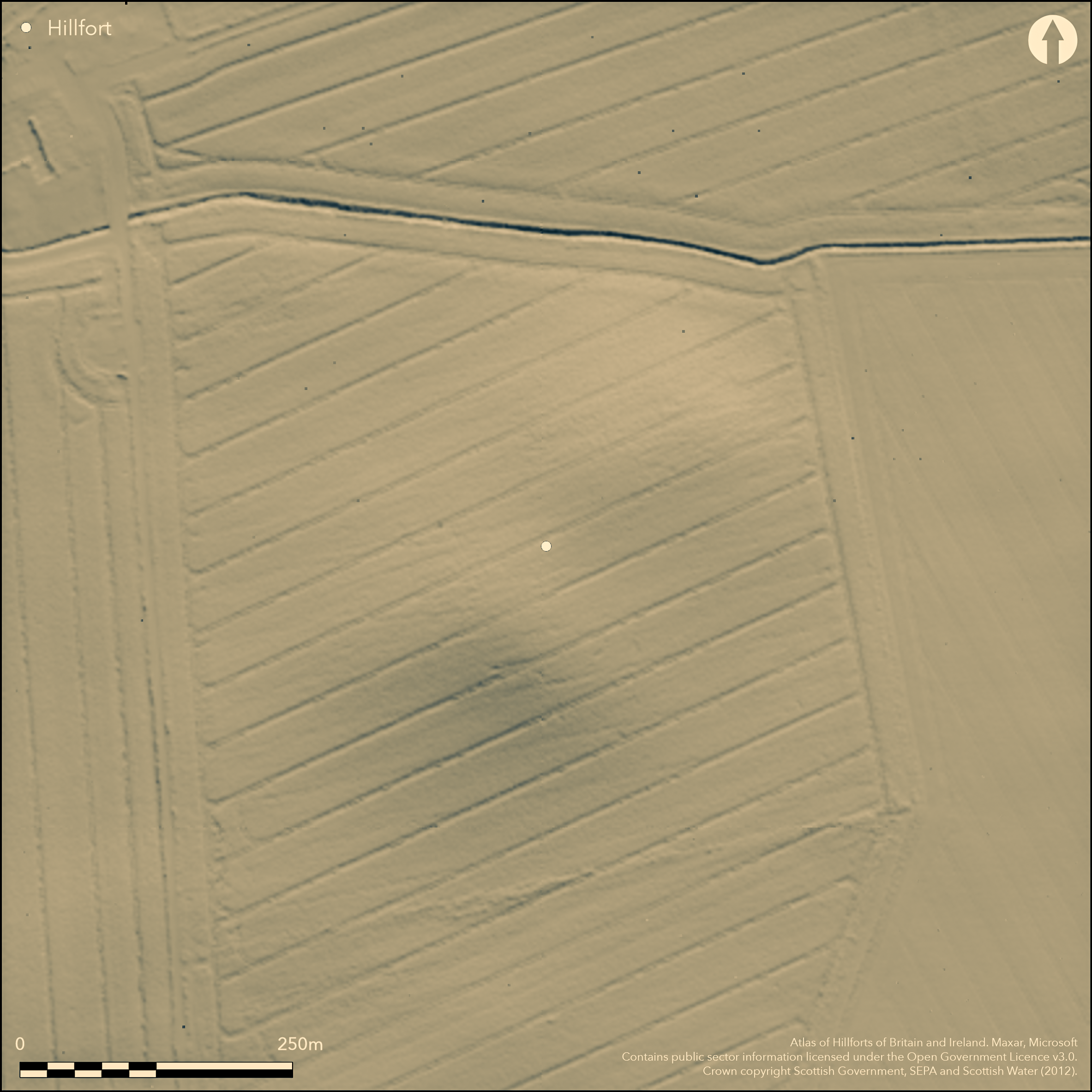
LiDAR 1m DTM Hillshade
Satellite Imagery
LiDAR 1m DTM Hillshade
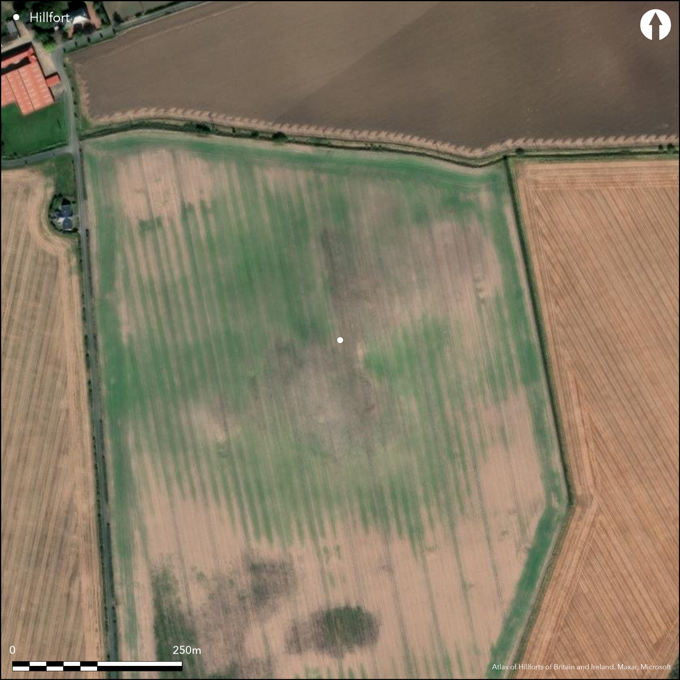
Satellite Imagery
Scroll left/right to view further images.
HER: East Lothian Council MEL1334 (None)
NMR: NT 58 SW 11 (56740)
SM: 5867
NGR: NT 5393 8355
X: 353931 Y: 683552 (OSGB36)
This fort is situated on a low hillock and while its existence as an earthwork is perhaps recorded in the tradition of an encampment here of Edward I (Name Book, Haddingtonshire, No.25, p 29, 74), it had probably been ploughed down before the 19th century. Cropmarks however reveal that it is roughly sub-rectangular on plan, measuring about 130m from NNE to SSW and tapering from about 74m transversely on the SSW to 50m on the NNE (0.78ha) within for most of the circuit four ditches, a fifth being present at the SSW end. Making some allowance for the presence of an inner rampart, the interior extends to about 0.58ha. The defences, however, which form a belt between 33m and 43m in depth, are evidently complex, and of the four entrances that are visible, on the NE, SE, SW and WNW respectively, those on the NE and WNW appear to have been blocked on the line of the second ditch, and the NE entrance on the line of the third ditch too. Indeed the simple character of the unblocked innermost causeways at these entrances, with directly opposed ditch terminals, contrasts with the elaboration of the outer entrances, and though the sequence of construction is unknown strongly suggests that innermost and outer lines were not conceived as a single scheme. At the NE entrance a spur of the innermost ditch doglegs outwards from the S terminal, but at the blocked gap in the second ditch the N terminal appears originally to have overlapped the southern externally. Similar elaborations are visible elsewhere, with overlaps created by realigning one side of the second and third ditches at the SE entrance, the third ditch to oppose an inturned terminal of the fourth ditch at the SW entrance, and the second and third ditches at the WNW entrance. At both the SE and WNW entrances the causeways across the ditches have also been staggered to create oblique approaches, the former exposing the visitor's left side, and the latter the right side. Heavy wear is apparent at the NW entrance, splaying out into the interior immediately within the innermost ditch. A shallow fold in the E flank of the hillock appears as a relatively dark area of cropmarks, possibly containing deeper sediments, but no structures are visible within the interior.
Citizen Science: ✗
Reliability of Data: Confirmed
Reliability of Interpretation: Confirmed
X: -305133 Y: 7566913 (EPSG: 3857)
Longitude: -2.7410521151830194 Latitude: 56.04266162277775 (EPSG:4326)
Country: Scotland
Current County or Unitary Authority: East Lothian
Historic County: East Lothian
Current Parish/Community/Council/Townland: Dirleton
None
| Extant | ✗ |
| Cropmark | ✓ |
| Likely Destroyed | ✗ |
None
| Woodland | ✗ |
| Commercial Forestry Plantation | ✗ |
| Parkland | ✗ |
| Pasture (Grazing) | ✗ |
| Arable | ✓ |
| Scrub/Bracken | ✗ |
| Bare Outcrop | ✗ |
| Heather/Moorland | ✗ |
| Heath | ✗ |
| Built-up | ✗ |
| Coastal Grassland | ✗ |
| Other | ✗ |
None
| Contour Fort | ✓ |
| Partial Contour Fort | ✗ |
| Promontory Fort | ✗ |
| Hillslope Fort | ✗ |
| Level Terrain Fort | ✗ |
| Marsh Fort | ✗ |
| Multiple Enclosure Fort | ✗ |
| Hilltop | ✗ |
| Coastal Promontory | ✗ |
| Inland Promontory | ✗ |
| Valley Bottom | ✗ |
| Knoll/Hillock/Outcrop | ✓ |
| Ridge | ✗ |
| Cliff/Plateau-edge/Scarp | ✗ |
| Hillslope | ✗ |
| Lowland | ✗ |
| Spur | ✗ |
Dominant Topographic Feature: None
| North | ✗ |
| Northeast | ✗ |
| East | ✗ |
| Southeast | ✗ |
| South | ✗ |
| Southwest | ✗ |
| West | ✗ |
| Northwest | ✗ |
| Level | ✓ |
Altitude: 65.0m
N/A
In the absence of excavation, there are neither stratified artefacts nor radiocarbon dates to provide a chronology for the defences.
Reliability: D - None
| Pre 1200BC | ✗ |
| 1200BC - 800BC | ✗ |
| 800BC - 400BC | ✗ |
| 400BC - AD50 | ✗ |
| AD50 - AD400 | ✗ |
| AD400 - AD 800 | ✗ |
| Post AD800 | ✗ |
| Unknown | ✓ |
| Pre Hillfort: | None |
| Post Hillfort: | Ploughed flat |
The name Kilmurdie attached to this hillock appears in the OS Name Book (No.25, p 29, 74), which records a tradition that this was the site of an encampment of Edward I besieging Dirleton Castle in 1298, and infers that burials found in this field indicated that the place-name referred to the site of a chapel. East Lothian Council HER note a communication with Simon Taylor to the effect that the Kilmurdie place-name is a corruption of Karmurdath or Carmudac, but rather than being a caer place-name, indicating a fort, in this instance derives from the Gaelic 'ceathramh m(h)uradaich', meaning Murdoch's Quarter. The fort was photographed by CUCAP in 1948, 1962 and 1966, Colin Martin in 1984, and RCAHMS Aerial Survey Programme in 1976, 1981, 1989, 1990, 1991, 1992, 1993, 1994, 1995, 2006, 2009 and 2012
| 1st Identified Written Reference (1853): | The tradition of an encampment of Edward I probably contains a memory of the standing earthworks of the fort (Name Book, Haddingtonshire, No.25, p 29, 74) |
| Other (1962): | First photographed by CUCAP |
| Other (1975): | Visited by the OS |
| Other (1993): | Scheduled |
No structures are visible, though a darker area of cropmarks probably indicates deeper sediments on the E side
None
| None | ✓ |
| Spring | ✗ |
| Stream | ✗ |
| Pool | ✗ |
| Flush | ✗ |
| Well | ✗ |
| Other | ✗ |
None
| No Known Features | ✓ |
| Round Stone Structures | ✗ |
| Rectangular Stone Structures | ✗ |
| Curvilinear Platforms | ✗ |
| Other Roundhouse Evidence | ✗ |
| Pits | ✗ |
| Quarry Hollows | ✗ |
| Other | ✗ |
None
| No Known Excavation | ✓ |
| Pits | ✗ |
| Postholes | ✗ |
| Roundhouses | ✗ |
| Rectangular Structures | ✗ |
| Roads/Tracks | ✗ |
| Quarry Hollows | ✗ |
| Other | ✗ |
| Nothing Found | ✗ |
None
| No Known Geophysics | ✓ |
| Pits | ✗ |
| Roundhouses | ✗ |
| Rectangular Structures | ✗ |
| Roads/Tracks | ✗ |
| Quarry Hollows | ✗ |
| Other | ✗ |
| Nothing Found | ✗ |
None
| No Known Finds | ✓ |
| Pottery | ✗ |
| Metal | ✗ |
| Metalworking | ✗ |
| Human Bones | ✗ |
| Animal Bones | ✗ |
| Lithics | ✗ |
| Environmental | ✗ |
| Other | ✗ |
NO APPARENT FEATURES
| APs Not Checked | ✗ |
| None | ✓ |
| Roundhouses | ✗ |
| Rectangular Structures | ✗ |
| Pits | ✗ |
| Postholes | ✗ |
| Roads/Tracks | ✗ |
| Other | ✗ |
See main summary
| 4: | The whole circuit has been ploughed flat |
| 2: | None |
Guard Chambers: ✗
Chevaux de Frise: ✗
| 1. Over-lapping (North east): | Staggered terminals in the outer ditches. Oblique approach exposing left side |
| 1. Blocked (North east): | The ditch has been extended across the overlap of ditch 2 and ditch 3 |
| 2. Oblique (South east): | Overlaps in the terminals of the second and third ditches. Oblique approach exposing left side |
| 2. Simple Gap (South east): | in the innermost ditch |
| 2. Hornwork (South east): | Deliberate outurn of the 2nd ditch to form a shallow hornwork |
| 3. Simple Gap (South west): | In the innermost and second ditch |
| 3. Oblique (South west): | emphasised by an out-turned spur of the third ditch to form an opposed terminal with the fourth ditch |
| 3. Hornwork (South west): | Marked outurn on the N side by the third ditch to form a hornwork |
| 4. Simple Gap (North west): | In the innermost ditch |
| 4. Oblique (North west): | Staggered terminals in ditches two and three, emphasised by an out-turned spur at the terminal of ditch two. Oblique approach exposing right side |
| 4. Over-lapping (North west): | At the terminals of ditch three |
| 4. Hornwork (North west): | Slight out turn on N side of the 2nd ditch |
Four ditches round most of the circuit, presumably with upcast ramparts, and a fifth at one end, the inner ones being between 4m and 6m in breadth, and the outermost only 2m
| Area 1: | 0.58ha. |
| Total: | 0.58ha. |
Total Footprint Area: 2.9ha.
None
| ✓ | Blocking of entrances is detectable |
| ✓ | None |
| NE Quadrant: | 4 |
| SE Quadrant: | 4 |
| SW Quadrant: | 5 |
| NW Quadrant: | 4 |
| Total: | 5 |
| Partial Univallate | ✗ |
| Univallate | ✗ |
| Partial Bivallate | ✗ |
| Bivallate | ✗ |
| Partial Multivallate | ✗ |
| Multivallate | ✓ |
| Unknown | ✗ |
| Partial Univallate | ✗ |
| Univallate | ✗ |
| Partial Bivallate | ✗ |
| Bivallate | ✗ |
| Partial Multivallate | ✗ |
| Multivallate | ✗ |
None
| None | ✓ |
| Earthen Bank | ✗ |
| Stone Wall | ✗ |
| Rubble | ✗ |
| Wall-walk | ✗ |
| Evidence of Timber | ✗ |
| Vitrification | ✗ |
| Other Burning | ✗ |
| Palisade | ✗ |
| Counter Scarp Bank | ✗ |
| Berm | ✗ |
| Unfinished | ✗ |
| Other | ✗ |
None
| None | ✗ |
| Earthen Bank | ✗ |
| Stone Wall | ✗ |
| Murus Duplex | ✗ |
| Timber-framed | ✗ |
| Timber-laced | ✗ |
| Vitrification | ✗ |
| Other Burning | ✗ |
| Palisade | ✗ |
| Counter Scarp Bank | ✗ |
| Berm | ✗ |
| Unfinished | ✗ |
| No Known Excavation | ✓ |
| Other | ✗ |
| ✗ | None |
| ✓ | None |
Number of Ditches: 5
| ✗ | None |
Name Book, Ordnance Survey Object Name Books (6 inch and 1/2500 scale); available https://www.scotlandsplaces.gov.uk/
Atlas of Hillforts:
Wikidata:
This work is licensed under CC BY-SA 4.0![]()
![]()
![]() and should be cited as:
and should be cited as:
Lock, Gary and Ralston, Ian. 2024. Atlas of Hillforts of Britain and Ireland. Available at: https://hillforts.arch.ox.ac.uk
Document Version 1.1