
LiDAR 1m DTM Hillshade
Satellite Imagery
LiDAR 1m DTM Hillshade
Satellite Imagery
Scroll left/right to view further images.
HER: East Lothian Council MEL1392 (None)
NMR: NT 66 NW 1 (57479)
SM: 756
NGR: NT 6135 6860
X: 361350 Y: 668600 (OSGB36)
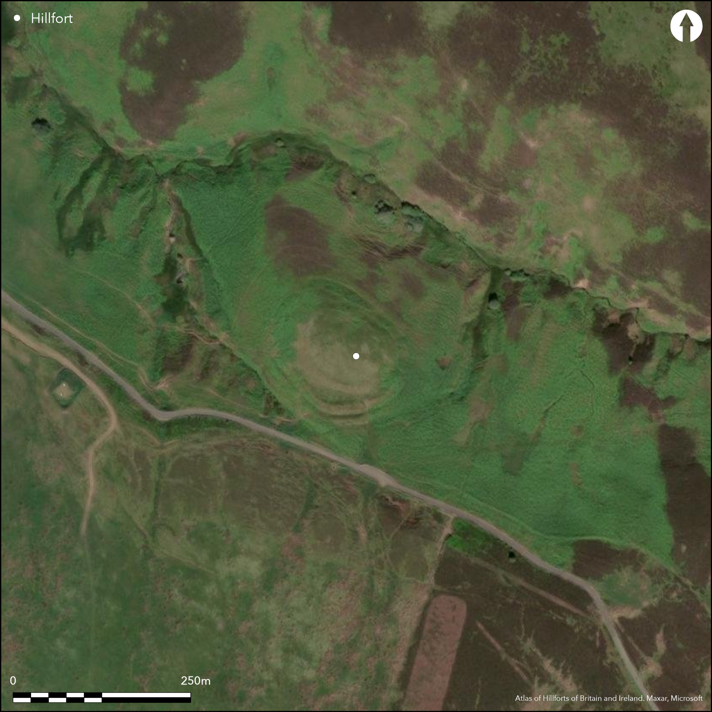
This fort, which is situated on a hillock in a cleft in the Lammermuir escarpment immediately NW of the minor road crossing from Garvald into the valley of the Whiteadder Water, commands extensive views out over the Lothian Plain to the NW. Oval on plan, its defences comprise two main elements, an inner oval enclosure with a single rampart and ditch, encircled by a slightly eccentric outer pair of ramparts with a medial ditch. The inner enclosure measures internally about 70m from NW to SE by 51m transversely (0.28ha), its rampart forming a low mound to either side of the entrance on the SW but elsewhere reduced to little more than a scarp dropping some 2.4m to traces of an external ditch; evaluation excavations 2010-13 showed that on the steep NE flank the crest-line of the rampart covered a row of timber posts. Entrances are visible on the SE, SW and NW, in each case corresponding to gaps in the outer defences, which enclose an area measuring 95m from NW to SE by 73m transversely (0.6ha). The most recent topographical survey during the recent evaluations has identified no fewer than eighteen platforms within the interior. On the strength of ten radiocarbon dates from a range of contexts, the excavators (Cook and Connolly 2013, 25-7) argue for three broad phases in which the eccentric and short-lived inner rampart was inserted into an earlier enclosure about 400 BC, but that the platforms represent ongoing occupation possibly as late as the beginning of the 2nd century BC; a single radiocarbon date from the outermost rampart falls in this last phase.
Citizen Science: ✗
Reliability of Data: Confirmed
Reliability of Interpretation: Confirmed
X: -291637 Y: 7540318 (EPSG: 3857)
Longitude: -2.6198219532066145 Latitude: 55.90898494882293 (EPSG:4326)
Country: Scotland
Current County or Unitary Authority: East Lothian
Historic County: East Lothian
Current Parish/Community/Council/Townland: Garvald And Bara
None
| Extant | ✓ |
| Cropmark | ✗ |
| Likely Destroyed | ✗ |
None
| Woodland | ✗ |
| Commercial Forestry Plantation | ✗ |
| Parkland | ✗ |
| Pasture (Grazing) | ✓ |
| Arable | ✗ |
| Scrub/Bracken | ✗ |
| Bare Outcrop | ✗ |
| Heather/Moorland | ✓ |
| Heath | ✗ |
| Built-up | ✗ |
| Coastal Grassland | ✗ |
| Other | ✗ |
None
| Contour Fort | ✓ |
| Partial Contour Fort | ✗ |
| Promontory Fort | ✗ |
| Hillslope Fort | ✗ |
| Level Terrain Fort | ✗ |
| Marsh Fort | ✗ |
| Multiple Enclosure Fort | ✗ |
| Hilltop | ✗ |
| Coastal Promontory | ✗ |
| Inland Promontory | ✗ |
| Valley Bottom | ✗ |
| Knoll/Hillock/Outcrop | ✓ |
| Ridge | ✗ |
| Cliff/Plateau-edge/Scarp | ✗ |
| Hillslope | ✗ |
| Lowland | ✗ |
| Spur | ✗ |
Dominant Topographic Feature: None
| North | ✗ |
| Northeast | ✗ |
| East | ✗ |
| Southeast | ✗ |
| South | ✗ |
| Southwest | ✗ |
| West | ✗ |
| Northwest | ✗ |
| Level | ✓ |
Altitude: 318.0m
N/A
The excavators argue (Cook and Connolly 2013, 25-7) that the bulk of the activity occurs about 400 BC, with the construction of a short-lived inner rampart within a slightly earlier and large enclosure, and that the platforms visible within the interior represent ongoing settlement until the beginning of the 2nd century BC; the outermost rampart apparently belongs to this later phase.
Reliability: C - Low
| Pre 1200BC | ✗ |
| 1200BC - 800BC | ✗ |
| 800BC - 400BC | ✓ |
| 400BC - AD50 | ✓ |
| AD50 - AD400 | ✗ |
| AD400 - AD 800 | ✗ |
| Post AD800 | ✗ |
| Unknown | ✗ |
| Pre Hillfort: | None |
| Post Hillfort: | None |
| C14: | Ten radiocarbon dates from a range of contexts |
Range of aerial photographs under various conditions by John Dewar (held by RCAHMS) and the RCAHMS Aerial Survey Programme
| 1st Identified Map Depiction (1799): | Annotated on William Forrest's Map of Haddingtonshire (1799) |
| Other (1853): | Annotated 'British Fort' on the 1st edition OS 6-inch map (Haddingtonshire 1855, sheet 16) |
| Other (1892): | Depicted on the OS 25-inch map (Haddingtonshire 1894, sheet 16.3) |
| Earthwork Survey (1913): | Plan and description (RCAHMS 1924, 35-6, no.52, fig 71) |
| Other (1923): | Scheduled |
| Other (1954): | Description during RCAHMS Survey of Marginal Lands (Feachem 1963, 123) |
| Other (1961): | Re-Scheduled |
| Other (1968): | Resurveyed at 1:2500 by the OS |
| Excavation (2010): | Evaluation by Murray Cook and David Connolly (Cook et al 2010) |
| Excavation (2011): | Evaluation by Murray Cook and David Connolly (Cook and Connolly 2011; 2012) |
| Excavation (2012): | Evaluation by Murray Cook and David Connolly (Cook and Connolly 2013) |
| Geophysical Survey (2012): | Carried out in the course of excavations by the Edinburgh Archaeological Field Society (Cook and Connolly 2013, 18, fig 5) |
| Excavation (2013): | Evaluation by Murray Cook and David Connolly (Cook and Connolly 2014; Cook 2013) |
| Earthwork Survey (2013): | Contour plan generated in the course of the excavations (Cook and Connelly 2014, 3, fig 2) |
Eighteen platforms have been from 3.5m to 9m in diameter have been identified within the interior, Evaluation on one suggests medieval occupation while a small rectangular structure tucked into the back of the innermost rampart dates from the 15th - 17th centuries; the site may have provided a convenient location from which to exploit the hill grazings.
None
| None | ✓ |
| Spring | ✗ |
| Stream | ✗ |
| Pool | ✗ |
| Flush | ✗ |
| Well | ✗ |
| Other | ✗ |
Eighteen platforms and one square structure of later date
| No Known Features | ✗ |
| Round Stone Structures | ✗ |
| Rectangular Stone Structures | ✓ |
| Curvilinear Platforms | ✓ |
| Other Roundhouse Evidence | ✗ |
| Pits | ✗ |
| Quarry Hollows | ✗ |
| Other | ✗ |
No more than evaluation trenches
| No Known Excavation | ✗ |
| Pits | ✓ |
| Postholes | ✓ |
| Roundhouses | ✗ |
| Rectangular Structures | ✗ |
| Roads/Tracks | ✗ |
| Quarry Hollows | ✗ |
| Other | ✗ |
| Nothing Found | ✗ |
No clearly resolved structures
| No Known Geophysics | ✗ |
| Pits | ✗ |
| Roundhouses | ✗ |
| Rectangular Structures | ✗ |
| Roads/Tracks | ✗ |
| Quarry Hollows | ✗ |
| Other | ✓ |
| Nothing Found | ✗ |
Small assemblage of coarse stone objects, including a small slab bearing faint incised lines, three sherds of coarse pottery, occasional pieces of flint, and possible fragments of quernstones
| No Known Finds | ✗ |
| Pottery | ✓ |
| Metal | ✗ |
| Metalworking | ✗ |
| Human Bones | ✗ |
| Animal Bones | ✗ |
| Lithics | ✓ |
| Environmental | ✗ |
| Other | ✗ |
None
| APs Not Checked | ✗ |
| None | ✗ |
| Roundhouses | ✓ |
| Rectangular Structures | ✗ |
| Pits | ✗ |
| Postholes | ✗ |
| Roads/Tracks | ✗ |
| Other | ✗ |
See main summary
| 3: | None |
| 2: | Piercing all ramparts |
Guard Chambers: ✗
Chevaux de Frise: ✗
| 1. Simple Gap (South east): | None |
| 2. Simple Gap (South west): | None |
| 3. Simple Gap (North west): | None |
Three ramparts, representing at least two phases, in which the inner accompanied by an external ditch is inserted into an earlier enclosure with twin ramparts and a medial ditch
| Area 1: | 0.28ha. |
| Area 2: | 0.6ha. |
| Total: | 0.6ha. |
Total Footprint Area: 0.98ha.
None
| ✓ | The eccentricity of the inner and outer circuits suggests they are of separate dates |
| ✓ | None |
| NE Quadrant: | 3 |
| SE Quadrant: | 3 |
| SW Quadrant: | 3 |
| NW Quadrant: | 2 |
| Total: | 3 |
| Partial Univallate | ✗ |
| Univallate | ✗ |
| Partial Bivallate | ✓ |
| Bivallate | ✗ |
| Partial Multivallate | ✓ |
| Multivallate | ✗ |
| Unknown | ✗ |
| Partial Univallate | ✗ |
| Univallate | ✗ |
| Partial Bivallate | ✗ |
| Bivallate | ✓ |
| Partial Multivallate | ✗ |
| Multivallate | ✗ |
None
| None | ✗ |
| Earthen Bank | ✓ |
| Stone Wall | ✗ |
| Rubble | ✗ |
| Wall-walk | ✗ |
| Evidence of Timber | ✗ |
| Vitrification | ✗ |
| Other Burning | ✗ |
| Palisade | ✗ |
| Counter Scarp Bank | ✗ |
| Berm | ✗ |
| Unfinished | ✗ |
| Other | ✗ |
None
| None | ✗ |
| Earthen Bank | ✓ |
| Stone Wall | ✗ |
| Murus Duplex | ✗ |
| Timber-framed | ✗ |
| Timber-laced | ✗ |
| Vitrification | ✗ |
| Other Burning | ✗ |
| Palisade | ✓ |
| Counter Scarp Bank | ✗ |
| Berm | ✗ |
| Unfinished | ✗ |
| No Known Excavation | ✗ |
| Other | ✗ |
| ✗ | None |
| ✓ | There is possibly a third ditch on the S but it may equally be a combination of natural features and a trackway |
Number of Ditches: 2
| ✗ | None |
Cook, M (2014) 'Garvald and Bara, White Castle Season 4, Excavation and survey'. Disc Exc Scot, New Ser, 14 (2013), 69-70
Cook, M, and Connolly, D (2010) 'White Castle Season 1, East Lothian (Garvald and Bara parish), survey and excavation'. Disc Exc Scot, New Ser, 11 (2010), 59-60
Cook, M, and Connolly, D (2011) 'White Castle Season 2, East Lothian (Garvald and Bara parish), survey and excavation'. Disc Exc Scot, New Ser, 12 (2011), 64
Cook, M, and Connolly, D (2012) Rampart Scotland Project 001: The Hillforts of East Lothian Season 2. White Castle, Garvald, East Lothian Data Structure Report and Post Excavation Assessment. Unpublished report https://www.rampartscotland.co.uk/index.php/publications/
Cook, M, and Connolly, D (2013) Rampart Scotland Project 001: The Hillforts of East Lothian Season 3. White Castle, Garvald, East Lothian, Data Structure Report. Unpublished report https://www.rampartscotland.co.uk/index.php/publications/
Cook, M, and Connolly, D (2014) Rampart Scotland Project 001: The Hillforts of East Lothian Season 4. White Castle, Garvald, East Lothian, Data Structure Report. Unpublished report https://www.rampartscotland.co.uk/index.php/publications/
Cook, M, Connolly, D and Kdolska, H (2010) Rampart Scotland Project 001: The Hillforts of East Lothian Season 3. White Castle, Garvald, East Lothian: Data Structure Report and Costed Post Excavation Research Design. Unpublished report https://www.rampartscotland.co.uk/index.php/publications/
Feachem, R (1963) A guide to prehistoric Scotland. London: Batsford
RCAHMS (1924) The Royal Commission on the Ancient and Historical Monuments and Constructions of Scotland. Eighth report with Inventory of Monuments and Constructions in the County of East Lothian. HMSO: Edinburgh
Atlas of Hillforts:
Wikidata:
This work is licensed under CC BY-SA 4.0![]()
![]()
![]() and should be cited as:
and should be cited as:
Lock, Gary and Ralston, Ian. 2024. Atlas of Hillforts of Britain and Ireland. Available at: https://hillforts.arch.ox.ac.uk
Document Version 1.1