LiDAR 1m DTM Hillshade

Satellite Imagery
LiDAR 1m DTM Hillshade
Satellite Imagery
Scroll left/right to view further images.
HER: East Lothian Council MEL1422 (None)
NMR: NT 66 SE 1 (57509)
SM: 748
NGR: NT 6645 6315
X: 366450 Y: 663150 (OSGB36)
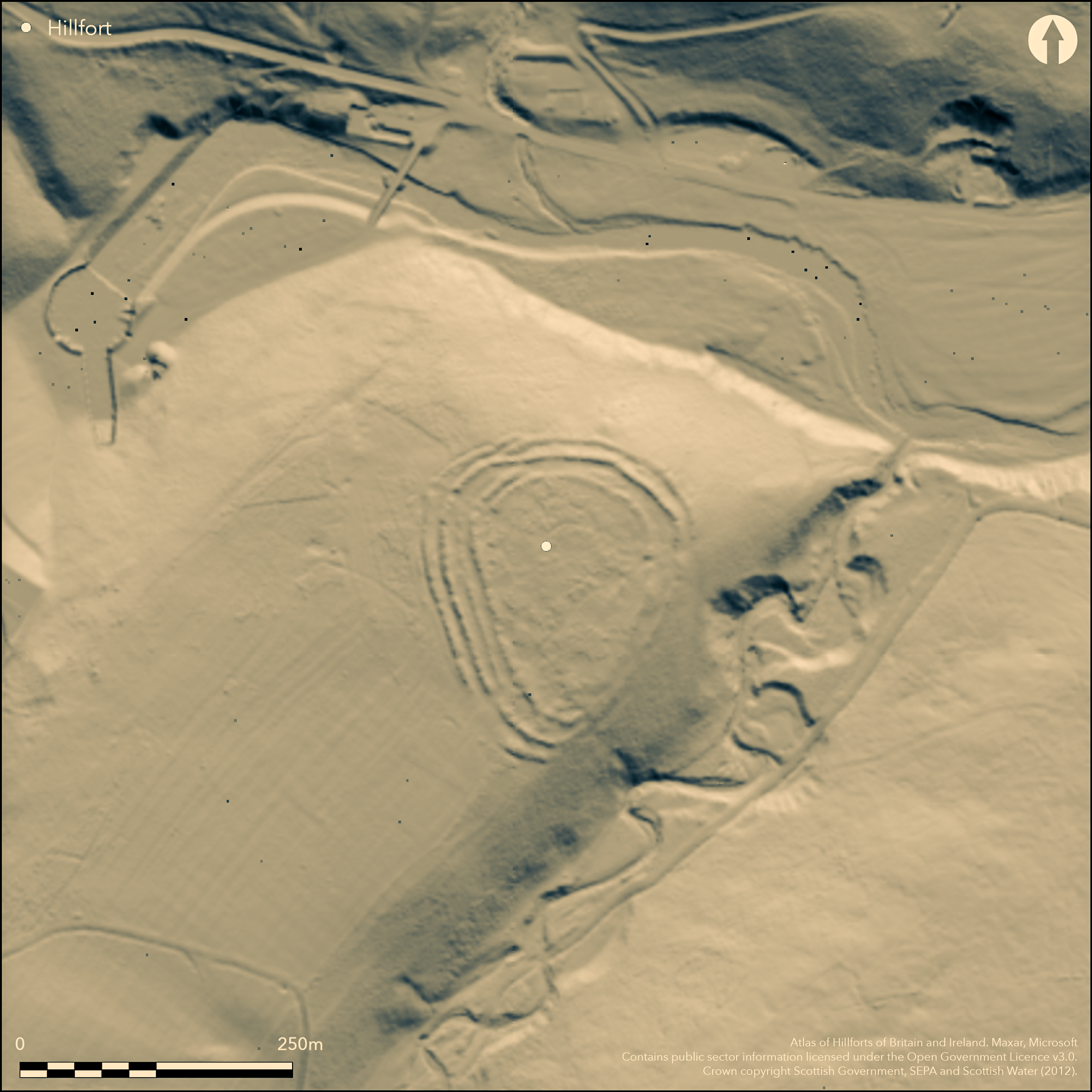
This fort, which occupies the tip of a spur projecting from the foot of the NE flank of Priestlaw Hill, overlooks the S bank of the Whiteadder Water where it debouches from the dam of the Whiteadder Reservoir. Pear-shaped on plan, its defences comprise a belt of up to four ramparts with external ditches cutting across the neck of the spur on the W, but reducing to three ramparts on the N flank above the Whiteadder, and two on the E above the gully of the Kilmade Burn. Close examination, however, shows that this configuration of the defences is the later of two schemes, which has been superimposed eccentrically across an earlier scheme on the N and W. The present circuit of the innermost rampart encloses an area measuring 125m from N to S by a maximum of 87m transversely towards the N end (0.78ha), and belongs largely to the later scheme, though it almost certainly subsumes the line of the earlier inner rampart on the W; indeed the only visible evidence of the latter is on the N side of the entrance on the NW, where the construction of the new inner rampart inside its line to elaborate the entrance passage has allowed a short fragment to survive. In this earlier phase the defences probably included the second rampart on the W, but this and the fragment of inner rampart are truncated where the third rampart on the W swings round onto the N flank, probably to adopt the original line of the inner rampart on the lip of the slope dropping down to the Whiteadder. It is unclear whether the earlier defences continued along the edge of the gully above the Kilmade Burn on the E flank or whether it was essentially a promontory enclosure in this phase, but the interior was certainly larger and may have extended to as much as 0.94ha. The outermost rampart on the W should probably be attributed to the later scheme, which was essentially trivallate, only reducing to two ramparts on the E, and was served by entrances on the NE, SW and NW, though opinion in the various accounts conflicts as to whether there is a gap through the innermost rampart on the SW. The NE and NW entrances show some elaboration: at the the former the gaps are staggered to create an oblique approach that exposes the visitor's right side, while at the latter the terminals of the inner rampart overlap, creating a sharp right turn at the inner end of the entrance way, in this case exposing the visitor's left side. The plan drawn up by RCAHMS investigators in 1920 (RCAHMS 1924, 136, no.218, fig 178) shows twenty-four possible structures within the interior, but these were largely dismissed by their successors visiting in 1954, who could find only two stone-founded round-houses.
Citizen Science: ✗
Reliability of Data: Confirmed
Reliability of Interpretation: Confirmed
X: -282481 Y: 7530676 (EPSG: 3857)
Longitude: -2.537567937896721 Latitude: 55.86040218393775 (EPSG:4326)
Country: Scotland
Current County or Unitary Authority: East Lothian
Historic County: East Lothian
Current Parish/Community/Council/Townland: Whittingehame
None
| Extant | ✓ |
| Cropmark | ✗ |
| Likely Destroyed | ✗ |
Bracken renders reading of interior difficult
| Woodland | ✗ |
| Commercial Forestry Plantation | ✗ |
| Parkland | ✗ |
| Pasture (Grazing) | ✓ |
| Arable | ✗ |
| Scrub/Bracken | ✓ |
| Bare Outcrop | ✗ |
| Heather/Moorland | ✓ |
| Heath | ✗ |
| Built-up | ✗ |
| Coastal Grassland | ✗ |
| Other | ✗ |
None
| Contour Fort | ✓ |
| Partial Contour Fort | ✗ |
| Promontory Fort | ✗ |
| Hillslope Fort | ✗ |
| Level Terrain Fort | ✗ |
| Marsh Fort | ✗ |
| Multiple Enclosure Fort | ✗ |
| Hilltop | ✗ |
| Coastal Promontory | ✗ |
| Inland Promontory | ✓ |
| Valley Bottom | ✗ |
| Knoll/Hillock/Outcrop | ✗ |
| Ridge | ✗ |
| Cliff/Plateau-edge/Scarp | ✗ |
| Hillslope | ✗ |
| Lowland | ✗ |
| Spur | ✓ |
Dominant Topographic Feature: None
| North | ✗ |
| Northeast | ✗ |
| East | ✗ |
| Southeast | ✗ |
| South | ✗ |
| Southwest | ✗ |
| West | ✗ |
| Northwest | ✗ |
| Level | ✓ |
Altitude: 257.0m
N/A
In the absence of excavation, there are neither stratified artefacts nor radiocarbon dates to provide a chronology for the defences.
Reliability: D - None
| Pre 1200BC | ✗ |
| 1200BC - 800BC | ✗ |
| 800BC - 400BC | ✗ |
| 400BC - AD50 | ✗ |
| AD50 - AD400 | ✗ |
| AD400 - AD 800 | ✗ |
| Post AD800 | ✗ |
| Unknown | ✓ |
| Pre Hillfort: | None |
| Post Hillfort: | At least two stone-founded round-houses within the interior are likely to relate to a post defensive late Iron Age occupation |
Photographed by John Dewar in 1971 (held by RCAHMS) and RCAHMS Aerial Survey Programme in 1980, 1986, 1988, 1993 and 2007
| 1st Identified Map Depiction (1773): | Flattened concentric ring symbol reflecting actual shape on Andrew and Mostyn Armstrong's Map of the three Lothians (1773) |
| Other (1792): | Description (Stat Acct, ii, 1792, 346-7) |
| Other (1853): | Annotated Fort on the 1st edition OS 6-inch map (Haddingtonshire 1854, sheet 20) |
| Other (1892): | Depicted on the OS 25-inch map (Haddingtonshire 1894, sheet 16.16 |
| Earthwork Survey (1910): | By James Hewat Craw (1911, opp207) |
| Earthwork Survey (1920): | Plan and description (RCAHMS 1924, 136, no.218, fig 178; RCAHMS ELD 10/1-5) |
| Other (1923): | Scheduled |
| Earthwork Survey (1954): | Schematic sketch-plan and description during RCAHMS Survey of Marginal Lands (Feachem 1963, 123) |
| Other (1966): | Visited by the OS |
| Other (1969): | Re-Scheduled |
At least two stone founded round-houses, but in 1954 RCAHMS investigators dismissed all the other features shown by their predecessors on a plan of 1920
None
| None | ✓ |
| Spring | ✗ |
| Stream | ✗ |
| Pool | ✗ |
| Flush | ✗ |
| Well | ✗ |
| Other | ✗ |
At least two
| No Known Features | ✗ |
| Round Stone Structures | ✓ |
| Rectangular Stone Structures | ✗ |
| Curvilinear Platforms | ✗ |
| Other Roundhouse Evidence | ✗ |
| Pits | ✗ |
| Quarry Hollows | ✗ |
| Other | ✗ |
None
| No Known Excavation | ✓ |
| Pits | ✗ |
| Postholes | ✗ |
| Roundhouses | ✗ |
| Rectangular Structures | ✗ |
| Roads/Tracks | ✗ |
| Quarry Hollows | ✗ |
| Other | ✗ |
| Nothing Found | ✗ |
None
| No Known Geophysics | ✓ |
| Pits | ✗ |
| Roundhouses | ✗ |
| Rectangular Structures | ✗ |
| Roads/Tracks | ✗ |
| Quarry Hollows | ✗ |
| Other | ✗ |
| Nothing Found | ✗ |
None
| No Known Finds | ✓ |
| Pottery | ✗ |
| Metal | ✗ |
| Metalworking | ✗ |
| Human Bones | ✗ |
| Animal Bones | ✗ |
| Lithics | ✗ |
| Environmental | ✗ |
| Other | ✗ |
At least one of the round-houses can be distinguished
| APs Not Checked | ✗ |
| None | ✗ |
| Roundhouses | ✓ |
| Rectangular Structures | ✗ |
| Pits | ✗ |
| Postholes | ✗ |
| Roads/Tracks | ✗ |
| Other | ✗ |
See main summary
| 3: | None |
| 2: | None |
Guard Chambers: ✗
Chevaux de Frise: ✗
| 1. Simple Gap (North east): | Piercing two ramparts belonging to the later phase of the defences |
| 2. Simple Gap (South west): | Apparently pierces the outer lines, but various authorities disagree as to whether there is a gap in the innermost rampart. |
| 3. Over-lapping (North west): | The reconstruction of the defensive system has created an overlap in the innermost rampart, forcing the visitor approaching along the entrance way at right-angles to the general axis of the ramparts to turn right through the gap in the innermost to exposing left side. |
| 3. Simple Gap (North west): | With opposed terminals in the outer ramparts |
With up to four ramparts and ditches across the neck of the spur, and two or three elsewhere, the defences are clearly a composite design representing at least two periods of construction
| Area 1: | 0.93ha. |
| Area 2: | 0.74ha. |
| Total: | 0.93ha. |
Total Footprint Area: 1.7ha.
None
| ✓ | On the NW, the third rampart on the W clearly cuts across the line of the second rampart, also truncating the earlier line of the inner rampart |
| ✓ | None |
| NE Quadrant: | 3 |
| SE Quadrant: | 2 |
| SW Quadrant: | 4 |
| NW Quadrant: | 4 |
| Total: | 4 |
| Partial Univallate | ✗ |
| Univallate | ✗ |
| Partial Bivallate | ✓ |
| Bivallate | ✗ |
| Partial Multivallate | ✓ |
| Multivallate | ✗ |
| Unknown | ✗ |
| Partial Univallate | ✗ |
| Univallate | ✗ |
| Partial Bivallate | ✓ |
| Bivallate | ✗ |
| Partial Multivallate | ✗ |
| Multivallate | ✗ |
None
| None | ✗ |
| Earthen Bank | ✓ |
| Stone Wall | ✗ |
| Rubble | ✗ |
| Wall-walk | ✗ |
| Evidence of Timber | ✗ |
| Vitrification | ✗ |
| Other Burning | ✗ |
| Palisade | ✗ |
| Counter Scarp Bank | ✗ |
| Berm | ✗ |
| Unfinished | ✗ |
| Other | ✗ |
None
| None | ✗ |
| Earthen Bank | ✗ |
| Stone Wall | ✗ |
| Murus Duplex | ✗ |
| Timber-framed | ✗ |
| Timber-laced | ✗ |
| Vitrification | ✗ |
| Other Burning | ✗ |
| Palisade | ✗ |
| Counter Scarp Bank | ✗ |
| Berm | ✗ |
| Unfinished | ✗ |
| No Known Excavation | ✓ |
| Other | ✗ |
| ✗ | None |
| ✓ | At least three and possibly four, but representing several periods of construction |
Number of Ditches: 3
| ✗ | None |
Craw, J H (1911) «Fort and hut-circles on Whitadder». Hist Berwickshire Natur Club 21 (1909-11), 206-10
Feachem, R W (1963) A guide to prehistoric Scotland. Batsford: London
RCAHMS (1924) The Royal Commission on the Ancient and Historical Monuments and Constructions of Scotland. Eighth report with Inventory of Monuments and Constructions in the County of East Lothian. HMSO: Edinburgh
Stat Acct (date) Statistical Account of Scotland: Drawn up from the Communications of the Ministers of the Different Parishes (Sinclair, J ed), 1791-99
Atlas of Hillforts:
Wikidata:
This work is licensed under CC BY-SA 4.0![]()
![]()
![]() and should be cited as:
and should be cited as:
Lock, Gary and Ralston, Ian. 2024. Atlas of Hillforts of Britain and Ireland. Available at: https://hillforts.arch.ox.ac.uk
Document Version 1.1