LiDAR 1m DTM Hillshade

Satellite Imagery
LiDAR 1m DTM Hillshade
Satellite Imagery
Scroll left/right to view further images.
HER: East Lothian Council MEL1558 (None)
NMR: NT 67 NE 60 (57665)
SM: 5764
NGR: NT 6834 7552
X: 368340 Y: 675520 (OSGB36)
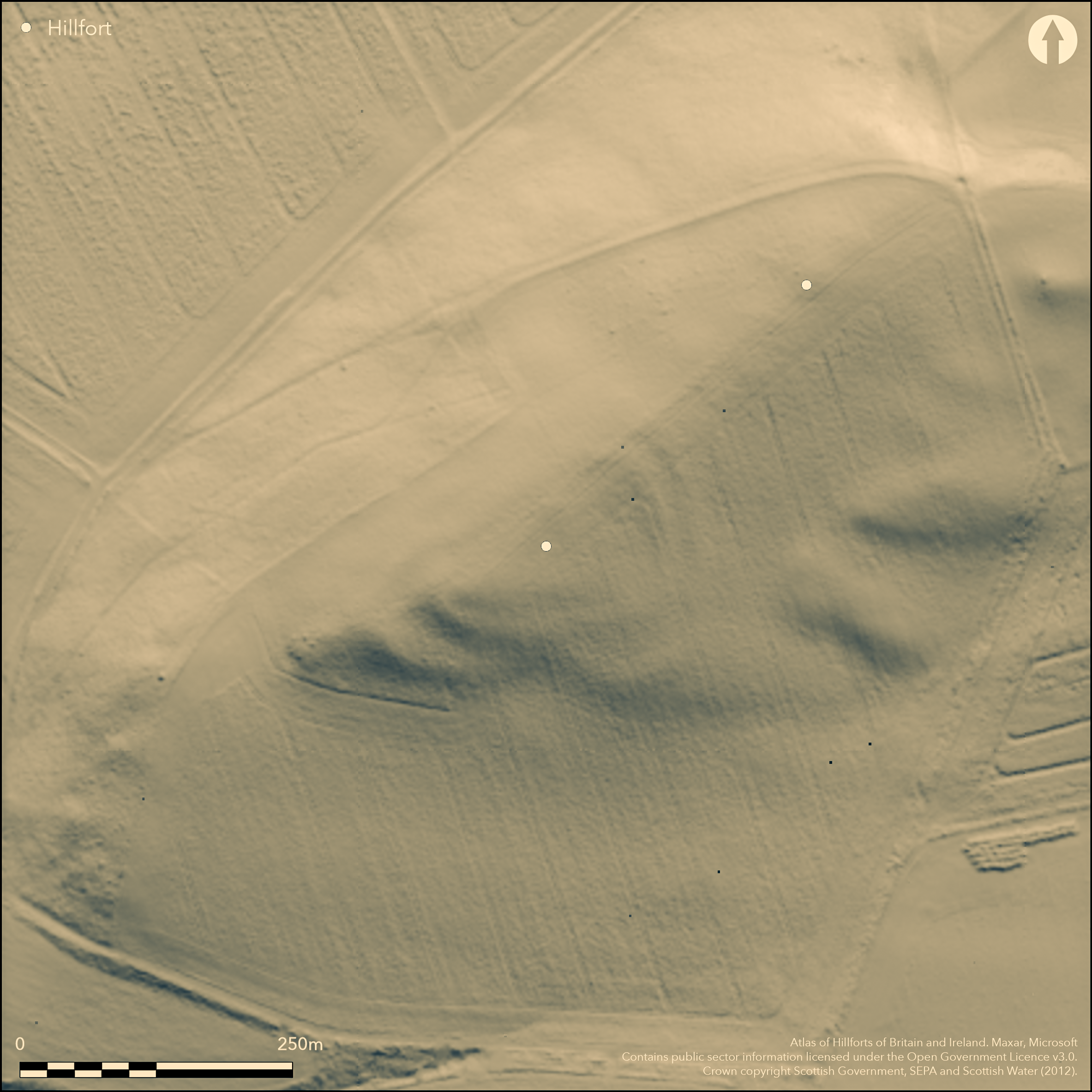
This fort, one of two on Doon Hill (see Atlans No.3910), is situated on the WSW end of the elongated summit overlooking Spott House, and though its ramparts and ditches have been heavily ploughed down, traces of two of them are still visible as undulations in the surface of the field, cutting across the crest of the hill on the ENE to turn sharply along the S flank, and almost certainly returning along the edge of the steep escarpment falling away on the NW. Thus defined, the fort is pear-shaped on plan, tapering towards the WSW, and measures internally some 120m from ENE to WSW by a maximum of 75m transversely (0.75ha). The cropmarks, however, suggest a more complex configuration, with no fewer than three ditches crossing the crest of the hill and turning onto the S flank, though the markings are too diffuse in this sector to correlate them precisely with the standing remains of the ramparts, and are further confused by what is probably an internal quarry scoop to the rear of the rampart elsewhere on the S. In addition, photographs taken in 1984 show two possible palisade trenches concentrically outside the outer ditch on the ENE, the outer intersecting the outermost palisade of the adjacent fort, and though they cannot be traced along the southern flank, other trenches can probably be detected amongst the markings at the WSW tip of the fort. In this same year, the arc of yet another palisade trench was photographed cutting across the WSW end of the interior, with two post-holes flanking an entrance on the NE. No other features have been detected within the interior, and only one entrance is certainly visible, marked by a deep re-entrant in the line of the outer rampart on the S; apparently elaborate, exploiting a natural hollow in the hillside, the cropmarks are too diffuse to resolve the details of its plan. This entrance was not noted by the RCAHMS investigators who visited in 1913, and they suggested the entrance was on the NW, apparently marked by a gap in the defences some 9m in breadth.
Citizen Science: ✗
Reliability of Data: Confirmed
Reliability of Interpretation: Confirmed
X: -279281 Y: 7552778 (EPSG: 3857)
Longitude: -2.508827631260379 Latitude: 55.971670267749914 (EPSG:4326)
Country: Scotland
Current County or Unitary Authority: East Lothian
Historic County: East Lothian
Current Parish/Community/Council/Townland: Spott
None
| Extant | ✓ |
| Cropmark | ✓ |
| Likely Destroyed | ✗ |
None
| Woodland | ✗ |
| Commercial Forestry Plantation | ✗ |
| Parkland | ✗ |
| Pasture (Grazing) | ✓ |
| Arable | ✓ |
| Scrub/Bracken | ✗ |
| Bare Outcrop | ✗ |
| Heather/Moorland | ✗ |
| Heath | ✗ |
| Built-up | ✗ |
| Coastal Grassland | ✗ |
| Other | ✗ |
None
| Contour Fort | ✓ |
| Partial Contour Fort | ✗ |
| Promontory Fort | ✗ |
| Hillslope Fort | ✗ |
| Level Terrain Fort | ✗ |
| Marsh Fort | ✗ |
| Multiple Enclosure Fort | ✗ |
| Hilltop | ✓ |
| Coastal Promontory | ✗ |
| Inland Promontory | ✗ |
| Valley Bottom | ✗ |
| Knoll/Hillock/Outcrop | ✗ |
| Ridge | ✗ |
| Cliff/Plateau-edge/Scarp | ✗ |
| Hillslope | ✗ |
| Lowland | ✗ |
| Spur | ✗ |
Dominant Topographic Feature: None
| North | ✗ |
| Northeast | ✗ |
| East | ✗ |
| Southeast | ✗ |
| South | ✗ |
| Southwest | ✗ |
| West | ✗ |
| Northwest | ✗ |
| Level | ✓ |
Altitude: 167.0m
N/A
In the absence of excavation, there are neither stratified artefacts nor radiocarbon dates to provide a chronology for the defences.
Reliability: D - None
| Pre 1200BC | ✗ |
| 1200BC - 800BC | ✗ |
| 800BC - 400BC | ✗ |
| 400BC - AD50 | ✗ |
| AD50 - AD400 | ✗ |
| AD400 - AD 800 | ✗ |
| Post AD800 | ✗ |
| Unknown | ✓ |
| Pre Hillfort: | None |
| Post Hillfort: | Ploughed down and traditionally part of the site of General Leslie's camp prior to the defeat of the Covenanter army by Parliamentary forces at the Battle of Dunbar in 1650 (Name Book, Haddingtonshire, No.35, p 15) |
Photographed by CUCAP in 1959 and 1977, and by RCAHMS Aerial Survey Programme in 1976, 1983, 1984, 1992, 1996, 2000, 2013, 2014 and 2015
| 1st Identified Map Depiction (1773): | Concentric ring on the slope of the hill on Andrew and Mostyn Armstrong's Map of the three Lothians (1773) |
| Other (1853): | Annotated Fort on the 1st edition OS 6-inch map (Haddingtonshire 1855, sheet 11), but evidently already ploughed down and depicted as three concentric dashed circles |
| Other (1913): | Description (RCAHMS 1924, 108, no.166) |
| Other (1954): | Description during RCAHMS Survey of Marginal Lands |
| Other (1966): | Resurveyed at 1:2500 by the OS |
| Other (1993): | Scheduled |
Internal palisaded enclosure, probably circular or oval, occupying the W tip of the hill
None
| None | ✓ |
| Spring | ✗ |
| Stream | ✗ |
| Pool | ✗ |
| Flush | ✗ |
| Well | ✗ |
| Other | ✗ |
None
| No Known Features | ✓ |
| Round Stone Structures | ✗ |
| Rectangular Stone Structures | ✗ |
| Curvilinear Platforms | ✗ |
| Other Roundhouse Evidence | ✗ |
| Pits | ✗ |
| Quarry Hollows | ✗ |
| Other | ✗ |
None
| No Known Excavation | ✓ |
| Pits | ✗ |
| Postholes | ✗ |
| Roundhouses | ✗ |
| Rectangular Structures | ✗ |
| Roads/Tracks | ✗ |
| Quarry Hollows | ✗ |
| Other | ✗ |
| Nothing Found | ✗ |
None
| No Known Geophysics | ✓ |
| Pits | ✗ |
| Roundhouses | ✗ |
| Rectangular Structures | ✗ |
| Roads/Tracks | ✗ |
| Quarry Hollows | ✗ |
| Other | ✗ |
| Nothing Found | ✗ |
None
| No Known Finds | ✓ |
| Pottery | ✗ |
| Metal | ✗ |
| Metalworking | ✗ |
| Human Bones | ✗ |
| Animal Bones | ✗ |
| Lithics | ✗ |
| Environmental | ✗ |
| Other | ✗ |
Circular or oval palisaded enclosure. Probable quarry scoops to the rear of the inner rampart
| APs Not Checked | ✗ |
| None | ✗ |
| Roundhouses | ✗ |
| Rectangular Structures | ✗ |
| Pits | ✗ |
| Postholes | ✗ |
| Roads/Tracks | ✗ |
| Other | ✓ |
See main summary
| 2: | The whole circuit is ploughed down |
| 2: | None |
Guard Chambers: ✗
Chevaux de Frise: ✗
| 1. Oblique (South): | Clearly an elaborate entrance, with an oblique approach exposing the visitor's left side, and potentially with inturned or staggered rampart terminals to either side, but the detailed plan is unclear |
| 2. Simple Gap (North west): | A gap observed in 1913 but unsubstantiated by later work |
At least two ramparts with ditches, but the cropmarks reveal a third ditch on the ENE
| Area 1: | 0.75ha. |
| Total: | 0.75ha. |
Total Footprint Area: 2.2ha.
None
| ✗ | None |
| ✓ | None |
| NE Quadrant: | 2 |
| SE Quadrant: | 3 |
| SW Quadrant: | 2 |
| NW Quadrant: | 2 |
| Total: | 3 |
| Partial Univallate | ✗ |
| Univallate | ✗ |
| Partial Bivallate | ✓ |
| Bivallate | ✗ |
| Partial Multivallate | ✓ |
| Multivallate | ✗ |
| Unknown | ✗ |
| Partial Univallate | ✗ |
| Univallate | ✗ |
| Partial Bivallate | ✗ |
| Bivallate | ✗ |
| Partial Multivallate | ✗ |
| Multivallate | ✗ |
Ploughed down traces of the earthworks are still visible and cropmarks reveal two external palisade trenches on the ENE
| None | ✗ |
| Earthen Bank | ✓ |
| Stone Wall | ✗ |
| Rubble | ✗ |
| Wall-walk | ✗ |
| Evidence of Timber | ✗ |
| Vitrification | ✗ |
| Other Burning | ✗ |
| Palisade | ✓ |
| Counter Scarp Bank | ✗ |
| Berm | ✗ |
| Unfinished | ✗ |
| Other | ✗ |
None
| None | ✗ |
| Earthen Bank | ✗ |
| Stone Wall | ✗ |
| Murus Duplex | ✗ |
| Timber-framed | ✗ |
| Timber-laced | ✗ |
| Vitrification | ✗ |
| Other Burning | ✗ |
| Palisade | ✗ |
| Counter Scarp Bank | ✗ |
| Berm | ✗ |
| Unfinished | ✗ |
| No Known Excavation | ✓ |
| Other | ✗ |
| ✗ | None |
| ✓ | None |
Number of Ditches: 3
| ✗ | None |
Name Book, Ordnance Survey Object Name Books (6 inch and 1/2500 scale); available https://www.scotlandsplaces.gov.uk/
RCAHMS (1924) The Royal Commission on the Ancient and Historical Monuments and Constructions of Scotland. Eighth report with Inventory of Monuments and Constructions in the County of East Lothian. HMSO: Edinburgh
Atlas of Hillforts:
Wikidata:
This work is licensed under CC BY-SA 4.0![]()
![]()
![]() and should be cited as:
and should be cited as:
Lock, Gary and Ralston, Ian. 2024. Atlas of Hillforts of Britain and Ireland. Available at: https://hillforts.arch.ox.ac.uk
Document Version 1.1