LiDAR 1m DTM Hillshade
Satellite Imagery
LiDAR 1m DTM Hillshade
Satellite Imagery
Scroll left/right to view further images.
HER: East Lothian Council MEL1683 (None)
NMR: NT 67 SE 2 (57792)
SM: 5766
NGR: NT 6599 7393
X: 365991 Y: 673933 (OSGB36)
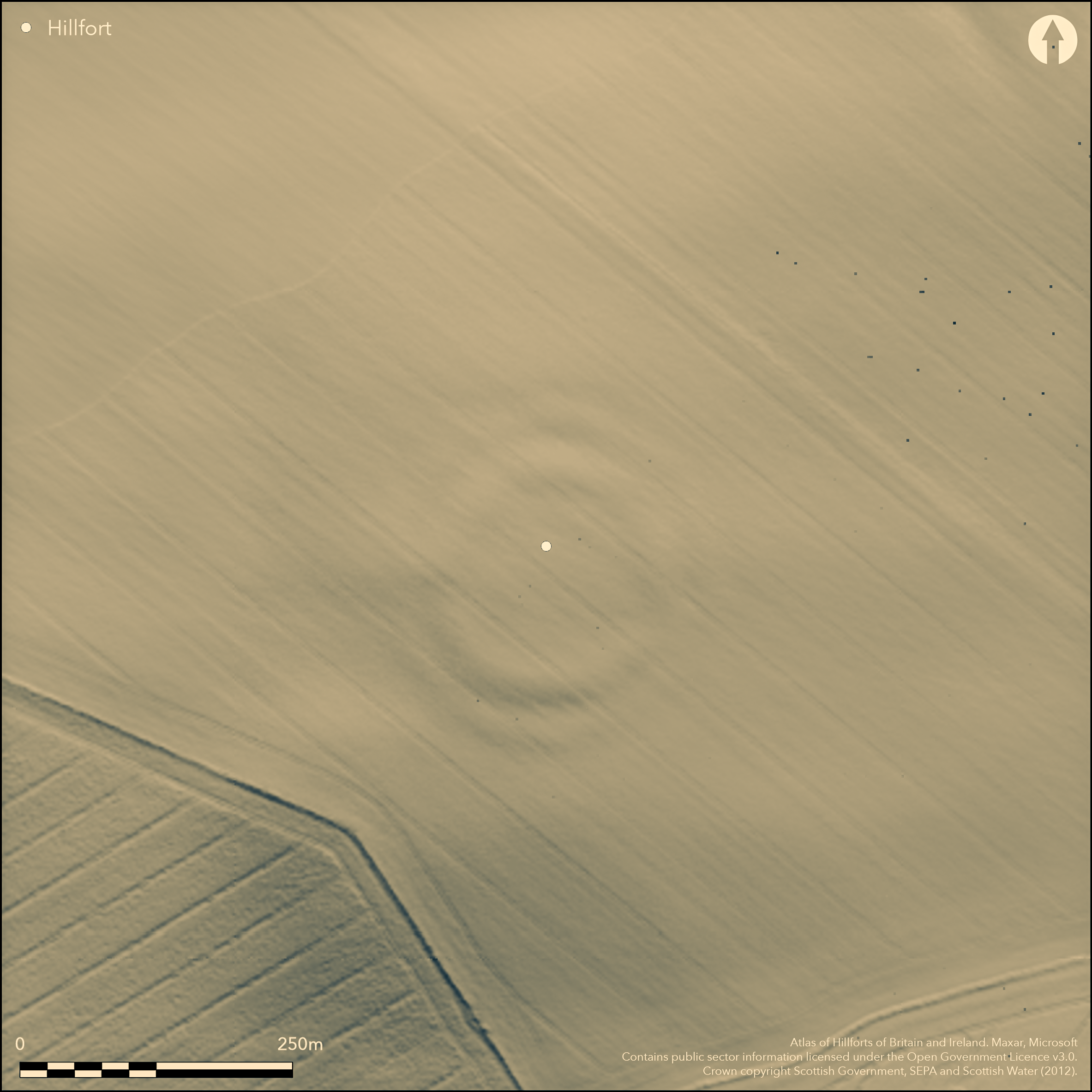
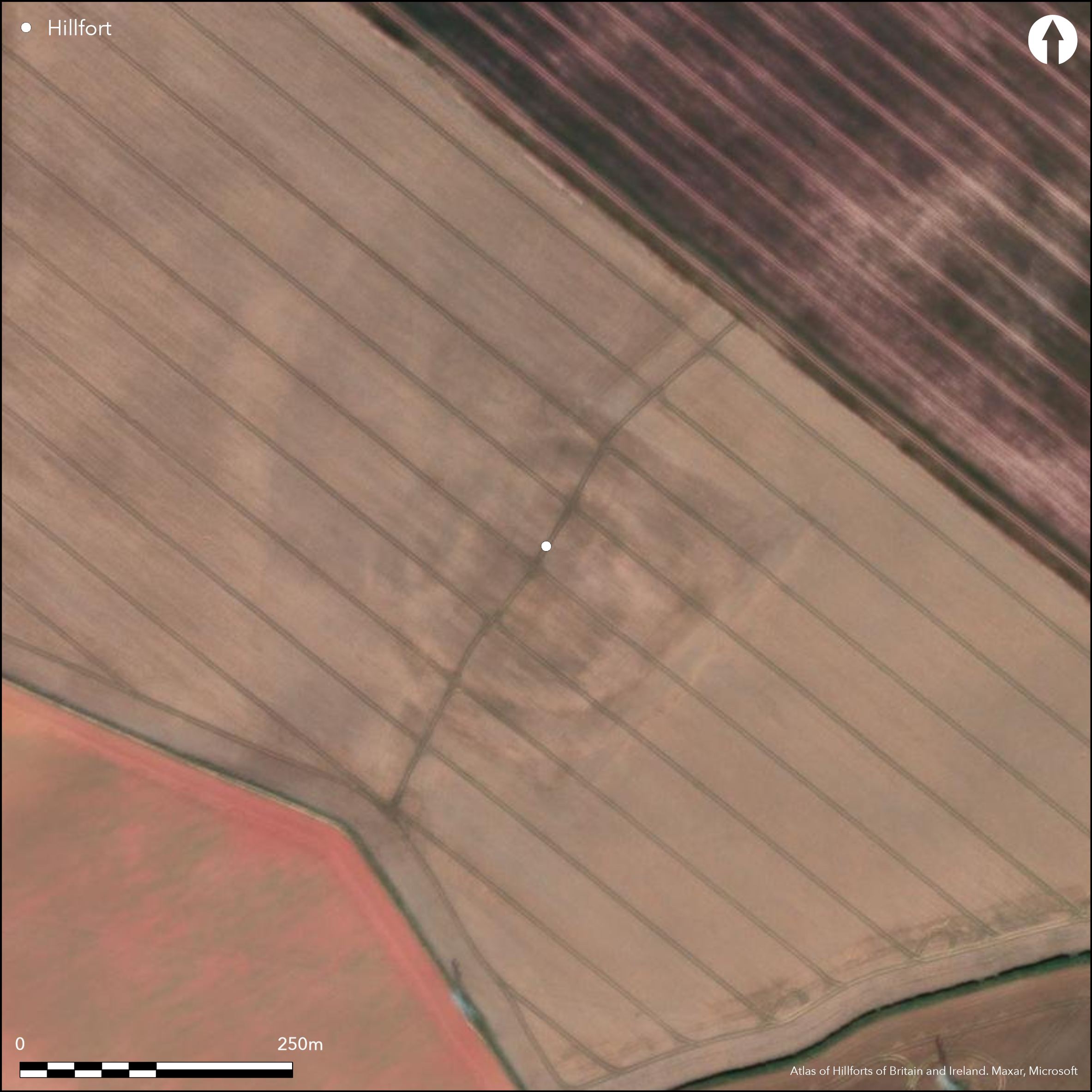
This fort, which is situated on the NW shoulder of the rounded hill above Spott Mill, is heavily ploughed down, but the massive ramparts are still plainly visible, forming broad undulations in the surface of the field, and the ditches have produced strong cropmarks in numerous years of aerial reconnaissance. Roughly circular on plan, it measures 110m from NE to SW by 105m transversely (0.89ha) within two ramparts with external ditches. The gap between the inner ditch and the traces of an internal quarry scoop indicate that the that the inner rampart was in the order of 10m thick, while the inner and outer ditches are 10m and 7m broad respectively. Taken together the defences would have formed an impressive belt in excess of 40m deep, pierced by entrances on the NE, SE, WSW and NNW respectively. Of the latter, that on the NE is a simple gap, as may have been the SE entrance too, except that a tongue of ditch projecting from the S terminal of the outer ditch, which in itself is possibly evidence of a recut phase, closes down the outer gap to create an oblique approach exposing the visitor's right side. The entrance ways of the other two entrances are also angled to expose the visitors right side, but the gaps in the outer ditch have been elaborated in slightly different ways, on the NNW by doglegging the E terminal outwards in front of the inner gap, and on the WSW by turning the S terminal inwards, inside the line of the N terminal, thus creating an overlap. There are several maculae visible on the aerial photographs within the interior, but none resolves into a clear structure. More importantly, the presence of the internal quarry scoop and the massive broad spread of the inner rampart has almost certainly created relatively deep deposits of sediment, particularly in the S half of the interior, that are likely to preserve stratified evidence of occupation.
Citizen Science: ✗
Reliability of Data: Confirmed
Reliability of Interpretation: Confirmed
X: -283448 Y: 7549910 (EPSG: 3857)
Longitude: -2.546260861239277 Latitude: 55.957250776231305 (EPSG:4326)
Country: Scotland
Current County or Unitary Authority: East Lothian
Historic County: East Lothian
Current Parish/Community/Council/Townland: Spott
None
| Extant | ✓ |
| Cropmark | ✓ |
| Likely Destroyed | ✗ |
None
| Woodland | ✗ |
| Commercial Forestry Plantation | ✗ |
| Parkland | ✗ |
| Pasture (Grazing) | ✗ |
| Arable | ✓ |
| Scrub/Bracken | ✗ |
| Bare Outcrop | ✗ |
| Heather/Moorland | ✗ |
| Heath | ✗ |
| Built-up | ✗ |
| Coastal Grassland | ✗ |
| Other | ✗ |
None
| Contour Fort | ✓ |
| Partial Contour Fort | ✗ |
| Promontory Fort | ✗ |
| Hillslope Fort | ✗ |
| Level Terrain Fort | ✗ |
| Marsh Fort | ✗ |
| Multiple Enclosure Fort | ✗ |
| Hilltop | ✓ |
| Coastal Promontory | ✗ |
| Inland Promontory | ✗ |
| Valley Bottom | ✗ |
| Knoll/Hillock/Outcrop | ✗ |
| Ridge | ✗ |
| Cliff/Plateau-edge/Scarp | ✗ |
| Hillslope | ✗ |
| Lowland | ✗ |
| Spur | ✗ |
Dominant Topographic Feature: None
| North | ✗ |
| Northeast | ✗ |
| East | ✗ |
| Southeast | ✗ |
| South | ✗ |
| Southwest | ✗ |
| West | ✗ |
| Northwest | ✗ |
| Level | ✓ |
Altitude: 190.0m
N/A
In the absence of excavation, there are neither stratified artefacts nor radiocarbon dates to provide a chronology for the defences.
Reliability: D - None
| Pre 1200BC | ✗ |
| 1200BC - 800BC | ✗ |
| 800BC - 400BC | ✗ |
| 400BC - AD50 | ✗ |
| AD50 - AD400 | ✗ |
| AD400 - AD 800 | ✗ |
| Post AD800 | ✗ |
| Unknown | ✓ |
| Pre Hillfort: | None |
| Post Hillfort: | Ploughed down |
Photographed by CUCAP in 1948, 1955, 1968, 1969, 1971, 1975 and 1980, by Dennis Harding in 1979, and RCAHMS Aerial Survey Programme in 1977, 1978, 1980, 1982, 1988, 1998, 1999, 2000, 2008, 2013 and 2015
| 1st Identified Map Depiction (1773): | Concentric ring on a hill symbol on Andrew and Mostyn Armstrong's Map of the three Lothians (1773) |
| Other (1853): | Annotated 'British Fort' on the 1st edition OS 6-inch map (Haddingtonshire 1855, sheet 11) |
| Other (1893): | Depicted on the OS 25-inch map (Haddingtonshire 1894, sheet 11.8) |
| Other (1913): | Description (RCAHMS 1924, 108-9, no.167) |
| Other (1954): | Description during RCAHMS Survey of Marginal Lands (Feachem 1963, 124) |
| Other (1966): | Resurveyed at 1:2500 by the OS |
| Other (1993): | Scheduled |
Clear evidence of areas of deeper sediment in the S half of the interior, and elsewhere of several irregular maculae
None
| None | ✓ |
| Spring | ✗ |
| Stream | ✗ |
| Pool | ✗ |
| Flush | ✗ |
| Well | ✗ |
| Other | ✗ |
None
| No Known Features | ✓ |
| Round Stone Structures | ✗ |
| Rectangular Stone Structures | ✗ |
| Curvilinear Platforms | ✗ |
| Other Roundhouse Evidence | ✗ |
| Pits | ✗ |
| Quarry Hollows | ✗ |
| Other | ✗ |
None
| No Known Excavation | ✓ |
| Pits | ✗ |
| Postholes | ✗ |
| Roundhouses | ✗ |
| Rectangular Structures | ✗ |
| Roads/Tracks | ✗ |
| Quarry Hollows | ✗ |
| Other | ✗ |
| Nothing Found | ✗ |
None
| No Known Geophysics | ✓ |
| Pits | ✗ |
| Roundhouses | ✗ |
| Rectangular Structures | ✗ |
| Roads/Tracks | ✗ |
| Quarry Hollows | ✗ |
| Other | ✗ |
| Nothing Found | ✗ |
None
| No Known Finds | ✓ |
| Pottery | ✗ |
| Metal | ✗ |
| Metalworking | ✗ |
| Human Bones | ✗ |
| Animal Bones | ✗ |
| Lithics | ✗ |
| Environmental | ✗ |
| Other | ✗ |
Several irregular maculae that probably indicate the positions of structures
| APs Not Checked | ✗ |
| None | ✗ |
| Roundhouses | ✗ |
| Rectangular Structures | ✗ |
| Pits | ✗ |
| Postholes | ✗ |
| Roads/Tracks | ✗ |
| Other | ✓ |
See main summary
| 4: | The whole circuit is ploughed down |
| 2: | None |
Guard Chambers: ✗
Chevaux de Frise: ✗
| 1. Simple Gap (North east): | Two pairs of opposed ditch terminals |
| 2. Simple Gap (South east): | Initially constructed with symmetrically opposed terminals |
| 2. Oblique (South east): | But evidence of modification of the outer ditch to create an oblique entrance way exposing the visitor's right side |
| 3. Oblique (South west): | Staggered gaps, with a slight outurn of the outer ditch on one side to emphasise the oblique approach exposing right side |
| 3. Simple Gap (South west): | In the inner ditch |
| 3. Hornwork (South west): | Deliberate slight out turn of the outer ditch to create a minor hornwork |
| 4. Oblique (North west): | Oblique approach exposing right side. |
| 4. Simple Gap (North west): | Opposed ditch terminals to either side |
Two ramparts and ditches
| Area 1: | 0.89ha. |
| Total: | 0.89ha. |
Total Footprint Area: 2.7ha.
None
| ✗ | None |
| ✓ | None |
| NE Quadrant: | 2 |
| SE Quadrant: | 2 |
| SW Quadrant: | 2 |
| NW Quadrant: | 2 |
| Total: | 2 |
| Partial Univallate | ✗ |
| Univallate | ✗ |
| Partial Bivallate | ✗ |
| Bivallate | ✓ |
| Partial Multivallate | ✗ |
| Multivallate | ✗ |
| Unknown | ✗ |
| Partial Univallate | ✗ |
| Univallate | ✗ |
| Partial Bivallate | ✗ |
| Bivallate | ✗ |
| Partial Multivallate | ✗ |
| Multivallate | ✗ |
None
| None | ✗ |
| Earthen Bank | ✓ |
| Stone Wall | ✗ |
| Rubble | ✗ |
| Wall-walk | ✗ |
| Evidence of Timber | ✗ |
| Vitrification | ✗ |
| Other Burning | ✗ |
| Palisade | ✗ |
| Counter Scarp Bank | ✗ |
| Berm | ✗ |
| Unfinished | ✗ |
| Other | ✗ |
None
| None | ✗ |
| Earthen Bank | ✗ |
| Stone Wall | ✗ |
| Murus Duplex | ✗ |
| Timber-framed | ✗ |
| Timber-laced | ✗ |
| Vitrification | ✗ |
| Other Burning | ✗ |
| Palisade | ✗ |
| Counter Scarp Bank | ✗ |
| Berm | ✗ |
| Unfinished | ✗ |
| No Known Excavation | ✓ |
| Other | ✗ |
| ✗ | None |
| ✓ | None |
Number of Ditches: 2
| ✗ | None |
Feachem, R W (1963) A guide to prehistoric Scotland. Batsford: London
RCAHMS (1924) The Royal Commission on the Ancient and Historical Monuments and Constructions of Scotland. Eighth report with Inventory of Monuments and Constructions in the County of East Lothian. HMSO: Edinburgh
Atlas of Hillforts:
Wikidata:
This work is licensed under CC BY-SA 4.0![]()
![]()
![]() and should be cited as:
and should be cited as:
Lock, Gary and Ralston, Ian. 2024. Atlas of Hillforts of Britain and Ireland. Available at: https://hillforts.arch.ox.ac.uk
Document Version 1.1