LiDAR 1m DTM Hillshade
Satellite Imagery
LiDAR 1m DTM Hillshade
Satellite Imagery
Scroll left/right to view further images.
HER: East Lothian Council MEL1743 (None)
NMR: NT 68 SW 17 & 30 (57854 & 70843)
SM: 13004
NGR: NT 6019 8474
X: 360193 Y: 684747 (OSGB36)
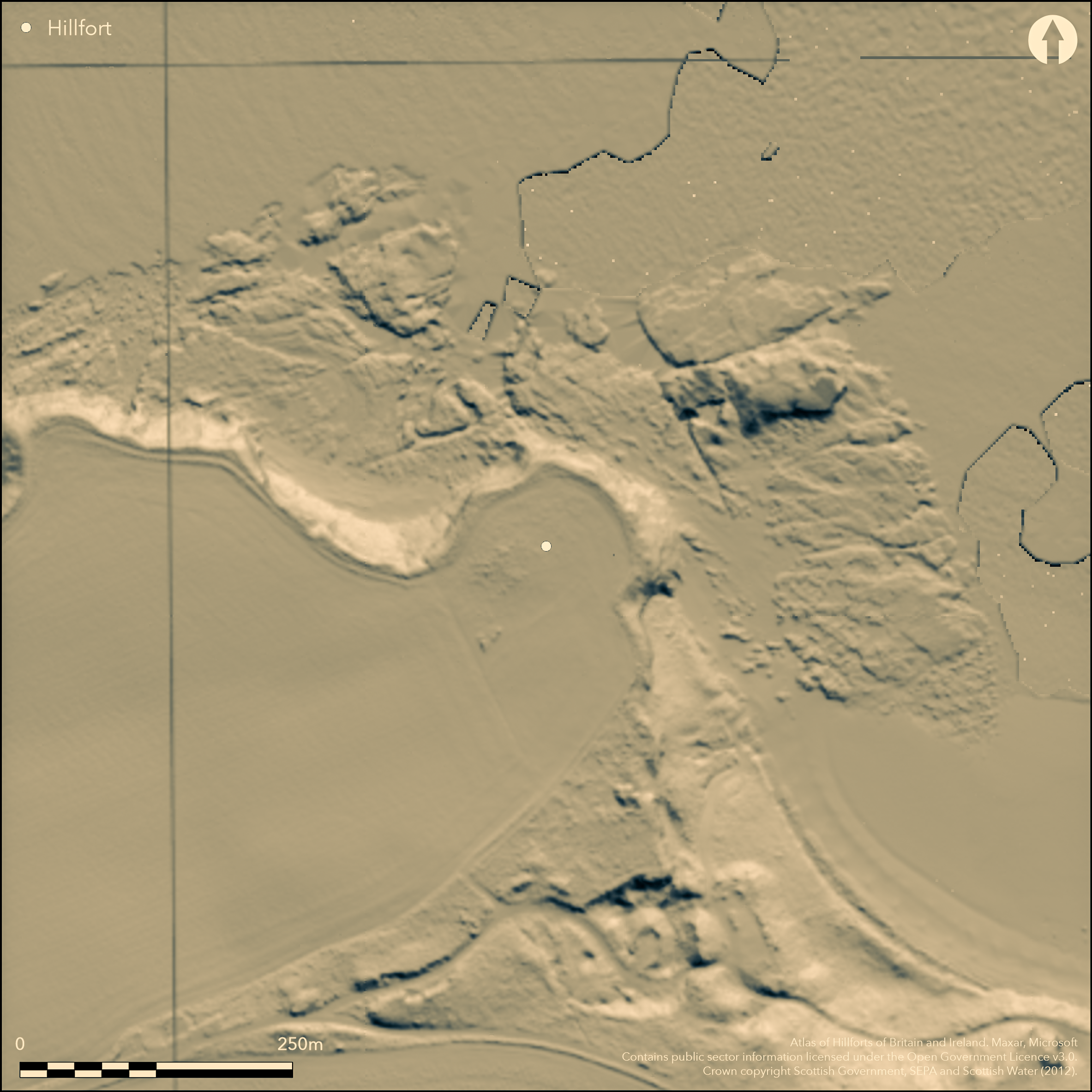
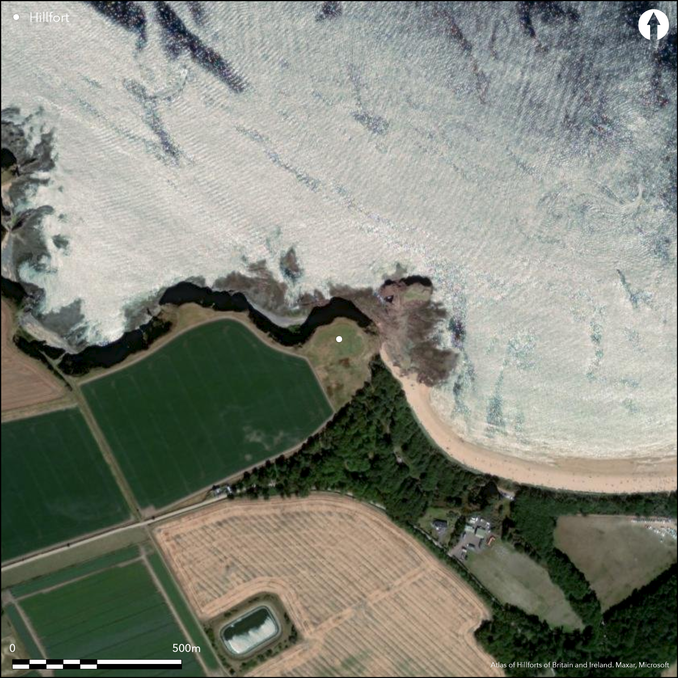
Aerial photography in 1989 identified a ditch cutting off the landward approach to a promontory on the coastal cliffs above Seacliff Harbour, a rocky inlet adjacent to a low stack known as The Gegan, upon which structural remains associated with a midden containing bone needles and pins, a dress-fastener and a decorated comb, together with a Roman gaming piece and a sherd of amphora dating from the 1st or 2nd century AD, were found in the late 19th century (Laidlaw 1870). Girt with cliffs some 20m in height on the NW, NE and SE, the broad ditch barred the approach to the promontory from the SW, enclosing an area measuring about 90m from NW to SE by 60m transversely (0.4ha). Subsequent fieldwork for a coastal survey in 1996 by GUARD on behalf of Historic Scotland observed what was probably the W end of the ditch, about 2m deep, on the cliff-edge, but subsequently ploughing exposed an extensive long cist cemetery which was partly excavated in 2005 and 2008. Carried out by AOC Archaeology Ltd on behalf of Historic Scotland to mitigate damage rather than fully excavate the site, and due to be published shortly, the final report interprets the ditch as part of the vallum of an Anglo-Saxon monastery, in which a timber chapel associated with graves dating from AD 650-780, was replaced about AD 750-850 by a stone founded structure. Evidence of domestic structures dating AD 650-950 were also recovered and the burial-ground remained in use until about 1700. While there is no reason to contest the detail of these conclusions, the incomplete nature of the excavations leaves open the possibility that the monastery had adopted an existing secular cliff-top enclosure, such as seems to have existed at Dunbar (Atlas No.3911).
Citizen Science: ✗
Reliability of Data: Confirmed
Reliability of Interpretation: Confirmed
X: -293964 Y: 7569165 (EPSG: 3857)
Longitude: -2.64072241532175 Latitude: 56.0539604227668 (EPSG:4326)
Country: Scotland
Current County or Unitary Authority: East Lothian
Historic County: East Lothian
Current Parish/Community/Council/Townland: Whitekirk And Tyninghame
None
| Extant | ✗ |
| Cropmark | ✓ |
| Likely Destroyed | ✗ |
None
| Woodland | ✗ |
| Commercial Forestry Plantation | ✗ |
| Parkland | ✗ |
| Pasture (Grazing) | ✓ |
| Arable | ✓ |
| Scrub/Bracken | ✗ |
| Bare Outcrop | ✗ |
| Heather/Moorland | ✗ |
| Heath | ✗ |
| Built-up | ✗ |
| Coastal Grassland | ✗ |
| Other | ✗ |
None
| Contour Fort | ✗ |
| Partial Contour Fort | ✗ |
| Promontory Fort | ✓ |
| Hillslope Fort | ✗ |
| Level Terrain Fort | ✗ |
| Marsh Fort | ✗ |
| Multiple Enclosure Fort | ✗ |
| Hilltop | ✗ |
| Coastal Promontory | ✓ |
| Inland Promontory | ✗ |
| Valley Bottom | ✗ |
| Knoll/Hillock/Outcrop | ✗ |
| Ridge | ✗ |
| Cliff/Plateau-edge/Scarp | ✗ |
| Hillslope | ✗ |
| Lowland | ✗ |
| Spur | ✗ |
Dominant Topographic Feature: None
| North | ✗ |
| Northeast | ✗ |
| East | ✗ |
| Southeast | ✗ |
| South | ✗ |
| Southwest | ✗ |
| West | ✗ |
| Northwest | ✗ |
| Level | ✓ |
Altitude: 22.0m
N/A
The dating of the perimeter is as yet unknown, though it is overlain by elements of the cemetery
Reliability: C - Low
| Pre 1200BC | ✗ |
| 1200BC - 800BC | ✗ |
| 800BC - 400BC | ✗ |
| 400BC - AD50 | ✗ |
| AD50 - AD400 | ✗ |
| AD400 - AD 800 | ✓ |
| Post AD800 | ✗ |
| Unknown | ✗ |
| Pre Hillfort: | None |
| Post Hillfort: | None |
| C14: | No details published |
None
| 1st Identified Written Reference (1989): | First photographed by the RCAHMS Aerial Survey Programme |
| Other (1996): | W end of the ditch observed in the cliff-edge in the course of a coastal survey conducted by GUARD (RCAHMS MS725/138) |
| Excavation (2005): | Rescue excavation of exposed long cists (Hindmarch 2005) |
| Excavation (2008): | Further rescue excavation (Hindmarch 2008) |
| Other (2011): | Scheduled |
Contains successive chapels and also domestic structures belonging to the early medieval monastery
None
| None | ✓ |
| Spring | ✗ |
| Stream | ✗ |
| Pool | ✗ |
| Flush | ✗ |
| Well | ✗ |
| Other | ✗ |
None
| No Known Features | ✓ |
| Round Stone Structures | ✗ |
| Rectangular Stone Structures | ✗ |
| Curvilinear Platforms | ✗ |
| Other Roundhouse Evidence | ✗ |
| Pits | ✗ |
| Quarry Hollows | ✗ |
| Other | ✗ |
Chapel and domestic structures
| No Known Excavation | ✗ |
| Pits | ✗ |
| Postholes | ✗ |
| Roundhouses | ✗ |
| Rectangular Structures | ✓ |
| Roads/Tracks | ✗ |
| Quarry Hollows | ✗ |
| Other | ✓ |
| Nothing Found | ✗ |
None
| No Known Geophysics | ✓ |
| Pits | ✗ |
| Roundhouses | ✗ |
| Rectangular Structures | ✗ |
| Roads/Tracks | ✗ |
| Quarry Hollows | ✗ |
| Other | ✗ |
| Nothing Found | ✗ |
None
| No Known Finds | ✓ |
| Pottery | ✗ |
| Metal | ✗ |
| Metalworking | ✗ |
| Human Bones | ✗ |
| Animal Bones | ✗ |
| Lithics | ✗ |
| Environmental | ✗ |
| Other | ✗ |
NO APPARENT FEATURES
| APs Not Checked | ✗ |
| None | ✓ |
| Roundhouses | ✗ |
| Rectangular Structures | ✗ |
| Pits | ✗ |
| Postholes | ✗ |
| Roads/Tracks | ✗ |
| Other | ✗ |
Not known
| 0: | None |
| 2: | Not known |
Guard Chambers: ✗
Chevaux de Frise: ✗
Single ditch, presumably with upcast rampart
| Area 1: | 0.4ha. |
| Total: | 0.4ha. |
Total Footprint Area: Noneha.
None
| ✗ | None |
| ✗ | None |
| NE Quadrant: | 0 |
| SE Quadrant: | 0 |
| SW Quadrant: | 1 |
| NW Quadrant: | 0 |
| Total: | 1 |
| Partial Univallate | ✓ |
| Univallate | ✗ |
| Partial Bivallate | ✗ |
| Bivallate | ✗ |
| Partial Multivallate | ✗ |
| Multivallate | ✗ |
| Unknown | ✗ |
| Partial Univallate | ✗ |
| Univallate | ✗ |
| Partial Bivallate | ✗ |
| Bivallate | ✗ |
| Partial Multivallate | ✗ |
| Multivallate | ✗ |
None
| None | ✓ |
| Earthen Bank | ✗ |
| Stone Wall | ✗ |
| Rubble | ✗ |
| Wall-walk | ✗ |
| Evidence of Timber | ✗ |
| Vitrification | ✗ |
| Other Burning | ✗ |
| Palisade | ✗ |
| Counter Scarp Bank | ✗ |
| Berm | ✗ |
| Unfinished | ✗ |
| Other | ✗ |
None
| None | ✗ |
| Earthen Bank | ✗ |
| Stone Wall | ✗ |
| Murus Duplex | ✗ |
| Timber-framed | ✗ |
| Timber-laced | ✗ |
| Vitrification | ✗ |
| Other Burning | ✗ |
| Palisade | ✗ |
| Counter Scarp Bank | ✗ |
| Berm | ✗ |
| Unfinished | ✗ |
| No Known Excavation | ✓ |
| Other | ✗ |
| ✗ | None |
| ✓ | None |
Number of Ditches: 1
| ✗ | None |
Hindmarch, E (2005) 'Auldhame (Whitekirk and Tyninghame parish), Early christian cemetery'. Disc Exc Scot, New Ser, 6 (2005), 57-8
Hindmarch, E (2008) 'Auldhame 2008, East Lothian (Whitekirk and Tyninghame parish), walkover and survey'. Disc Exc Scot, New Ser, 9 (2008), 65
Laidlaw, J W (1870) 'Notice of an ancient structure and remains from a "kitchen-midden", on an isolated rock near Seacliff, East Lothian'. Proc Soc Antiq Scot 8 (1868-70), 372-7
Atlas of Hillforts:
Wikidata:
This work is licensed under CC BY-SA 4.0![]()
![]()
![]() and should be cited as:
and should be cited as:
Lock, Gary and Ralston, Ian. 2024. Atlas of Hillforts of Britain and Ireland. Available at: https://hillforts.arch.ox.ac.uk
Document Version 1.1