Satellite Imagery
Satellite Imagery
HER: East Lothian Council MEL1904 (None)
NMR: NT 77 SW 7 (58973)
SM: 3933
NGR: NT 7128 7174
X: 371280 Y: 671740 (OSGB36)
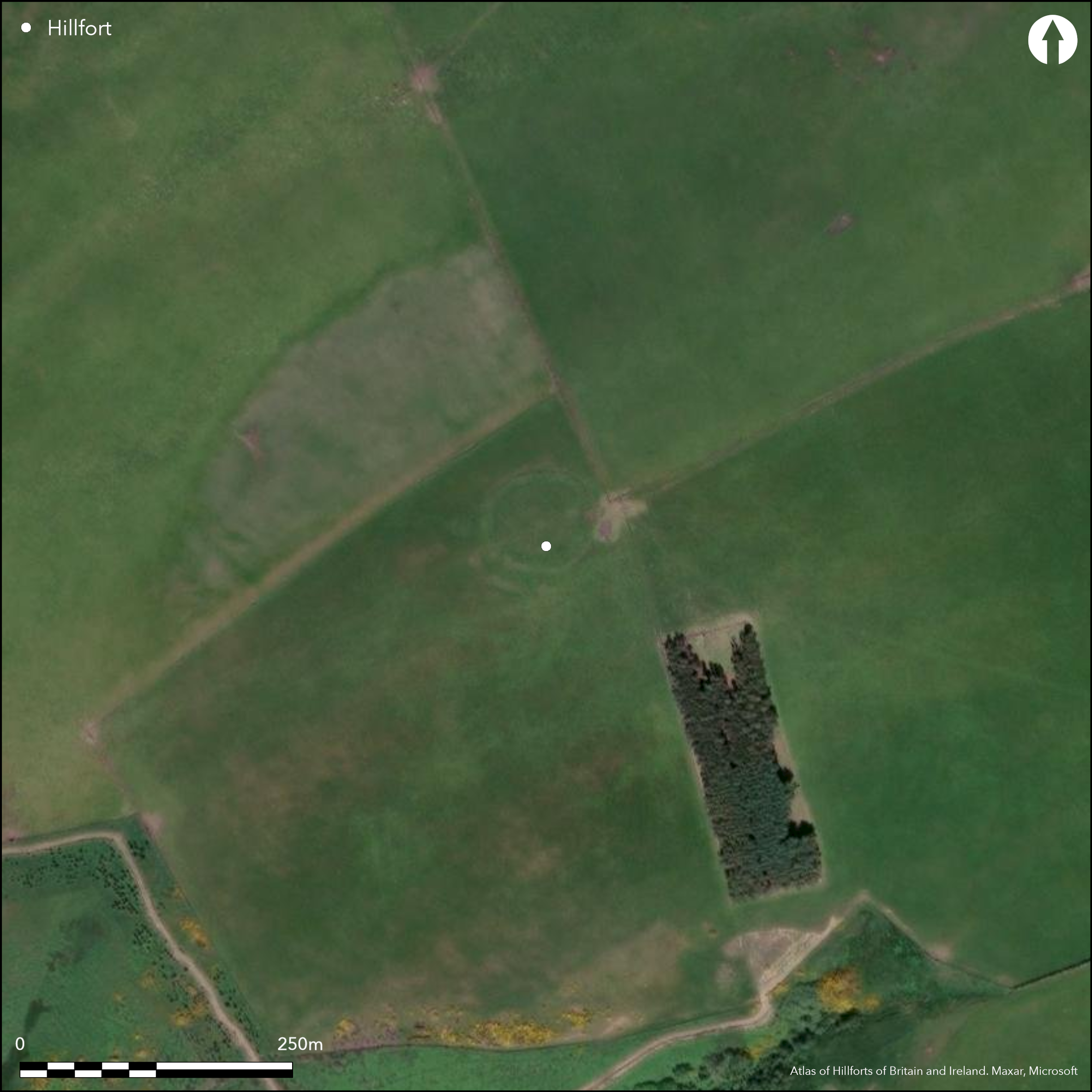
Identified as an ancient fortification on the Armstrongs' Map of the Three Lothians, the enclosure that stands on the NW tip of the crest of Blackcastle Hill is at best a minor settlement enclosure, but around its SW quarter there are the remains of a discontinuous arc of rampart and ditch which may be part of a larger unfinished work enclosing the SW tip of the crest of this steep-sided hill. Comprising a bank rising no more than 1.2m above the bottom of an external ditch about 2m in breadth by 0.5m in depth, the projection of the arc would have enclosed an area about 75m in diameter (0.42ha), though no trace of any other elements of such an enclosure were noted when a plan was drawn up by RCAHMS investigators in 1913, and the surrounding area has been ploughed and re-seeded on numerous occasions since 1946. The perimeter of the enclosure that now occupies most of the area forms a low bank little over 3m in thickness and apparently has been built of material from an internal quarry; at some 1.8m broad by 0.2m deep, the latter is little more than a turf-stripping scar, and as such perhaps suggests a comparatively recent enclosure for this enclosure. Nevertheless, it measures about 50m in diameter and has an entrance on the WSW, and it is generally accepted as a late Iron Age homestead containing traces of two stone-founded round-houses and an arc of ditch of unknown purpose (Feachem 1963, 121-2).
Citizen Science: ✗
Reliability of Data: Confirmed
Reliability of Interpretation: Confirmed
X: -273993 Y: 7546062 (EPSG: 3857)
Longitude: -2.4613203370541976 Latitude: 55.93789375177831 (EPSG:4326)
Country: Scotland
Current County or Unitary Authority: East Lothian
Historic County: East Lothian
Current Parish/Community/Council/Townland: Innerwick
None
| Extant | ✓ |
| Cropmark | ✗ |
| Likely Destroyed | ✗ |
None
| Woodland | ✗ |
| Commercial Forestry Plantation | ✗ |
| Parkland | ✗ |
| Pasture (Grazing) | ✓ |
| Arable | ✗ |
| Scrub/Bracken | ✗ |
| Bare Outcrop | ✗ |
| Heather/Moorland | ✗ |
| Heath | ✗ |
| Built-up | ✗ |
| Coastal Grassland | ✗ |
| Other | ✗ |
None
| Contour Fort | ✓ |
| Partial Contour Fort | ✗ |
| Promontory Fort | ✗ |
| Hillslope Fort | ✗ |
| Level Terrain Fort | ✗ |
| Marsh Fort | ✗ |
| Multiple Enclosure Fort | ✗ |
| Hilltop | ✓ |
| Coastal Promontory | ✗ |
| Inland Promontory | ✗ |
| Valley Bottom | ✗ |
| Knoll/Hillock/Outcrop | ✗ |
| Ridge | ✗ |
| Cliff/Plateau-edge/Scarp | ✗ |
| Hillslope | ✗ |
| Lowland | ✗ |
| Spur | ✗ |
Dominant Topographic Feature: None
| North | ✗ |
| Northeast | ✗ |
| East | ✗ |
| Southeast | ✗ |
| South | ✗ |
| Southwest | ✗ |
| West | ✗ |
| Northwest | ✗ |
| Level | ✓ |
Altitude: 312.0m
N/A
In the absence of excavation, there are neither stratified artefacts nor radiocarbon dates to provide a chronology for the defences.
Reliability: D - None
| Pre 1200BC | ✗ |
| 1200BC - 800BC | ✗ |
| 800BC - 400BC | ✗ |
| 400BC - AD50 | ✗ |
| AD50 - AD400 | ✗ |
| AD400 - AD 800 | ✗ |
| Post AD800 | ✗ |
| Unknown | ✓ |
| Pre Hillfort: | None |
| Post Hillfort: | None |
Photographed by CUCAP in 1969 and by RCAHMS Aerial Survey Programme in 1992 and 2008
| 1st Identified Map Depiction (1773): | Concentric ring on a hill symbol on Andrew and Mostyn Armstrong's Map of the three Lothians (1773) |
| 1st Identified Written Reference (1791): | Noted (Stat Acct i, 1791, 124) |
| Other (1853): | Annotated Fort on the 1st edition OS 6-inch map (Haddingtonshire 1854, sheet 12) |
| Earthwork Survey (1913): | Plan and description (RCAHMS 1924, 55, no.89, fig 96; RCAHMS ELD 6/1) |
| Other (1954): | Description during RCAHMS Survey of Marginal Lands (Feachem 1963, 121-2) |
| Other (1966): | Resurveyed at 1:2500 by the OS |
| Other (1977): | Scheduled |
Within the arc of the unfinished rampart there is a lesser enclosure that appears to be the remains of a small settlement containing traces of two possible stone-founded round-houses and an arc of shallow ditch
None
| None | ✓ |
| Spring | ✗ |
| Stream | ✗ |
| Pool | ✗ |
| Flush | ✗ |
| Well | ✗ |
| Other | ✗ |
None
| No Known Features | ✗ |
| Round Stone Structures | ✓ |
| Rectangular Stone Structures | ✗ |
| Curvilinear Platforms | ✗ |
| Other Roundhouse Evidence | ✗ |
| Pits | ✗ |
| Quarry Hollows | ✗ |
| Other | ✓ |
None
| No Known Excavation | ✓ |
| Pits | ✗ |
| Postholes | ✗ |
| Roundhouses | ✗ |
| Rectangular Structures | ✗ |
| Roads/Tracks | ✗ |
| Quarry Hollows | ✗ |
| Other | ✗ |
| Nothing Found | ✗ |
None
| No Known Geophysics | ✓ |
| Pits | ✗ |
| Roundhouses | ✗ |
| Rectangular Structures | ✗ |
| Roads/Tracks | ✗ |
| Quarry Hollows | ✗ |
| Other | ✗ |
| Nothing Found | ✗ |
None
| No Known Finds | ✓ |
| Pottery | ✗ |
| Metal | ✗ |
| Metalworking | ✗ |
| Human Bones | ✗ |
| Animal Bones | ✗ |
| Lithics | ✗ |
| Environmental | ✗ |
| Other | ✗ |
NO APPARENT FEATURES
| APs Not Checked | ✓ |
| None | ✗ |
| Roundhouses | ✗ |
| Rectangular Structures | ✗ |
| Pits | ✗ |
| Postholes | ✗ |
| Roads/Tracks | ✗ |
| Other | ✗ |
See main summary
| 0: | None |
| 2: | None |
Guard Chambers: ✗
Chevaux de Frise: ✗
An arc of what is probably an unfinished rampart and ditch. While the projected interior can be estimated at 0.42ha, too little of the perimeter exists to allow this figure to be entered below.
| Area 1: | Noneha. |
| Total: | Noneha. |
Total Footprint Area: Noneha.
None
| ✗ | None |
| ✗ | Excludes the perimeter of the minor settlement enclosure |
| NE Quadrant: | 0 |
| SE Quadrant: | 0 |
| SW Quadrant: | 1 |
| NW Quadrant: | 0 |
| Total: | 1 |
| Partial Univallate | ✓ |
| Univallate | ✗ |
| Partial Bivallate | ✗ |
| Bivallate | ✗ |
| Partial Multivallate | ✗ |
| Multivallate | ✗ |
| Unknown | ✗ |
| Partial Univallate | ✗ |
| Univallate | ✗ |
| Partial Bivallate | ✗ |
| Bivallate | ✗ |
| Partial Multivallate | ✗ |
| Multivallate | ✗ |
None
| None | ✗ |
| Earthen Bank | ✓ |
| Stone Wall | ✗ |
| Rubble | ✗ |
| Wall-walk | ✗ |
| Evidence of Timber | ✗ |
| Vitrification | ✗ |
| Other Burning | ✗ |
| Palisade | ✗ |
| Counter Scarp Bank | ✗ |
| Berm | ✗ |
| Unfinished | ✓ |
| Other | ✗ |
None
| None | ✗ |
| Earthen Bank | ✗ |
| Stone Wall | ✗ |
| Murus Duplex | ✗ |
| Timber-framed | ✗ |
| Timber-laced | ✗ |
| Vitrification | ✗ |
| Other Burning | ✗ |
| Palisade | ✗ |
| Counter Scarp Bank | ✗ |
| Berm | ✗ |
| Unfinished | ✗ |
| No Known Excavation | ✓ |
| Other | ✗ |
| ✗ | None |
| ✓ | None |
Number of Ditches: 1
| ✗ | None |
Stat Acct (date) Statistical Account of Scotland: Drawn up from the Communications of the Ministers of the Different Parishes (Sinclair, J ed), 1791-99
Feachem, R W (1963) A guide to prehistoric Scotland. Batsford: London
RCAHMS (1924) The Royal Commission on the Ancient and Historical Monuments and Constructions of Scotland. Eighth report with Inventory of Monuments and Constructions in the County of East Lothian. HMSO: Edinburgh
Atlas of Hillforts:
Wikidata:
This work is licensed under CC BY-SA 4.0![]()
![]()
![]() and should be cited as:
and should be cited as:
Lock, Gary and Ralston, Ian. 2024. Atlas of Hillforts of Britain and Ireland. Available at: https://hillforts.arch.ox.ac.uk
Document Version 1.1