Satellite Imagery
Satellite Imagery
HER: Scottish Borders 54629 (None)
NMR: NT 45 SE 9 (54629)
SM: None
NGR: NT 4979 5466
X: 349790 Y: 654660 (OSGB36)
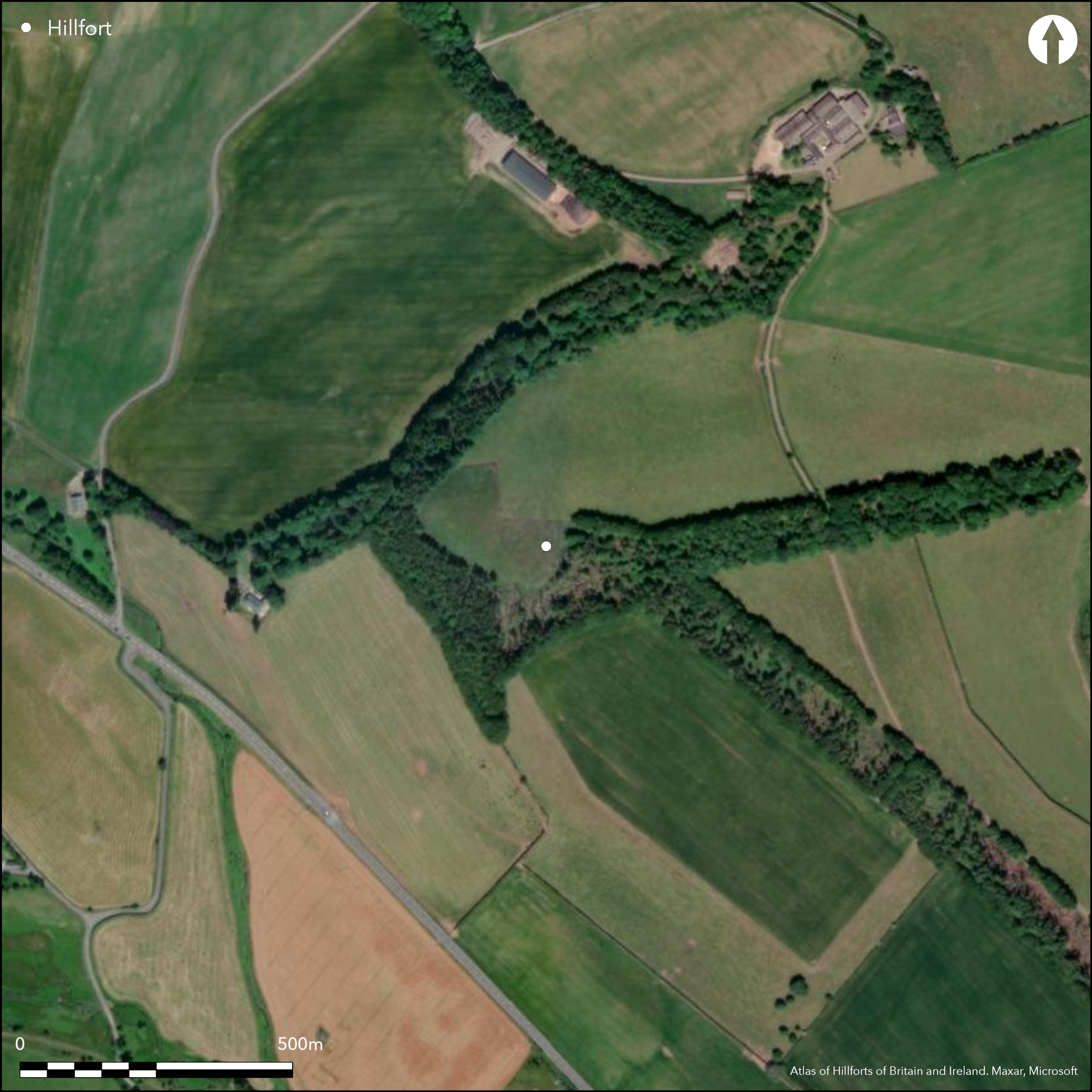
This fort is situated on a hill N of Oxton, overlooking the confluence of Headshaw Haugh and Mountmill Burn from the NE, but rather than occupying the summit, it extends down the W flank. Indeed, its defences are best preserved where they cross the crest of the hill on the ESE, comprising three ramparts with external ditches, though all that is now visible of them are short stretches of the inner and medial rampart, and we are reliant on parchmarks recorded from the air to identify the ditches at this end and what may be the inner ditch at the WNW end. When James Hewat Craw drew up his plan in 1912 (RCAHMS 1915, 16-17, no.32, fig 14) all three ramparts were visible on the ESE and he also identified two scarps on the WNW, but the defences along the flanks had already disappeared. Roughly oval on plan, the interior measures about 100m from ENE to WSW by 64m transversely (0.49ha), and though three or four slightly darker patches appear on the parchmarks, none can be clearly identified as the remains of a round-house. The principal feature visible within the interior is a trapezoidal enclosure which occupies the ESE end and appears to have exploited the inner rampart for one of its sides; the date and purpose of this enclosure are unknown, ranging from a late Iron Age settlement enclosure to a later sheepfold. The main entrance into the fort was probably on the NE, where there are faint traces of a hollow mounting the slope obliquely into the interior, but a shallow indentation in the line of the ditch revealed by the parchmarks on the W possibly marks a second.
Citizen Science: ✗
Reliability of Data: Confirmed
Reliability of Interpretation: Confirmed
X: -311933 Y: 7515274 (EPSG: 3857)
Longitude: -2.8021379407787324 Latitude: 55.782675815886535 (EPSG:4326)
Country: Scotland
Current County or Unitary Authority: Scottish Borders
Historic County: Berwickshire
Current Parish/Community/Council/Townland: Channelkirk
None
| Extant | ✓ |
| Cropmark | ✓ |
| Likely Destroyed | ✗ |
None
| Woodland | ✗ |
| Commercial Forestry Plantation | ✗ |
| Parkland | ✗ |
| Pasture (Grazing) | ✓ |
| Arable | ✓ |
| Scrub/Bracken | ✗ |
| Bare Outcrop | ✗ |
| Heather/Moorland | ✗ |
| Heath | ✗ |
| Built-up | ✗ |
| Coastal Grassland | ✗ |
| Other | ✗ |
None
| Contour Fort | ✗ |
| Partial Contour Fort | ✗ |
| Promontory Fort | ✗ |
| Hillslope Fort | ✓ |
| Level Terrain Fort | ✗ |
| Marsh Fort | ✗ |
| Multiple Enclosure Fort | ✗ |
| Hilltop | ✓ |
| Coastal Promontory | ✗ |
| Inland Promontory | ✗ |
| Valley Bottom | ✗ |
| Knoll/Hillock/Outcrop | ✗ |
| Ridge | ✗ |
| Cliff/Plateau-edge/Scarp | ✗ |
| Hillslope | ✓ |
| Lowland | ✗ |
| Spur | ✗ |
Dominant Topographic Feature: None
| North | ✗ |
| Northeast | ✗ |
| East | ✗ |
| Southeast | ✗ |
| South | ✗ |
| Southwest | ✗ |
| West | ✓ |
| Northwest | ✗ |
| Level | ✗ |
Altitude: 302.0m
N/A
In the absence of excavation, there are neither stratified artefacts nor radiocarbon dates to provide a chronology for the defences.
Reliability: D - None
| Pre 1200BC | ✗ |
| 1200BC - 800BC | ✗ |
| 800BC - 400BC | ✗ |
| 400BC - AD50 | ✗ |
| AD50 - AD400 | ✗ |
| AD400 - AD 800 | ✗ |
| Post AD800 | ✗ |
| Unknown | ✓ |
| Pre Hillfort: | None |
| Post Hillfort: | Overlain by a trapezoidal enclosure, possibly a late Iron Age settlement, and subsequently ploughed down |
Photographed by RCAHMS Aerial Survey Programme in 1981, 1983, 1984, 1991, 1995 and 1996
| 1st Identified Map Depiction (1755): | Shown on William Roy's Military Map of Scotland (1747-55) |
| Other (1826): | T Sharp, Christopher Greenwood, William Fowler's map of The County of Berwick (1826) |
| Other (1853): | Annotated Camp on the OS 25-inch map (Berwick 1854, sheet 13.7) |
| Other (1894): | Description by David Christison (1895, 129) |
| Other (1908): | Description (RCAHMS, 1909, 7, no.32) |
| Earthwork Survey (1912): | Plan by Jame Hewat Craw and description (RCAHMS 1915, 16-17, no.32, fig 14; RCAHMS BWD 12/1) |
| Other (1975): | Visited by the OS |
Contains a trapezoidal enclosure apparently taking advantage of one end of the existing enclosure formed by the inner rampart; this enclosure may be a late Iron Age rectilinear settlement
None
| None | ✓ |
| Spring | ✗ |
| Stream | ✗ |
| Pool | ✗ |
| Flush | ✗ |
| Well | ✗ |
| Other | ✗ |
Improved pasture
| No Known Features | ✓ |
| Round Stone Structures | ✗ |
| Rectangular Stone Structures | ✗ |
| Curvilinear Platforms | ✗ |
| Other Roundhouse Evidence | ✗ |
| Pits | ✗ |
| Quarry Hollows | ✗ |
| Other | ✗ |
None
| No Known Excavation | ✓ |
| Pits | ✗ |
| Postholes | ✗ |
| Roundhouses | ✗ |
| Rectangular Structures | ✗ |
| Roads/Tracks | ✗ |
| Quarry Hollows | ✗ |
| Other | ✗ |
| Nothing Found | ✗ |
None
| No Known Geophysics | ✓ |
| Pits | ✗ |
| Roundhouses | ✗ |
| Rectangular Structures | ✗ |
| Roads/Tracks | ✗ |
| Quarry Hollows | ✗ |
| Other | ✗ |
| Nothing Found | ✗ |
None
| No Known Finds | ✓ |
| Pottery | ✗ |
| Metal | ✗ |
| Metalworking | ✗ |
| Human Bones | ✗ |
| Animal Bones | ✗ |
| Lithics | ✗ |
| Environmental | ✗ |
| Other | ✗ |
Trapezoidal enclosure; several faint darker marks probably indicate the positions of structures
| APs Not Checked | ✗ |
| None | ✗ |
| Roundhouses | ✗ |
| Rectangular Structures | ✗ |
| Pits | ✗ |
| Postholes | ✗ |
| Roads/Tracks | ✗ |
| Other | ✓ |
See main summary
| 2: | Large sectors are ploughed down |
| 2: | No clear detail |
Guard Chambers: ✗
Chevaux de Frise: ✗
| 1. Oblique (North east): | Details not visible but probably an angled approach exposing the visitor's left side |
| 2. Simple Gap (West): | A faint indentation in the line of the parchmark of the inner ditch |
At least three ramparts and external ditches where preserved at one end
| Area 1: | 0.49ha. |
| Total: | 0.49ha. |
Total Footprint Area: 0.14ha.
None
| ✓ | The line of the ditch at the NE corner of the trapezoidal enclosure can be seen crossing the inner rampart |
| ✓ | They certainly did, though there are large gaps along the flanks |
| NE Quadrant: | 3 |
| SE Quadrant: | 3 |
| SW Quadrant: | 1 |
| NW Quadrant: | 2 |
| Total: | 3 |
| Partial Univallate | ✓ |
| Univallate | ✗ |
| Partial Bivallate | ✓ |
| Bivallate | ✗ |
| Partial Multivallate | ✓ |
| Multivallate | ✗ |
| Unknown | ✗ |
| Partial Univallate | ✗ |
| Univallate | ✗ |
| Partial Bivallate | ✗ |
| Bivallate | ✗ |
| Partial Multivallate | ✗ |
| Multivallate | ✗ |
None
| None | ✗ |
| Earthen Bank | ✓ |
| Stone Wall | ✗ |
| Rubble | ✗ |
| Wall-walk | ✗ |
| Evidence of Timber | ✗ |
| Vitrification | ✗ |
| Other Burning | ✗ |
| Palisade | ✗ |
| Counter Scarp Bank | ✗ |
| Berm | ✗ |
| Unfinished | ✗ |
| Other | ✗ |
None
| None | ✗ |
| Earthen Bank | ✗ |
| Stone Wall | ✗ |
| Murus Duplex | ✗ |
| Timber-framed | ✗ |
| Timber-laced | ✗ |
| Vitrification | ✗ |
| Other Burning | ✗ |
| Palisade | ✗ |
| Counter Scarp Bank | ✗ |
| Berm | ✗ |
| Unfinished | ✗ |
| No Known Excavation | ✓ |
| Other | ✗ |
| ✗ | None |
| ✓ | None |
Number of Ditches: 3
| ✗ | None |
Christison, D (1895) 'The forts of Selkirk, the Gala Water, the Southern slopes of the Lammermoors, and the north of Roxburgh'. Proc Soc Antiq Scot 29 (1894-50), 108-79
RCAHMS (1909) The Royal Commission on the Ancient and Historical Monuments and Constructions of Scotland. First report and Inventory of Monuments and Constructions in the County of Berwick. HMSO: Edinburgh.
RCAHMS (1915) The Royal Commission on the Ancient and Historical Monuments and Constructions of Scotland. Sixth report and Inventory of Monuments and Constructions in the County of Berwick (Revised Issue). HMSO: Edinburgh
Atlas of Hillforts:
Wikidata:
This work is licensed under CC BY-SA 4.0![]()
![]()
![]() and should be cited as:
and should be cited as:
Lock, Gary and Ralston, Ian. 2024. Atlas of Hillforts of Britain and Ireland. Available at: https://hillforts.arch.ox.ac.uk
Document Version 1.1