Satellite Imagery
Satellite Imagery
HER: Scottish Borders 54598 (None)
NMR: NT 45 SE 3 (54598)
SM: 4628
NGR: NT 4704 5434
X: 347040 Y: 654340 (OSGB36)
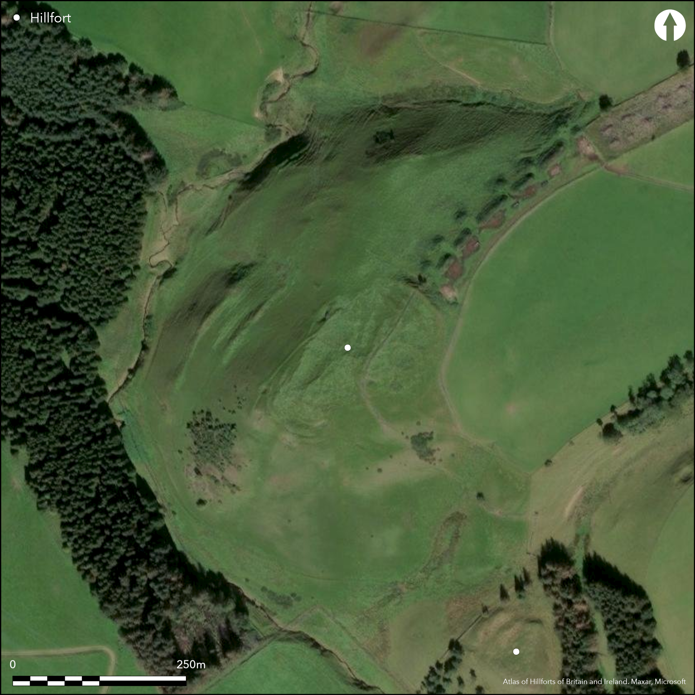
This fort is situated on the sloping crest of the hill to the NW of Kirktonhill, where its SW spur drops down towards the Raughy Burn. The defences have been heavily degraded, partly through later agriculture, which has virtually obliterated them along the flanks, but also by the corner of a shelter belt planted over the E sector, while one later enclosure bank extends obliquely along the NW side, and another, at one time thought to be the perimeter of a Roman temporary camp (see Jones 2011, 171-2), traverses the NE end; several stone quarries have also been dug into the interior and a pentagonal turf-banked agricultural enclosure occupies the SW end. Usually described as oval on plan, this is partly the result of the degradation along its flanks, and aerial photographs and satellite imagery suggest that the line of the twin ramparts with a massive medial ditch visible on the NE swings rather wider down the E flank to create a deep re-entrant in a natural hollow on the S, which almost certainly marks the position of a major entrance, albeit that the details of its design are lost. Three ramparts, largely reduced to terraces, can also be traced round the SW end, set at the point where the underlying slope accelerates into the burn gully. Thus defined, the interior measures about 135m from NE to SW by up to 85m transversely, an area of about 0.82ha. Crossing its NE end, however, there are also traces of two or three low banks, which denote the presence of another defensive scheme taking in a smaller area, perhaps oval and extending to 0.55ha, though neither its full extent nor its precise relationship to the larger fort can be traced out by survey. On the E however, it is almost certainly overlain by a circular enclosure some 18m in internal diameter, which forms a shallow scoop on the E side of the interior and probably represents a late Iron Age settlement overlying the fort.
Citizen Science: ✗
Reliability of Data: Confirmed
Reliability of Interpretation: Confirmed
X: -316806 Y: 7514646 (EPSG: 3857)
Longitude: -2.8459180808536577 Latitude: 55.77950701205967 (EPSG:4326)
Country: Scotland
Current County or Unitary Authority: Scottish Borders
Historic County: Berwickshire
Current Parish/Community/Council/Townland: Channelkirk
None
| Extant | ✓ |
| Cropmark | ✗ |
| Likely Destroyed | ✓ |
None
| Woodland | ✗ |
| Commercial Forestry Plantation | ✗ |
| Parkland | ✗ |
| Pasture (Grazing) | ✓ |
| Arable | ✗ |
| Scrub/Bracken | ✗ |
| Bare Outcrop | ✗ |
| Heather/Moorland | ✓ |
| Heath | ✗ |
| Built-up | ✗ |
| Coastal Grassland | ✗ |
| Other | ✗ |
None
| Contour Fort | ✗ |
| Partial Contour Fort | ✗ |
| Promontory Fort | ✗ |
| Hillslope Fort | ✓ |
| Level Terrain Fort | ✗ |
| Marsh Fort | ✗ |
| Multiple Enclosure Fort | ✗ |
| Hilltop | ✗ |
| Coastal Promontory | ✗ |
| Inland Promontory | ✗ |
| Valley Bottom | ✗ |
| Knoll/Hillock/Outcrop | ✗ |
| Ridge | ✗ |
| Cliff/Plateau-edge/Scarp | ✗ |
| Hillslope | ✓ |
| Lowland | ✗ |
| Spur | ✓ |
Dominant Topographic Feature: None
| North | ✗ |
| Northeast | ✗ |
| East | ✗ |
| Southeast | ✗ |
| South | ✗ |
| Southwest | ✓ |
| West | ✗ |
| Northwest | ✗ |
| Level | ✗ |
Altitude: 327.0m
N/A
In the absence of modern excavation, there are neither stratified artefacts nor radiocarbon dates to provide a chronology for the defences.
Reliability: D - None
| Pre 1200BC | ✗ |
| 1200BC - 800BC | ✗ |
| 800BC - 400BC | ✗ |
| 400BC - AD50 | ✗ |
| AD50 - AD400 | ✗ |
| AD400 - AD 800 | ✗ |
| Post AD800 | ✗ |
| Unknown | ✓ |
| Pre Hillfort: | None |
| Post Hillfort: | Probably overlain by a late Iron Age settlement enclosure and heaviiy degraded by agriculture, tree-planting and quarrying |
Photographed by CUCAP in 1974, 1977 and 1981, and RCAHMS Aerial Survey Programme in 1981, 1995, 1996 and 1998
| Earthwork Survey (1769): | Depicted as a redoubt forming part of the Channelkirk Roman Temporary Camp (Roy 1793, pl vi) |
| Other (1853): | Annotated Camp on the 1st edition OS 25-inch map (Berwick 1854, sheet 13.6) |
| Other (1894): | Description by David Christison, but apparently relying on James Wilson and the OS map (Christison 1895, 128-) |
| Excavation (1897): | Archibald Allan and James Wilson cut a section (Allan 1900, 645, 647-50) |
| Other (1908): | Description (RCAHMS 1909, 6, no.26) |
| Earthwork Survey (1912): | Plan by James Hewat Craw (RCAHMS 1915, 12, no.27, fig 9; RCAHMS BWD 18/1/2) |
| Excavation (1922): | By James Hewat Craw on linear boundary within the fort (324-5, 1930) |
| Other (1975): | Visited by the OS |
| Other (1989): | Scheduled |
Cultivation across the interior has obscured any traces of house platforms, but a shallow circular scoop on the E is almost certainly an overlying late Iron Age settlement enclosure
None
| None | ✓ |
| Spring | ✗ |
| Stream | ✗ |
| Pool | ✗ |
| Flush | ✗ |
| Well | ✗ |
| Other | ✗ |
Circular enclosure scooped into the slope on the E
| No Known Features | ✗ |
| Round Stone Structures | ✗ |
| Rectangular Stone Structures | ✗ |
| Curvilinear Platforms | ✗ |
| Other Roundhouse Evidence | ✗ |
| Pits | ✗ |
| Quarry Hollows | ✗ |
| Other | ✓ |
None
| No Known Excavation | ✓ |
| Pits | ✗ |
| Postholes | ✗ |
| Roundhouses | ✗ |
| Rectangular Structures | ✗ |
| Roads/Tracks | ✗ |
| Quarry Hollows | ✗ |
| Other | ✗ |
| Nothing Found | ✗ |
None
| No Known Geophysics | ✓ |
| Pits | ✗ |
| Roundhouses | ✗ |
| Rectangular Structures | ✗ |
| Roads/Tracks | ✗ |
| Quarry Hollows | ✗ |
| Other | ✗ |
| Nothing Found | ✗ |
None
| No Known Finds | ✓ |
| Pottery | ✗ |
| Metal | ✗ |
| Metalworking | ✗ |
| Human Bones | ✗ |
| Animal Bones | ✗ |
| Lithics | ✗ |
| Environmental | ✗ |
| Other | ✗ |
NO APPARENT FEATURES
| APs Not Checked | ✓ |
| None | ✗ |
| Roundhouses | ✗ |
| Rectangular Structures | ✗ |
| Pits | ✗ |
| Postholes | ✗ |
| Roads/Tracks | ✗ |
| Other | ✗ |
See main summary
| 1: | Large sectors have been levelled on both flanks |
| 2: | None |
Guard Chambers: ✗
Chevaux de Frise: ✗
| 1. Other Forms (South): | forms a deep re-entrant, but all detail has been lost to ploughing |
Almost certainly two separate defensive schemes, a larger circuit with twin ramparts and a medial ditch, and a smaller circuit with up to three ramparts, probably with intermediate ditches.
| Area 1: | 0.82ha. |
| Area 2: | 0.55ha. |
| Total: | 0.82ha. |
Total Footprint Area: Noneha.
None
| ✓ | The intersections of the two schemes have been ploughed down, but must formerly have been visible. The extent of the inner scheme can only be roughly estimated at 0.55ha. |
| ✗ | The principal visible circuit of the larger fort is elaborated below, but there are traces of other ramparts and ditches in the NE end of the interior. |
| NE Quadrant: | 2 |
| SE Quadrant: | 1 |
| SW Quadrant: | 3 |
| NW Quadrant: | 0 |
| Total: | 3 |
| Partial Univallate | ✓ |
| Univallate | ✗ |
| Partial Bivallate | ✓ |
| Bivallate | ✗ |
| Partial Multivallate | ✓ |
| Multivallate | ✗ |
| Unknown | ✗ |
| Partial Univallate | ✗ |
| Univallate | ✗ |
| Partial Bivallate | ✓ |
| Bivallate | ✗ |
| Partial Multivallate | ✗ |
| Multivallate | ✗ |
None
| None | ✗ |
| Earthen Bank | ✓ |
| Stone Wall | ✗ |
| Rubble | ✗ |
| Wall-walk | ✗ |
| Evidence of Timber | ✗ |
| Vitrification | ✗ |
| Other Burning | ✗ |
| Palisade | ✗ |
| Counter Scarp Bank | ✗ |
| Berm | ✗ |
| Unfinished | ✗ |
| Other | ✗ |
None
| None | ✓ |
| Earthen Bank | ✗ |
| Stone Wall | ✗ |
| Murus Duplex | ✗ |
| Timber-framed | ✗ |
| Timber-laced | ✗ |
| Vitrification | ✗ |
| Other Burning | ✗ |
| Palisade | ✗ |
| Counter Scarp Bank | ✗ |
| Berm | ✗ |
| Unfinished | ✗ |
| No Known Excavation | ✗ |
| Other | ✗ |
| ✗ | None |
| ✓ | At least two ditches are present, and probably more in view of the two circuits identifiable |
Number of Ditches: 2
| ✗ | None |
Allan, A (1900) History of Channelkirk. James Thin: Edinburgh
Craw, J H (1930) 'The Roman Camp at Channelkirk, Berwickshire'. Proc Soc Antiq Scot 64 (1929-30), 321-36
Jones, R H. (2011) Roman Camps in Scotland. Society of Antiquaries of Scotland: Edinburgh
RCAHMS (1909) The Royal Commission on the Ancient and Historical Monuments and Constructions of Scotland. First report and Inventory of Monuments and Constructions in the County of Berwick. HMSO: Edinburgh.
RCAHMS (1915) The Royal Commission on the Ancient and Historical Monuments and Constructions of Scotland. Sixth report and Inventory of Monuments and Constructions in the County of Berwick (Revised Issue). HMSO: Edinburgh
Roy, W (1793) The Military Antiquities of the Romans in Britain. Society of Antiquaries of London: London
Atlas of Hillforts:
Wikidata:
This work is licensed under CC BY-SA 4.0![]()
![]()
![]() and should be cited as:
and should be cited as:
Lock, Gary and Ralston, Ian. 2024. Atlas of Hillforts of Britain and Ireland. Available at: https://hillforts.arch.ox.ac.uk
Document Version 1.1