LiDAR 1m DTM Hillshade
Satellite Imagery
LiDAR 1m DTM Hillshade
Satellite Imagery
Scroll left/right to view further images.
HER: Scottish Borders 55534 (None)
NMR: NT 53 NE 5 (55534)
SM: 4463
NGR: NT 5859 3702
X: 358590 Y: 637020 (OSGB36)
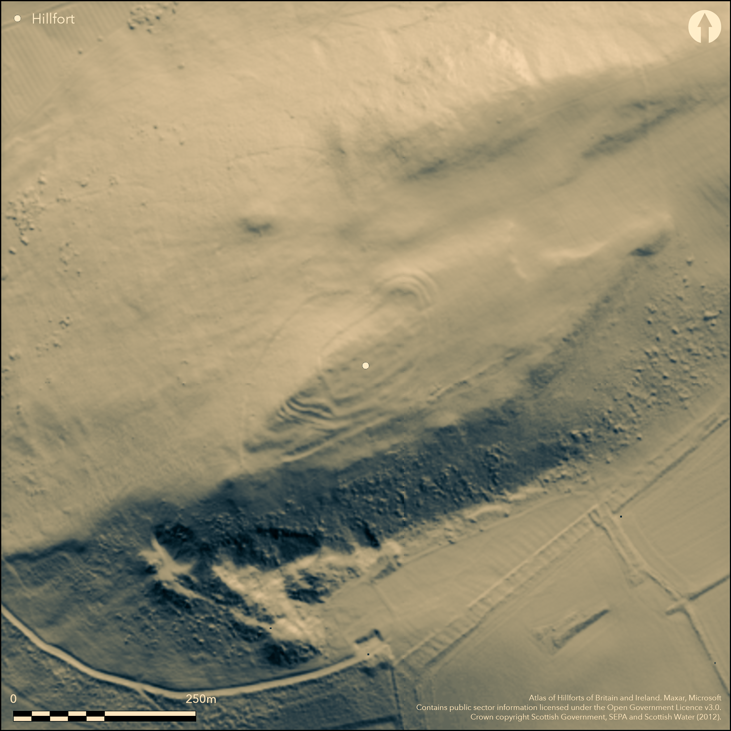
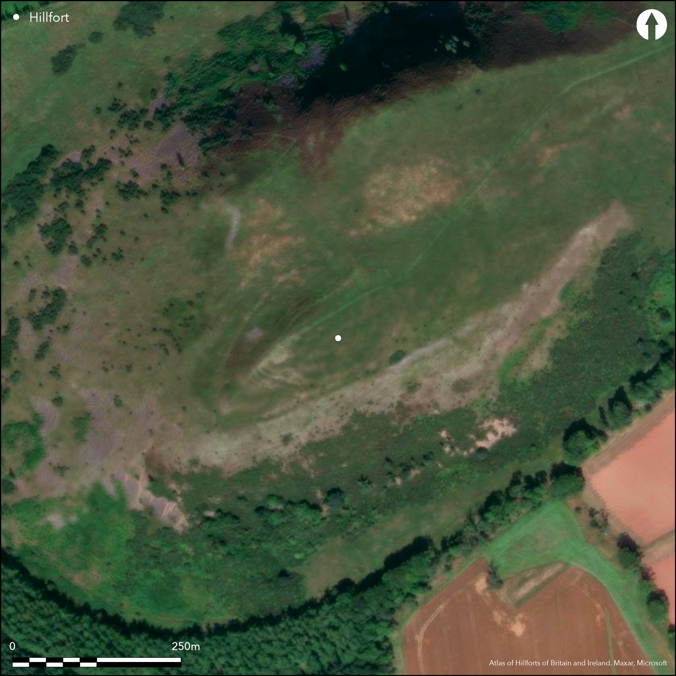
What are evidently the remains of a complex fort are situated on the crest of Black Hill, which is a prominent landmark at the southern end of Lauderdale. Tailored irregularly to the contours of the hill, the last plan of the defences to be drawn up was by James Hewat Craw in 1912 (RCAHMS 1915, 73-4, no.131, fig 71), at a time when the potential complexity of fort defences was neither appreciated nor understood. Reviewed in the light of aerial photography and satellite imagery there appear to be three elements in the defences, namely an inner enclosure with a rectilinear plan, a multivallate enclosure roughly following the contours, and an outer enclosure pursuing an entirely separate line further down the slope. As drawn by Craw, this outermost rampart returns up the slope on the NW to meet the outer rampart of the multivallate belt of defences at right-angles, suggesting that this represents a later phase. This relationship needs to be re-examined, however, for the aerial photographs show little trace of the outer enclosure completing the supposed junction, and in practice the field observation of such relationships where a rampart extends up the slope to meet another on the contour are seldom as clear cut as Craw has depicted. And while the Scheduling document suggests that the earliest phase is a palisaded enclosure on the summit, of which there is no other record and no trace in the available imagery, the outermost enclosure is potentially the remains of an early fort enclosing the upper slopes of this prominent hill. On the SE its rampart peters out on the lip of the steeper slopes along this flank, but in its original form may once have climbed the slope to cross the spine of the hill within the belt of multivallate defences. If so, such a fort would have measured up to 190m in length by 105m in breadth, enclosing an area in the order of 1.5ha. The belt of multivallate defences, which is over 20m deep, is best preserved on the NE and SW, where up to three and five ramparts respectively can be distinguished, though on the N the innermost and second ramparts converge and possibly represent separate phases of construction. The outermost on the NE is certainly accompanied by an external ditch, and other evidence of ditches may have been hidden elsewhere beneath the scarps of the collapsed ramparts. Roughly following the contours, these defences enclose an area measuring about 120m from NE to SW by 45m transversely (0.48ha) and are pierced by an entrance on the NE. Its interior is supposed to have been cultivated in the 19th century, which would certainly account for the degraded state of the innermost rectilinear enclosure. The latter's perimeter is most clearly visible on the SW, where a single rampart reduced to a grass-grown bank cuts across the interior of the multivallate fort, probably adopting the line of the innermost rampart along the flanks and almost obliterated where it returns across the interior on the NE; internally this enclosure measures about 70m from NE to SW by 45m transversely (0.35ha). The complexity of its relationship to the multivallate fort is visible at the S angle, where the innermost rampart of the multivallate system seems to have been reconstructed, doglegging round the corner to overlie the second rampart, which is perhaps evidence of an even later phase of re-fortification. The interior within the rectilinear enclosure is extensively dimpled with shallow scoops that are probably the stances of round-houses; Craw counted no fewer than twelve, but the aerial photographs suggest the presence of similar features throughout the interior.
Citizen Science: ✗
Reliability of Data: Confirmed
Reliability of Interpretation: Confirmed
X: -296017 Y: 7484127 (EPSG: 3857)
Longitude: -2.6591638731955753 Latitude: 55.62502098198837 (EPSG:4326)
Country: Scotland
Current County or Unitary Authority: Scottish Borders
Historic County: Berwickshire
Current Parish/Community/Council/Townland: Earlston
None
| Extant | ✓ |
| Cropmark | ✗ |
| Likely Destroyed | ✗ |
None
| Woodland | ✗ |
| Commercial Forestry Plantation | ✗ |
| Parkland | ✗ |
| Pasture (Grazing) | ✓ |
| Arable | ✗ |
| Scrub/Bracken | ✗ |
| Bare Outcrop | ✗ |
| Heather/Moorland | ✓ |
| Heath | ✗ |
| Built-up | ✗ |
| Coastal Grassland | ✗ |
| Other | ✗ |
None
| Contour Fort | ✓ |
| Partial Contour Fort | ✗ |
| Promontory Fort | ✗ |
| Hillslope Fort | ✗ |
| Level Terrain Fort | ✗ |
| Marsh Fort | ✗ |
| Multiple Enclosure Fort | ✓ |
| Hilltop | ✓ |
| Coastal Promontory | ✗ |
| Inland Promontory | ✗ |
| Valley Bottom | ✗ |
| Knoll/Hillock/Outcrop | ✗ |
| Ridge | ✗ |
| Cliff/Plateau-edge/Scarp | ✗ |
| Hillslope | ✗ |
| Lowland | ✗ |
| Spur | ✗ |
Dominant Topographic Feature: Prominent landmark
| North | ✗ |
| Northeast | ✗ |
| East | ✗ |
| Southeast | ✗ |
| South | ✗ |
| Southwest | ✗ |
| West | ✗ |
| Northwest | ✗ |
| Level | ✓ |
Altitude: 314.0m
N/A
In the absence of excavation, there are neither stratified artefacts nor radiocarbon dates to provide a chronology for the defences.
Reliability: D - None
| Pre 1200BC | ✗ |
| 1200BC - 800BC | ✗ |
| 800BC - 400BC | ✗ |
| 400BC - AD50 | ✗ |
| AD50 - AD400 | ✗ |
| AD400 - AD 800 | ✗ |
| Post AD800 | ✗ |
| Unknown | ✓ |
| Pre Hillfort: | None |
| Post Hillfort: | Interior ploughed in the 19th century |
Photographed by RCAHMS Aerial Survey Programme in 1982, 1983 and 2008
| 1st Identified Written Reference (1831): | Visited by Samuel Hibbert before 1831, probably having been drawn to his attention by Dr Home of Cowdenknowes (1857, 173-4, 182) |
| 1st Identified Map Depiction (1858): | Annotated Camp on the 1st edition OS 25-inch map (Berwick 1862, sheet 30.3) |
| Other (1866): | Description by James Tait (1868), 269 |
| Earthwork Survey (1894): | Partial sketch-plan and description by David Christison (1895, 141-4, fig 16) |
| Other (1908): | Description (RCAHMS, 1909, 25, no.128) |
| Earthwork Survey (1912): | Plan by Jame Hewat Craw and description (RCAHMS 1915, 73-4, no.131, fig 71; RCAHMS BWD 12/1) |
| Other (1923): | Pieces of vitrified stone picked up and subsequently in 1955 donated to the National Museum of Antiquities of Scotland |
| Other (1961): | Revised at 1:2500 by the OS |
| Other (1988): | Scheduled |
Numerous shallow scoops marking the stances of round-houses
None
| None | ✓ |
| Spring | ✗ |
| Stream | ✗ |
| Pool | ✗ |
| Flush | ✗ |
| Well | ✗ |
| Other | ✗ |
None
| No Known Features | ✗ |
| Round Stone Structures | ✗ |
| Rectangular Stone Structures | ✗ |
| Curvilinear Platforms | ✓ |
| Other Roundhouse Evidence | ✗ |
| Pits | ✗ |
| Quarry Hollows | ✗ |
| Other | ✗ |
None
| No Known Excavation | ✓ |
| Pits | ✗ |
| Postholes | ✗ |
| Roundhouses | ✗ |
| Rectangular Structures | ✗ |
| Roads/Tracks | ✗ |
| Quarry Hollows | ✗ |
| Other | ✗ |
| Nothing Found | ✗ |
None
| No Known Geophysics | ✓ |
| Pits | ✗ |
| Roundhouses | ✗ |
| Rectangular Structures | ✗ |
| Roads/Tracks | ✗ |
| Quarry Hollows | ✗ |
| Other | ✗ |
| Nothing Found | ✗ |
None
| No Known Finds | ✓ |
| Pottery | ✗ |
| Metal | ✗ |
| Metalworking | ✗ |
| Human Bones | ✗ |
| Animal Bones | ✗ |
| Lithics | ✗ |
| Environmental | ✗ |
| Other | ✗ |
None
| APs Not Checked | ✗ |
| None | ✗ |
| Roundhouses | ✓ |
| Rectangular Structures | ✗ |
| Pits | ✗ |
| Postholes | ✗ |
| Roads/Tracks | ✗ |
| Other | ✗ |
See main summary
| 1: | None |
| 2: | None |
Guard Chambers: ✗
Chevaux de Frise: ✗
| 1. Simple Gap (North east): | pierces the whole belt of defences |
Multiple ramparts, but probably representing two or three separate schemes of defence, the latest being an inner rectilinear enclosure
| Area 1: | 0.35ha. |
| Area 2: | 0.48ha. |
| Area 3: | 1.5ha. |
| Total: | 1.5ha. |
Total Footprint Area: 1.7ha.
None
| ✓ | While in previous accounts it has been asserted, possibly wrongly, that the outermost rampart butts onto the inner defences on the NW, it is quite clear from aerial photographs, that the innermost rampart represents a relatively late reconstruction, in which a rectilinear plan has been imposed on the earlier circuits |
| ✓ | None |
| NE Quadrant: | 3 |
| SE Quadrant: | 4 |
| SW Quadrant: | 7 |
| NW Quadrant: | 3 |
| Total: | 7 |
| Partial Univallate | ✗ |
| Univallate | ✗ |
| Partial Bivallate | ✗ |
| Bivallate | ✗ |
| Partial Multivallate | ✗ |
| Multivallate | ✓ |
| Unknown | ✗ |
| Partial Univallate | ✗ |
| Univallate | ✗ |
| Partial Bivallate | ✗ |
| Bivallate | ✗ |
| Partial Multivallate | ✗ |
| Multivallate | ✗ |
Numerous bits of vitrifaction have been noted in the past, and four pieces found in 1923 were donated to the NMAS in 1955
| None | ✗ |
| Earthen Bank | ✓ |
| Stone Wall | ✗ |
| Rubble | ✗ |
| Wall-walk | ✗ |
| Evidence of Timber | ✗ |
| Vitrification | ✓ |
| Other Burning | ✗ |
| Palisade | ✗ |
| Counter Scarp Bank | ✗ |
| Berm | ✗ |
| Unfinished | ✗ |
| Other | ✗ |
None
| None | ✗ |
| Earthen Bank | ✗ |
| Stone Wall | ✗ |
| Murus Duplex | ✗ |
| Timber-framed | ✗ |
| Timber-laced | ✗ |
| Vitrification | ✗ |
| Other Burning | ✗ |
| Palisade | ✗ |
| Counter Scarp Bank | ✗ |
| Berm | ✗ |
| Unfinished | ✗ |
| No Known Excavation | ✓ |
| Other | ✗ |
| ✗ | None |
| ✗ | None |
Number of Ditches: None
| ✗ | The outermost rampart might be considered to be an annexe if it could be demonstrated that it butts onto the outer defences on the NW, but this relationship is far from secure, and it is far more likely that this enclosure represents the remains of the earliest fort on the hilltop. |
Christison, D (1895) 'The forts of Selkirk, the Gala Water, the Southern slopes of the Lammermoors, and the north of Roxburgh'. Proc Soc Antiq Scot 29 (1894-50), 108-79
Hibbert, S (1857) 'Observations on the Theories which have been proposed to explain the Vitrified Forts of Scotland'. Archaeologia Scotica 4 (1857), 160-82
Tait, J (1868) 'Earlstoun'. Hist Berwickshire Natur Club 5 (1863-8), 261-9
RCAHMS (1909) The Royal Commission on the Ancient and Historical Monuments and Constructions of Scotland. First report and Inventory of Monuments and Constructions in the County of Berwick. HMSO: Edinburgh.
RCAHMS (1915) The Royal Commission on the Ancient and Historical Monuments and Constructions of Scotland. Sixth report and Inventory of Monuments and Constructions in the County of Berwick (Revised Issue). HMSO: Edinburgh
Atlas of Hillforts:
Wikidata:
This work is licensed under CC BY-SA 4.0![]()
![]()
![]() and should be cited as:
and should be cited as:
Lock, Gary and Ralston, Ian. 2024. Atlas of Hillforts of Britain and Ireland. Available at: https://hillforts.arch.ox.ac.uk
Document Version 1.1