Satellite Imagery
Satellite Imagery
HER: Scottish Borders 56047 (None)
NMR: NT 55 SW 3 (56047)
SM: 372
NGR: NT 5325 5435
X: 353253 Y: 654358 (OSGB36)
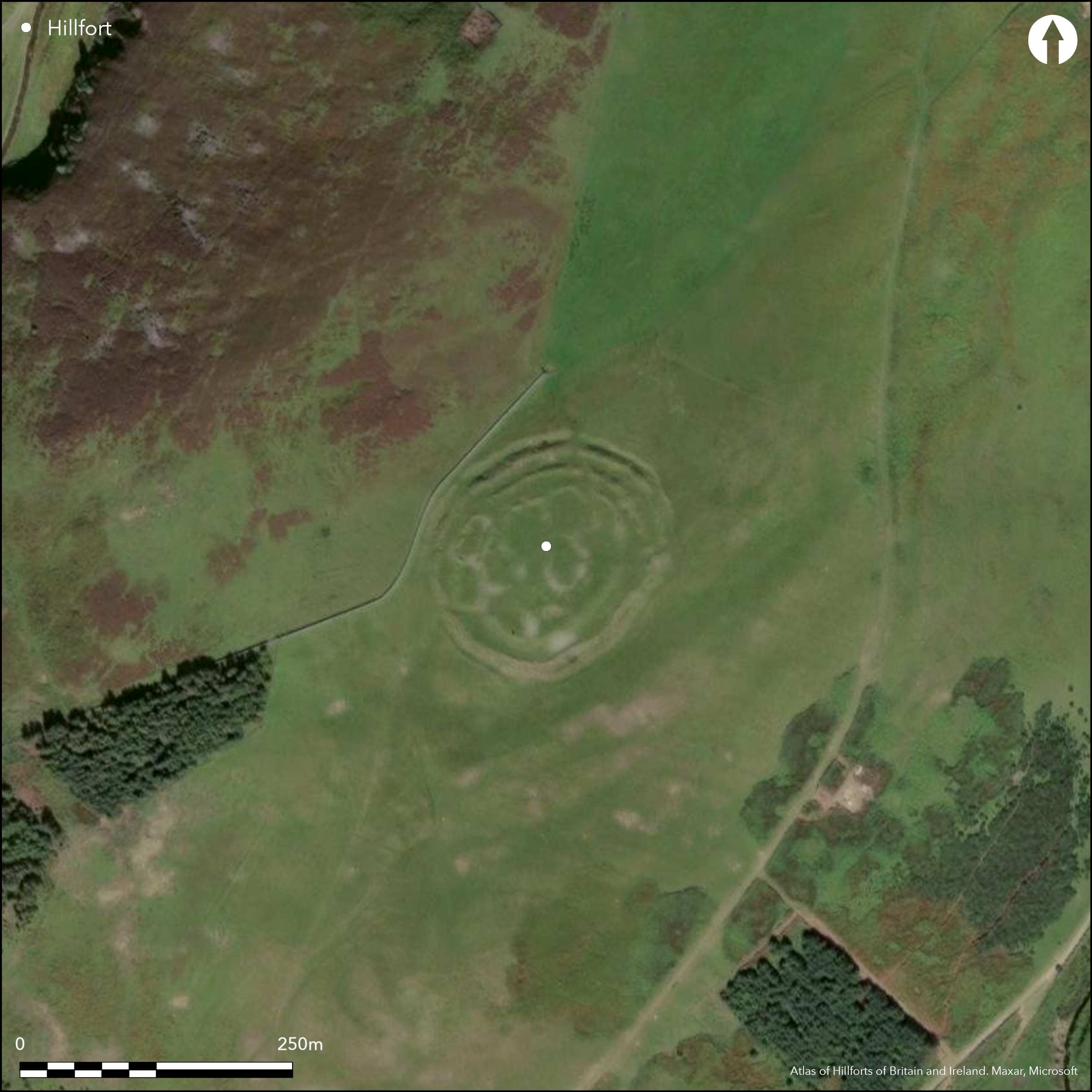
This impressive forts crowns the southern tip of the spur above Longcroft and displays evidence of a complex sequence of construction and occupation. Oval on plan, at first sight the defences comprise no fewer than four ramparts with intermediate ditches, the innermost, which is heavily robbed and obscured by an overlying cluster of courts and yards, enclosing an area measuring 80m from NE to SW by 60m transversely (0.38ha). This enclosure, however, lies eccentrically within the second rampart, which itself overlies the third circuit around the SE and S sectors. Thus, while the first and second ramparts may be contemporary, it appears more likely that they are successive, and that the interior has contracted progressively from an initial defence of a rampart and ditch with intermittent traces of a counterscarp bank, which enclosed an area measuring 115m from NE to SW by 95m transversely (0.86ha); the second rampart, erected with an external ditch immediately within this line on the N and W, reduced the interior to 0.69ha, and the innermost to 0.38ha. There are entrances on the E and the SW, the former probably piercing all four circuits obliquely in such a way as to expose the visitor's right side. The character of the SW entrance is less clear, and access in the later stages would have been impeded by one of the overlying courts, but immediately to its E there is evidence of a shallow hollowed trackway mounting the slope, only to be overlain and blocked by the counterscarp rampart of the earliest identifiable circuit; while this track is thus of some antiquity, possibly indicating a yet earlier enclosure here, it does not necessarily follow that the rest of the deeply worn trackway descending the tip of the spur is quite so ancient, and the majority of the wear that has cut it so deeply into the slope may have been caused by more recent traffic accessing furlongs of medieval or post-medieval rig and outlying hill pastures. The stances of several stone-founded round-houses can be seen amongst the courts and yards sprawled across the interior.
Citizen Science: ✗
Reliability of Data: Confirmed
Reliability of Interpretation: Confirmed
X: -305781 Y: 7514805 (EPSG: 3857)
Longitude: -2.7468753460959743 Latitude: 55.7803103321408 (EPSG:4326)
Country: Scotland
Current County or Unitary Authority: Scottish Borders
Historic County: Berwickshire
Current Parish/Community/Council/Townland: Lauder
None
| Extant | ✓ |
| Cropmark | ✗ |
| Likely Destroyed | ✗ |
None
| Woodland | ✗ |
| Commercial Forestry Plantation | ✗ |
| Parkland | ✗ |
| Pasture (Grazing) | ✓ |
| Arable | ✗ |
| Scrub/Bracken | ✗ |
| Bare Outcrop | ✗ |
| Heather/Moorland | ✓ |
| Heath | ✗ |
| Built-up | ✗ |
| Coastal Grassland | ✗ |
| Other | ✗ |
None
| Contour Fort | ✓ |
| Partial Contour Fort | ✗ |
| Promontory Fort | ✗ |
| Hillslope Fort | ✗ |
| Level Terrain Fort | ✗ |
| Marsh Fort | ✗ |
| Multiple Enclosure Fort | ✗ |
| Hilltop | ✓ |
| Coastal Promontory | ✗ |
| Inland Promontory | ✗ |
| Valley Bottom | ✗ |
| Knoll/Hillock/Outcrop | ✗ |
| Ridge | ✗ |
| Cliff/Plateau-edge/Scarp | ✗ |
| Hillslope | ✗ |
| Lowland | ✗ |
| Spur | ✗ |
Dominant Topographic Feature: None
| North | ✗ |
| Northeast | ✗ |
| East | ✗ |
| Southeast | ✗ |
| South | ✗ |
| Southwest | ✗ |
| West | ✗ |
| Northwest | ✗ |
| Level | ✓ |
Altitude: 350.0m
N/A
In the absence of excavation, there are neither stratified artefacts nor radiocarbon dates to provide a chronology for the defences.
Reliability: D - None
| Pre 1200BC | ✗ |
| 1200BC - 800BC | ✗ |
| 800BC - 400BC | ✗ |
| 400BC - AD50 | ✗ |
| AD50 - AD400 | ✗ |
| AD400 - AD 800 | ✗ |
| Post AD800 | ✗ |
| Unknown | ✓ |
| Pre Hillfort: | None |
| Post Hillfort: | Overlain by a series of yards that probably belong to a late Iron Age settlement |
Photographed under a variety of conditions by CUCAP in 1953 and 1969, by John Dent in 1991 and 1994, and by RCAHMS Aerial Survey Programme in 1976, 1981, 1982, 1983, 1998 and 2010. Visited by S Halliday on several occasions.
| 1st Identified Map Depiction (1755): | On General William Roy's Military Map of Scotland (1747-55) |
| Other (1853): | Annotated Camp on the 1st edition OS 25-inch map (Berwick 1854, sheet 8.8) |
| Other (1883): | Description by James Tait (1884, 312) |
| Earthwork Survey (1894): | Drawn up by Francis Lynn with description (Gunn 1895, 33-5, Christison 1895, 129-31, fig 9) |
| Other (1894): | Also visited by David Christison (1895, 129-31) |
| Other (1897): | Annotated Fort on the 2nd edition OS 25-1nch map (Berwickshire 1898, sheet 13.8) |
| Other (1908): | Description (RCAHMS 1909, 37, no,185) |
| Earthwork Survey (1912): | Drawn up by James Hewat Craw, possibly as early as 1910 (RCAHMS 1915, 108-10, no.211, fig 100; RCAHMS BWD 18/1; BWD 18/1/5) |
| Other (1927): | Scheduled |
| Other (1952): | Description during RCAHMS Survey of Marginal Lands (Feachem 1963, 113) |
| Other (1961): | Re-Scheduled |
| Other (1979): | Surveyed at 1:10,000 by the OS |
Occupied by a series of courts and yards and several stone-founded round-houses, evidently representing an overlying settlement, probably of Late Iron Age date.
None
| None | ✓ |
| Spring | ✗ |
| Stream | ✗ |
| Pool | ✗ |
| Flush | ✗ |
| Well | ✗ |
| Other | ✗ |
Stone-founded round-houses and a series of courts and yards
| No Known Features | ✗ |
| Round Stone Structures | ✓ |
| Rectangular Stone Structures | ✗ |
| Curvilinear Platforms | ✗ |
| Other Roundhouse Evidence | ✗ |
| Pits | ✗ |
| Quarry Hollows | ✗ |
| Other | ✓ |
None
| No Known Excavation | ✓ |
| Pits | ✗ |
| Postholes | ✗ |
| Roundhouses | ✗ |
| Rectangular Structures | ✗ |
| Roads/Tracks | ✗ |
| Quarry Hollows | ✗ |
| Other | ✗ |
| Nothing Found | ✗ |
None
| No Known Geophysics | ✓ |
| Pits | ✗ |
| Roundhouses | ✗ |
| Rectangular Structures | ✗ |
| Roads/Tracks | ✗ |
| Quarry Hollows | ✗ |
| Other | ✗ |
| Nothing Found | ✗ |
None
| No Known Finds | ✓ |
| Pottery | ✗ |
| Metal | ✗ |
| Metalworking | ✗ |
| Human Bones | ✗ |
| Animal Bones | ✗ |
| Lithics | ✗ |
| Environmental | ✗ |
| Other | ✗ |
Stone-founded round-houses and a series of courts and yards
| APs Not Checked | ✗ |
| None | ✗ |
| Roundhouses | ✓ |
| Rectangular Structures | ✗ |
| Pits | ✗ |
| Postholes | ✗ |
| Roads/Tracks | ✗ |
| Other | ✓ |
See main summary
| 3: | None |
| 2: | None |
Guard Chambers: ✗
Chevaux de Frise: ✗
| 1. Oblique (East): | Staggered gaps. Oblique approach exposing right side |
| 2. Simple Gap (South west): | Partly blocked by one of the later enclosures in the interior |
Apparently multivallate, but representing a complex succession of defences that ends in the overlying settlement of courts and yards
| Area 1: | 0.38ha. |
| Area 2: | 0.69ha. |
| Area 3: | 0.86ha. |
| Total: | 0.86ha. |
Total Footprint Area: 1.3ha.
None
| ✓ | The inner of the outer pair of ramparts with their medial ditch is overlain around the SE and S sectors of the circuit, essentially between the two entrances, by a rampart that lies eccentrically to the innermost rampart; both the latter are overlain by courts and yards of the late Iron Age settlement. |
| ✓ | None |
| NE Quadrant: | 3 |
| SE Quadrant: | 2 |
| SW Quadrant: | 2 |
| NW Quadrant: | 3 |
| Total: | 3 |
| Partial Univallate | ✗ |
| Univallate | ✗ |
| Partial Bivallate | ✓ |
| Bivallate | ✗ |
| Partial Multivallate | ✓ |
| Multivallate | ✗ |
| Unknown | ✗ |
| Partial Univallate | ✗ |
| Univallate | ✓ |
| Partial Bivallate | ✗ |
| Bivallate | ✗ |
| Partial Multivallate | ✗ |
| Multivallate | ✗ |
None
| None | ✗ |
| Earthen Bank | ✓ |
| Stone Wall | ✗ |
| Rubble | ✓ |
| Wall-walk | ✗ |
| Evidence of Timber | ✗ |
| Vitrification | ✗ |
| Other Burning | ✗ |
| Palisade | ✗ |
| Counter Scarp Bank | ✓ |
| Berm | ✗ |
| Unfinished | ✗ |
| Other | ✗ |
None
| None | ✗ |
| Earthen Bank | ✗ |
| Stone Wall | ✗ |
| Murus Duplex | ✗ |
| Timber-framed | ✗ |
| Timber-laced | ✗ |
| Vitrification | ✗ |
| Other Burning | ✗ |
| Palisade | ✗ |
| Counter Scarp Bank | ✗ |
| Berm | ✗ |
| Unfinished | ✗ |
| No Known Excavation | ✓ |
| Other | ✗ |
| ✗ | None |
| ✓ | None |
Number of Ditches: 3
| ✗ | None |
Feachem, R W (1963) A guide to prehistoric Scotland. Batsford: London
Gunn, G (1895) 'Report of the Berwickshire Naturalists' Club for the year 1894 (revised by James Hardy)'. Hist Berwickshire Natur Club 15 (1894-5), 30-98
RCAHMS (1909) The Royal Commission on the Ancient and Historical Monuments and Constructions of Scotland. First report and Inventory of Monuments and Constructions in the County of Berwick. HMSO: Edinburgh.
RCAHMS (1915) The Royal Commission on the Ancient and Historical Monuments and Constructions of Scotland. Sixth report and Inventory of Monuments and Constructions in the County of Berwick (Revised Issue). HMSO: Edinburgh
Tait, J (1884) 'On the Black Dyke and some British camps in the west of Berwickshire'. Hist Berwickshire Natur Club 10 (1882-4), 307-12
Atlas of Hillforts:
Wikidata:
This work is licensed under CC BY-SA 4.0![]()
![]()
![]() and should be cited as:
and should be cited as:
Lock, Gary and Ralston, Ian. 2024. Atlas of Hillforts of Britain and Ireland. Available at: https://hillforts.arch.ox.ac.uk
Document Version 1.1