LiDAR 1m DTM Hillshade
Satellite Imagery
LiDAR 1m DTM Hillshade
Satellite Imagery
Scroll left/right to view further images.
HER: Scottish Borders 56057 (None)
NMR: NT 55 SW 5 (56057)
SM: 362
NGR: NT 5232 5363
X: 352320 Y: 653633 (OSGB36)
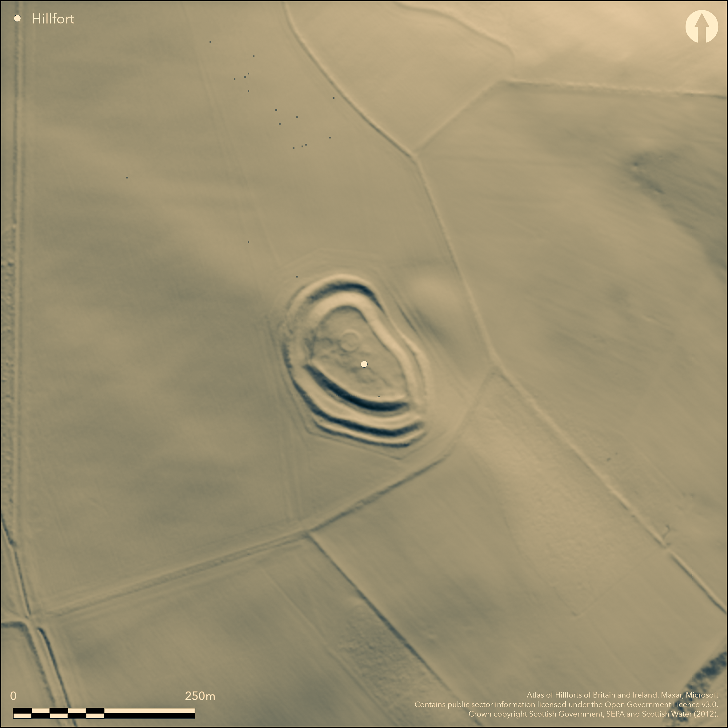
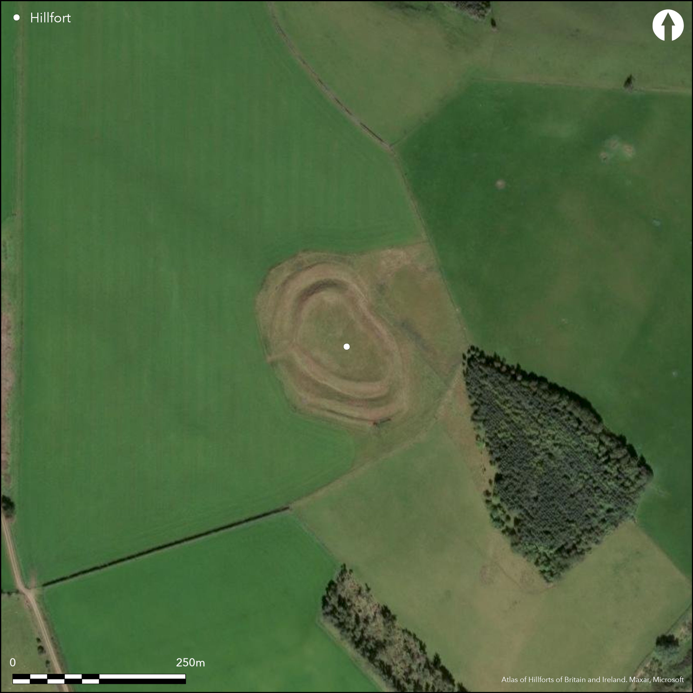
This fort is situated above the farm on the tip of the SE spur of Addinston Hill, dropping down gently from its W end which is set across the crest of the spur. Flattened along its NE flank, where it has been tailored to the underlying topography, it forms an irregular oval on plan and measures about 82m from NW to SE by 50m transversely (0.31ha) within one of the most impressive defences to be found anywhere in the Border counties. Comprising twin ramparts with external ditches, the outer flanked by a counterscarp bank surviving only in the S sector on the downslope side, they not only form a belt some 33m deep, but the inner rampart and ditch have been constructed on a massive scale, particularly where they cut across the crest of the spur on the NW; in this sector the ditch is in excess of 10m in breadth. While the ramparts and ditches have all the appearance of an unitary scheme, an unusual berm formed between the outer lip of the inner ditch and the outer rampart in the southern sector suggests that in its present form either the outer ramparts and ditch are an eccentric addition to the inner circuit, or possibly a more extensive reconstruction of the inner rampart within an earlier fort, reducing the interior at the SE end. A causeway across the inner ditch marks the position of an entrance at the SE end, but it is unclear whether such feature exists at a second gap in the ramparts on the SW. A ring-bank within the NW end of the interior is likely to be the remains of an old sheepfold, but there are traces of the backs of at least three circular platforms cut into the slope on the SW.
Citizen Science: ✗
Reliability of Data: Confirmed
Reliability of Interpretation: Confirmed
X: -307422 Y: 7513498 (EPSG: 3857)
Longitude: -2.761622229038944 Latitude: 55.77370538579293 (EPSG:4326)
Country: Scotland
Current County or Unitary Authority: Scottish Borders
Historic County: Berwickshire
Current Parish/Community/Council/Townland: Lauder
None
| Extant | ✓ |
| Cropmark | ✗ |
| Likely Destroyed | ✗ |
None
| Woodland | ✗ |
| Commercial Forestry Plantation | ✗ |
| Parkland | ✗ |
| Pasture (Grazing) | ✓ |
| Arable | ✗ |
| Scrub/Bracken | ✗ |
| Bare Outcrop | ✗ |
| Heather/Moorland | ✗ |
| Heath | ✗ |
| Built-up | ✗ |
| Coastal Grassland | ✗ |
| Other | ✗ |
On the very tip of a spur and descending down the gently-sloping crest
| Contour Fort | ✓ |
| Partial Contour Fort | ✗ |
| Promontory Fort | ✗ |
| Hillslope Fort | ✗ |
| Level Terrain Fort | ✗ |
| Marsh Fort | ✗ |
| Multiple Enclosure Fort | ✗ |
| Hilltop | ✓ |
| Coastal Promontory | ✗ |
| Inland Promontory | ✗ |
| Valley Bottom | ✗ |
| Knoll/Hillock/Outcrop | ✗ |
| Ridge | ✗ |
| Cliff/Plateau-edge/Scarp | ✗ |
| Hillslope | ✓ |
| Lowland | ✗ |
| Spur | ✓ |
Dominant Topographic Feature: None
| North | ✗ |
| Northeast | ✗ |
| East | ✗ |
| Southeast | ✓ |
| South | ✗ |
| Southwest | ✗ |
| West | ✗ |
| Northwest | ✗ |
| Level | ✗ |
Altitude: 305.0m
N/A
In the absence of excavation, there are neither stratified artefacts nor radiocarbon dates to provide a chronology for the defences.
Reliability: D - None
| Pre 1200BC | ✗ |
| 1200BC - 800BC | ✗ |
| 800BC - 400BC | ✗ |
| 400BC - AD50 | ✗ |
| AD50 - AD400 | ✗ |
| AD400 - AD 800 | ✗ |
| Post AD800 | ✗ |
| Unknown | ✓ |
| Pre Hillfort: | None |
| Post Hillfort: | Overlain by a circular sheep fold within th einterior |
Photographed by CUCAP in 1953, 1969 and 1972, and by RCAHMS Aerial Survey Programme in 1976, 1980, 1983, 1986, 1995, 1999, 2009 and 2010
| 1st Identified Map Depiction (1755): | On General William Roy's Military Map of Scotland (1747-55) |
| Other (1853): | Annotated Camp on the 1st edition OS 25-inch map (Berwick 1854, sheet 13.12) |
| Other (1883): | Description by James Tait (1884, 312) |
| Other (1894): | Description by Francis Lynn reported (Gunn 1895, 31), while David Christison uses a sketch of Lynn's (1895, 133, fig 12) |
| Earthwork Survey (1894): | Sketch-plan and description by David Christison (1895, 131-4, fig 10) |
| Other (1908): | Description (RCAHMS 1909, 38, no.187) |
| Earthwork Survey (1912): | Plan drawn up by James Hewat Craw, possibly as early as 1910 (RCAHMS 1915, 110-12, no.213, fig 102; RCAHMS BWD 20/1; BWD 20/1/2) |
| Other (1927): | Scheduled |
| Other (1961): | Re-Scheduled |
| Other (1963): | Revised at 1:2500 by the OS |
| Other (1975): | Visited by the OS |
A pronounced ring-bank in the NW end of the interior is generally thought to be the remains of an old sheepfold (Feachem 1963, 113), but the backs of at least three house platforms can also be seen cut back into the slope on the SW
None
| None | ✓ |
| Spring | ✗ |
| Stream | ✗ |
| Pool | ✗ |
| Flush | ✗ |
| Well | ✗ |
| Other | ✗ |
None
| No Known Features | ✗ |
| Round Stone Structures | ✗ |
| Rectangular Stone Structures | ✗ |
| Curvilinear Platforms | ✓ |
| Other Roundhouse Evidence | ✗ |
| Pits | ✗ |
| Quarry Hollows | ✗ |
| Other | ✗ |
None
| No Known Excavation | ✓ |
| Pits | ✗ |
| Postholes | ✗ |
| Roundhouses | ✗ |
| Rectangular Structures | ✗ |
| Roads/Tracks | ✗ |
| Quarry Hollows | ✗ |
| Other | ✗ |
| Nothing Found | ✗ |
None
| No Known Geophysics | ✓ |
| Pits | ✗ |
| Roundhouses | ✗ |
| Rectangular Structures | ✗ |
| Roads/Tracks | ✗ |
| Quarry Hollows | ✗ |
| Other | ✗ |
| Nothing Found | ✗ |
None
| No Known Finds | ✓ |
| Pottery | ✗ |
| Metal | ✗ |
| Metalworking | ✗ |
| Human Bones | ✗ |
| Animal Bones | ✗ |
| Lithics | ✗ |
| Environmental | ✗ |
| Other | ✗ |
Traces of platforms in addition to the ring-bank
| APs Not Checked | ✗ |
| None | ✗ |
| Roundhouses | ✓ |
| Rectangular Structures | ✗ |
| Pits | ✗ |
| Postholes | ✗ |
| Roads/Tracks | ✗ |
| Other | ✓ |
See main summary
| 2: | None |
| 2: | None |
Guard Chambers: ✗
Chevaux de Frise: ✗
| 1. Simple Gap (South east): | Causeway across the ditch |
| 2. Simple Gap (South west): | No sign of a causeway spanning the ditch and this gap may be the result of erosion and later access. |
Twin ramparts and ditches around most of the circuit, with an outer counterscarp bank surviving in the S sector
| Area 1: | 0.31ha. |
| Total: | 0.31ha. |
Total Footprint Area: Noneha.
None
| ✓ | The unusual berm between the outer rampart and the inner ditch around the S sector is probably the result of multiperiod construction |
| ✓ | None |
| NE Quadrant: | 2 |
| SE Quadrant: | 2 |
| SW Quadrant: | 2 |
| NW Quadrant: | 2 |
| Total: | 2 |
| Partial Univallate | ✗ |
| Univallate | ✗ |
| Partial Bivallate | ✗ |
| Bivallate | ✓ |
| Partial Multivallate | ✗ |
| Multivallate | ✗ |
| Unknown | ✗ |
| Partial Univallate | ✗ |
| Univallate | ✗ |
| Partial Bivallate | ✗ |
| Bivallate | ✗ |
| Partial Multivallate | ✗ |
| Multivallate | ✗ |
None
| None | ✗ |
| Earthen Bank | ✓ |
| Stone Wall | ✗ |
| Rubble | ✗ |
| Wall-walk | ✗ |
| Evidence of Timber | ✗ |
| Vitrification | ✗ |
| Other Burning | ✗ |
| Palisade | ✗ |
| Counter Scarp Bank | ✓ |
| Berm | ✗ |
| Unfinished | ✗ |
| Other | ✗ |
None
| None | ✗ |
| Earthen Bank | ✗ |
| Stone Wall | ✗ |
| Murus Duplex | ✗ |
| Timber-framed | ✗ |
| Timber-laced | ✗ |
| Vitrification | ✗ |
| Other Burning | ✗ |
| Palisade | ✗ |
| Counter Scarp Bank | ✗ |
| Berm | ✗ |
| Unfinished | ✗ |
| No Known Excavation | ✓ |
| Other | ✗ |
| ✗ | None |
| ✓ | None |
Number of Ditches: 2
| ✗ | None |
Feachem, R W (1963) A guide to prehistoric Scotland. Batsford: London
Gunn, G (1895) 'Report of the Berwickshire Naturalists' Club for the year 1894 (revised by James Hardy)'. Hist Berwickshire Natur Club 15 (1894-5), 30-98
RCAHMS (1909) The Royal Commission on the Ancient and Historical Monuments and Constructions of Scotland. First report and Inventory of Monuments and Constructions in the County of Berwick. HMSO: Edinburgh.
RCAHMS (1915) The Royal Commission on the Ancient and Historical Monuments and Constructions of Scotland. Sixth report and Inventory of Monuments and Constructions in the County of Berwick (Revised Issue). HMSO: Edinburgh
Tait, J (1884) 'On the Black Dyke and some British camps in the west of Berwickshire'. Hist Berwickshire Natur Club 10 (1882-4), 307-12
Atlas of Hillforts:
Wikidata:
This work is licensed under CC BY-SA 4.0![]()
![]()
![]() and should be cited as:
and should be cited as:
Lock, Gary and Ralston, Ian. 2024. Atlas of Hillforts of Britain and Ireland. Available at: https://hillforts.arch.ox.ac.uk
Document Version 1.1