Satellite Imagery
Satellite Imagery
HER: Scottish Borders 55967 (None)
NMR: NT 55 NW 10 (55967)
SM: 4478
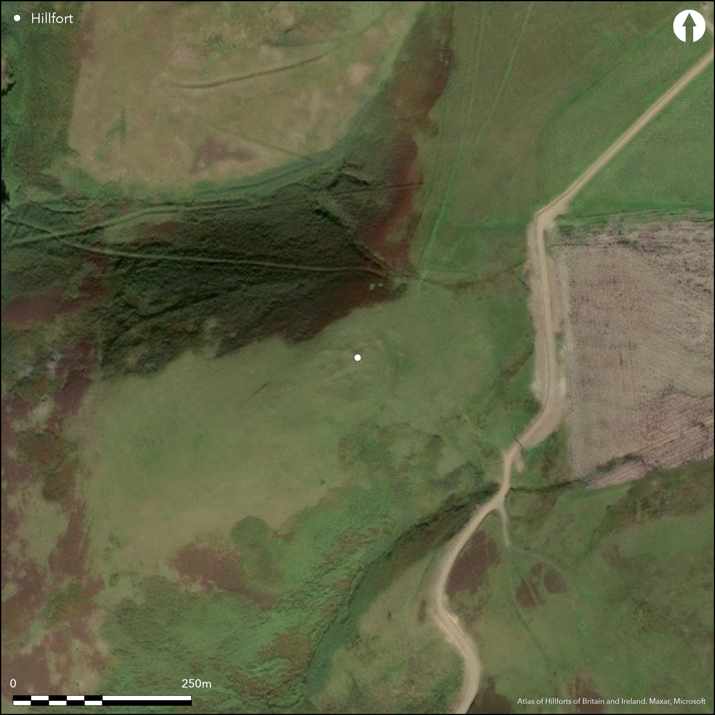
NGR: NT 5211 5639
X: 352110 Y: 656390 (OSGB36)
This fort is situated on a steep-sided spur dropping down on either flank into sikes that drain westwards into the Kelphope Burn. The full extent of the fort is difficult to determine, having been ploughed down and heavily reduced probably during the late 18th century, and having appeared on General William Roy's Military Map of Scotland (1747-55) it escapes further notice until 1908 (RCAHMS 1909, 40-1, no.197). The most prominent element of the defences are two ramparts with a medial ditch defending the more accessible NE flank, but in 1979 an OS surveyor traced the inner rampart round the rest of the rounded summit, though it had been reduced to little more than an intermittent scarp. The measurements given by the OS of 154m in length by 38m in breadth, however, do not resolve with any features visible on aerial photographs and satellite imagery, and the only possible traces of a perimeter enclose an area measuring no more than 135m from NE to SW by 45m transversely (0.58ha). To the rear of the inner rampart on the NE, separated from it by a broad hollow, what may be the remains of a wall can be seen enclosing a smaller area some 60m across on NE end of a rocky spine that extends down the axis of the interior. Up to eight platforms for round-houses are visible in this area, and the OS suggested this enclosure was the remains of a later settlement within the interior of the fort. The entrance into the fort is on the NE where a later field-bank also traverses the defences.
Citizen Science: ✗
Reliability of Data: Unconfirmed
Reliability of Interpretation: Confirmed
X: -307849 Y: 7518398 (EPSG: 3857)
Longitude: -2.7654550061829877 Latitude: 55.798454527857665 (EPSG:4326)
Country: Scotland
Current County or Unitary Authority: Scottish Borders
Historic County: Berwickshire
Current Parish/Community/Council/Townland: Lauder
None
| Extant | ✓ |
| Cropmark | ✗ |
| Likely Destroyed | ✓ |
None
| Woodland | ✗ |
| Commercial Forestry Plantation | ✗ |
| Parkland | ✗ |
| Pasture (Grazing) | ✓ |
| Arable | ✗ |
| Scrub/Bracken | ✗ |
| Bare Outcrop | ✗ |
| Heather/Moorland | ✓ |
| Heath | ✗ |
| Built-up | ✗ |
| Coastal Grassland | ✗ |
| Other | ✗ |
None
| Contour Fort | ✓ |
| Partial Contour Fort | ✗ |
| Promontory Fort | ✗ |
| Hillslope Fort | ✗ |
| Level Terrain Fort | ✗ |
| Marsh Fort | ✗ |
| Multiple Enclosure Fort | ✗ |
| Hilltop | ✓ |
| Coastal Promontory | ✗ |
| Inland Promontory | ✗ |
| Valley Bottom | ✗ |
| Knoll/Hillock/Outcrop | ✗ |
| Ridge | ✗ |
| Cliff/Plateau-edge/Scarp | ✗ |
| Hillslope | ✗ |
| Lowland | ✗ |
| Spur | ✓ |
Dominant Topographic Feature: None
| North | ✗ |
| Northeast | ✗ |
| East | ✗ |
| Southeast | ✗ |
| South | ✗ |
| Southwest | ✗ |
| West | ✗ |
| Northwest | ✗ |
| Level | ✓ |
Altitude: 335.0m
N/A
In the absence of excavation, there are neither stratified artefacts nor radiocarbon dates to provide a chronology for the defences.
Reliability: D - None
| Pre 1200BC | ✗ |
| 1200BC - 800BC | ✗ |
| 800BC - 400BC | ✗ |
| 400BC - AD50 | ✗ |
| AD50 - AD400 | ✗ |
| AD400 - AD 800 | ✗ |
| Post AD800 | ✗ |
| Unknown | ✓ |
| Pre Hillfort: | None |
| Post Hillfort: | Possibly overlain by a late Iron Age settlement |
Photographed by RCAHMS Aerial Survey Programme in 1982, 1983 and 1998
| 1st Identified Map Depiction (1755): | On General William Roy's Military Map of Scotland (1747-55) |
| 1st Identified Written Reference (1908): | Description (RCAHMS 1909, 40-1, no.197) |
| Earthwork Survey (1912): | Plan drawn up by James Hewat Craw, possibly as early as 1910 (RCAHMS 1915, 119-20, no.225, fig 112; RCAHMS BWD 18/1; BWD 18/1/1) |
| Other (1955): | Visited by the OS |
| Other (1979): | Surveyed at 1:10,000 by the OS |
| Other (1988): | Scheduled |
Possibly overlain at the NE end by a later settlement enclosure, and in this area at least eight circular house platforms can be seen
None
| None | ✓ |
| Spring | ✗ |
| Stream | ✗ |
| Pool | ✗ |
| Flush | ✗ |
| Well | ✗ |
| Other | ✗ |
At least eight, but possibly relating to a later occupation
| No Known Features | ✗ |
| Round Stone Structures | ✗ |
| Rectangular Stone Structures | ✗ |
| Curvilinear Platforms | ✓ |
| Other Roundhouse Evidence | ✗ |
| Pits | ✗ |
| Quarry Hollows | ✗ |
| Other | ✗ |
None
| No Known Excavation | ✓ |
| Pits | ✗ |
| Postholes | ✗ |
| Roundhouses | ✗ |
| Rectangular Structures | ✗ |
| Roads/Tracks | ✗ |
| Quarry Hollows | ✗ |
| Other | ✗ |
| Nothing Found | ✗ |
None
| No Known Geophysics | ✓ |
| Pits | ✗ |
| Roundhouses | ✗ |
| Rectangular Structures | ✗ |
| Roads/Tracks | ✗ |
| Quarry Hollows | ✗ |
| Other | ✗ |
| Nothing Found | ✗ |
None
| No Known Finds | ✓ |
| Pottery | ✗ |
| Metal | ✗ |
| Metalworking | ✗ |
| Human Bones | ✗ |
| Animal Bones | ✗ |
| Lithics | ✗ |
| Environmental | ✗ |
| Other | ✗ |
None
| APs Not Checked | ✗ |
| None | ✗ |
| Roundhouses | ✓ |
| Rectangular Structures | ✗ |
| Pits | ✗ |
| Postholes | ✗ |
| Roads/Tracks | ✗ |
| Other | ✗ |
See main summary
| 1: | Large sectors of the defences have been virtually levelled |
| 2: | None |
Guard Chambers: ✗
Chevaux de Frise: ✗
| 1. Simple Gap (North east): | None |
Twin ramparts with a medial ditch visible on one side, and possibly only the inner rampart elsewhere, but further fieldwork is required to determine the exact nature and measurements of the visible remains
| Area 1: | 0.58ha. |
| Total: | 0.58ha. |
Total Footprint Area: Noneha.
None
| ✗ | None |
| ✗ | None |
| NE Quadrant: | 2 |
| SE Quadrant: | 1 |
| SW Quadrant: | 1 |
| NW Quadrant: | 0 |
| Total: | 2 |
| Partial Univallate | ✓ |
| Univallate | ✗ |
| Partial Bivallate | ✓ |
| Bivallate | ✗ |
| Partial Multivallate | ✗ |
| Multivallate | ✗ |
| Unknown | ✗ |
| Partial Univallate | ✗ |
| Univallate | ✗ |
| Partial Bivallate | ✗ |
| Bivallate | ✗ |
| Partial Multivallate | ✗ |
| Multivallate | ✗ |
None
| None | ✗ |
| Earthen Bank | ✓ |
| Stone Wall | ✗ |
| Rubble | ✗ |
| Wall-walk | ✗ |
| Evidence of Timber | ✗ |
| Vitrification | ✗ |
| Other Burning | ✗ |
| Palisade | ✗ |
| Counter Scarp Bank | ✗ |
| Berm | ✗ |
| Unfinished | ✗ |
| Other | ✗ |
None
| None | ✗ |
| Earthen Bank | ✗ |
| Stone Wall | ✗ |
| Murus Duplex | ✗ |
| Timber-framed | ✗ |
| Timber-laced | ✗ |
| Vitrification | ✗ |
| Other Burning | ✗ |
| Palisade | ✗ |
| Counter Scarp Bank | ✗ |
| Berm | ✗ |
| Unfinished | ✗ |
| No Known Excavation | ✓ |
| Other | ✗ |
| ✗ | None |
| ✓ | None |
Number of Ditches: 1
| ✗ | None |
RCAHMS (1909) The Royal Commission on the Ancient and Historical Monuments and Constructions of Scotland. First report and Inventory of Monuments and Constructions in the County of Berwick. HMSO: Edinburgh.
RCAHMS (1915) The Royal Commission on the Ancient and Historical Monuments and Constructions of Scotland. Sixth report and Inventory of Monuments and Constructions in the County of Berwick (Revised Issue). HMSO: Edinburgh
Atlas of Hillforts:
Wikidata:
This work is licensed under CC BY-SA 4.0![]()
![]()
![]() and should be cited as:
and should be cited as:
Lock, Gary and Ralston, Ian. 2024. Atlas of Hillforts of Britain and Ireland. Available at: https://hillforts.arch.ox.ac.uk
Document Version 1.1