LiDAR 1m DTM Hillshade
Satellite Imagery
LiDAR 1m DTM Hillshade
Satellite Imagery
Scroll left/right to view further images.
HER: Scottish Borders 55966 (None)
NMR: NT 55 NW 1 (55966)
SM: 380
NGR: NT 5160 5804
X: 351605 Y: 658045 (OSGB36)
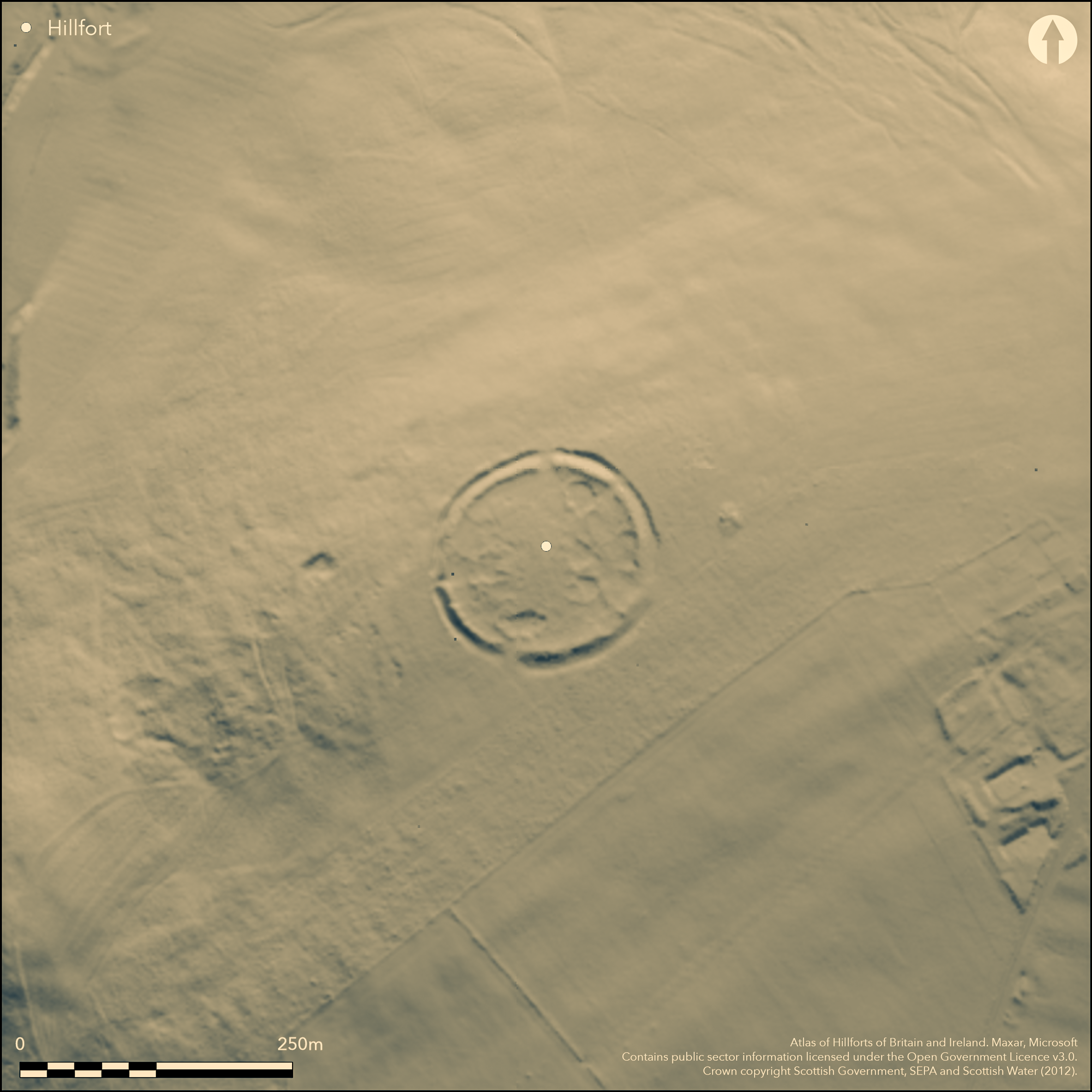
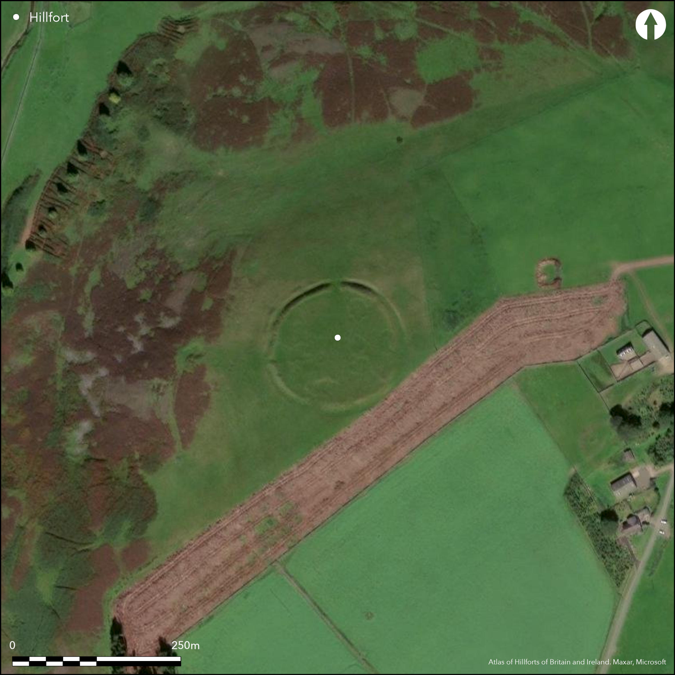
This fort stands on the rounded summit of Tollis Hill and though the ground falls away steeply to the Kelphope Burn on the W, it easily accessible from elsewhere. Nearly circular on plan, it measures about 100m in diameter from NE to SW by 95m transversely (0.72ha) within a rampart standing up to 3.5m in height above the bottom of its flanking ditch. A low counterscarp rampart can be seen around the NW half of the circuit and at a well preserved entrance on the W it returns around the terminals of the ditch to unite with the inner rampart; possible traces of a similar feature can also be seen at the entrance on the N, but in the opinion of Alexander Curle, who visited in 1908, James Hewat Craw, who drew up a plan about 1912 (RCAHMS 1909, 40, no.196; 1915, 119, no.223, fig 111), the gaps on the E and S had probably been broken through relatively recently. What may be a circular sheepfold lies on the N side of the interior, while scattered elsewhere are traces of four amorphous sunken areas up to 1m in depth and several adjacent circular stone-founded structures that are probably the remains of round-houses. Though the OS surveyor who visited in 1963 suggested these scoops may be no more than quarries, the presence of the round-houses implies that they are associated courts and yards.
Citizen Science: ✗
Reliability of Data: Confirmed
Reliability of Interpretation: Confirmed
X: -308778 Y: 7521333 (EPSG: 3857)
Longitude: -2.773804342794007 Latitude: 55.8132731938252 (EPSG:4326)
Country: Scotland
Current County or Unitary Authority: Scottish Borders
Historic County: Berwickshire
Current Parish/Community/Council/Townland: Lauder
Extensive quarrying within the interior
| Extant | ✓ |
| Cropmark | ✗ |
| Likely Destroyed | ✓ |
Was under heather until quite recently but the current grazing regime is under grass
| Woodland | ✗ |
| Commercial Forestry Plantation | ✗ |
| Parkland | ✗ |
| Pasture (Grazing) | ✓ |
| Arable | ✗ |
| Scrub/Bracken | ✗ |
| Bare Outcrop | ✗ |
| Heather/Moorland | ✓ |
| Heath | ✗ |
| Built-up | ✗ |
| Coastal Grassland | ✗ |
| Other | ✗ |
None
| Contour Fort | ✓ |
| Partial Contour Fort | ✗ |
| Promontory Fort | ✗ |
| Hillslope Fort | ✗ |
| Level Terrain Fort | ✗ |
| Marsh Fort | ✗ |
| Multiple Enclosure Fort | ✗ |
| Hilltop | ✓ |
| Coastal Promontory | ✗ |
| Inland Promontory | ✗ |
| Valley Bottom | ✗ |
| Knoll/Hillock/Outcrop | ✗ |
| Ridge | ✗ |
| Cliff/Plateau-edge/Scarp | ✗ |
| Hillslope | ✗ |
| Lowland | ✗ |
| Spur | ✗ |
Dominant Topographic Feature: None
| North | ✗ |
| Northeast | ✗ |
| East | ✗ |
| Southeast | ✗ |
| South | ✗ |
| Southwest | ✗ |
| West | ✗ |
| Northwest | ✗ |
| Level | ✓ |
Altitude: 373.0m
N/A
In the absence of excavation, there are neither stratified artefacts nor radiocarbon dates to provide a chronology for the defences.
Reliability: D - None
| Pre 1200BC | ✗ |
| 1200BC - 800BC | ✗ |
| 800BC - 400BC | ✗ |
| 400BC - AD50 | ✗ |
| AD50 - AD400 | ✗ |
| AD400 - AD 800 | ✗ |
| Post AD800 | ✗ |
| Unknown | ✓ |
| Pre Hillfort: | None |
| Post Hillfort: | If not quarries, the scooped areas within the interior are the remains of an overlying late Iron Age settlement |
Photographed by RCAHMS Aerial Survey Programme in 1982, 1983 and 1993
| 1st Identified Map Depiction (1755): | On General William Roy's Military Map of Scotland (1747-55) |
| 1st Identified Written Reference (1791): | Noted (Stat Acct, 1, 1791, 77) |
| Other (1857): | Annotated Camp on the 1st edition OS 25-inch map (Berwick 1862, sheet 7.16) |
| Other (1894): | Brief description by David Christison, who may not have visited (1895, 129) |
| Other (1908): | Description (RCAHMS 1909, 40, no.196) |
| Earthwork Survey (1912): | Plan drawn up by James Hewat Craw, possibly as early as 1910 (RCAHMS 1915, 119, no.223, fig 111; RCAHMS BWD 19/1; BWD 19/1/9) |
| Other (1936): | Scheduled |
| Other (1963): | Visited by the OS |
| Other (1979): | Surveyed at 1:10,000 by the OS |
Apart from a ring-bank that may be a later sheepfold, there are four possible scooped courts or yards with adjacent traces of several stone-founded hut-circles
None
| None | ✓ |
| Spring | ✗ |
| Stream | ✗ |
| Pool | ✗ |
| Flush | ✗ |
| Well | ✗ |
| Other | ✗ |
At least four scooped areas that are either late Iron Age yards or more recent quarries
| No Known Features | ✗ |
| Round Stone Structures | ✓ |
| Rectangular Stone Structures | ✗ |
| Curvilinear Platforms | ✗ |
| Other Roundhouse Evidence | ✗ |
| Pits | ✗ |
| Quarry Hollows | ✗ |
| Other | ✓ |
None
| No Known Excavation | ✓ |
| Pits | ✗ |
| Postholes | ✗ |
| Roundhouses | ✗ |
| Rectangular Structures | ✗ |
| Roads/Tracks | ✗ |
| Quarry Hollows | ✗ |
| Other | ✗ |
| Nothing Found | ✗ |
None
| No Known Geophysics | ✓ |
| Pits | ✗ |
| Roundhouses | ✗ |
| Rectangular Structures | ✗ |
| Roads/Tracks | ✗ |
| Quarry Hollows | ✗ |
| Other | ✗ |
| Nothing Found | ✗ |
None
| No Known Finds | ✓ |
| Pottery | ✗ |
| Metal | ✗ |
| Metalworking | ✗ |
| Human Bones | ✗ |
| Animal Bones | ✗ |
| Lithics | ✗ |
| Environmental | ✗ |
| Other | ✗ |
Traces of both the round-houses and the possible yards
| APs Not Checked | ✗ |
| None | ✗ |
| Roundhouses | ✓ |
| Rectangular Structures | ✗ |
| Pits | ✗ |
| Postholes | ✗ |
| Roads/Tracks | ✗ |
| Other | ✓ |
See main summary
| 5: | Two were identified as being relatively recent in 1908, but the gaps on the E and S, conforming to the cardinal points of the compass adopted by the entrances on the N and W, may simply have been widened from original entrances |
| 2: | None |
Guard Chambers: ✗
Chevaux de Frise: ✗
| 1. Passage-way/Corridor (North): | The counterscarp bank may have united with the inner rampart around the terminals of the ditch |
| 2. Passage-way/Corridor (West): | The counterscarp bank unites with the inner rampart around the terminals of the ditch |
Single rampart and ditch, but with a low counterscarp rampart also surviving around half the circuit
| Area 1: | 0.72ha. |
| Total: | 0.72ha. |
Total Footprint Area: 1.1ha.
None
| ✗ | None |
| ✓ | None |
| NE Quadrant: | 1 |
| SE Quadrant: | 1 |
| SW Quadrant: | 2 |
| NW Quadrant: | 2 |
| Total: | 2 |
| Partial Univallate | ✓ |
| Univallate | ✗ |
| Partial Bivallate | ✓ |
| Bivallate | ✗ |
| Partial Multivallate | ✗ |
| Multivallate | ✗ |
| Unknown | ✗ |
| Partial Univallate | ✗ |
| Univallate | ✗ |
| Partial Bivallate | ✗ |
| Bivallate | ✗ |
| Partial Multivallate | ✗ |
| Multivallate | ✗ |
None
| None | ✗ |
| Earthen Bank | ✓ |
| Stone Wall | ✗ |
| Rubble | ✗ |
| Wall-walk | ✗ |
| Evidence of Timber | ✗ |
| Vitrification | ✗ |
| Other Burning | ✗ |
| Palisade | ✗ |
| Counter Scarp Bank | ✗ |
| Berm | ✗ |
| Unfinished | ✗ |
| Other | ✗ |
None
| None | ✗ |
| Earthen Bank | ✗ |
| Stone Wall | ✗ |
| Murus Duplex | ✗ |
| Timber-framed | ✗ |
| Timber-laced | ✗ |
| Vitrification | ✗ |
| Other Burning | ✗ |
| Palisade | ✗ |
| Counter Scarp Bank | ✗ |
| Berm | ✗ |
| Unfinished | ✗ |
| No Known Excavation | ✓ |
| Other | ✗ |
| ✗ | None |
| ✓ | None |
Number of Ditches: 1
| ✗ | None |
Christison, D (1895) 'The forts of Selkirk, the Gala Water, the Southern slopes of the Lammermoors, and the north of Roxburgh'. Proc Soc Antiq Scot 29 (1894-50), 108-79
RCAHMS (1909) The Royal Commission on the Ancient and Historical Monuments and Constructions of Scotland. First report and Inventory of Monuments and Constructions in the County of Berwick. HMSO: Edinburgh.
RCAHMS (1915) The Royal Commission on the Ancient and Historical Monuments and Constructions of Scotland. Sixth report and Inventory of Monuments and Constructions in the County of Berwick (Revised Issue). HMSO: Edinburgh
Stat Acct (date) Statistical Account of Scotland: Drawn up from the Communications of the Ministers of the Different Parishes (Sinclair, J ed), 1791-99
Atlas of Hillforts:
Wikidata:
This work is licensed under CC BY-SA 4.0![]()
![]()
![]() and should be cited as:
and should be cited as:
Lock, Gary and Ralston, Ian. 2024. Atlas of Hillforts of Britain and Ireland. Available at: https://hillforts.arch.ox.ac.uk
Document Version 1.1