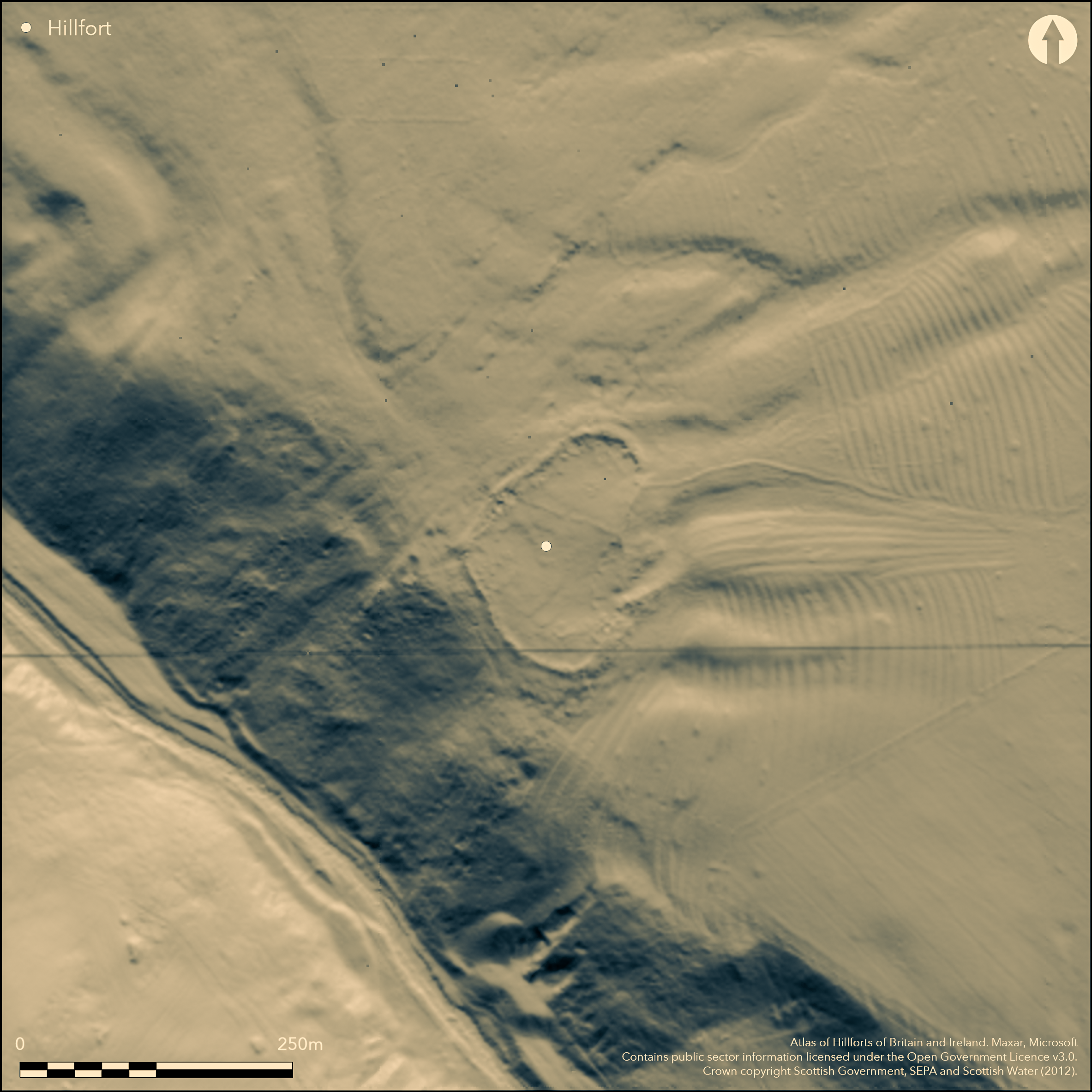
LiDAR 1m DTM Hillshade
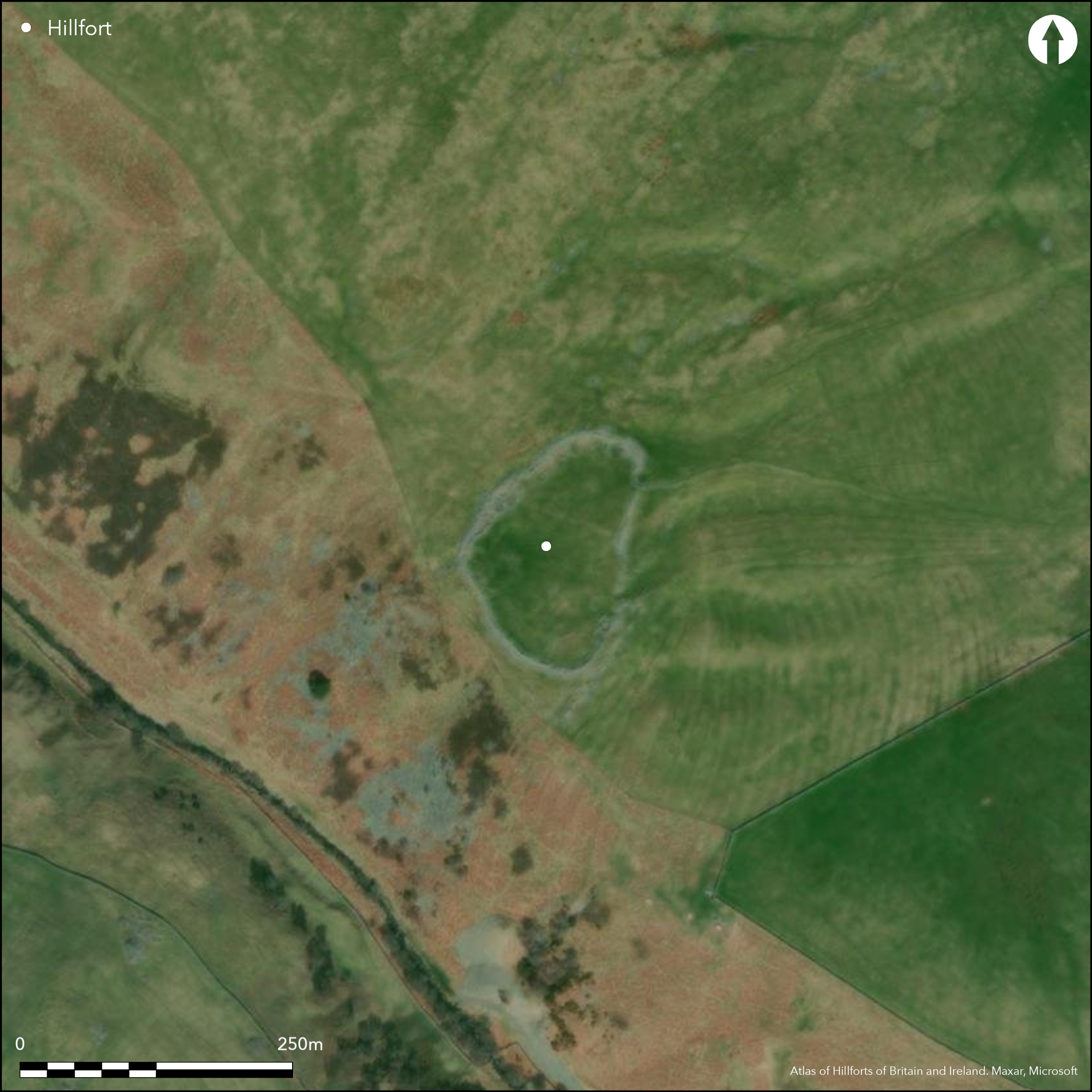
Satellite Imagery
LiDAR 1m DTM Hillshade
Satellite Imagery
Scroll left/right to view further images.
HER: Scottish Borders 56006 (None)
NMR: NT 55 SE 14 (56006)
SM: 370
NGR: NT 5745 5005
X: 357450 Y: 650050 (OSGB36)
This fort or fortified settlement is set out across the contours at the southern end of a broad spur, where the ground begins to fall away steeply to the Blythe Water. An irregular oval on plan, flattened along its E flank, it measures about 117m from NNE to SSW by 77m transversely within what has probably been a thick wall, now forming a bare mound of rubble some 5m in thickness by 0.9m in height. The entrance has probably been in the E side, where there are two gaps in the rubble. The presence of so much freely available stone has proved attractive for subsequent use with the erection of a much more recent wall along its inner edge to enclose the interior, and almost certainly associated with a series of well-preserved small circular huts and other enclosures let into the rubble all round the perimeter. Although Richard Feachem has suggested that some of these are the remains of late Iron Age round-houses (1963, 113), it is likely that this later occupation relates to medieval or later pasturage and grazings.
Citizen Science: ✗
Reliability of Data: Confirmed
Reliability of Interpretation: Confirmed
X: -298257 Y: 7507224 (EPSG: 3857)
Longitude: -2.6792923788510805 Latitude: 55.74199301419339 (EPSG:4326)
Country: Scotland
Current County or Unitary Authority: Scottish Borders
Historic County: Berwickshire
Current Parish/Community/Council/Townland: Lauder
None
| Extant | ✓ |
| Cropmark | ✗ |
| Likely Destroyed | ✗ |
None
| Woodland | ✗ |
| Commercial Forestry Plantation | ✗ |
| Parkland | ✗ |
| Pasture (Grazing) | ✓ |
| Arable | ✗ |
| Scrub/Bracken | ✗ |
| Bare Outcrop | ✗ |
| Heather/Moorland | ✓ |
| Heath | ✗ |
| Built-up | ✗ |
| Coastal Grassland | ✗ |
| Other | ✗ |
None
| Contour Fort | ✗ |
| Partial Contour Fort | ✗ |
| Promontory Fort | ✗ |
| Hillslope Fort | ✓ |
| Level Terrain Fort | ✗ |
| Marsh Fort | ✗ |
| Multiple Enclosure Fort | ✗ |
| Hilltop | ✗ |
| Coastal Promontory | ✗ |
| Inland Promontory | ✗ |
| Valley Bottom | ✗ |
| Knoll/Hillock/Outcrop | ✗ |
| Ridge | ✗ |
| Cliff/Plateau-edge/Scarp | ✗ |
| Hillslope | ✓ |
| Lowland | ✗ |
| Spur | ✗ |
Dominant Topographic Feature: None
| North | ✗ |
| Northeast | ✗ |
| East | ✗ |
| Southeast | ✗ |
| South | ✓ |
| Southwest | ✗ |
| West | ✗ |
| Northwest | ✗ |
| Level | ✗ |
Altitude: 293.0m
N/A
In the absence of modern excavation, there are neither stratified artefacts nor radiocarbon dates to provide a chronology for the defences.
Reliability: D - None
| Pre 1200BC | ✗ |
| 1200BC - 800BC | ✗ |
| 800BC - 400BC | ✗ |
| 400BC - AD50 | ✗ |
| AD50 - AD400 | ✗ |
| AD400 - AD 800 | ✗ |
| Post AD800 | ✗ |
| Unknown | ✓ |
| Pre Hillfort: | None |
| Post Hillfort: | Overlain by what are probably folds and bothies, though it has been suggested some are of late Iron Age date (Feachem 1963, 113) |
Photographed by RCAHMS Aerial Survey Programme in 1979, 1982, 1983, 1992, 1998 and 2010
| 1st Identified Map Depiction (1826): | T Sharp, Christopher Greenwood, William Fowler's map of The County of Berwick (1826) |
| Other (1857): | Depicted and named as a topographical feature on the OS 25-inch map (Berwick 1862, 20.2), but not annotated as an antiquity |
| Earthwork Survey (1870): | Plan and description by David Milne Home (1872, plate 29) |
| Excavation (1871): | By Lady John Scott and reported by David Milne Home (1872, 467) |
| Other (1873): | Description by James Tait (1884, 310-11) |
| Other (1882): | Scheduled |
| Earthwork Survey (1894): | Plan adapted from Milne Home and description by David Christison (1895,137-8) |
| Other (1897): | Annotated Fort on the 2nd edition OS 25-inch map (Berwick 1898, sheet 20.2) |
| Earthwork Survey (1902): | Sketch plan and description by Francis Lynn (1902, plate 22) |
| Other (1908): | Description (RCAHMS 1909, 39, no.192) |
| Earthwork Survey (1914): | Plan and description (RCAHMS 1915, 115-16, no.218, fig 107; RCAHMS BWD 16/1) |
| Other (1950): | Description during RCAHMS Survey of Marginal Lands |
| Other (1955): | Visited by the OS |
| Other (1960): | Re-Scheduled |
| Other (1962): | Surveyed at 1:2500 by the OS |
| Other (1979): | Surveyed at 1:10,000 by the OS |
The greater part of the interior is barren, barring an old dyke traversing it, but the dyke set round its edge and the huts set into the rubble of the wall suggest it serves as a focus for later grazing
None
| None | ✓ |
| Spring | ✗ |
| Stream | ✗ |
| Pool | ✗ |
| Flush | ✗ |
| Well | ✗ |
| Other | ✗ |
All the structures appear to post-date the wall and probably relate to a much later occupation in medieval or post-medieval times
| No Known Features | ✗ |
| Round Stone Structures | ✓ |
| Rectangular Stone Structures | ✓ |
| Curvilinear Platforms | ✗ |
| Other Roundhouse Evidence | ✗ |
| Pits | ✗ |
| Quarry Hollows | ✗ |
| Other | ✓ |
'Traces of fire' found within the structures (Milne Home 1872, 467)
| No Known Excavation | ✗ |
| Pits | ✗ |
| Postholes | ✗ |
| Roundhouses | ✗ |
| Rectangular Structures | ✗ |
| Roads/Tracks | ✗ |
| Quarry Hollows | ✗ |
| Other | ✓ |
| Nothing Found | ✗ |
None
| No Known Geophysics | ✓ |
| Pits | ✗ |
| Roundhouses | ✗ |
| Rectangular Structures | ✗ |
| Roads/Tracks | ✗ |
| Quarry Hollows | ✗ |
| Other | ✗ |
| Nothing Found | ✗ |
A 17th century Spanish coin found within the interior
| No Known Finds | ✓ |
| Pottery | ✗ |
| Metal | ✗ |
| Metalworking | ✗ |
| Human Bones | ✗ |
| Animal Bones | ✗ |
| Lithics | ✗ |
| Environmental | ✗ |
| Other | ✗ |
Series of later structures let into the rubble
| APs Not Checked | ✗ |
| None | ✗ |
| Roundhouses | ✗ |
| Rectangular Structures | ✗ |
| Pits | ✗ |
| Postholes | ✗ |
| Roads/Tracks | ✗ |
| Other | ✓ |
See main summary
| 2: | None |
| 2: | It is unclear whether either of the gaps in the E side is an original entrance |
Guard Chambers: ✗
Chevaux de Frise: ✗
Single wall
| Area 1: | 0.68ha. |
| Total: | 0.68ha. |
Total Footprint Area: 0.85ha.
None
| ✗ | None |
| ✓ | None |
| NE Quadrant: | 1 |
| SE Quadrant: | 1 |
| SW Quadrant: | 1 |
| NW Quadrant: | 1 |
| Total: | 1 |
| Partial Univallate | ✗ |
| Univallate | ✓ |
| Partial Bivallate | ✗ |
| Bivallate | ✗ |
| Partial Multivallate | ✗ |
| Multivallate | ✗ |
| Unknown | ✗ |
| Partial Univallate | ✗ |
| Univallate | ✗ |
| Partial Bivallate | ✗ |
| Bivallate | ✗ |
| Partial Multivallate | ✗ |
| Multivallate | ✗ |
None
| None | ✗ |
| Earthen Bank | ✗ |
| Stone Wall | ✗ |
| Rubble | ✓ |
| Wall-walk | ✗ |
| Evidence of Timber | ✗ |
| Vitrification | ✗ |
| Other Burning | ✗ |
| Palisade | ✗ |
| Counter Scarp Bank | ✗ |
| Berm | ✗ |
| Unfinished | ✗ |
| Other | ✗ |
None
| None | ✓ |
| Earthen Bank | ✗ |
| Stone Wall | ✗ |
| Murus Duplex | ✗ |
| Timber-framed | ✗ |
| Timber-laced | ✗ |
| Vitrification | ✗ |
| Other Burning | ✗ |
| Palisade | ✗ |
| Counter Scarp Bank | ✗ |
| Berm | ✗ |
| Unfinished | ✗ |
| No Known Excavation | ✗ |
| Other | ✗ |
| ✗ | None |
| ✗ | None |
Number of Ditches: None
| ✗ | None |
Christison, D (1895) 'The forts of Selkirk, the Gala Water, the Southern slopes of the Lammermoors, and the north of Roxburgh'. Proc Soc Antiq Scot 29 (1894-50), 108-79
Feachem, R W (1963) A guide to prehistoric Scotland. Batsford: London
Lynn, F (1902) 'The Haerfaulds'. Hist Berwickshire Natur Club 18 (1901-2), 272-4
Milne Home, D (1872) 'Notice of a number of circular stone huts, surrounded by a thick stone wall, enclosing one and a half acres, called the Harefaulds, in Lauder Parish, Berwickshire'. Proc Soc Antiq Scot 9 (1870-2), 465-72
RCAHMS (1909) The Royal Commission on the Ancient and Historical Monuments and Constructions of Scotland. First report and Inventory of Monuments and Constructions in the County of Berwick. HMSO: Edinburgh.
RCAHMS (1915) The Royal Commission on the Ancient and Historical Monuments and Constructions of Scotland. Sixth report and Inventory of Monuments and Constructions in the County of Berwick (Revised Issue). HMSO: Edinburgh
Tait, J (1884) 'On the Black Dyke and some British camps in the west of Berwickshire'. Hist Berwickshire Natur Club 10 (1882-4), 307-12
Atlas of Hillforts:
Wikidata:
This work is licensed under CC BY-SA 4.0![]()
![]()
![]() and should be cited as:
and should be cited as:
Lock, Gary and Ralston, Ian. 2024. Atlas of Hillforts of Britain and Ireland. Available at: https://hillforts.arch.ox.ac.uk
Document Version 1.1