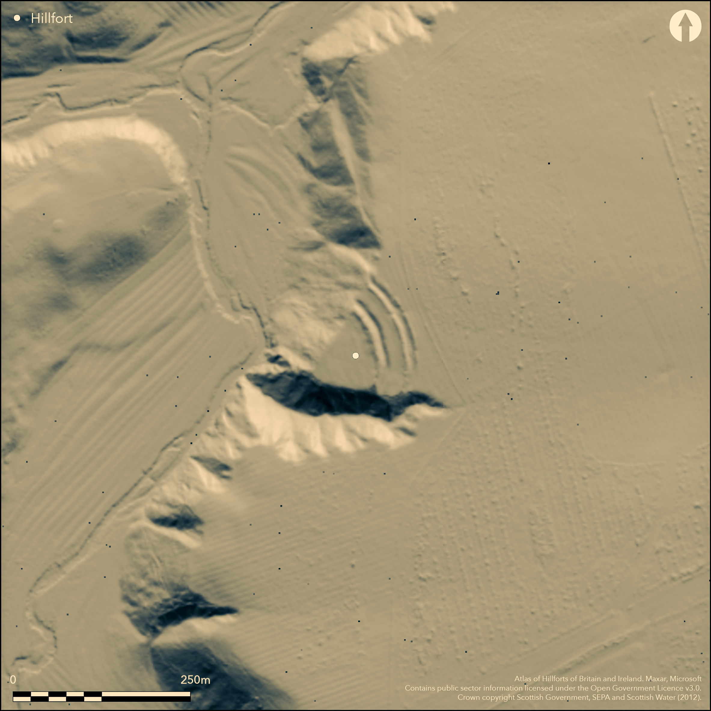
LiDAR 1m DTM Hillshade
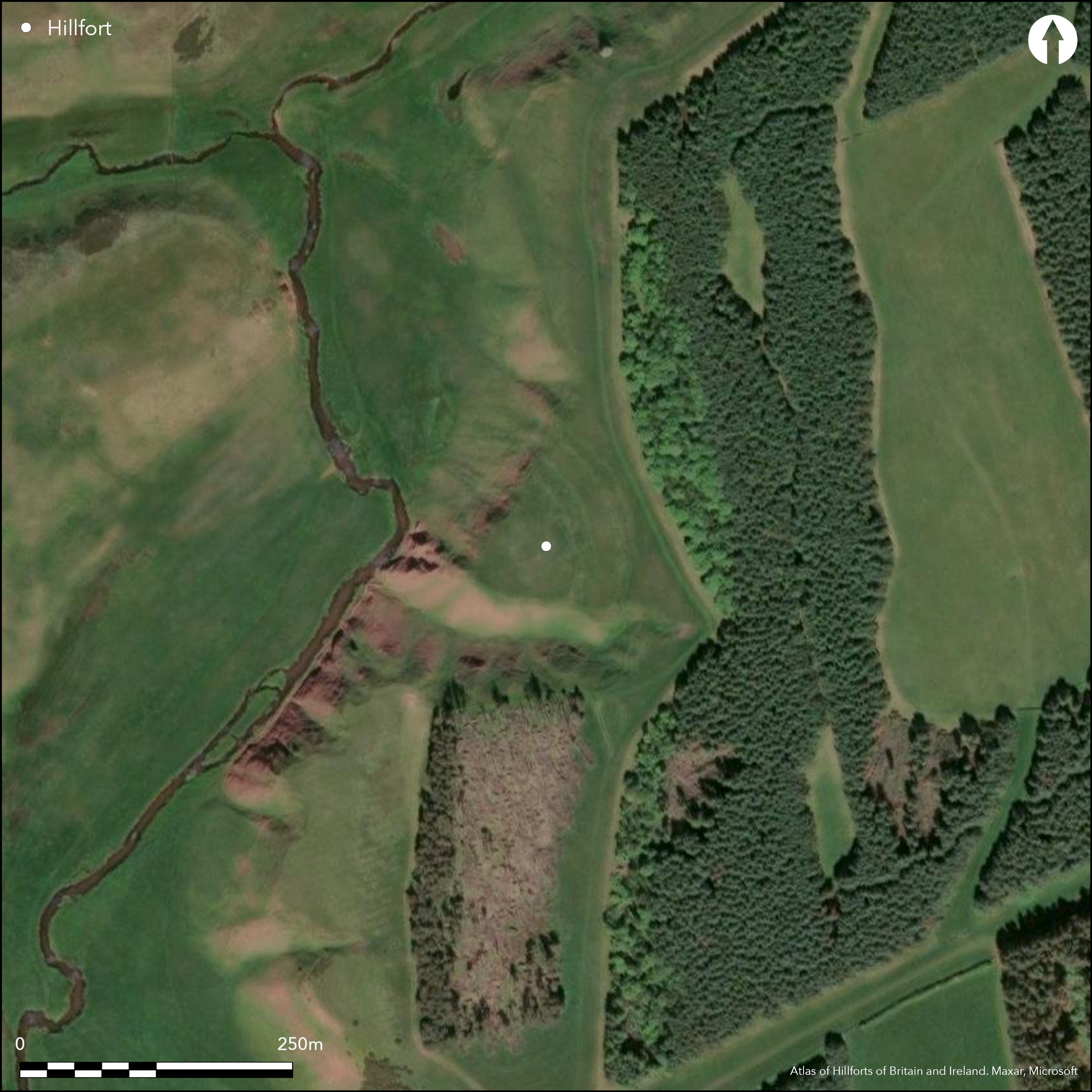
Satellite Imagery
LiDAR 1m DTM Hillshade
Satellite Imagery
Scroll left/right to view further images.
HER: Scottish Borders 57300 (None)
NMR: NT 64 NE 5 (57300)
SM: 363
NGR: NT 6935 4785
X: 369350 Y: 647850 (OSGB36)
A small fort is situated on a promontory formed where a gully known as Deil's Neuk cuts through the escarpment on the E side of the Blackadder Water gorge NW of Greenlaw. Triangular on plan, it measures internally 45m in length from NE to SW by a maximum of 63m transversely (0.18ha) immediately to the rear of the defences. These comprise two widely-spaced ramparts with external ditches drawn in an arc across the NE approaches, though whether they are contemporary is not known. The inner rampart still stands some 2m high internally and its ditch is up to 5.8m in breadth by 1.2m in depth, apparently dug in three straight segments; the outer rampart lies some 10m outside the inner ditch and is rather slighter, standing only 1m high, but its ditch is up to 5.9m in breadth by 0.8m in depth and is flanked by a traces of counterscarp bank; it encloses an overall area of 0.38ha. The position of the entrance is unknown and at both ends the ramparts and ditches terminate on the margins of the promontory, though on the N the ditch of the outer turns slightly outwards and disappears in the top of a gully running down the slope. The interior has been cultivated in ridges and is otherwise featureless. Outside the defences an old trackway terrace drops down the face of the escarpment into the gorge, presumably making for a ford at the confluence of the Blackadder Water and the Fangrist Burn.
Citizen Science: ✗
Reliability of Data: Confirmed
Reliability of Interpretation: Confirmed
X: -277131 Y: 7503495 (EPSG: 3857)
Longitude: -2.489511564642769 Latitude: 55.72312774719313 (EPSG:4326)
Country: Scotland
Current County or Unitary Authority: Scottish Borders
Historic County: Berwickshire
Current Parish/Community/Council/Townland: Greenlaw
None
| Extant | ✓ |
| Cropmark | ✗ |
| Likely Destroyed | ✗ |
None
| Woodland | ✗ |
| Commercial Forestry Plantation | ✗ |
| Parkland | ✗ |
| Pasture (Grazing) | ✓ |
| Arable | ✗ |
| Scrub/Bracken | ✗ |
| Bare Outcrop | ✗ |
| Heather/Moorland | ✓ |
| Heath | ✗ |
| Built-up | ✗ |
| Coastal Grassland | ✗ |
| Other | ✗ |
None
| Contour Fort | ✗ |
| Partial Contour Fort | ✗ |
| Promontory Fort | ✓ |
| Hillslope Fort | ✗ |
| Level Terrain Fort | ✗ |
| Marsh Fort | ✗ |
| Multiple Enclosure Fort | ✗ |
| Hilltop | ✗ |
| Coastal Promontory | ✗ |
| Inland Promontory | ✓ |
| Valley Bottom | ✗ |
| Knoll/Hillock/Outcrop | ✗ |
| Ridge | ✗ |
| Cliff/Plateau-edge/Scarp | ✗ |
| Hillslope | ✗ |
| Lowland | ✗ |
| Spur | ✗ |
Dominant Topographic Feature: None
| North | ✗ |
| Northeast | ✗ |
| East | ✗ |
| Southeast | ✗ |
| South | ✗ |
| Southwest | ✗ |
| West | ✗ |
| Northwest | ✗ |
| Level | ✓ |
Altitude: 206.0m
N/A
In the absence of excavation, there are neither stratified artefacts nor radiocarbon dates to provide a chronology for the defences.
Reliability: D - None
| Pre 1200BC | ✗ |
| 1200BC - 800BC | ✗ |
| 800BC - 400BC | ✗ |
| 400BC - AD50 | ✗ |
| AD50 - AD400 | ✗ |
| AD400 - AD 800 | ✗ |
| Post AD800 | ✗ |
| Unknown | ✓ |
| Pre Hillfort: | None |
| Post Hillfort: | Cultivated with rigs |
A massive silver chain was reported to have been found in the late 18th century at the fort by the Rev Abraham Home (NSA, 14, Berwickshire, 43), but subsequent enquiries suggest that it was discovered nearby in the linear earthwork known as Heriot's Dyke (Elliot 1872, 18n; Smith 1872, 327-8). The fort was photographed by RCAHMS Aerial Survey Programme in 1993 and 2008
| 1st Identified Map Depiction (1771): | Concentric ring on a hill symbol on Andrew and Mostyn Armstrong's Map of the County of Berwick (1771) |
| 1st Identified Written Reference (1834): | Noted (NSA, 14, Berwickshire, 43) |
| Other (1857): | Annotated Camp on the 1st edition OS 25-inch map (Berwick 1862, sheet 21.7) |
| Earthwork Survey (1894): | Sketch-plan and description by David Christison (1895, 148-50, fig 19) |
| Other (1905): | Description by Robert Gibson (1905, 250-2) |
| Other (1908): | Description (RCAHMS 1909, 32, no.159) |
| Other (1912): | Plan by James Hewat Craw and description (RCAHMS 1915, 94-5, no.171, fig 90; RCAHMS BWD 12/1) |
| Other (1927): | Scheduled |
| Other (1956): | Visited by the OS |
| Other (1961): | Re-Scheduled |
| Other (1963): | Revised at 1:2500 by the OS |
| Other (1979): | Description by RCAHMS |
Cultivated with rigs and otherwise featureless
None
| None | ✓ |
| Spring | ✗ |
| Stream | ✗ |
| Pool | ✗ |
| Flush | ✗ |
| Well | ✗ |
| Other | ✗ |
None
| No Known Features | ✓ |
| Round Stone Structures | ✗ |
| Rectangular Stone Structures | ✗ |
| Curvilinear Platforms | ✗ |
| Other Roundhouse Evidence | ✗ |
| Pits | ✗ |
| Quarry Hollows | ✗ |
| Other | ✗ |
None
| No Known Excavation | ✓ |
| Pits | ✗ |
| Postholes | ✗ |
| Roundhouses | ✗ |
| Rectangular Structures | ✗ |
| Roads/Tracks | ✗ |
| Quarry Hollows | ✗ |
| Other | ✗ |
| Nothing Found | ✗ |
None
| No Known Geophysics | ✓ |
| Pits | ✗ |
| Roundhouses | ✗ |
| Rectangular Structures | ✗ |
| Roads/Tracks | ✗ |
| Quarry Hollows | ✗ |
| Other | ✗ |
| Nothing Found | ✗ |
None
| No Known Finds | ✓ |
| Pottery | ✗ |
| Metal | ✗ |
| Metalworking | ✗ |
| Human Bones | ✗ |
| Animal Bones | ✗ |
| Lithics | ✗ |
| Environmental | ✗ |
| Other | ✗ |
NO APPARENT FEATURES
| APs Not Checked | ✗ |
| None | ✓ |
| Roundhouses | ✗ |
| Rectangular Structures | ✗ |
| Pits | ✗ |
| Postholes | ✗ |
| Roads/Tracks | ✗ |
| Other | ✗ |
See main summary
| 0: | None |
| 2: | None known |
Guard Chambers: ✗
Chevaux de Frise: ✗
Two widely spaced ramparts and ditches cutting off a promontory, the outer possibly with a counterscarp bank, though the latter may be no more than a post-medieval field-bank
| Area 1: | 0.18ha. |
| Area 2: | 0.38ha. |
| Total: | 0.38ha. |
Total Footprint Area: 0.49ha.
None
| ✓ | In 1979 RCAHMS investigators observed traces of low swellings 11.3m and 5.9m broad respectively beneath the inner and outer ramparts, which they speculated were possibly the spread remains of earlier ramparts |
| ✗ | None |
| NE Quadrant: | 2 |
| SE Quadrant: | 0 |
| SW Quadrant: | 0 |
| NW Quadrant: | 0 |
| Total: | 2 |
| Partial Univallate | ✗ |
| Univallate | ✗ |
| Partial Bivallate | ✓ |
| Bivallate | ✗ |
| Partial Multivallate | ✗ |
| Multivallate | ✗ |
| Unknown | ✗ |
| Partial Univallate | ✗ |
| Univallate | ✗ |
| Partial Bivallate | ✗ |
| Bivallate | ✗ |
| Partial Multivallate | ✗ |
| Multivallate | ✗ |
None
| None | ✗ |
| Earthen Bank | ✓ |
| Stone Wall | ✗ |
| Rubble | ✗ |
| Wall-walk | ✗ |
| Evidence of Timber | ✗ |
| Vitrification | ✗ |
| Other Burning | ✗ |
| Palisade | ✗ |
| Counter Scarp Bank | ✓ |
| Berm | ✗ |
| Unfinished | ✗ |
| Other | ✗ |
None
| None | ✗ |
| Earthen Bank | ✗ |
| Stone Wall | ✗ |
| Murus Duplex | ✗ |
| Timber-framed | ✗ |
| Timber-laced | ✗ |
| Vitrification | ✗ |
| Other Burning | ✗ |
| Palisade | ✗ |
| Counter Scarp Bank | ✗ |
| Berm | ✗ |
| Unfinished | ✗ |
| No Known Excavation | ✓ |
| Other | ✗ |
| ✗ | None |
| ✓ | None |
Number of Ditches: 2
| ✗ | None |
Christison, D (1895) 'The forts of Selkirk, the Gala Water, the Southern slopes of the Lammermoors, and the north of Roxburgh'. Proc Soc Antiq Scot 29 (1894-50), 108-79
Elliot, W (1872) 'Anniversary address, delivered at Berwick, on the 30th of September 1869'. Hist Berwickshire Natur Club 6 (1869-72), 1-53
NSA (1834-1845) The new statistical account of Scotland by the ministers of the respective parishes under the superintendence of a committee of the society for the benefit of the sons and daughters of the clergy.
RCAHMS (1909) The Royal Commission on the Ancient and Historical Monuments and Constructions of Scotland. First report and Inventory of Monuments and Constructions in the County of Berwick. HMSO: Edinburgh.
RCAHMS (1915) The Royal Commission on the Ancient and Historical Monuments and Constructions of Scotland. Sixth report and Inventory of Monuments and Constructions in the County of Berwick (Revised Issue). HMSO: Edinburgh
Smith, J A (1875) 'Notice of a silver chain or girdle, the property of Thomas Simson, of Blainslie, Esq., Berwickshire; another, in the University of Aberdeen; and of other ancient Scottish silver chains'. Proc Soc Antiq Scot 10 (1872-4), 321-47
Atlas of Hillforts:
Wikidata:
This work is licensed under CC BY-SA 4.0![]()
![]()
![]() and should be cited as:
and should be cited as:
Lock, Gary and Ralston, Ian. 2024. Atlas of Hillforts of Britain and Ireland. Available at: https://hillforts.arch.ox.ac.uk
Document Version 1.1