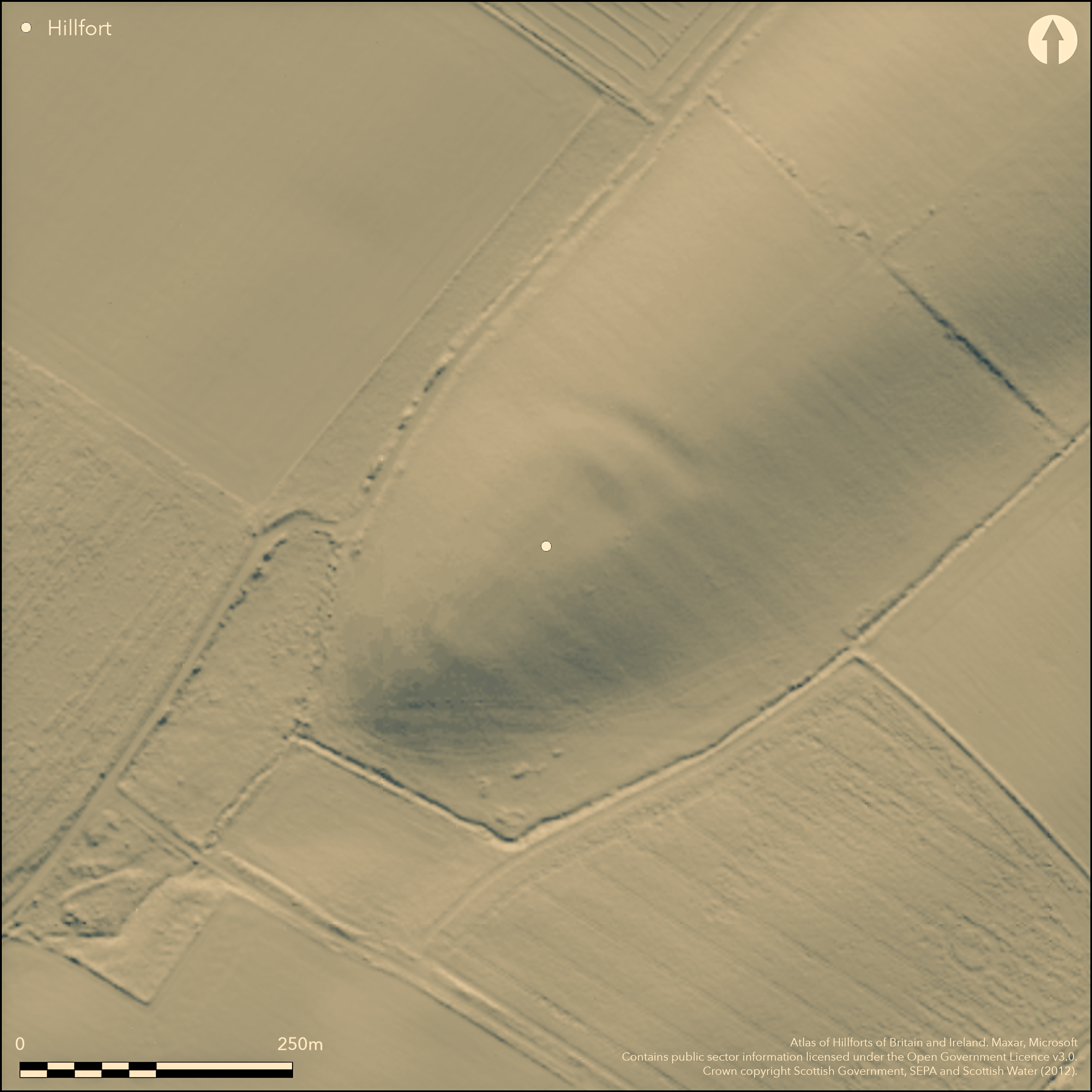
LiDAR 1m DTM Hillshade
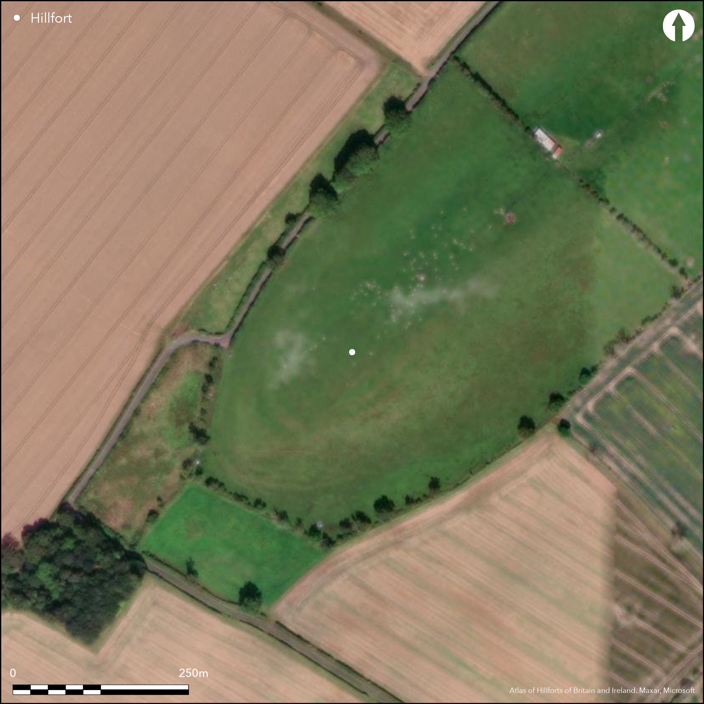
Satellite Imagery
LiDAR 1m DTM Hillshade
Satellite Imagery
Scroll left/right to view further images.
HER: Scottish Borders 58567 (None)
NMR: NT 74 SW 8 (58567)
SM: None
NGR: NT 7430 4191
X: 374300 Y: 641910 (OSGB36)
Parchmarks in grass and upstanding traces of the defences reveal the site of a substantial fort on the gently sloping crest of a ridge dropping down SW from the summit. Oval on plan, the massive defences are best preserved on the NE, where they traverse the crest, comprising two broad ditches with upstanding traces of not only the inner rampart but also a counterscarp rampart accompanying the outer ditch, which is up to 16m in breadth and still 1m in depth; together they form a belt about 45m deep. The inner of two concentric scarps visible at the SW end probably marks the line of the inner rampart and the parchmarks reveal the two ditches completing the circuit. Resolving the various features noted on the ground and visible on aerial photographs and satellite imagery is fraught, but assuming that the innermost features depicted by James Hewat Craw about 1912 (RCAHMS 1915, 79, no.142, fig 76) broadly conform to the line of the inner rampart, the interior measures about 100m from NE to SW by 70m transversely (0.55ha). The parchmarks are too diffuse and faint to be certain of the position of any entrances, but on the ENE the parchmark of the outer ditch appears to terminate abruptly on the SE margin of the ridge, possibly indicating a causeway at this point. No features are visible within the interior.
Citizen Science: ✗
Reliability of Data: Confirmed
Reliability of Interpretation: Confirmed
X: -268297 Y: 7493009 (EPSG: 3857)
Longitude: -2.4101498092390923 Latitude: 55.67004509984688 (EPSG:4326)
Country: Scotland
Current County or Unitary Authority: Scottish Borders
Historic County: Berwickshire
Current Parish/Community/Council/Townland: Eccles
None
| Extant | ✓ |
| Cropmark | ✗ |
| Likely Destroyed | ✗ |
None
| Woodland | ✗ |
| Commercial Forestry Plantation | ✗ |
| Parkland | ✗ |
| Pasture (Grazing) | ✓ |
| Arable | ✓ |
| Scrub/Bracken | ✗ |
| Bare Outcrop | ✗ |
| Heather/Moorland | ✗ |
| Heath | ✗ |
| Built-up | ✗ |
| Coastal Grassland | ✗ |
| Other | ✗ |
None
| Contour Fort | ✗ |
| Partial Contour Fort | ✓ |
| Promontory Fort | ✗ |
| Hillslope Fort | ✗ |
| Level Terrain Fort | ✗ |
| Marsh Fort | ✗ |
| Multiple Enclosure Fort | ✗ |
| Hilltop | ✗ |
| Coastal Promontory | ✗ |
| Inland Promontory | ✗ |
| Valley Bottom | ✗ |
| Knoll/Hillock/Outcrop | ✗ |
| Ridge | ✗ |
| Cliff/Plateau-edge/Scarp | ✗ |
| Hillslope | ✓ |
| Lowland | ✗ |
| Spur | ✓ |
Dominant Topographic Feature: None
| North | ✗ |
| Northeast | ✗ |
| East | ✗ |
| Southeast | ✗ |
| South | ✗ |
| Southwest | ✓ |
| West | ✗ |
| Northwest | ✗ |
| Level | ✗ |
Altitude: 99.0m
N/A
In the absence of excavation, there are neither stratified artefacts nor radiocarbon dates to provide a chronology for the defences.
Reliability: D - None
| Pre 1200BC | ✗ |
| 1200BC - 800BC | ✗ |
| 800BC - 400BC | ✗ |
| 400BC - AD50 | ✗ |
| AD50 - AD400 | ✗ |
| AD400 - AD 800 | ✗ |
| Post AD800 | ✗ |
| Unknown | ✓ |
| Pre Hillfort: | None |
| Post Hillfort: | Ploughed down |
Photographed by R Strathie and RCAHMS Aerial Survey Programme in 1995
| 1st Identified Map Depiction (1771): | Concentric ring on a hill symbol on Andrew and Mostyn Armstrong's Map of the County of Berwick (1771) |
| 1st Identified Written Reference (1834): | Noted (NSA, ii, Berwickshire, 56-7) |
| Other (1858): | Annotated Camp on the 1st edition OS 25-inch map (Berwick 1862, sheet 28.5) |
| Other (1875): | Brief description by a Mr Hood (Hardy 1884, 371) |
| Other (1908): | Description (RCAHMS 1909, 26, no.134 |
| Earthwork Survey (1912): | Plan by James Hewat Craw and description (RCAHMS 1915, 79, no.142, fig 76; RCAHMS BWD 17/1 & DP229125; BWD 17/1/7) |
| Other (1966): | Resurveyed at 1:2500 by the OS |
| Other (1979): | Description by RCAHMS investigators, who without the aid of the aerial photographs misunderstood the character of the defences at the NE end, the berm representing the inner ditch. |
Featureless
None
| None | ✓ |
| Spring | ✗ |
| Stream | ✗ |
| Pool | ✗ |
| Flush | ✗ |
| Well | ✗ |
| Other | ✗ |
None
| No Known Features | ✓ |
| Round Stone Structures | ✗ |
| Rectangular Stone Structures | ✗ |
| Curvilinear Platforms | ✗ |
| Other Roundhouse Evidence | ✗ |
| Pits | ✗ |
| Quarry Hollows | ✗ |
| Other | ✗ |
None
| No Known Excavation | ✓ |
| Pits | ✗ |
| Postholes | ✗ |
| Roundhouses | ✗ |
| Rectangular Structures | ✗ |
| Roads/Tracks | ✗ |
| Quarry Hollows | ✗ |
| Other | ✗ |
| Nothing Found | ✗ |
None
| No Known Geophysics | ✓ |
| Pits | ✗ |
| Roundhouses | ✗ |
| Rectangular Structures | ✗ |
| Roads/Tracks | ✗ |
| Quarry Hollows | ✗ |
| Other | ✗ |
| Nothing Found | ✗ |
None
| No Known Finds | ✓ |
| Pottery | ✗ |
| Metal | ✗ |
| Metalworking | ✗ |
| Human Bones | ✗ |
| Animal Bones | ✗ |
| Lithics | ✗ |
| Environmental | ✗ |
| Other | ✗ |
NO APPARENT FEATURES
| APs Not Checked | ✗ |
| None | ✓ |
| Roundhouses | ✗ |
| Rectangular Structures | ✗ |
| Pits | ✗ |
| Postholes | ✗ |
| Roads/Tracks | ✗ |
| Other | ✗ |
See main summary
| 1: | The whole circuit has been ploughed down and there are no clear gaps |
| 2: | Possible traces of an entrance on the ENE |
Guard Chambers: ✗
Chevaux de Frise: ✗
| 1. Simple Gap (East): | No real detail visible |
Three ramparts with intermediate ditches where most clearly defined on the crest of the ridge on the NE
| Area 1: | 0.55ha. |
| Total: | 0.55ha. |
Total Footprint Area: Noneha.
None
| ✗ | None |
| ✓ | None |
| NE Quadrant: | 3 |
| SE Quadrant: | 2 |
| SW Quadrant: | 2 |
| NW Quadrant: | 2 |
| Total: | 3 |
| Partial Univallate | ✗ |
| Univallate | ✗ |
| Partial Bivallate | ✓ |
| Bivallate | ✗ |
| Partial Multivallate | ✓ |
| Multivallate | ✗ |
| Unknown | ✗ |
| Partial Univallate | ✗ |
| Univallate | ✗ |
| Partial Bivallate | ✗ |
| Bivallate | ✗ |
| Partial Multivallate | ✗ |
| Multivallate | ✗ |
None
| None | ✗ |
| Earthen Bank | ✓ |
| Stone Wall | ✗ |
| Rubble | ✗ |
| Wall-walk | ✗ |
| Evidence of Timber | ✗ |
| Vitrification | ✗ |
| Other Burning | ✗ |
| Palisade | ✗ |
| Counter Scarp Bank | ✗ |
| Berm | ✗ |
| Unfinished | ✗ |
| Other | ✗ |
None
| None | ✗ |
| Earthen Bank | ✗ |
| Stone Wall | ✗ |
| Murus Duplex | ✗ |
| Timber-framed | ✗ |
| Timber-laced | ✗ |
| Vitrification | ✗ |
| Other Burning | ✗ |
| Palisade | ✗ |
| Counter Scarp Bank | ✗ |
| Berm | ✗ |
| Unfinished | ✗ |
| No Known Excavation | ✓ |
| Other | ✗ |
| ✗ | None |
| ✓ | None |
Number of Ditches: 2
| ✗ | None |
Hardy, J (1885) 'On the ancient cross at Crosshall, in the Parish of Eccles, Berwickshire'. Hist Berwickshire Natur Club 10 (1882-4), 366-72
NSA (1834-1845) The new statistical account of Scotland by the ministers of the respective parishes under the superintendence of a committee of the society for the benefit of the sons and daughters of the clergy.
RCAHMS (1909) The Royal Commission on the Ancient and Historical Monuments and Constructions of Scotland. First report and Inventory of Monuments and Constructions in the County of Berwick. HMSO: Edinburgh.
RCAHMS (1915) The Royal Commission on the Ancient and Historical Monuments and Constructions of Scotland. Sixth report and Inventory of Monuments and Constructions in the County of Berwick (Revised Issue). HMSO: Edinburgh
Atlas of Hillforts:
Wikidata:
This work is licensed under CC BY-SA 4.0![]()
![]()
![]() and should be cited as:
and should be cited as:
Lock, Gary and Ralston, Ian. 2024. Atlas of Hillforts of Britain and Ireland. Available at: https://hillforts.arch.ox.ac.uk
Document Version 1.1