LiDAR 1m DTM Hillshade
Satellite Imagery
LiDAR 1m DTM Hillshade
Satellite Imagery
Scroll left/right to view further images.
HER: Scottish Borders 58640 (None)
NMR: NT 75 SE 2 (58640)
SM: 3939
NGR: NT 7850 5468
X: 378500 Y: 654680 (OSGB36)
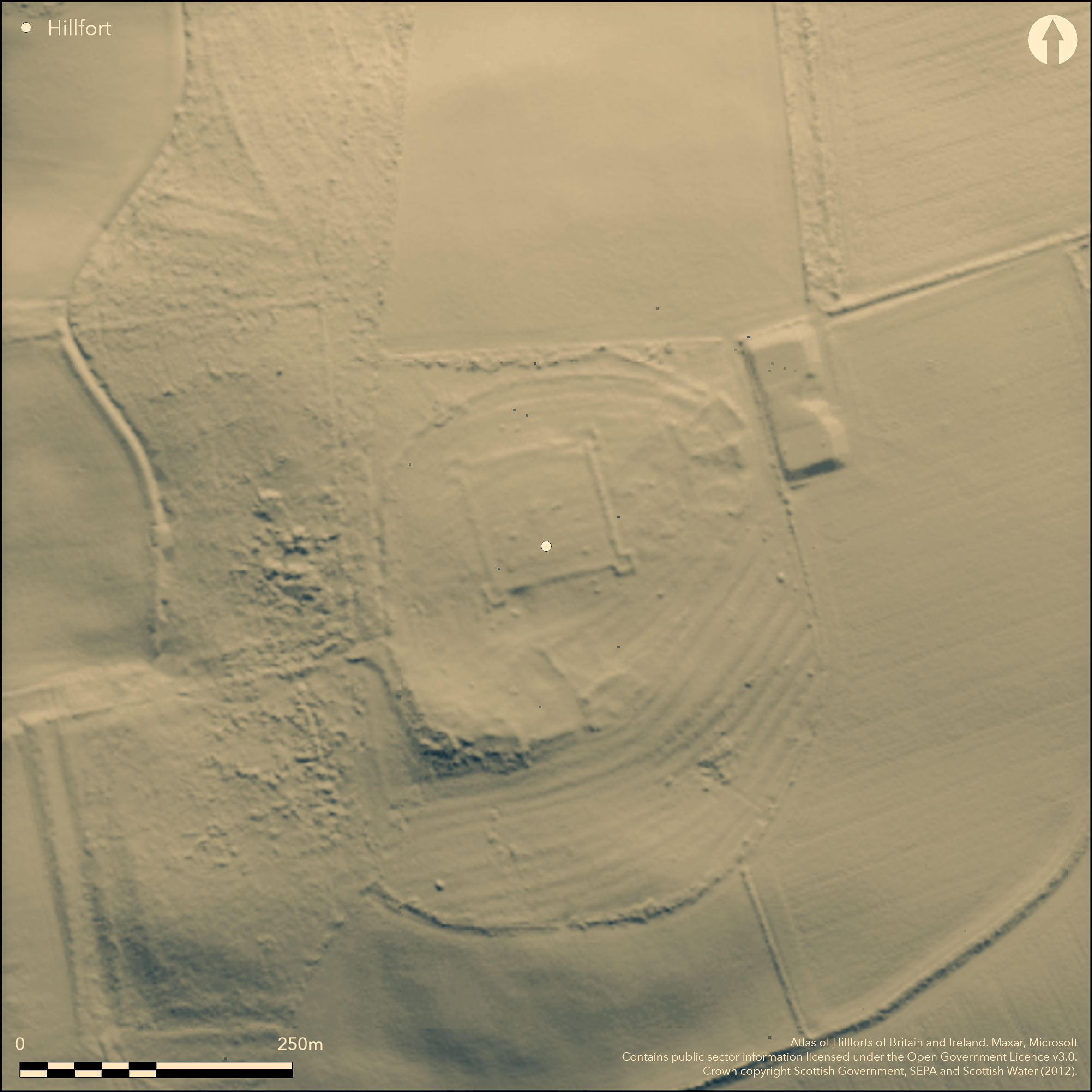
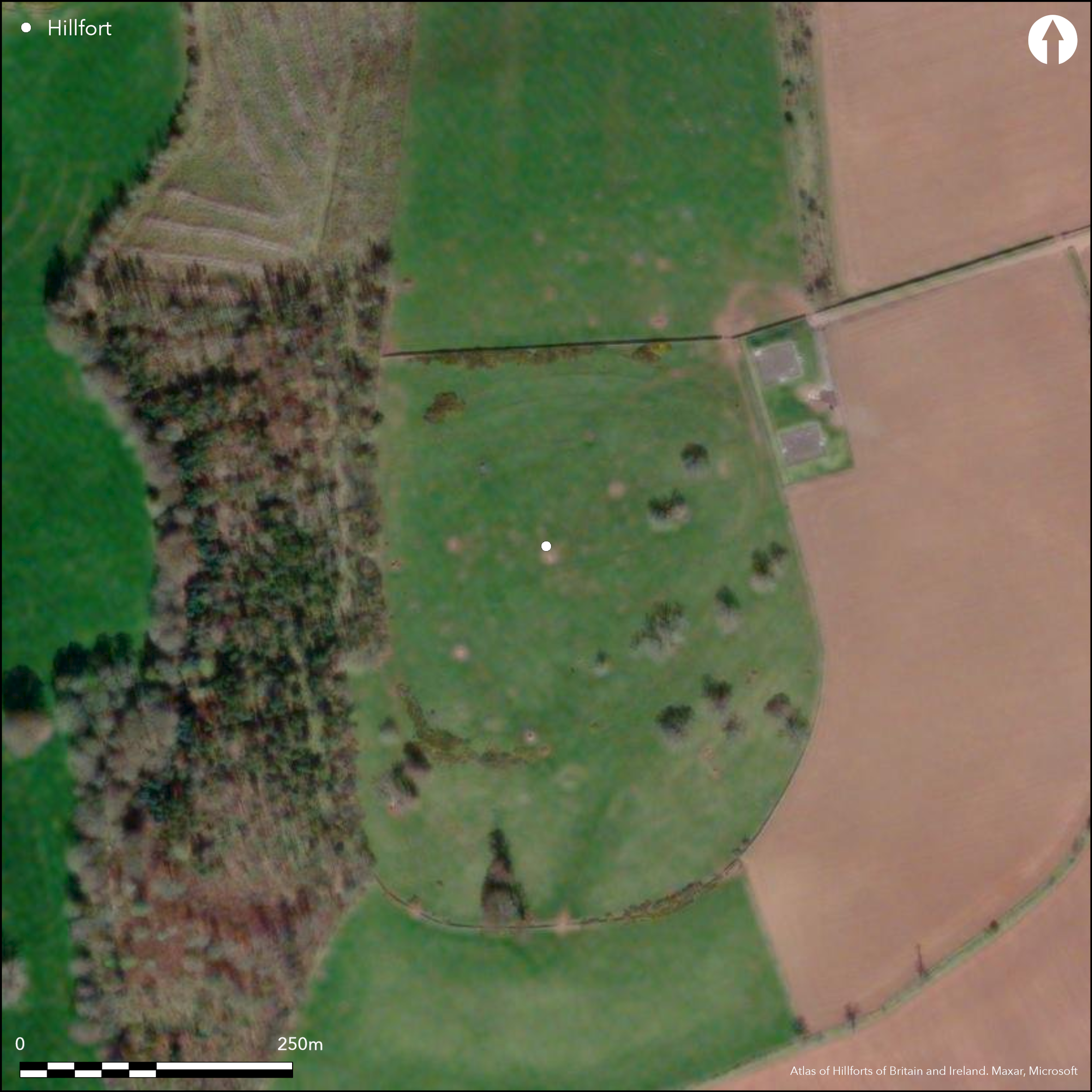
This fort is situated on the rounded summit of Duns Law immediately overlooking the town from the N. Elliptical on plan, it measures 193m from NE to SW by 162m transversely (2.5ha) within the remains of two ramparts, though these have been severely reduced by subsequent occupation and extensive ridged cultivation both within the interior and around the periphery. Within the interior, the most obvious feature is a 17th-century military field work measuring about 60m square internally and equipped with bastions at each of the corners, but a series of rectilinear courts and yards can also be seen overlying the defences on the ENE and S, within which at least eight rectangular building platforms are visible. In addition there are at least three stone-founded round-houses and several other platforms, which probably relate to a late Iron Age occupation of the fort. The only possible entrance into the fort lies amongst the yards on the ENE.
Citizen Science: ✗
Reliability of Data: Confirmed
Reliability of Interpretation: Confirmed
X: -260976 Y: 7515732 (EPSG: 3857)
Longitude: -2.344385463320583 Latitude: 55.784989786095835 (EPSG:4326)
Country: Scotland
Current County or Unitary Authority: Scottish Borders
Historic County: Berwickshire
Current Parish/Community/Council/Townland: Duns
None
| Extant | ✓ |
| Cropmark | ✗ |
| Likely Destroyed | ✗ |
None
| Woodland | ✗ |
| Commercial Forestry Plantation | ✗ |
| Parkland | ✗ |
| Pasture (Grazing) | ✓ |
| Arable | ✗ |
| Scrub/Bracken | ✗ |
| Bare Outcrop | ✗ |
| Heather/Moorland | ✗ |
| Heath | ✗ |
| Built-up | ✗ |
| Coastal Grassland | ✗ |
| Other | ✗ |
None
| Contour Fort | ✓ |
| Partial Contour Fort | ✗ |
| Promontory Fort | ✗ |
| Hillslope Fort | ✗ |
| Level Terrain Fort | ✗ |
| Marsh Fort | ✗ |
| Multiple Enclosure Fort | ✗ |
| Hilltop | ✓ |
| Coastal Promontory | ✗ |
| Inland Promontory | ✗ |
| Valley Bottom | ✗ |
| Knoll/Hillock/Outcrop | ✗ |
| Ridge | ✗ |
| Cliff/Plateau-edge/Scarp | ✗ |
| Hillslope | ✗ |
| Lowland | ✗ |
| Spur | ✗ |
Dominant Topographic Feature: None
| North | ✗ |
| Northeast | ✗ |
| East | ✗ |
| Southeast | ✗ |
| South | ✗ |
| Southwest | ✗ |
| West | ✗ |
| Northwest | ✗ |
| Level | ✓ |
Altitude: 218.0m
N/A
In the absence of excavation, there are neither stratified artefacts nor radiocarbon dates to provide a chronology for the defences.
Reliability: D - None
| Pre 1200BC | ✗ |
| 1200BC - 800BC | ✗ |
| 800BC - 400BC | ✗ |
| 400BC - AD50 | ✗ |
| AD50 - AD400 | ✗ |
| AD400 - AD 800 | ✗ |
| Post AD800 | ✗ |
| Unknown | ✓ |
| Pre Hillfort: | A cist is suposed to have been found at 'Dunselaw' sometime between 1833 and 1853 (Stevenson 1856, 156) |
| Post Hillfort: | Certainly occupied by a small 17th century artillery fortification thought to have been erected by General Leslie in 1639. A series of rectilinear yards overlying the defences are probably the remains of a late Iron Age and medieval occupation of the fort |
Photographed by John Dent in 1992, and by RCAHMS Aerial Survey Programme in 1980, 2005 and 2008
| 1st Identified Map Depiction (1857): | Annotated Camp on the 1st edition OS 25-inch map (Berwick 1862, sheet 16.7) |
| Other (1894): | Description by David Christison (1895, 154-5) |
| Other (1908): | Description (RCAHMS 1909, 23-4, no.120) |
| Earthwork Survey (1912): | Plan by James Hewat Craw and description (RCAHMS 1915, 66-7, no.119, fig 65; RCAHMS BWD 15/1; BWD 15/1/4 & DP225501) |
| Other (1968): | Resurveyed at 1:2500 by the OS |
| Other (1977): | Scheduled |
| Other (1979): | Description by RCAHMS |
| Other (1996): | Re-Scheduled |
The defences and interior on the ENE and S are overlain by a series of rectilinear yards in which there are at least eight rectangular building platforms in addition to at least three stone-founded round-houses and several other circular platforms. Otherwise there are tracers of ridged cultivation and General Leslie's fortification of 1639
None
| None | ✓ |
| Spring | ✗ |
| Stream | ✗ |
| Pool | ✗ |
| Flush | ✗ |
| Well | ✗ |
| Other | ✗ |
Lying within a series of rectilinear yards overlying the defences
| No Known Features | ✗ |
| Round Stone Structures | ✓ |
| Rectangular Stone Structures | ✓ |
| Curvilinear Platforms | ✓ |
| Other Roundhouse Evidence | ✗ |
| Pits | ✗ |
| Quarry Hollows | ✗ |
| Other | ✓ |
None
| No Known Excavation | ✓ |
| Pits | ✗ |
| Postholes | ✗ |
| Roundhouses | ✗ |
| Rectangular Structures | ✗ |
| Roads/Tracks | ✗ |
| Quarry Hollows | ✗ |
| Other | ✗ |
| Nothing Found | ✗ |
None
| No Known Geophysics | ✓ |
| Pits | ✗ |
| Roundhouses | ✗ |
| Rectangular Structures | ✗ |
| Roads/Tracks | ✗ |
| Quarry Hollows | ✗ |
| Other | ✗ |
| Nothing Found | ✗ |
None
| No Known Finds | ✓ |
| Pottery | ✗ |
| Metal | ✗ |
| Metalworking | ✗ |
| Human Bones | ✗ |
| Animal Bones | ✗ |
| Lithics | ✗ |
| Environmental | ✗ |
| Other | ✗ |
Only the rectilinear yards are visibe
| APs Not Checked | ✗ |
| None | ✗ |
| Roundhouses | ✗ |
| Rectangular Structures | ✗ |
| Pits | ✗ |
| Postholes | ✗ |
| Roads/Tracks | ✗ |
| Other | ✓ |
See main summary
| 1: | The whole circuit has been severely reduced by cultivation and later settlements |
| 2: | None |
Guard Chambers: ✗
Chevaux de Frise: ✗
| 1. Simple Gap (East): | None |
Two ramparts are recorded where best preserved, but the whole circuit has been heavily reduced
| Area 1: | 2.5ha. |
| Total: | 2.5ha. |
Total Footprint Area: Noneha.
None
| ✓ | Overlain by the rectilinear yards |
| ✓ | None |
| NE Quadrant: | 2 |
| SE Quadrant: | 1 |
| SW Quadrant: | 2 |
| NW Quadrant: | 1 |
| Total: | 2 |
| Partial Univallate | ✓ |
| Univallate | ✗ |
| Partial Bivallate | ✓ |
| Bivallate | ✗ |
| Partial Multivallate | ✗ |
| Multivallate | ✗ |
| Unknown | ✗ |
| Partial Univallate | ✗ |
| Univallate | ✗ |
| Partial Bivallate | ✗ |
| Bivallate | ✗ |
| Partial Multivallate | ✗ |
| Multivallate | ✗ |
None
| None | ✗ |
| Earthen Bank | ✓ |
| Stone Wall | ✗ |
| Rubble | ✗ |
| Wall-walk | ✗ |
| Evidence of Timber | ✗ |
| Vitrification | ✗ |
| Other Burning | ✗ |
| Palisade | ✗ |
| Counter Scarp Bank | ✗ |
| Berm | ✗ |
| Unfinished | ✗ |
| Other | ✗ |
None
| None | ✗ |
| Earthen Bank | ✗ |
| Stone Wall | ✗ |
| Murus Duplex | ✗ |
| Timber-framed | ✗ |
| Timber-laced | ✗ |
| Vitrification | ✗ |
| Other Burning | ✗ |
| Palisade | ✗ |
| Counter Scarp Bank | ✗ |
| Berm | ✗ |
| Unfinished | ✗ |
| No Known Excavation | ✓ |
| Other | ✗ |
| ✗ | None |
| ✗ | None |
Number of Ditches: None
| ✗ | None |
Christison, D (1895) 'The forts of Selkirk, the Gala Water, the Southern slopes of the Lammermoors, and the north of Roxburgh'. Proc Soc Antiq Scot 29 (1894-50), 108-79
RCAHMS (1909) The Royal Commission on the Ancient and Historical Monuments and Constructions of Scotland. First report and Inventory of Monuments and Constructions in the County of Berwick. HMSO: Edinburgh.
RCAHMS (1915) The Royal Commission on the Ancient and Historical Monuments and Constructions of Scotland. Sixth report and Inventory of Monuments and Constructions in the County of Berwick (Revised Issue). HMSO: Edinburgh
Stevenson, W (1856) 'On a cist found at Broomhill, near Dunse'. Hist Berwickshire Natur Club 3 (1850-6), 156-7
Atlas of Hillforts:
Wikidata:
This work is licensed under CC BY-SA 4.0![]()
![]()
![]() and should be cited as:
and should be cited as:
Lock, Gary and Ralston, Ian. 2024. Atlas of Hillforts of Britain and Ireland. Available at: https://hillforts.arch.ox.ac.uk
Document Version 1.1