Satellite Imagery
Satellite Imagery
HER: Scottish Borders 59686 (None)
NMR: NT 85 NE 8 (59686)
SM: None
NGR: NT 8614 5536
X: 386145 Y: 655360 (OSGB36)
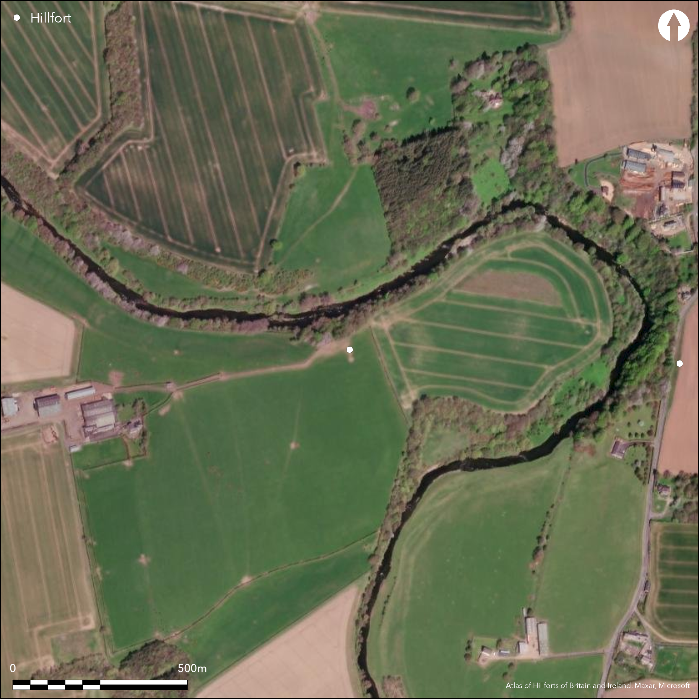
In 1795 the minister of Chirnside, the Rev Walter Anderson, reported in the parish entry in the Statistical Account that an extensive earthwork had stood on the south bank of the Whiteadder Water on the Allanbank estate at 'Chester-knows' (Stat Acct, xiv, 1795, 32-3n). Subsequently located by Alexander Carr (1836, 14) as 'nearly opposite the modern mansion-house of Ninewells', it was placed by James Hewat Craw '750 yards west of Stuartslaw', though the direction must be east (RCAHMS 1915, 85, no.156). And it is here that the OS noted possible traces of two 'ramparts' on vertical aerial photographs enclosing a D-shaped area measuring 170m from E to W by 130m transversely, low down in a meander of the river (NT 8636 5536). Unfortunately Anderson's description, quoted in full below, is cryptic to the modern ear, but is more likely describing the E end of the spur of higher ground extending E from Stuartslaw (NT 8614 5536), where a steep escarpment drops down to the S bank of the Whiteadder Water on the N and the topography forms a much more likely location for a fort. Anderson evidently considered himself an antiquary and provides considerable detail: 'Mounds of earth, in signal elevation, and evidently artificial, appeared to the eye at a considerable distance. On a nearer view, the ground occupied by them, rising towards Whiteadder-bank, facing north, and almost perpendicular, discovered it well chosen for defence, on that quarter; while a double, or triple line of ramparts, secured it upon its declivity, and where it was accessible. They run E. and W., and in a straight direction. There appeared to be vestiges of two other lines, although much sunk, and then partly invaded by the plough, which run from the extremities of the former towards the bank of the water. The whole entrenchment forming a square, but here properly made oblong, on account of its contiguity to the Whiteadder...' (Stat Acct, xiv, 1795, 32-3n). His 'Whiteadder-bank, facing north, and almost perpendicular' is almost certainly the steep escarpment E of Stuartslaw, with a bivallate or trivallate scheme defending the gentler slopes on the E, S and W.
Citizen Science: ✗
Reliability of Data: Unconfirmed
Reliability of Interpretation: Confirmed
X: -247410 Y: 7516997 (EPSG: 3857)
Longitude: -2.2225190866121856 Latitude: 55.79138065686577 (EPSG:4326)
Country: Scotland
Current County or Unitary Authority: Scottish Borders
Historic County: Berwickshire
Current Parish/Community/Council/Townland: Edrom
None
| Extant | ✗ |
| Cropmark | ✗ |
| Likely Destroyed | ✓ |
None
| Woodland | ✗ |
| Commercial Forestry Plantation | ✗ |
| Parkland | ✗ |
| Pasture (Grazing) | ✓ |
| Arable | ✓ |
| Scrub/Bracken | ✗ |
| Bare Outcrop | ✗ |
| Heather/Moorland | ✗ |
| Heath | ✗ |
| Built-up | ✗ |
| Coastal Grassland | ✗ |
| Other | ✗ |
None
| Contour Fort | ✗ |
| Partial Contour Fort | ✗ |
| Promontory Fort | ✗ |
| Hillslope Fort | ✗ |
| Level Terrain Fort | ✓ |
| Marsh Fort | ✗ |
| Multiple Enclosure Fort | ✗ |
| Hilltop | ✗ |
| Coastal Promontory | ✗ |
| Inland Promontory | ✗ |
| Valley Bottom | ✗ |
| Knoll/Hillock/Outcrop | ✗ |
| Ridge | ✗ |
| Cliff/Plateau-edge/Scarp | ✓ |
| Hillslope | ✗ |
| Lowland | ✗ |
| Spur | ✓ |
Dominant Topographic Feature: None
| North | ✗ |
| Northeast | ✗ |
| East | ✗ |
| Southeast | ✗ |
| South | ✗ |
| Southwest | ✗ |
| West | ✗ |
| Northwest | ✗ |
| Level | ✓ |
Altitude: 60.0m
N/A
In the absence of excavation, there are neither stratified artefacts nor radiocarbon dates to provide a chronology for the defences.
Reliability: D - None
| Pre 1200BC | ✗ |
| 1200BC - 800BC | ✗ |
| 800BC - 400BC | ✗ |
| 400BC - AD50 | ✗ |
| AD50 - AD400 | ✗ |
| AD400 - AD 800 | ✗ |
| Post AD800 | ✗ |
| Unknown | ✓ |
| Pre Hillfort: | None |
| Post Hillfort: | Ploughed flat |
The location identified by the OS and the alternative suggested above need further fieldwork to confirm whether either is the site of a fort.
| 1st Identified Written Reference (1765): | Description (Stat Acct, xiv, 1795, 32-3n) |
| Other (1971): | Visited by the OS |
Under plough
None
| None | ✓ |
| Spring | ✗ |
| Stream | ✗ |
| Pool | ✗ |
| Flush | ✗ |
| Well | ✗ |
| Other | ✗ |
None
| No Known Features | ✓ |
| Round Stone Structures | ✗ |
| Rectangular Stone Structures | ✗ |
| Curvilinear Platforms | ✗ |
| Other Roundhouse Evidence | ✗ |
| Pits | ✗ |
| Quarry Hollows | ✗ |
| Other | ✗ |
None
| No Known Excavation | ✓ |
| Pits | ✗ |
| Postholes | ✗ |
| Roundhouses | ✗ |
| Rectangular Structures | ✗ |
| Roads/Tracks | ✗ |
| Quarry Hollows | ✗ |
| Other | ✗ |
| Nothing Found | ✗ |
None
| No Known Geophysics | ✓ |
| Pits | ✗ |
| Roundhouses | ✗ |
| Rectangular Structures | ✗ |
| Roads/Tracks | ✗ |
| Quarry Hollows | ✗ |
| Other | ✗ |
| Nothing Found | ✗ |
None
| No Known Finds | ✓ |
| Pottery | ✗ |
| Metal | ✗ |
| Metalworking | ✗ |
| Human Bones | ✗ |
| Animal Bones | ✗ |
| Lithics | ✗ |
| Environmental | ✗ |
| Other | ✗ |
NO APPARENT FEATURES
| APs Not Checked | ✗ |
| None | ✓ |
| Roundhouses | ✗ |
| Rectangular Structures | ✗ |
| Pits | ✗ |
| Postholes | ✗ |
| Roads/Tracks | ✗ |
| Other | ✗ |
None known
| 0: | Ploughed out |
| 2: | None known |
Guard Chambers: ✗
Chevaux de Frise: ✗
A tri- or bivallate scheme backing onto a steep escarpment; size of the fort is unknown
| Area 1: | Noneha. |
| Total: | Noneha. |
Total Footprint Area: Noneha.
None
| ✗ | None |
| ✗ | None |
| NE Quadrant: | 2 |
| SE Quadrant: | 2 |
| SW Quadrant: | 2 |
| NW Quadrant: | 0 |
| Total: | 2 |
| Partial Univallate | ✗ |
| Univallate | ✗ |
| Partial Bivallate | ✓ |
| Bivallate | ✗ |
| Partial Multivallate | ✗ |
| Multivallate | ✗ |
| Unknown | ✗ |
| Partial Univallate | ✗ |
| Univallate | ✗ |
| Partial Bivallate | ✗ |
| Bivallate | ✗ |
| Partial Multivallate | ✗ |
| Multivallate | ✗ |
None
| None | ✓ |
| Earthen Bank | ✗ |
| Stone Wall | ✗ |
| Rubble | ✗ |
| Wall-walk | ✗ |
| Evidence of Timber | ✗ |
| Vitrification | ✗ |
| Other Burning | ✗ |
| Palisade | ✗ |
| Counter Scarp Bank | ✗ |
| Berm | ✗ |
| Unfinished | ✗ |
| Other | ✗ |
None
| None | ✗ |
| Earthen Bank | ✗ |
| Stone Wall | ✗ |
| Murus Duplex | ✗ |
| Timber-framed | ✗ |
| Timber-laced | ✗ |
| Vitrification | ✗ |
| Other Burning | ✗ |
| Palisade | ✗ |
| Counter Scarp Bank | ✗ |
| Berm | ✗ |
| Unfinished | ✗ |
| No Known Excavation | ✓ |
| Other | ✗ |
| ✗ | None |
| ✗ | None |
Number of Ditches: None
| ✗ | None |
Carr, A A. (1836) A history of Coldingham Priory. Edinburgh
RCAHMS (1915) The Royal Commission on the Ancient and Historical Monuments and Constructions of Scotland. Sixth report and Inventory of Monuments and Constructions in the County of Berwick (Revised Issue). HMSO: Edinburgh
Stat Acct (date) Statistical Account of Scotland: Drawn up from the Communications of the Ministers of the Different Parishes (Sinclair, J ed), 1791-99
Atlas of Hillforts:
Wikidata:
This work is licensed under CC BY-SA 4.0![]()
![]()
![]() and should be cited as:
and should be cited as:
Lock, Gary and Ralston, Ian. 2024. Atlas of Hillforts of Britain and Ireland. Available at: https://hillforts.arch.ox.ac.uk
Document Version 1.1