
LiDAR 1m DTM Hillshade
Satellite Imagery
LiDAR 1m DTM Hillshade
Satellite Imagery
Scroll left/right to view further images.
HER: Scottish Borders 59942 (None)
NMR: NT 86 SW 8 (59942)
SM: 5428
NGR: NT 8312 6200
X: 383129 Y: 662000 (OSGB36)
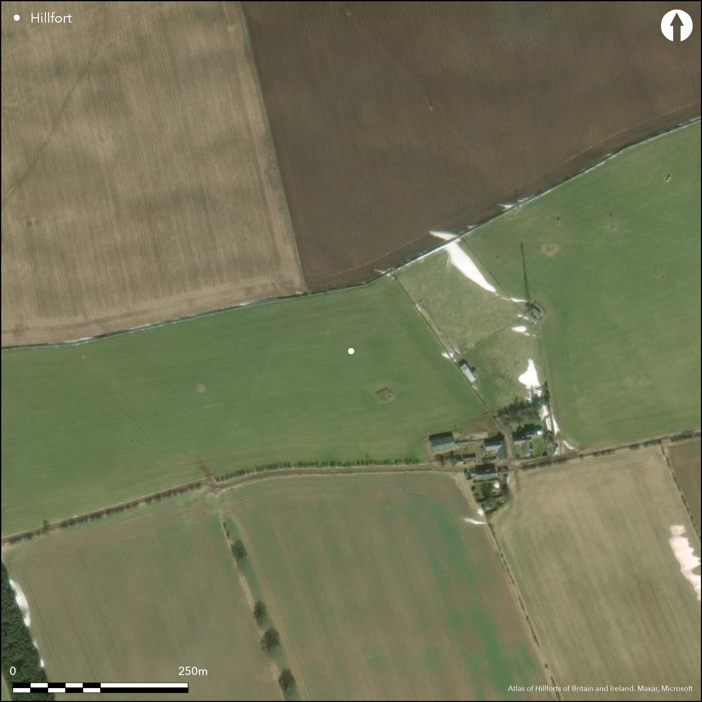
This fort, which occupies a position on the crest of Horsely Hill to the NW of Warlawbank, was intermittently under plough through the 19th century, but sufficient survived for James Hewat Craw to draw up a plan about 1912 showing a near complete circuit of two ramparts flanking a medial ditch, with an outer ditch and counterscarp bank where the ground rose gently towards the summit on the NE quarter. More recently cropmarks of the fort have also been recorded, revealing that the outer ditch was a continuous feature of the defences, while within the interior there are traces of a rather smaller enclosure. The fort is roughly oval on plan, measuring 125m from E to W by 77m transversely (0.77ha) within the inner of the two ditches, which are set about 4m apart around most of the circuit; the inner ditch is some 4m in breadth, and the outer 2.5m, increasing to 3.5m on the NE. Making allowance for the original thickness of the inner rampart, which is generally spread about 7m, the interior probably measured about 115m by a little over 65m (0.6ha). The ditches are pierced by major entrances on the ESE and WSW, while there may also be a narrow causeway across them both on the S; the WSW entrance is a simple gap about 3.5m wide, but the gap on the ESE is in the order of 10m wide, the cropmarks also revealing evidence of heavy traffic, and it is likely that the ramparts formerly returned and united around the terminals of the ditches to either side; all trace of this had been removed before Craw prepared his plan. The evidence of wear here extends into the oval enclosure occupying the eastern half of the fort's interior. It measures internally about 65m from ENE to WSW by 50m transversely, and its ditch, which is little more than 2m in breadth, is apparently broken by causeways on the ENE, SE and WSW respectively; an irregular maculae at the ENE end includes the outline of at least one round-house.
Citizen Science: ✗
Reliability of Data: Confirmed
Reliability of Interpretation: Confirmed
X: -252810 Y: 7528800 (EPSG: 3857)
Longitude: -2.271032053762103 Latitude: 55.85094478821612 (EPSG:4326)
Country: Scotland
Current County or Unitary Authority: Scottish Borders
Historic County: Berwickshire
Current Parish/Community/Council/Townland: Coldingham
Heavily ploughed down
| Extant | ✓ |
| Cropmark | ✓ |
| Likely Destroyed | ✗ |
None
| Woodland | ✗ |
| Commercial Forestry Plantation | ✗ |
| Parkland | ✗ |
| Pasture (Grazing) | ✓ |
| Arable | ✓ |
| Scrub/Bracken | ✗ |
| Bare Outcrop | ✗ |
| Heather/Moorland | ✗ |
| Heath | ✗ |
| Built-up | ✗ |
| Coastal Grassland | ✗ |
| Other | ✗ |
None
| Contour Fort | ✓ |
| Partial Contour Fort | ✗ |
| Promontory Fort | ✗ |
| Hillslope Fort | ✗ |
| Level Terrain Fort | ✗ |
| Marsh Fort | ✗ |
| Multiple Enclosure Fort | ✗ |
| Hilltop | ✓ |
| Coastal Promontory | ✗ |
| Inland Promontory | ✗ |
| Valley Bottom | ✗ |
| Knoll/Hillock/Outcrop | ✗ |
| Ridge | ✗ |
| Cliff/Plateau-edge/Scarp | ✗ |
| Hillslope | ✗ |
| Lowland | ✗ |
| Spur | ✗ |
Dominant Topographic Feature: None
| North | ✗ |
| Northeast | ✗ |
| East | ✗ |
| Southeast | ✗ |
| South | ✗ |
| Southwest | ✗ |
| West | ✗ |
| Northwest | ✗ |
| Level | ✓ |
Altitude: 260.0m
N/A
In the absence of excavation, there are neither stratified artefacts nor radiocarbon dates to provide a chronology for the defences.
Reliability: D - None
| Pre 1200BC | ✗ |
| 1200BC - 800BC | ✗ |
| 800BC - 400BC | ✗ |
| 400BC - AD50 | ✗ |
| AD50 - AD400 | ✗ |
| AD400 - AD 800 | ✗ |
| Post AD800 | ✗ |
| Unknown | ✓ |
| Pre Hillfort: | None |
| Post Hillfort: | Ploughed down and a water cistern let into the SE flank |
Photographed by John Dewar in 1971 (held by RCAHMS), and by RCAHMS Aerial Survey Programme in 1978, 1981, 1988, 1990, 1992, 1993, 1994, 1999 and 2000
| 1st Identified Map Depiction (1771): | Concentric ring on a hill symbol on Andrew and Mostyn Armstrong's Map of the County of Berwick (1771) |
| Other (1856): | Annotated Camp on the 1st edition OS 25-inch map (Berwick 1860, sheet 11.1) |
| Other (1895): | Description by Francis Lynn (1895, 374) |
| Other (1895): | Description by David Christison with paced measurements by H H Craw (1895, 165) |
| Other (1908): | Description (RCAHMS 1909, 18, no.7) |
| Earthwork Survey (1912): | Plan by James Hewat Craw and description (RCAHMS 1915, 52, no.90, fig 52; RCAHMS BWD 20/1; BWD 20/1/1 & DP225395, DP228313) |
| Other (1954): | Visited by the OS |
| Other (1966): | Surveyed at 1:2500 by the OS |
| Other (1979): | Visited by RCAHMS |
| Other (1992): | Scheduled |
| Other (2009): | Re-Scheduled |
A large oval enclosure containing an irregular maculae that includes the outline of at least one round-house
None
| None | ✓ |
| Spring | ✗ |
| Stream | ✗ |
| Pool | ✗ |
| Flush | ✗ |
| Well | ✗ |
| Other | ✗ |
None
| No Known Features | ✓ |
| Round Stone Structures | ✗ |
| Rectangular Stone Structures | ✗ |
| Curvilinear Platforms | ✗ |
| Other Roundhouse Evidence | ✗ |
| Pits | ✗ |
| Quarry Hollows | ✗ |
| Other | ✗ |
None
| No Known Excavation | ✓ |
| Pits | ✗ |
| Postholes | ✗ |
| Roundhouses | ✗ |
| Rectangular Structures | ✗ |
| Roads/Tracks | ✗ |
| Quarry Hollows | ✗ |
| Other | ✗ |
| Nothing Found | ✗ |
None
| No Known Geophysics | ✓ |
| Pits | ✗ |
| Roundhouses | ✗ |
| Rectangular Structures | ✗ |
| Roads/Tracks | ✗ |
| Quarry Hollows | ✗ |
| Other | ✗ |
| Nothing Found | ✗ |
None
| No Known Finds | ✓ |
| Pottery | ✗ |
| Metal | ✗ |
| Metalworking | ✗ |
| Human Bones | ✗ |
| Animal Bones | ✗ |
| Lithics | ✗ |
| Environmental | ✗ |
| Other | ✗ |
At least one, possibly overlapping a second
| APs Not Checked | ✗ |
| None | ✗ |
| Roundhouses | ✓ |
| Rectangular Structures | ✗ |
| Pits | ✗ |
| Postholes | ✗ |
| Roads/Tracks | ✗ |
| Other | ✗ |
See main summary
| 3: | The whole circuit is ploughed down |
| 2: | None |
Guard Chambers: ✗
Chevaux de Frise: ✗
| 1. Passage-way/Corridor (South east): | The width of the gap suggests the ramparts returned and united around the terminals of the ditches |
| 2. Simple Gap (South): | A narrow causeway across the ditches |
| 3. Simple Gap (West): | None |
Twin ramparts and ditches, and possibly originally with a counterscarp bank around the greater part of the circuit. A notable feature of the inner ditch on the S is its irregularity, varying in breadth between 3m and 5m, the junctions between with the two narrower segment suggesting that broader pits had been linked up into a narrower ditch; either as a result of the process of construction or as an episode of recutting.
| Area 1: | 0.6ha. |
| Total: | 0.6ha. |
Total Footprint Area: 1.3ha.
None
| ✗ | None |
| ✓ | Excludes the internal enclosure |
| NE Quadrant: | 2 |
| SE Quadrant: | 2 |
| SW Quadrant: | 2 |
| NW Quadrant: | 2 |
| Total: | 2 |
| Partial Univallate | ✗ |
| Univallate | ✗ |
| Partial Bivallate | ✗ |
| Bivallate | ✓ |
| Partial Multivallate | ✗ |
| Multivallate | ✗ |
| Unknown | ✗ |
| Partial Univallate | ✗ |
| Univallate | ✗ |
| Partial Bivallate | ✗ |
| Bivallate | ✗ |
| Partial Multivallate | ✗ |
| Multivallate | ✗ |
None
| None | ✗ |
| Earthen Bank | ✓ |
| Stone Wall | ✗ |
| Rubble | ✗ |
| Wall-walk | ✗ |
| Evidence of Timber | ✗ |
| Vitrification | ✗ |
| Other Burning | ✗ |
| Palisade | ✗ |
| Counter Scarp Bank | ✓ |
| Berm | ✗ |
| Unfinished | ✗ |
| Other | ✗ |
None
| None | ✗ |
| Earthen Bank | ✗ |
| Stone Wall | ✗ |
| Murus Duplex | ✗ |
| Timber-framed | ✗ |
| Timber-laced | ✗ |
| Vitrification | ✗ |
| Other Burning | ✗ |
| Palisade | ✗ |
| Counter Scarp Bank | ✗ |
| Berm | ✗ |
| Unfinished | ✗ |
| No Known Excavation | ✓ |
| Other | ✗ |
| ✓ | Possible evidence that the inner ditch was dug in a series of short segments on the S side |
| ✓ | None |
Number of Ditches: 2
| ✗ | None |
Christison, D (1895) 'The forts of Selkirk, the Gala Water, the Southern slopes of the Lammermoors, and the north of Roxburgh'. Proc Soc Antiq Scot 29 (1894-50), 108-79
Lynn, F (1897) 'Bunkle Edge forts'. Hist Berwickshire Natur Club 15 (1894-5), 365-76
RCAHMS (1909) The Royal Commission on the Ancient and Historical Monuments and Constructions of Scotland. First report and Inventory of Monuments and Constructions in the County of Berwick. HMSO: Edinburgh.
RCAHMS (1915) The Royal Commission on the Ancient and Historical Monuments and Constructions of Scotland. Sixth report and Inventory of Monuments and Constructions in the County of Berwick (Revised Issue). HMSO: Edinburgh
Atlas of Hillforts:
Wikidata:
This work is licensed under CC BY-SA 4.0![]()
![]()
![]() and should be cited as:
and should be cited as:
Lock, Gary and Ralston, Ian. 2024. Atlas of Hillforts of Britain and Ireland. Available at: https://hillforts.arch.ox.ac.uk
Document Version 1.1