Satellite Imagery
Satellite Imagery
HER: Scottish Borders 59962 (None)
NMR: NT 87 SW 9 (59962)
SM: None
NGR: NT 8111 7088
X: 381110 Y: 670880 (OSGB36)
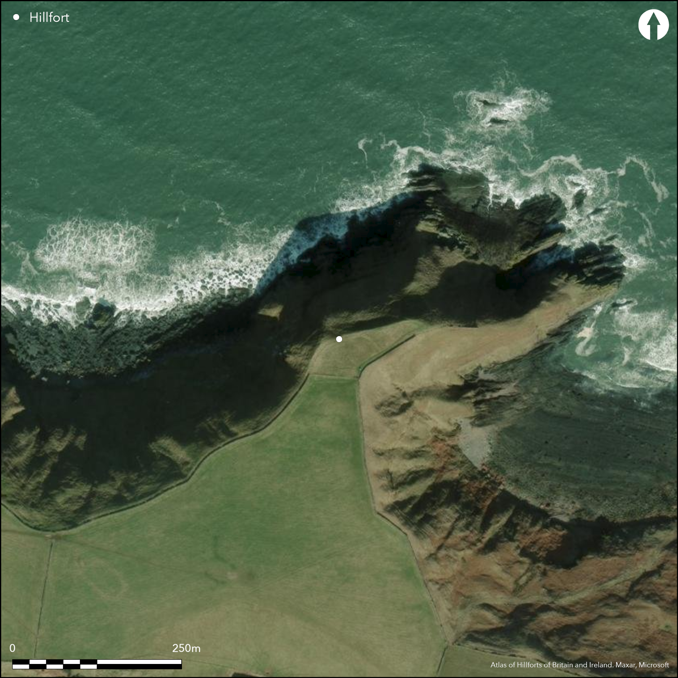
The high promontory that terminates at its seaward end in Siccar Point is reported to be the site of a promontory fort (Kinghorn 1935, 157-8), though little trace of the rampart recorded crossing the neck on the SSW remains visible, and in 1979 RCAHMS investigators considered that the bank along the western margin was more likely to be a field enclosure of relatively recent date, a view not shared by OS surveyors in 1954 and 1965, nor by a subsequent Coastal Assessment Survey by GUARD in 1996 (James 2003, 121). As reported by Robert Kinghorn, the rampart on the SSW was under cultivation and had been reduced to a broad earthen mound, which outside the dike on the NW turned along the edge of the promontory for a distance of 90m, where it stood up to 1.3m high; no trace of a ditch has been observed accompanying this rampart, but a gap at the E margin of the promontory provides a possible entrance. As defined, the interior measures about 150m along the crest of the promontory by a maximum of 80m transversely (0.6ha) at the landward end, extending in a gentle arc north-eastwards to terminate in a point at the seaward end. While doubts have been expressed about the authenticity of the defences, there can be no doubt that this promontory has been used, and along the leading edge of a terrace on the N flank of the interior and on the slope below Kinghorn found midden deposits some 0.6m deep. Finds from the midden included: a sherd of coarse pottery; an Iron Age blue glass bead; a piece of iron slag; periwinkle and limpet shells, and cattle and sheep bones, some of which had been split.
Citizen Science: ✗
Reliability of Data: Unconfirmed
Reliability of Interpretation: Unconfirmed
X: -256469 Y: 7544623 (EPSG: 3857)
Longitude: -2.3039026703443977 Latitude: 55.93065544085688 (EPSG:4326)
Country: Scotland
Current County or Unitary Authority: Scottish Borders
Historic County: Berwickshire
Current Parish/Community/Council/Townland: Cockburnspath
None
| Extant | ✓ |
| Cropmark | ✗ |
| Likely Destroyed | ✓ |
None
| Woodland | ✗ |
| Commercial Forestry Plantation | ✗ |
| Parkland | ✗ |
| Pasture (Grazing) | ✓ |
| Arable | ✗ |
| Scrub/Bracken | ✗ |
| Bare Outcrop | ✗ |
| Heather/Moorland | ✗ |
| Heath | ✗ |
| Built-up | ✗ |
| Coastal Grassland | ✗ |
| Other | ✗ |
None
| Contour Fort | ✗ |
| Partial Contour Fort | ✗ |
| Promontory Fort | ✓ |
| Hillslope Fort | ✗ |
| Level Terrain Fort | ✗ |
| Marsh Fort | ✗ |
| Multiple Enclosure Fort | ✗ |
| Hilltop | ✗ |
| Coastal Promontory | ✓ |
| Inland Promontory | ✗ |
| Valley Bottom | ✗ |
| Knoll/Hillock/Outcrop | ✗ |
| Ridge | ✗ |
| Cliff/Plateau-edge/Scarp | ✗ |
| Hillslope | ✗ |
| Lowland | ✗ |
| Spur | ✗ |
Dominant Topographic Feature: None
| North | ✗ |
| Northeast | ✗ |
| East | ✗ |
| Southeast | ✗ |
| South | ✗ |
| Southwest | ✗ |
| West | ✗ |
| Northwest | ✗ |
| Level | ✓ |
Altitude: 76.0m
N/A
The context of the blue glass bead found here is unknown, other than being probably derived from midden deposits, and the date of any defences is unknown.
Reliability: D - None
| Pre 1200BC | ✗ |
| 1200BC - 800BC | ✗ |
| 800BC - 400BC | ✗ |
| 400BC - AD50 | ✗ |
| AD50 - AD400 | ✗ |
| AD400 - AD 800 | ✗ |
| Post AD800 | ✗ |
| Unknown | ✓ |
| Pre Hillfort: | None |
| Post Hillfort: | Ploughed down |
| Artefactual: | Iron Age blue glass bead |
None
| Earthwork Survey (1933): | Plan and description by Robert Kinghorn (1935, 157-8, fig 1) |
| Other (1954): | Visited by the OS |
| Other (1965): | Surveyed at 1:2500 by the OS |
| Other (1979): | Visited by RCAHMS |
| Other (1996): | Coastal Assessment Survey for Historic Scotland by GUARD (James 2003, 121) |
Featureless
None
| None | ✓ |
| Spring | ✗ |
| Stream | ✗ |
| Pool | ✗ |
| Flush | ✗ |
| Well | ✗ |
| Other | ✗ |
None
| No Known Features | ✓ |
| Round Stone Structures | ✗ |
| Rectangular Stone Structures | ✗ |
| Curvilinear Platforms | ✗ |
| Other Roundhouse Evidence | ✗ |
| Pits | ✗ |
| Quarry Hollows | ✗ |
| Other | ✗ |
None
| No Known Excavation | ✓ |
| Pits | ✗ |
| Postholes | ✗ |
| Roundhouses | ✗ |
| Rectangular Structures | ✗ |
| Roads/Tracks | ✗ |
| Quarry Hollows | ✗ |
| Other | ✗ |
| Nothing Found | ✗ |
None
| No Known Geophysics | ✓ |
| Pits | ✗ |
| Roundhouses | ✗ |
| Rectangular Structures | ✗ |
| Roads/Tracks | ✗ |
| Quarry Hollows | ✗ |
| Other | ✗ |
| Nothing Found | ✗ |
Finds from midden included: a sherd of coarse pottery; a blue glass bead of Iron Age date (NMAS FJ 126); a piece of iron slag; periwinkle and limpet shells, and cattle and sheep bones, some of which had been split
| No Known Finds | ✗ |
| Pottery | ✓ |
| Metal | ✗ |
| Metalworking | ✗ |
| Human Bones | ✗ |
| Animal Bones | ✓ |
| Lithics | ✗ |
| Environmental | ✗ |
| Other | ✓ |
NO APPARENT FEATURES
| APs Not Checked | ✗ |
| None | ✓ |
| Roundhouses | ✗ |
| Rectangular Structures | ✗ |
| Pits | ✗ |
| Postholes | ✗ |
| Roads/Tracks | ✗ |
| Other | ✗ |
See main summary
| 1: | Now ploughed down |
| 2: | None |
Guard Chambers: ✗
Chevaux de Frise: ✗
| 1. Simple Gap (South): | A gap between the terminal of the putative rampart and the E margin of the promontory |
Possibly a single rampart across the neck of the promontory
| Area 1: | 0.6ha. |
| Total: | 0.6ha. |
Total Footprint Area: Noneha.
None
| ✗ | None |
| ✗ | None |
| NE Quadrant: | 0 |
| SE Quadrant: | 0 |
| SW Quadrant: | 1 |
| NW Quadrant: | 1 |
| Total: | 1 |
| Partial Univallate | ✓ |
| Univallate | ✗ |
| Partial Bivallate | ✗ |
| Bivallate | ✗ |
| Partial Multivallate | ✗ |
| Multivallate | ✗ |
| Unknown | ✗ |
| Partial Univallate | ✗ |
| Univallate | ✗ |
| Partial Bivallate | ✗ |
| Bivallate | ✗ |
| Partial Multivallate | ✗ |
| Multivallate | ✗ |
None
| None | ✗ |
| Earthen Bank | ✓ |
| Stone Wall | ✗ |
| Rubble | ✗ |
| Wall-walk | ✗ |
| Evidence of Timber | ✗ |
| Vitrification | ✗ |
| Other Burning | ✗ |
| Palisade | ✗ |
| Counter Scarp Bank | ✗ |
| Berm | ✗ |
| Unfinished | ✗ |
| Other | ✗ |
None
| None | ✗ |
| Earthen Bank | ✗ |
| Stone Wall | ✗ |
| Murus Duplex | ✗ |
| Timber-framed | ✗ |
| Timber-laced | ✗ |
| Vitrification | ✗ |
| Other Burning | ✗ |
| Palisade | ✗ |
| Counter Scarp Bank | ✗ |
| Berm | ✗ |
| Unfinished | ✗ |
| No Known Excavation | ✓ |
| Other | ✗ |
| ✗ | None |
| ✗ | None recorded |
Number of Ditches: None
| ✗ | None |
James, H F (2003) 'Assessment survey: the Firth of Forth (Dunbar to the border of Fife)'. In Dawson, T, Coastal archaeology and erosion in Scotland. Edinburgh.
Kinghorn, R (1935) 'Unrecorded Berwickshire antiquities, being the Chalmers-Jervise Prize essay for 1933'. Proc Soc Antiq Scot 69 (1934-5), 157-67
Atlas of Hillforts:
Wikidata:
This work is licensed under CC BY-SA 4.0![]()
![]()
![]() and should be cited as:
and should be cited as:
Lock, Gary and Ralston, Ian. 2024. Atlas of Hillforts of Britain and Ireland. Available at: https://hillforts.arch.ox.ac.uk
Document Version 1.1