
LiDAR 1m DTM Hillshade
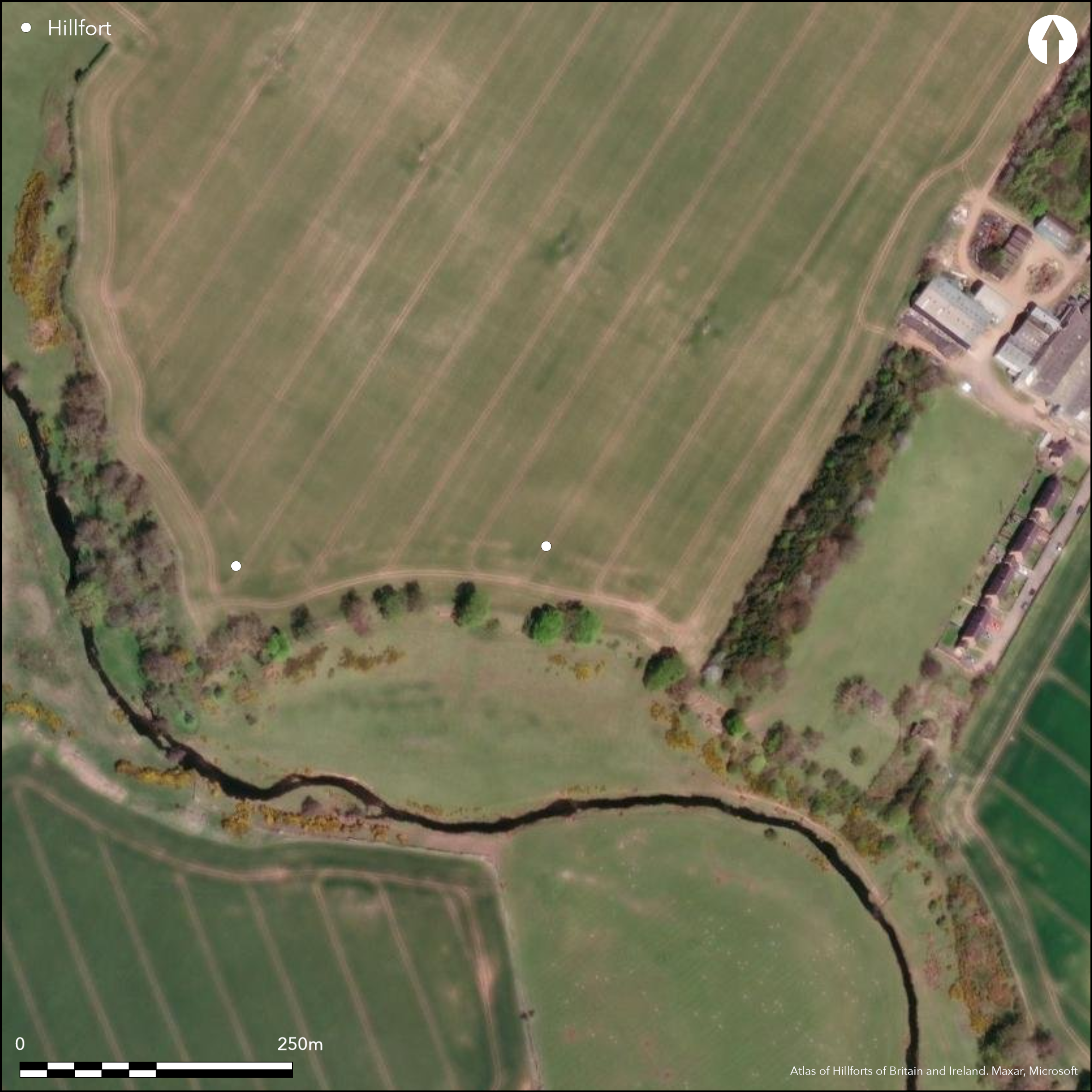
Satellite Imagery
LiDAR 1m DTM Hillshade
Satellite Imagery
Scroll left/right to view further images.
HER: Scottish Borders 60262 (None)
NMR: NT 96 SW 7 (60262)
SM: 12512
NGR: NT 9118 6088
X: 391180 Y: 660880 (OSGB36)
This fort, the eastern of two (See Atlas No.4133), is situated on gently shelving ground dropping into edge of the steep escarpment above the N bank of a meander of the Eye Water WSW of Aytonlaw. First recorded by James Hewat Craw about 1920 as a roughly circular depression in the surface of the field some 65m in diameter, both the scooped interior and the inner ditch were still visible on the ground when visited by RCAHMS investigators in 1979, but cropmarks reveal that the two ditches of the defences describe an open ended U-shape on plan, backing onto the edge of the escarpment on the SSW. The scar of the inner rampart encloses an area measuring about 60m from ESE to WNW parallel to the escarpment by 55m transversely (0.3ha). The two ditches are set between 3m and 4m apart, the inner being about 7m broad and the outer up to 5m, and there is a faint scar of a counterscarp rampart outside the outer on the NW. The entrance is on the ESE, where a clearly defined causeway crosses both ditches just short of the edge of the escarpment. A large irregular macula occupies most of the interior, reflecting the accumulation of deeper sediments in the scoop, but several angular shapes around its fringes suggest the presence of rectangular buildings, and it may even have been reoccupied as a farmstead in the post-medieval period.
Citizen Science: ✗
Reliability of Data: Confirmed
Reliability of Interpretation: Confirmed
X: -238491 Y: 7526847 (EPSG: 3857)
Longitude: -2.142402355602678 Latitude: 55.84109752790099 (EPSG:4326)
Country: Scotland
Current County or Unitary Authority: Scottish Borders
Historic County: Berwickshire
Current Parish/Community/Council/Townland: Ayton
The scoop of the interior and traces of the inner ditch were still visible in 1979
| Extant | ✓ |
| Cropmark | ✓ |
| Likely Destroyed | ✗ |
None
| Woodland | ✗ |
| Commercial Forestry Plantation | ✗ |
| Parkland | ✗ |
| Pasture (Grazing) | ✗ |
| Arable | ✓ |
| Scrub/Bracken | ✗ |
| Bare Outcrop | ✗ |
| Heather/Moorland | ✗ |
| Heath | ✗ |
| Built-up | ✗ |
| Coastal Grassland | ✗ |
| Other | ✗ |
None
| Contour Fort | ✗ |
| Partial Contour Fort | ✗ |
| Promontory Fort | ✗ |
| Hillslope Fort | ✓ |
| Level Terrain Fort | ✗ |
| Marsh Fort | ✗ |
| Multiple Enclosure Fort | ✗ |
| Hilltop | ✗ |
| Coastal Promontory | ✗ |
| Inland Promontory | ✗ |
| Valley Bottom | ✗ |
| Knoll/Hillock/Outcrop | ✗ |
| Ridge | ✗ |
| Cliff/Plateau-edge/Scarp | ✓ |
| Hillslope | ✓ |
| Lowland | ✗ |
| Spur | ✗ |
Dominant Topographic Feature: None
| North | ✗ |
| Northeast | ✗ |
| East | ✗ |
| Southeast | ✗ |
| South | ✓ |
| Southwest | ✗ |
| West | ✗ |
| Northwest | ✗ |
| Level | ✗ |
Altitude: 60.0m
N/A
In the absence of excavation, there are neither stratified artefacts nor radiocarbon dates to provide a chronology for the defences.
Reliability: D - None
| Pre 1200BC | ✗ |
| 1200BC - 800BC | ✗ |
| 800BC - 400BC | ✗ |
| 400BC - AD50 | ✗ |
| AD50 - AD400 | ✗ |
| AD400 - AD 800 | ✗ |
| Post AD800 | ✗ |
| Unknown | ✓ |
| Pre Hillfort: | None |
| Post Hillfort: | Ploughed down |
Photographed by CUCAP in 1948, 1959 and 1970 (St Joseph 1967, 148), by Dennis Harding in 1978, and by RCAHMS Aerial Survey Programme in 1976, 1977, 1978, 1980, 1981, 1982, 1983, 1987, 1991, 1994, 1996 and 1999
| 1st Identified Map Depiction (1771): | Concentric ring symbol on Andrew and Mostyn Armstrong's Map of the County of Berwick (1771) |
| Earthwork Survey (1920): | Sketch-plan and description by James Hewat Craw (1921, 241-2, fig 2) |
| Other (1948): | First photographed by CUCAP |
| Other (1954): | Visited by the OS |
| Other (1966): | Visited by the OS |
| Other (1979): | Visited by RCAHMS |
| Other (2009): | Scheduled |
Several irregular maculae in a scooped interior
None
| None | ✓ |
| Spring | ✗ |
| Stream | ✗ |
| Pool | ✗ |
| Flush | ✗ |
| Well | ✗ |
| Other | ✗ |
Shallow scoop marks the site of the interior
| No Known Features | ✗ |
| Round Stone Structures | ✗ |
| Rectangular Stone Structures | ✗ |
| Curvilinear Platforms | ✗ |
| Other Roundhouse Evidence | ✗ |
| Pits | ✗ |
| Quarry Hollows | ✗ |
| Other | ✓ |
None
| No Known Excavation | ✓ |
| Pits | ✗ |
| Postholes | ✗ |
| Roundhouses | ✗ |
| Rectangular Structures | ✗ |
| Roads/Tracks | ✗ |
| Quarry Hollows | ✗ |
| Other | ✗ |
| Nothing Found | ✗ |
None
| No Known Geophysics | ✓ |
| Pits | ✗ |
| Roundhouses | ✗ |
| Rectangular Structures | ✗ |
| Roads/Tracks | ✗ |
| Quarry Hollows | ✗ |
| Other | ✗ |
| Nothing Found | ✗ |
None
| No Known Finds | ✓ |
| Pottery | ✗ |
| Metal | ✗ |
| Metalworking | ✗ |
| Human Bones | ✗ |
| Animal Bones | ✗ |
| Lithics | ✗ |
| Environmental | ✗ |
| Other | ✗ |
Several irregular maculae, at least one of which appears more angular than round
| APs Not Checked | ✗ |
| None | ✗ |
| Roundhouses | ✗ |
| Rectangular Structures | ✗ |
| Pits | ✗ |
| Postholes | ✗ |
| Roads/Tracks | ✗ |
| Other | ✓ |
See main summary
| 1: | Whole circuit ploughed down |
| 2: | None |
Guard Chambers: ✗
Chevaux de Frise: ✗
| 1. Simple Gap (South east): | Through both ditches |
Twin ramparts and ditches forming a U-shape backing onto an escarpment, and with the scar of a counterscarp bank in one sector
| Area 1: | 0.3ha. |
| Total: | 0.3ha. |
Total Footprint Area: Noneha.
None
| ✗ | None |
| ✗ | None |
| NE Quadrant: | 2 |
| SE Quadrant: | 2 |
| SW Quadrant: | 2 |
| NW Quadrant: | 2 |
| Total: | 2 |
| Partial Univallate | ✗ |
| Univallate | ✗ |
| Partial Bivallate | ✗ |
| Bivallate | ✓ |
| Partial Multivallate | ✗ |
| Multivallate | ✗ |
| Unknown | ✗ |
| Partial Univallate | ✗ |
| Univallate | ✗ |
| Partial Bivallate | ✗ |
| Bivallate | ✗ |
| Partial Multivallate | ✗ |
| Multivallate | ✗ |
Scar of a counterscarp bank visible on aerial photographs
| None | ✓ |
| Earthen Bank | ✗ |
| Stone Wall | ✗ |
| Rubble | ✗ |
| Wall-walk | ✗ |
| Evidence of Timber | ✗ |
| Vitrification | ✗ |
| Other Burning | ✗ |
| Palisade | ✗ |
| Counter Scarp Bank | ✓ |
| Berm | ✗ |
| Unfinished | ✗ |
| Other | ✗ |
None
| None | ✗ |
| Earthen Bank | ✗ |
| Stone Wall | ✗ |
| Murus Duplex | ✗ |
| Timber-framed | ✗ |
| Timber-laced | ✗ |
| Vitrification | ✗ |
| Other Burning | ✗ |
| Palisade | ✗ |
| Counter Scarp Bank | ✗ |
| Berm | ✗ |
| Unfinished | ✗ |
| No Known Excavation | ✓ |
| Other | ✗ |
| ✗ | None |
| ✓ | None |
Number of Ditches: 2
| ✗ | None |
Craw, J H (1921) 'Notes on Berwickshire Forts, with a description of those recently discovered'. Proc Soc Antiq Scot 55 (1920-1), 231-55
St Joseph, J K (1967) Air reconnaissance: recent results, 10'. Antiquity 41 (1967), 148-9
Atlas of Hillforts:
Wikidata:
This work is licensed under CC BY-SA 4.0![]()
![]()
![]() and should be cited as:
and should be cited as:
Lock, Gary and Ralston, Ian. 2024. Atlas of Hillforts of Britain and Ireland. Available at: https://hillforts.arch.ox.ac.uk
Document Version 1.1