LiDAR 1m DTM Hillshade
Satellite Imagery
LiDAR 1m DTM Hillshade
Satellite Imagery
Scroll left/right to view further images.
HER: Scottish Borders 60150 (None)
NMR: NT 96 NW 17 (60150)
SM: 2975
NGR: NT 9164 6871
X: 391600 Y: 668700 (OSGB36)
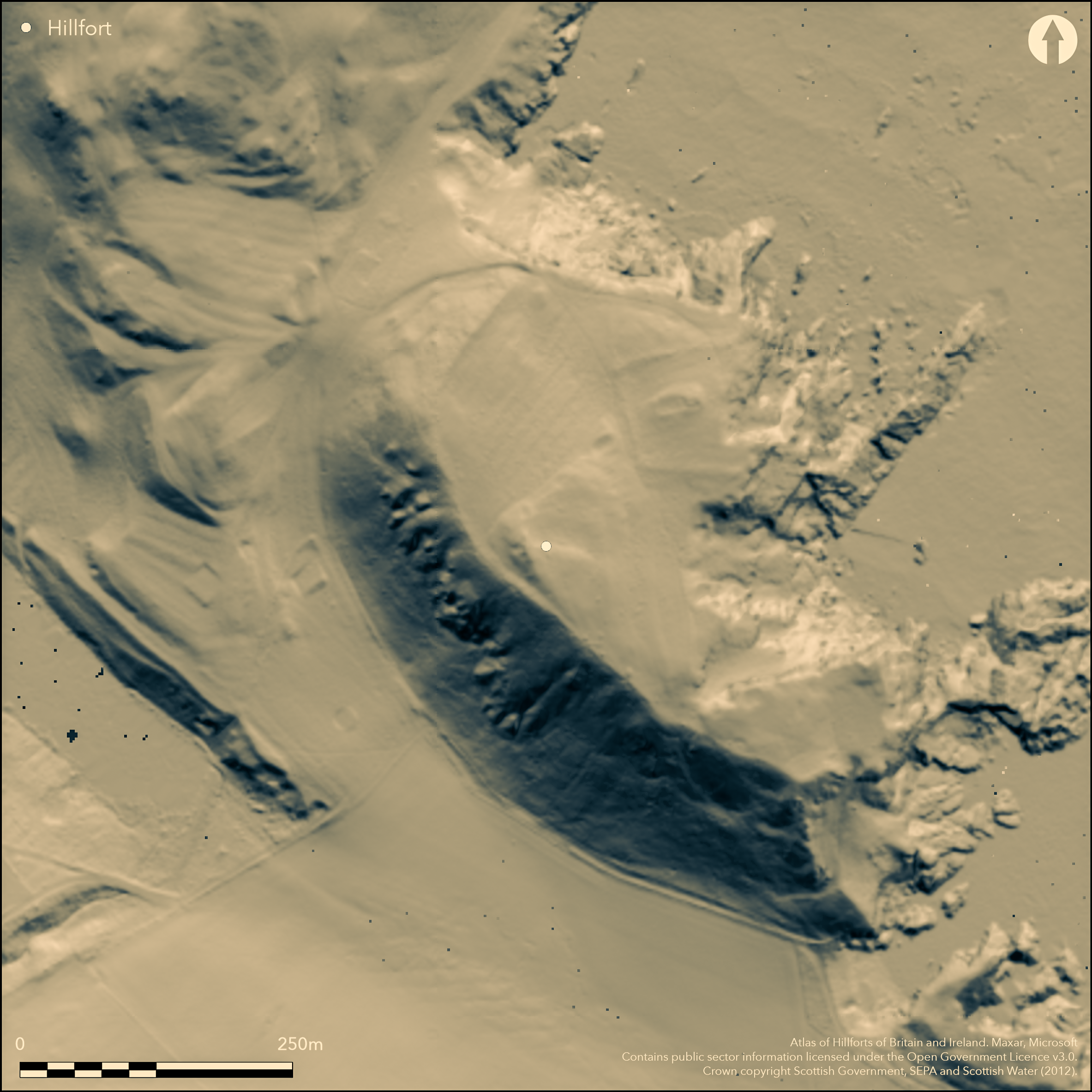
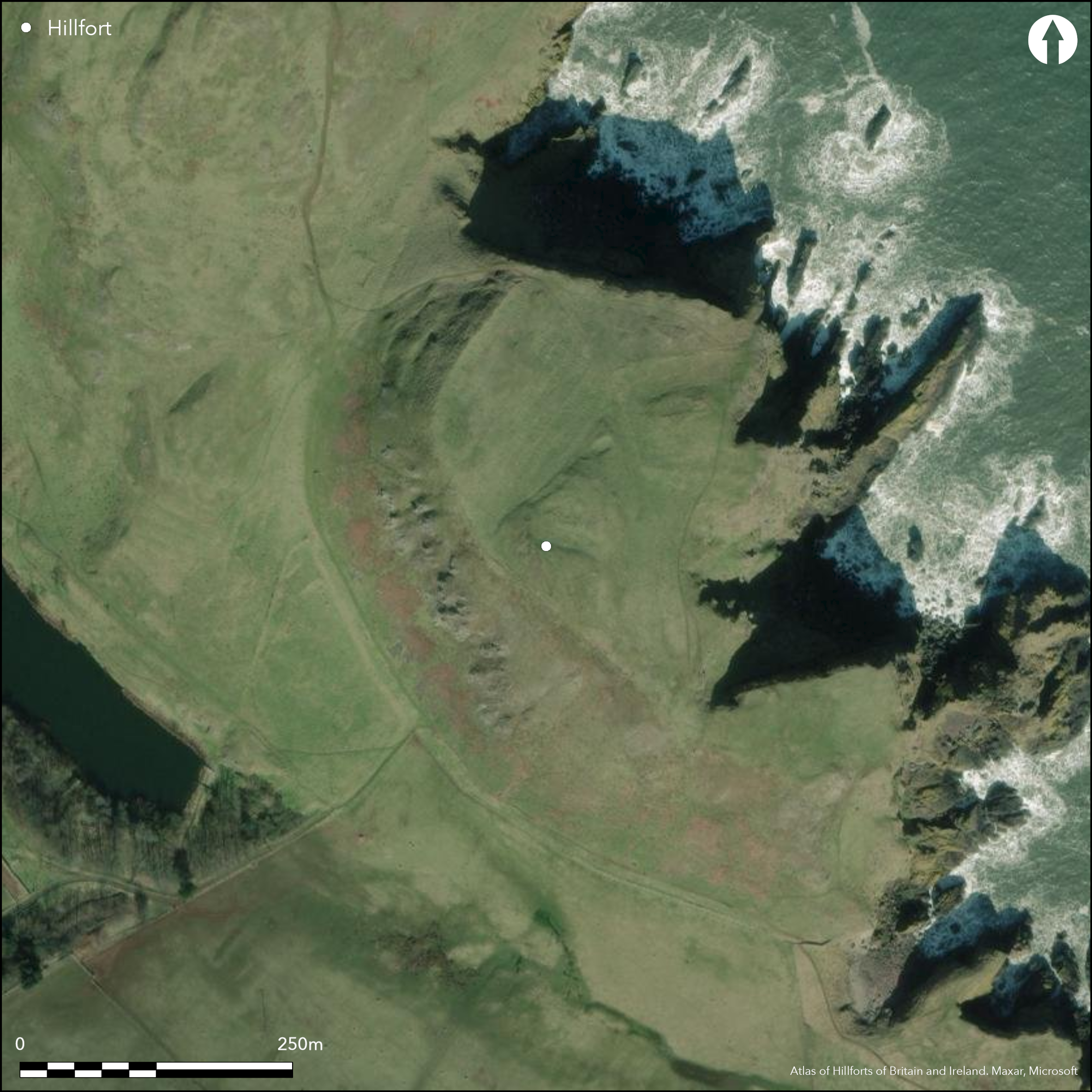
This fort occupies the summit area of Kirk Hill, which forms the southern end of the spectacular coastal cliffs of St Abb's Head. The name of the hill alludes to the site of St Abb's Kirk, with a traditional association to St Aebbe, the abbess of a monastery named in early medieval documentary sources as Colodaesburg, a name which itself implies a fortified place (Alcock 1981a, 162-5; Alcock et al 1986); the monastery was accidently burnt down and subsequently deserted, probably not long after AD 681. Though there may still be some room for debate as to the precise location of this monastery, there can be no doubt that the Kirk Hill has been enclosed and fortified, and the remains of a rampart, surmounted by what is probably a post-medieval dyke can be traced in a broad arc around the lip of the summit, with its terminals resting on entrances where tracks mount the slope at the cliff-edge on the NW and SE respectively. The interior measures about 300m from NW to SE by 160m transversely (0.28ha), effectively embracing two promontories, the southern of which is almost detached by a deep running in from the seaward side. A trench excavated across the rampart on the NW revealed a complex sequence in which the inner of two palisade trenches had been cut through a previously cultivated soil, and superseded by a rampart of turf an clay, with its leading edge founded on a mass of pitched, dressed sandstone blocks; this rampart was subsequently thickened and revetted with a drystone face, giving it an overall thickness of some 8m and an eroded height of 3m (Alcok 1986, 268-73). There is no stratigraphic evidence to demonstrate the relationship between the two palisades, but the inner line had been burnt, and radiocarbon dates from its destruction provide a terminus post quem date for the construction of the rampart in the 6th-9th centuries AD. Apart from the church lying within its enclosure on the large northern portion of the interior, the footings of several rectangular buildings are visible, one on a large platform cut into the E side of the knoll forming the true summit, while others can be inferred from both parchmarks on aerial photographs and anomalies on a geophysical survey carried out in 2011, and mortar has also been recovered from molehills within the interior; the presence of timber buildings can also be inferred from post-holes and rock-cut trenches, apparently belonging to a rectangular structure lying parallel to the rampart, which were uncovered at the inner end of the excavation trench (Alcock 1986, 272). Survey has also revealed four or five shallow scooped platforms on the smaller southern portion of the interior. A small number of items of Roman date found on the Kirk Hill hint at a Roman Iron Age occupation, the only one that is stratified coming from the top of the cultivated soil beneath the rampart.
Citizen Science: ✗
Reliability of Data: Confirmed
Reliability of Interpretation: Confirmed
X: -237772 Y: 7540792 (EPSG: 3857)
Longitude: -2.13594094803717 Latitude: 55.91136796620677 (EPSG:4326)
Country: Scotland
Current County or Unitary Authority: Scottish Borders
Historic County: Berwickshire
Current Parish/Community/Council/Townland: Coldingham
None
| Extant | ✓ |
| Cropmark | ✗ |
| Likely Destroyed | ✗ |
Parts of the interior were cultivated in rigs in the late 18th century
| Woodland | ✗ |
| Commercial Forestry Plantation | ✗ |
| Parkland | ✗ |
| Pasture (Grazing) | ✓ |
| Arable | ✗ |
| Scrub/Bracken | ✗ |
| Bare Outcrop | ✗ |
| Heather/Moorland | ✓ |
| Heath | ✗ |
| Built-up | ✗ |
| Coastal Grassland | ✗ |
| Other | ✗ |
None
| Contour Fort | ✓ |
| Partial Contour Fort | ✗ |
| Promontory Fort | ✓ |
| Hillslope Fort | ✗ |
| Level Terrain Fort | ✗ |
| Marsh Fort | ✗ |
| Multiple Enclosure Fort | ✗ |
| Hilltop | ✓ |
| Coastal Promontory | ✓ |
| Inland Promontory | ✗ |
| Valley Bottom | ✗ |
| Knoll/Hillock/Outcrop | ✗ |
| Ridge | ✗ |
| Cliff/Plateau-edge/Scarp | ✗ |
| Hillslope | ✗ |
| Lowland | ✗ |
| Spur | ✗ |
Dominant Topographic Feature: None
| North | ✗ |
| Northeast | ✗ |
| East | ✗ |
| Southeast | ✗ |
| South | ✗ |
| Southwest | ✗ |
| West | ✗ |
| Northwest | ✗ |
| Level | ✓ |
Altitude: 79.0m
N/A
The presence of Roman Iron Age items on the hill hint at an earlier occupation, but a reasonably secure terminus post quem for the construction of the rampart in the 6-9th centuries AD is provided by three radiocarbon dates from the burnt palisade
Reliability: B - Medium
| Pre 1200BC | ✗ |
| 1200BC - 800BC | ✗ |
| 800BC - 400BC | ✗ |
| 400BC - AD50 | ✗ |
| AD50 - AD400 | ✗ |
| AD400 - AD 800 | ✓ |
| Post AD800 | ✗ |
| Unknown | ✗ |
| Pre Hillfort: | None |
| Post Hillfort: | None |
| C14: | Three radiocarbon dates |
The church is shown on the 1st edition OS 25-inch map (Berwick 1858, sheet 5.4), which also depicts the escarpment defining the line of the rampart, and the church was also visited in 1908 by Alexander Curle during the preparation of the County Inventory (RCAHMS 1915, 43, no.75).
| 1st Identified Written Reference (1944): | Roman sherd picked up by A H A Hogg, who also identifies that the hilltop is enclosed an a more likely site for the early medieval monastic site (1945) |
| Other (1967): | Fragment of glass bangle picked up (Cormack 1967) |
| Other (1978): | First visited by Leslie Alcock |
| Other (1979): | Visited by RCAHMS |
| Excavation (1980): | Directed by Leslie Alcock (1981b; Alcock et al 1986, including microfiche) |
| Earthwork Survey (1981): | Plan and description by RCAHMS (RCAHMS record sheet BWR 13/1; Alcock et al 1986, 269, fig 6) |
| Other (1993): | Re-Scheduled to extend original Scheduling of the church in 1970 |
| Other (1997): | Description by Headland Archaeology Ltd (Carter 1997; Manuscript report held by RCAHMS MS 899/44) |
| Geophysical Survey (2011): | On behalf of the National Trust for Scotland (Matthews 2011; Shaw and Lefort 2012; Shaw 2013) |
Several rectangular buildings in addition to the church within its enclosure, and evidence of late 18th century cultivation rigs; four or five shallow platforms occur on the southern promontory of the interior
None
| None | ✓ |
| Spring | ✗ |
| Stream | ✗ |
| Pool | ✗ |
| Flush | ✗ |
| Well | ✗ |
| Other | ✗ |
Several rectangular buildings of unknown date on the northern promontory and four or five shallow scoops on the southern
| No Known Features | ✗ |
| Round Stone Structures | ✗ |
| Rectangular Stone Structures | ✓ |
| Curvilinear Platforms | ✓ |
| Other Roundhouse Evidence | ✗ |
| Pits | ✗ |
| Quarry Hollows | ✗ |
| Other | ✗ |
Found at the inner end of the rampart excavation in 1980
| No Known Excavation | ✗ |
| Pits | ✗ |
| Postholes | ✓ |
| Roundhouses | ✗ |
| Rectangular Structures | ✓ |
| Roads/Tracks | ✗ |
| Quarry Hollows | ✗ |
| Other | ✗ |
| Nothing Found | ✗ |
Numerous anomalies and evidence of occupation
| No Known Geophysics | ✗ |
| Pits | ✗ |
| Roundhouses | ✗ |
| Rectangular Structures | ✓ |
| Roads/Tracks | ✗ |
| Quarry Hollows | ✗ |
| Other | ✗ |
| Nothing Found | ✗ |
The excavations produced a small number of sherds of pottery, two of them probably late medieval, one a piece of Samian, and another possibly from a large Roman jar; there was also what is either a ceramic bead or spindle whorl (Alcock et al 1986, elaborated in microfiche section). There were also: two splinters of blue glass and two segmented glass beads, probably of Roman Iron Age date, but possibly as late as the 6th century AD; traces of copper alloy items, including an ingate from a bi-valve mould; fragments of iron, lead and slag; and stone items include several possible whetstones. Earlier stray finds include a Roman sherd (Hogg 1945) and a fragment of glass bangle (Cormack 1967; NMAS FJ 153).
| No Known Finds | ✗ |
| Pottery | ✓ |
| Metal | ✗ |
| Metalworking | ✓ |
| Human Bones | ✗ |
| Animal Bones | ✗ |
| Lithics | ✗ |
| Environmental | ✗ |
| Other | ✗ |
NO APPARENT FEATURES
| APs Not Checked | ✓ |
| None | ✗ |
| Roundhouses | ✗ |
| Rectangular Structures | ✗ |
| Pits | ✗ |
| Postholes | ✗ |
| Roads/Tracks | ✗ |
| Other | ✗ |
See main summary
| 2: | None |
| 2: | None |
Guard Chambers: ✗
Chevaux de Frise: ✗
| 1. Simple Gap (South east): | Approached by a trackway |
| 2. Simple Gap (North west): | Approached by a trackway |
Single rampart of two phases, succeeding at least one and possibly two palisades following the lip of the summit area in a broad arc backing onto the cliffs on the seaward side
| Area 1: | 0.28ha. |
| Total: | 0.28ha. |
Total Footprint Area: Noneha.
None
| ✓ | None |
| ✗ | None |
| NE Quadrant: | 0 |
| SE Quadrant: | 1 |
| SW Quadrant: | 1 |
| NW Quadrant: | 1 |
| Total: | 1 |
| Partial Univallate | ✓ |
| Univallate | ✗ |
| Partial Bivallate | ✗ |
| Bivallate | ✗ |
| Partial Multivallate | ✗ |
| Multivallate | ✗ |
| Unknown | ✗ |
| Partial Univallate | ✗ |
| Univallate | ✗ |
| Partial Bivallate | ✗ |
| Bivallate | ✗ |
| Partial Multivallate | ✗ |
| Multivallate | ✗ |
None
| None | ✗ |
| Earthen Bank | ✓ |
| Stone Wall | ✗ |
| Rubble | ✗ |
| Wall-walk | ✗ |
| Evidence of Timber | ✗ |
| Vitrification | ✗ |
| Other Burning | ✗ |
| Palisade | ✗ |
| Counter Scarp Bank | ✗ |
| Berm | ✗ |
| Unfinished | ✗ |
| Other | ✗ |
None
| None | ✗ |
| Earthen Bank | ✓ |
| Stone Wall | ✓ |
| Murus Duplex | ✗ |
| Timber-framed | ✗ |
| Timber-laced | ✗ |
| Vitrification | ✗ |
| Other Burning | ✓ |
| Palisade | ✓ |
| Counter Scarp Bank | ✗ |
| Berm | ✗ |
| Unfinished | ✗ |
| No Known Excavation | ✗ |
| Other | ✗ |
| ✗ | None |
| ✗ | None |
Number of Ditches: None
| ✗ | None |
Alcock, L (1981) 'Early historic fortifications in Scotland'. 150-80 (bibliography 182-201) in Guilbert, G (1981) Hill-Fort Studies: Essays for A. H. A. Hogg. Leicester University Press: Leicester
Alcock, L (1981b) 'Kirk Hill (Coldingham p). Cliff castle'. Disc Exc Scot (1981), 1
Alcock, L, Alcock, E and Foster, S (1986) 'Reconnaissance excavations on early historic fortifications and other royal sites in Scotland, 1974-84:1, excavations near St Abb's Head, Berwickshire, 1980'. Proc Soc Antiq Scot 116 (1986), 255-79
Carter, S (1997) 'St Abb's Head (Coldingham parish), survey'. Disc Exc Scot (1997), 66
Cormack, W F (1967) 'Kirk Hill, St Abbs. Glass bangle'. Disc Exc Scot (1967), 17
Hogg, A H A (1945) 'Roman fragments from Castle Dykes near Cockburnspath and from St Abb's Head'. Proc Soc Antiq Scot 79 (1944-5), 172-3
Matthews, D (2011) 'Kirk Hill, St Abb's Head, Scottish Borders (Coldingham parish), geophysical survey'. Disc Exc Scot, New Ser, 12 (2011), 161
RCAHMS (1915) The Royal Commission on the Ancient and Historical Monuments and Constructions of Scotland. Sixth report and Inventory of Monuments and Constructions in the County of Berwick (Revised Issue). HMSO: Edinburgh
Shaw, G (2013) 'Coldingham, Kirk Hill, St Abb's Head, Geophysical survey'. Disc Exc Scot, New Ser, 14 (2013)
Shaw, G & Lefort, R (2012) Kirk Hill, St Abb's Head, Berwickshire: Detailed Gradiometer and Earth Resistance Survey Report
Atlas of Hillforts:
Wikidata:
This work is licensed under CC BY-SA 4.0![]()
![]()
![]() and should be cited as:
and should be cited as:
Lock, Gary and Ralston, Ian. 2024. Atlas of Hillforts of Britain and Ireland. Available at: https://hillforts.arch.ox.ac.uk
Document Version 1.1