LiDAR 1m DTM Hillshade
Satellite Imagery
LiDAR 1m DTM Hillshade
Satellite Imagery
Scroll left/right to view further images.
HER: Scottish Borders 60069 (None)
NMR: NT 95 NW 4 (60069)
SM: 4637
NGR: NT 9442 5881
X: 394420 Y: 658810 (OSGB36)
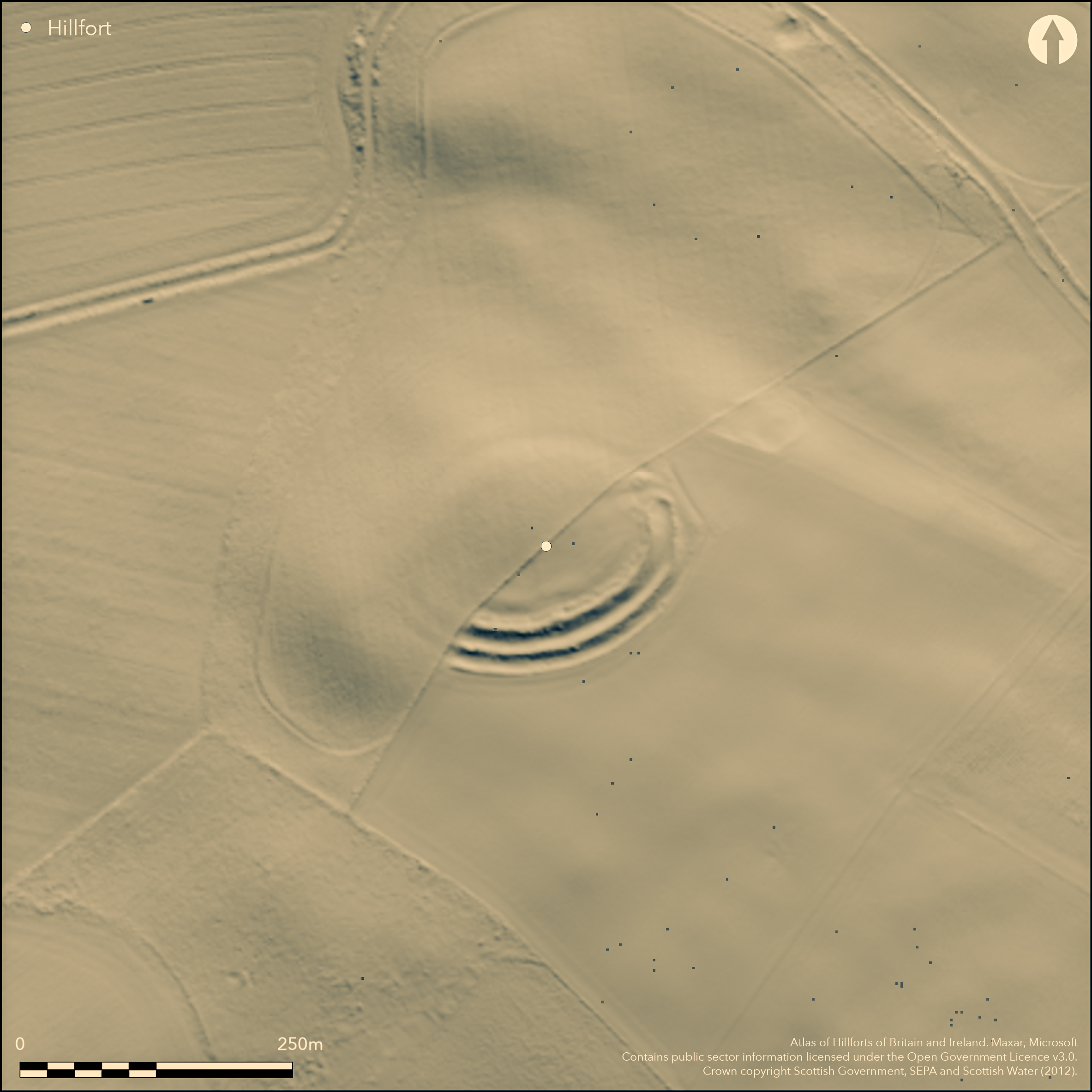
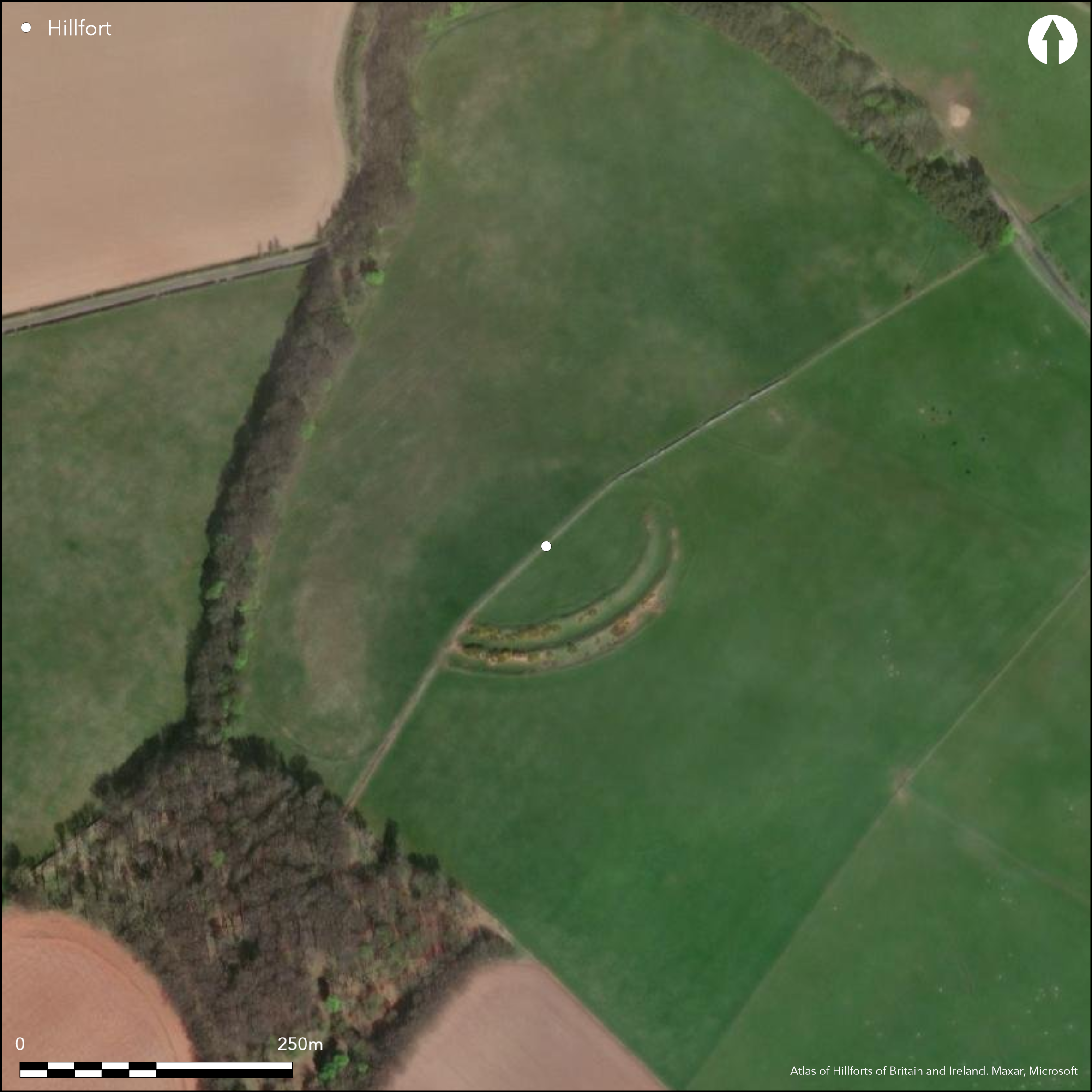
This fort is situated on the NW end of a broad ridge which terminates in a steep escarpment and provides a commanding prospect of the country from Eyemouth on the coast to the N round to Foulden on the SSW. It lies on the parish boundary between Ayton and Mordington, which has evidently also served as a property boundary, leading to widely different levels of preservation to either side, and while the defences in Mordington on the SE of the boundary are amongst the best preserved in the whole of Berwickshire, those on the escarpment on the NW have been virtually obliterated. Nevertheless, the fort has been oval on plan, measuring 100m from NE to SW by 80m transversely (0.63ha) within the innermost rampart, though in the surviving sector this is accompanied by an internal quarry scoop some 8m in breadth by 0.5m in depth, and there are also slight traces of a raised lip along its inner scarp. Around the SE half the defences comprise twin ramparts with external ditches about 6m in breadth and an outer counterscarp bank; while the inner rampart measures over 8m in thickness and still stands up to 3.2m above the inner ditch, the middle rampart is about 6m in thickness and rises 2.3m above the outer ditch; the outer bank on the counterscarp of the outer ditch is minor by comparison, measuring no more than 2.3m in thickness by 0.5m in height. Together they form a belt about 29m deep, and though this is the most accessible side, there is no reason to believe that the defences were any less round the NW, where the line of only the inner rampart and its ditch can be traced on the ground with any confidence. An entrance on the NE with traces of a worn hollow riding up the slope into the interior preserves evidence of the innermost and middle ramparts returning to unite around the terminal of the ditch on the SE side, forming a bank up to 4m thick by 1m high flanking the entrance way, which is itself about 4.8m wide; there are also possible traces of an opposed entrance in the ploughed down sector on the SW. The greater part of the interior has been under plough and there is no evidence of any internal structures.
Citizen Science: ✗
Reliability of Data: Confirmed
Reliability of Interpretation: Confirmed
X: -232727 Y: 7523171 (EPSG: 3857)
Longitude: -2.09062184476019 Latitude: 55.822547367973975 (EPSG:4326)
Country: Scotland; None
Current County or Unitary Authority: Scottish Borders
Historic County: Berwickshire
Current Parish/Community/Council/Townland: Mordington; Ayton
Half the defences ploughed down
| Extant | ✓ |
| Cropmark | ✗ |
| Likely Destroyed | ✓ |
None
| Woodland | ✗ |
| Commercial Forestry Plantation | ✗ |
| Parkland | ✗ |
| Pasture (Grazing) | ✓ |
| Arable | ✓ |
| Scrub/Bracken | ✗ |
| Bare Outcrop | ✗ |
| Heather/Moorland | ✗ |
| Heath | ✗ |
| Built-up | ✗ |
| Coastal Grassland | ✗ |
| Other | ✗ |
None
| Contour Fort | ✓ |
| Partial Contour Fort | ✗ |
| Promontory Fort | ✗ |
| Hillslope Fort | ✗ |
| Level Terrain Fort | ✗ |
| Marsh Fort | ✗ |
| Multiple Enclosure Fort | ✗ |
| Hilltop | ✓ |
| Coastal Promontory | ✗ |
| Inland Promontory | ✗ |
| Valley Bottom | ✗ |
| Knoll/Hillock/Outcrop | ✗ |
| Ridge | ✗ |
| Cliff/Plateau-edge/Scarp | ✗ |
| Hillslope | ✗ |
| Lowland | ✗ |
| Spur | ✗ |
Dominant Topographic Feature: None
| North | ✗ |
| Northeast | ✗ |
| East | ✗ |
| Southeast | ✗ |
| South | ✗ |
| Southwest | ✗ |
| West | ✗ |
| Northwest | ✗ |
| Level | ✓ |
Altitude: 212.0m
Boundary Type: Parish/Townland
In the absence of excavation, there are neither stratified artefacts nor radiocarbon dates to provide a chronology for the defences.
Reliability: D - None
| Pre 1200BC | ✗ |
| 1200BC - 800BC | ✗ |
| 800BC - 400BC | ✗ |
| 400BC - AD50 | ✗ |
| AD50 - AD400 | ✗ |
| AD400 - AD 800 | ✗ |
| Post AD800 | ✗ |
| Unknown | ✓ |
| Pre Hillfort: | None |
| Post Hillfort: | The NW half was demolished and ploughed down by 1834 |
Photographed by R Strathie in 1996 and by RCAHMS Aerial Survey Programme in 1999, 2001 and 2007
| 1st Identified Map Depiction (1771): | Concentric ring on a hill symbol on Andrew and Mostyn Armstrong's Map of the County of Berwick (1771) |
| Other (1834): | Description (NSA, Berwickshire, 134-5) |
| Other (1856): | Annotated Camp on the 1st edition OS 25-inch map (Berwick 1860, sheet 12.13) |
| Other (1894): | description by David Christison (1895, 169-70) |
| Other (1908): | Description (RCAHMS 1909, 48, no.234) |
| Earthwork Survey (1912): | Plan by James Hewat Craw and description (RCAHMS 1915, 153-4, no.270, fig 146; RCAHMS BWD 17/1; BWD 17/1/6 & DP229124) |
| Other (1954): | Visited by the OS |
| Other (1970): | Resurveyed at 1:2500 by the OS |
| Other (1979): | Description RCAHMS |
| Other (1989): | Scheduled |
| Other (1993): | Re-Scheduled |
Featureless apart from the internal quarry scoop to the rear of the rampart
None
| None | ✓ |
| Spring | ✗ |
| Stream | ✗ |
| Pool | ✗ |
| Flush | ✗ |
| Well | ✗ |
| Other | ✗ |
None
| No Known Features | ✗ |
| Round Stone Structures | ✗ |
| Rectangular Stone Structures | ✗ |
| Curvilinear Platforms | ✗ |
| Other Roundhouse Evidence | ✗ |
| Pits | ✗ |
| Quarry Hollows | ✓ |
| Other | ✗ |
None
| No Known Excavation | ✓ |
| Pits | ✗ |
| Postholes | ✗ |
| Roundhouses | ✗ |
| Rectangular Structures | ✗ |
| Roads/Tracks | ✗ |
| Quarry Hollows | ✗ |
| Other | ✗ |
| Nothing Found | ✗ |
None
| No Known Geophysics | ✓ |
| Pits | ✗ |
| Roundhouses | ✗ |
| Rectangular Structures | ✗ |
| Roads/Tracks | ✗ |
| Quarry Hollows | ✗ |
| Other | ✗ |
| Nothing Found | ✗ |
None
| No Known Finds | ✓ |
| Pottery | ✗ |
| Metal | ✗ |
| Metalworking | ✗ |
| Human Bones | ✗ |
| Animal Bones | ✗ |
| Lithics | ✗ |
| Environmental | ✗ |
| Other | ✗ |
Quarry scoop behind the inner rampart with traces of a raised inner lip
| APs Not Checked | ✗ |
| None | ✗ |
| Roundhouses | ✗ |
| Rectangular Structures | ✗ |
| Pits | ✗ |
| Postholes | ✗ |
| Roads/Tracks | ✗ |
| Other | ✓ |
See main summary
| 2: | Half the circuit is ploughed flat |
| 2: | None |
Guard Chambers: ✗
Chevaux de Frise: ✗
| 1. Passage-way/Corridor (North east): | The inner and middle ramparts have returned and united around the terminals of the inner ditch |
| 2. Simple Gap (South west): | Faint traces of a gap in the ploughed down line of the inner rampart |
Twin ramparts with external ditches and an outer counterscarp bank
| Area 1: | 0.63ha. |
| Total: | 0.63ha. |
Total Footprint Area: Noneha.
None
| ✗ | None |
| ✓ | None |
| NE Quadrant: | 2 |
| SE Quadrant: | 2 |
| SW Quadrant: | 2 |
| NW Quadrant: | 1 |
| Total: | 2 |
| Partial Univallate | ✓ |
| Univallate | ✗ |
| Partial Bivallate | ✓ |
| Bivallate | ✗ |
| Partial Multivallate | ✗ |
| Multivallate | ✗ |
| Unknown | ✗ |
| Partial Univallate | ✗ |
| Univallate | ✗ |
| Partial Bivallate | ✗ |
| Bivallate | ✗ |
| Partial Multivallate | ✗ |
| Multivallate | ✗ |
None
| None | ✗ |
| Earthen Bank | ✓ |
| Stone Wall | ✗ |
| Rubble | ✗ |
| Wall-walk | ✗ |
| Evidence of Timber | ✗ |
| Vitrification | ✗ |
| Other Burning | ✗ |
| Palisade | ✗ |
| Counter Scarp Bank | ✓ |
| Berm | ✗ |
| Unfinished | ✗ |
| Other | ✗ |
None
| None | ✗ |
| Earthen Bank | ✗ |
| Stone Wall | ✗ |
| Murus Duplex | ✗ |
| Timber-framed | ✗ |
| Timber-laced | ✗ |
| Vitrification | ✗ |
| Other Burning | ✗ |
| Palisade | ✗ |
| Counter Scarp Bank | ✗ |
| Berm | ✗ |
| Unfinished | ✗ |
| No Known Excavation | ✓ |
| Other | ✗ |
| ✗ | None |
| ✓ | None |
Number of Ditches: 2
| ✗ | None |
Christison, D (1895) 'The forts of Selkirk, the Gala Water, the Southern slopes of the Lammermoors, and the north of Roxburgh'. Proc Soc Antiq Scot 29 (1894-50), 108-79
Feachem, R W (1963) A guide to prehistoric Scotland. Batsford: London (p 112-13)
NSA (1834-1845) The new statistical account of Scotland by the ministers of the respective parishes under the superintendence of a committee of the society for the benefit of the sons and daughters of the clergy.
RCAHMS (1909) The Royal Commission on the Ancient and Historical Monuments and Constructions of Scotland. First report and Inventory of Monuments and Constructions in the County of Berwick. HMSO: Edinburgh.
RCAHMS (1915) The Royal Commission on the Ancient and Historical Monuments and Constructions of Scotland. Sixth report and Inventory of Monuments and Constructions in the County of Berwick (Revised Issue). HMSO: Edinburgh
Atlas of Hillforts:
Wikidata:
This work is licensed under CC BY-SA 4.0![]()
![]()
![]() and should be cited as:
and should be cited as:
Lock, Gary and Ralston, Ian. 2024. Atlas of Hillforts of Britain and Ireland. Available at: https://hillforts.arch.ox.ac.uk
Document Version 1.1