Satellite Imagery
Satellite Imagery
HER: Shetland Amenity Trust 21 (None)
NMR: HP 40 SE 1 (4)
SM: 11274
NGR: HP 4781 0338
X: 447810 Y: 1203380 (OSGB36)
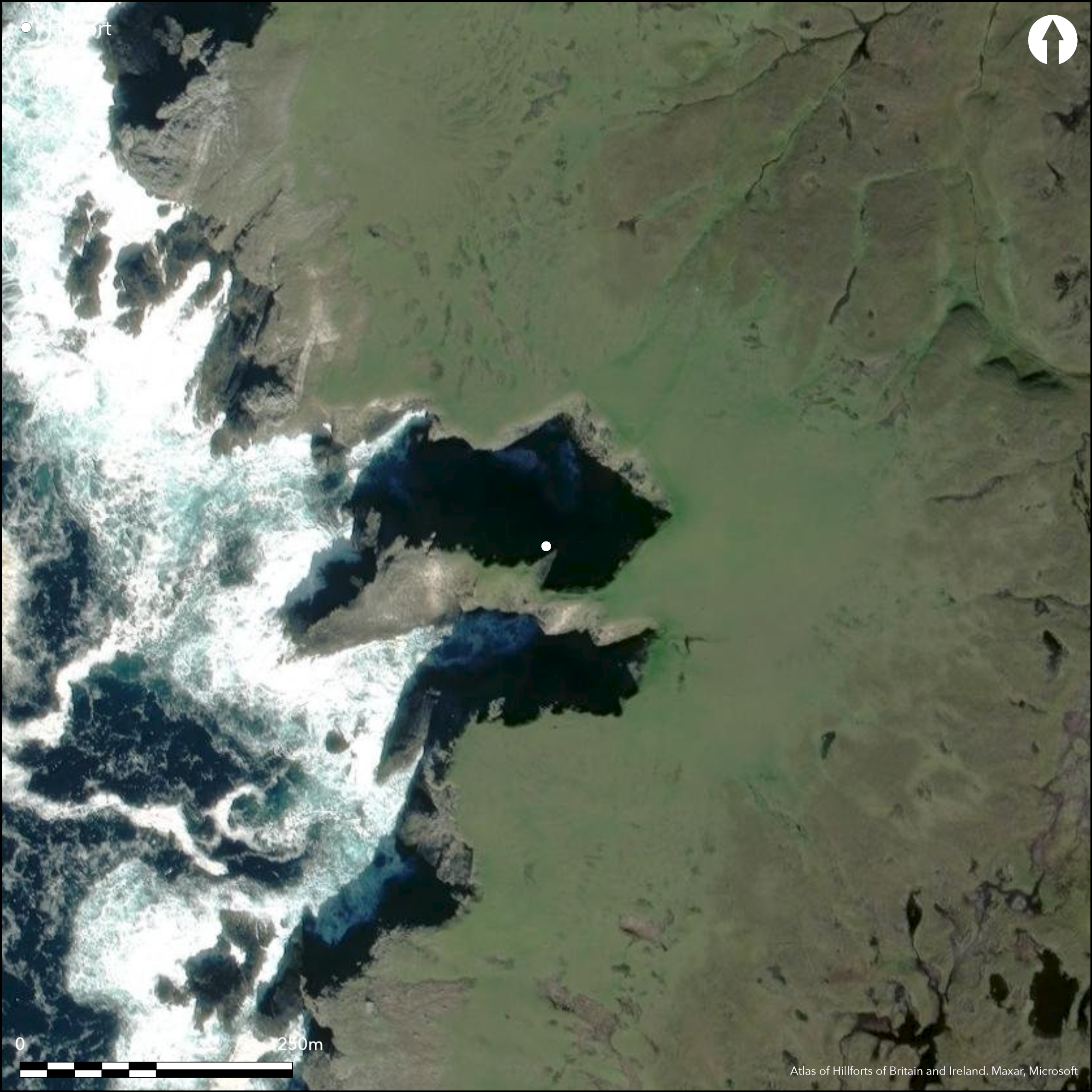
This fort stands on a precipitous promontory on the NW coast of the island of Yell, in what is today one of the most remote spots in the British Isles. Approached from the E, the entrance way leading onto the narrow isthmus is lined for a distance of about 8m on the N by a row of slabs, perhaps the revetment of a wall that has slipped over the cliff, while on the S it is flanked by a mound studded with upright stones, apparently forming a chevaux de frise rather than the remains of any structure. From there the path descends to a narrow rocky neck, before climbing to confront the inner defences, comprising a rectangular blockhouse set slightly to one side, with a walled enclosure to its rear. The blockhouse measures 6.7m in length by 4.25m in breadth, and the enclosure to its rear, which is only some 12m across overall, is apparently butted on at the NE and SW corners respectively. No entrance is visible into the blockhouse, which is positioned to allow access between its S end and the cliff-edge to the seaward end of the promontory. There, at the edge of its S side, Raymond Lamb recovered two sherds of pottery from the cliff section and evidence of occupation in the bottom of a shallow hollow which he interpreted as the remains of a round building; he also observed traces of several other similar hollows, though these do not appear on his plan. The summit of the promontory has evidently been reduced by erosion and the irregular area to the rear of the blockhouse barely measures 22m from E to W by 10m transversely (0.02ha).
Citizen Science: ✗
Reliability of Data: Confirmed
Reliability of Interpretation: Confirmed
X: -125320 Y: 8559730 (EPSG: 3857)
Longitude: -1.1257682253750634 Latitude: 60.710850725166544 (EPSG:4326)
Country: Scotland
Current County or Unitary Authority: Shetland Islands
Historic County: Shetland
Current Parish/Community/Council/Townland: Yell
None
| Extant | ✓ |
| Cropmark | ✗ |
| Likely Destroyed | ✗ |
None
| Woodland | ✗ |
| Commercial Forestry Plantation | ✗ |
| Parkland | ✗ |
| Pasture (Grazing) | ✗ |
| Arable | ✗ |
| Scrub/Bracken | ✗ |
| Bare Outcrop | ✗ |
| Heather/Moorland | ✓ |
| Heath | ✗ |
| Built-up | ✗ |
| Coastal Grassland | ✗ |
| Other | ✗ |
None
| Contour Fort | ✗ |
| Partial Contour Fort | ✗ |
| Promontory Fort | ✓ |
| Hillslope Fort | ✗ |
| Level Terrain Fort | ✗ |
| Marsh Fort | ✗ |
| Multiple Enclosure Fort | ✗ |
| Hilltop | ✗ |
| Coastal Promontory | ✓ |
| Inland Promontory | ✗ |
| Valley Bottom | ✗ |
| Knoll/Hillock/Outcrop | ✗ |
| Ridge | ✗ |
| Cliff/Plateau-edge/Scarp | ✗ |
| Hillslope | ✗ |
| Lowland | ✗ |
| Spur | ✗ |
Dominant Topographic Feature: None
| North | ✗ |
| Northeast | ✗ |
| East | ✗ |
| Southeast | ✗ |
| South | ✗ |
| Southwest | ✗ |
| West | ✗ |
| Northwest | ✗ |
| Level | ✓ |
Altitude: 45.0m
N/A
In the absence of excavation, there are neither stratified artefacts nor radiocarbon dates to provide a chronology for the defences.
Reliability: D - None
| Pre 1200BC | ✗ |
| 1200BC - 800BC | ✗ |
| 800BC - 400BC | ✗ |
| 400BC - AD50 | ✗ |
| AD50 - AD400 | ✗ |
| AD400 - AD 800 | ✗ |
| Post AD800 | ✗ |
| Unknown | ✓ |
| Pre Hillfort: | None |
| Post Hillfort: | None |
None
| 1st Identified Written Reference (1853): | Sketched by James T Irvine (RCAHMS 1946, iii, 164 fig 674. Referenced to the Society of Antiquaries of Scotland: Shetland Historical Collections. Notes and Queries; Orkney and Shetland. Irvine's miscellanea) |
| 1st Identified Map Depiction (1878): | Annotated Brough on the 1st edition OS 6-inch map (Shetland 1881, sheet 7) |
| Other (1931): | Description (RCAHMS 1946, iii, 163-4, no.1724; RCAHMS MS 36/112) |
| Other (1969): | Visited by the OS |
| Earthwork Survey (1970): | Plan and description by Raymond Lamb (1980, 27-33 fig 10, 84-5; RCAHMS SHD 33/2) |
| Other (2006): | Scheduled |
A walled enclosure behind the blockhouse and several hollows at the seaward end that may mark the positions of structures
None
| None | ✓ |
| Spring | ✗ |
| Stream | ✗ |
| Pool | ✗ |
| Flush | ✗ |
| Well | ✗ |
| Other | ✗ |
Blockhouse
| No Known Features | ✗ |
| Round Stone Structures | ✗ |
| Rectangular Stone Structures | ✗ |
| Curvilinear Platforms | ✓ |
| Other Roundhouse Evidence | ✗ |
| Pits | ✗ |
| Quarry Hollows | ✗ |
| Other | ✓ |
None
| No Known Excavation | ✓ |
| Pits | ✗ |
| Postholes | ✗ |
| Roundhouses | ✗ |
| Rectangular Structures | ✗ |
| Roads/Tracks | ✗ |
| Quarry Hollows | ✗ |
| Other | ✗ |
| Nothing Found | ✗ |
None
| No Known Geophysics | ✓ |
| Pits | ✗ |
| Roundhouses | ✗ |
| Rectangular Structures | ✗ |
| Roads/Tracks | ✗ |
| Quarry Hollows | ✗ |
| Other | ✗ |
| Nothing Found | ✗ |
Two sherd of pottery (Shetland Museum)
| No Known Finds | ✗ |
| Pottery | ✓ |
| Metal | ✗ |
| Metalworking | ✗ |
| Human Bones | ✗ |
| Animal Bones | ✗ |
| Lithics | ✗ |
| Environmental | ✗ |
| Other | ✗ |
NO APPARENT FEATURES
| APs Not Checked | ✗ |
| None | ✓ |
| Roundhouses | ✗ |
| Rectangular Structures | ✗ |
| Pits | ✗ |
| Postholes | ✗ |
| Roads/Tracks | ✗ |
| Other | ✗ |
See main summary
| 1: | None |
| 2: | None |
Guard Chambers: ✗
Chevaux de Frise: ✓
| 1. Passage-way/Corridor (East): | Long defined approach along the neck, with possible remains of a wall on one side and a mound studded with chevaux de frise on the other |
Blockhouse forming the inner defence on a promontory, with outer defences on the neck comprising a defined entrance-way and chevaux de frise
| Area 1: | 0.02ha. |
| Total: | 0.02ha. |
Total Footprint Area: Noneha.
None
| ✓ | The small walled enclosure to the rear of the blockhouse is butted on |
| ✗ | None |
| NE Quadrant: | 0 |
| SE Quadrant: | 1 |
| SW Quadrant: | 0 |
| NW Quadrant: | 0 |
| Total: | 1 |
| Partial Univallate | ✓ |
| Univallate | ✗ |
| Partial Bivallate | ✗ |
| Bivallate | ✗ |
| Partial Multivallate | ✗ |
| Multivallate | ✗ |
| Unknown | ✗ |
| Partial Univallate | ✗ |
| Univallate | ✗ |
| Partial Bivallate | ✗ |
| Bivallate | ✗ |
| Partial Multivallate | ✗ |
| Multivallate | ✗ |
Blockhouse
| None | ✗ |
| Earthen Bank | ✗ |
| Stone Wall | ✓ |
| Rubble | ✗ |
| Wall-walk | ✗ |
| Evidence of Timber | ✗ |
| Vitrification | ✗ |
| Other Burning | ✗ |
| Palisade | ✗ |
| Counter Scarp Bank | ✗ |
| Berm | ✗ |
| Unfinished | ✗ |
| Other | ✓ |
None
| None | ✗ |
| Earthen Bank | ✗ |
| Stone Wall | ✗ |
| Murus Duplex | ✗ |
| Timber-framed | ✗ |
| Timber-laced | ✗ |
| Vitrification | ✗ |
| Other Burning | ✗ |
| Palisade | ✗ |
| Counter Scarp Bank | ✗ |
| Berm | ✗ |
| Unfinished | ✗ |
| No Known Excavation | ✓ |
| Other | ✗ |
| ✗ | None |
| ✗ | None |
Number of Ditches: None
| ✗ | None |
Lamb, R G (1980) Iron Age promontory forts in the Northern Isles. Brit Archaeol Rep, British Ser 79. BAR: Oxford: plan at fig. 10, p.28.
RCAHMS (1946) The Royal Commission on the Ancient and Historical Monuments of Scotland. Twelfth report with an inventory of the ancient monuments of Orkney and Shetland, 3v. HMSO: Edinburgh
Atlas of Hillforts:
Wikidata:
This work is licensed under CC BY-SA 4.0![]()
![]()
![]() and should be cited as:
and should be cited as:
Lock, Gary and Ralston, Ian. 2024. Atlas of Hillforts of Britain and Ireland. Available at: https://hillforts.arch.ox.ac.uk
Document Version 1.1