LiDAR 1m DTM Hillshade
Satellite Imagery
LiDAR 1m DTM Hillshade
Satellite Imagery
Scroll left/right to view further images.
HER: Shetland Amenity Trust 557 (None)
NMR: HU 30 NE 2 (515)
SM: 90226
NGR: HU 3878 0839
X: 438780 Y: 1108390 (OSGB36)
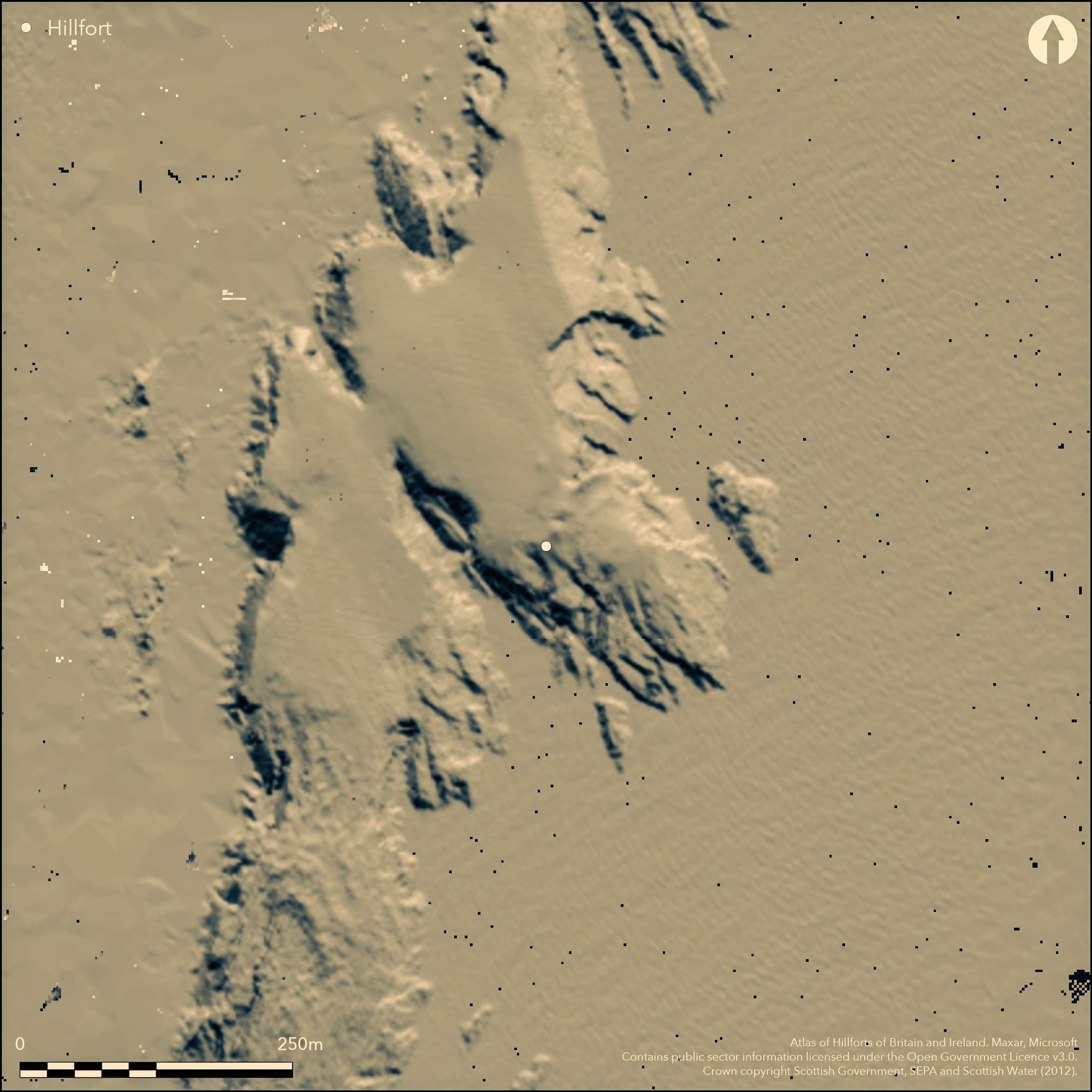
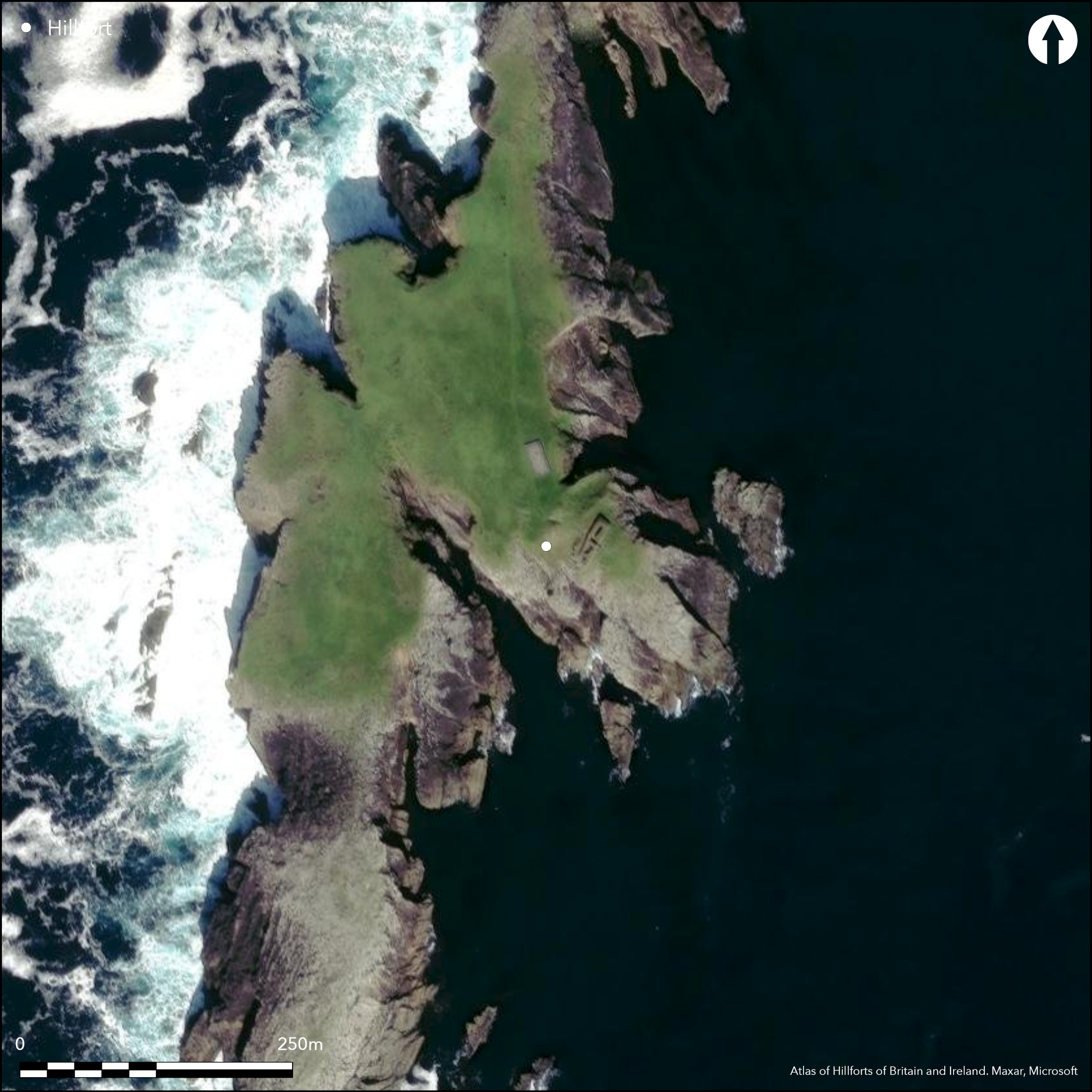
This fort occupies a rugged cliff-girt promontory on the E side of the peninsula running out to the Hog of Ness and sheltering the W flank of the West Voe of Sumburgh. The defences comprise a blockhouse facing WNE onto the inner of two broad ditches with a medial rampart, which bar access to an area on the top of the promontory measuring about 30m in length from NW to SE by 25m in breadth (0.07ha), though a much larger area of sloping outcrops descends to the sea on the ESE. The blockhouse was excavated in 1935 (Mowbray 1936) and subsequently in 1971 restored, comprising a rectangular block, which though eroded at one end, measures at least 23.8m in length by between 5.6m and 6.4m in breadth. A lintelled entrance passage with checks and a bar-hole towards the outer end leads through the centre of the block and has a doorway into a chamber on its N side, while a second chamber with an independent entrance opening into the interior lies immediately SSW of the passage, and a smaller third chamber in the partly destroyed SSW end. Two hearths representing successive occupations were found in the chamber on the SSW side of the entrance, and the earlier was associated with a number of cobbles set on end at the doorway. The entrance opens outwards onto the rocky scarp rising up some 3.5m above the bottom of the inner ditch, and lies roughly opposite the mouth of a passage aligned E and W through the medial rampart, but there may also have been access to the rest of the promontory around its NNE end, where the block stops well short of the cliff-edge, and the inner ditch likewise has not been cut all the way through the outcrops. The excavations recovered a range of pottery and midden from within the blockhouse, while two carved discs found in a 'Broch ...on the rocky point Scatness (Smith 1883, 296-7) are also considered to have come from here. Reassessment of the sherds found in 1935 tentatively assigns a date of 200 BC to AD 200 (Carter et al 1995, 447), though how these relate to the construction of the blockhouse is unknown.
Citizen Science: ✗
Reliability of Data: Confirmed
Reliability of Interpretation: Confirmed
X: -145765 Y: 8368411 (EPSG: 3857)
Longitude: -1.3094276111152263 Latitude: 59.85899534687815 (EPSG:4326)
Country: Scotland
Current County or Unitary Authority: Shetland Islands
Historic County: Shetland
Current Parish/Community/Council/Townland: Dunrossness
None
| Extant | ✓ |
| Cropmark | ✗ |
| Likely Destroyed | ✗ |
None
| Woodland | ✗ |
| Commercial Forestry Plantation | ✗ |
| Parkland | ✗ |
| Pasture (Grazing) | ✓ |
| Arable | ✗ |
| Scrub/Bracken | ✗ |
| Bare Outcrop | ✗ |
| Heather/Moorland | ✓ |
| Heath | ✗ |
| Built-up | ✗ |
| Coastal Grassland | ✗ |
| Other | ✗ |
None
| Contour Fort | ✗ |
| Partial Contour Fort | ✗ |
| Promontory Fort | ✓ |
| Hillslope Fort | ✗ |
| Level Terrain Fort | ✗ |
| Marsh Fort | ✗ |
| Multiple Enclosure Fort | ✗ |
| Hilltop | ✗ |
| Coastal Promontory | ✓ |
| Inland Promontory | ✗ |
| Valley Bottom | ✗ |
| Knoll/Hillock/Outcrop | ✗ |
| Ridge | ✗ |
| Cliff/Plateau-edge/Scarp | ✗ |
| Hillslope | ✗ |
| Lowland | ✗ |
| Spur | ✗ |
Dominant Topographic Feature: None
| North | ✗ |
| Northeast | ✗ |
| East | ✗ |
| Southeast | ✗ |
| South | ✗ |
| Southwest | ✗ |
| West | ✗ |
| Northwest | ✗ |
| Level | ✓ |
Altitude: 15.0m
N/A
The undecorated sherds recovered in 1935 were reassessed in 1995 and on analogy with material from Kebister were tentatively assigned a date about 200 BC to AD 200 (Carter et al 1995), thus providing a rough terminus ante quem for the blockhouse
Reliability: C - Low
| Pre 1200BC | ✗ |
| 1200BC - 800BC | ✗ |
| 800BC - 400BC | ✗ |
| 400BC - AD50 | ✓ |
| AD50 - AD400 | ✓ |
| AD400 - AD 800 | ✗ |
| Post AD800 | ✗ |
| Unknown | ✗ |
| Pre Hillfort: | None |
| Post Hillfort: | None |
| Artefactual: | Undecorated sherds |
In addition to the defences of the promontory fort, Cecil Mowbray (1936, 382) noted a 'low rampart' at the narrow neck where the path crossed over a natural arch to gain access to the otherwise isolated headland. Raymond Lamb, however, refers to this merely as a 'stone-revetted bank' (1980, 81) and does not seem to have considered that it was of any great antiquity; subsequently in 1974 Joanna Close-Brooks noted 'two sets of single rampart, cliff edge to cliff edge' (RCAHMS Canmore 520). The grass-grown portion of this headland beyond the arch extends for about 320m (2.2ha), and runs out a further 350m as a spit of bare rock. In common with many other such headlands, these are likely to be the remains of agricultural boundaries rather than defences.
| 1st Identified Map Depiction (1877): | Annotated Brough on the 1st edition OS 6-inch map (Shetland 1882, sheet 67) |
| Other (1882): | Two carved stone discs reported (Smith 1883, 296-7) |
| Earthwork Survey (1930): | Plan and description (RCAHMS 1946, iii, 34-6, no.1154, figs 502 & 508; RCAHMS SHD 39/1-5) |
| Other (1934): | Scheduled (Taken into Care) |
| Excavation (1935): | By Cecil Mowbray (1936; archive held by RCAHMS) |
| Other (1963): | Description by Euan Mackie (2002, 73-4) |
| Other (1968): | Visited by the OS |
| Other (1970): | By Raymond Lamb after RCAHMS (1980, 10 fig 4, 81; RCAHMS SHD 39/6) |
| Other (1971): | Restoration of the blockhouse by Ancient Monuments Directorate, DoE |
| Excavation (1983): | Trench dug across the medial rampart by Peter Strong (Carter et al 1995, 446-7, 473-7; archive held by RCAHMS) |
Featureless apart from the blockhouse
None
| None | ✓ |
| Spring | ✗ |
| Stream | ✗ |
| Pool | ✗ |
| Flush | ✗ |
| Well | ✗ |
| Other | ✗ |
Blockhouse
| No Known Features | ✗ |
| Round Stone Structures | ✗ |
| Rectangular Stone Structures | ✗ |
| Curvilinear Platforms | ✗ |
| Other Roundhouse Evidence | ✗ |
| Pits | ✗ |
| Quarry Hollows | ✗ |
| Other | ✓ |
Blockhouse
| No Known Excavation | ✗ |
| Pits | ✗ |
| Postholes | ✗ |
| Roundhouses | ✗ |
| Rectangular Structures | ✓ |
| Roads/Tracks | ✗ |
| Quarry Hollows | ✗ |
| Other | ✗ |
| Nothing Found | ✗ |
None
| No Known Geophysics | ✓ |
| Pits | ✗ |
| Roundhouses | ✗ |
| Rectangular Structures | ✗ |
| Roads/Tracks | ✗ |
| Quarry Hollows | ✗ |
| Other | ✗ |
| Nothing Found | ✗ |
Range of pottery, animal bones and a fragment of a sandstone vessel were found in the 1935 excavations (Mowbray 1936)
| No Known Finds | ✗ |
| Pottery | ✓ |
| Metal | ✗ |
| Metalworking | ✗ |
| Human Bones | ✗ |
| Animal Bones | ✓ |
| Lithics | ✗ |
| Environmental | ✗ |
| Other | ✓ |
Blockhouse
| APs Not Checked | ✗ |
| None | ✗ |
| Roundhouses | ✗ |
| Rectangular Structures | ✗ |
| Pits | ✗ |
| Postholes | ✗ |
| Roads/Tracks | ✗ |
| Other | ✓ |
See main summary
| 2: | There is also the gap at the NNE end of the blockhouse |
| 2: | None |
Guard Chambers: ✗
Chevaux de Frise: ✗
| 1. Other Forms (North west): | Checked entrance with bar-holes through the blockhouse |
A blockhouse, two ditches and a medial rampart barring access to a promontory. In addition to these defences, Cecil Mowbray (1936, 382) noted a 'low rampart' at the narrow neck where the path crossed over a natural arch to gain access to the otherwise isolated headland. Raymond Lamb, however, refers to this merely as a 'stone-revetted bank' (1980, 81) and does not seem to have considered it that it was of any great antiquity; The grass-grown portion of this headland beyond the arch extends for about 320m (2.2ha), and runs out a further 350m as a spit of bare rock.
| Area 1: | 0.07ha. |
| Total: | 0.07ha. |
Total Footprint Area: Noneha.
None
| ✗ | None |
| ✗ | None |
| NE Quadrant: | 0 |
| SE Quadrant: | 0 |
| SW Quadrant: | 0 |
| NW Quadrant: | 2 |
| Total: | 2 |
| Partial Univallate | ✗ |
| Univallate | ✗ |
| Partial Bivallate | ✓ |
| Bivallate | ✗ |
| Partial Multivallate | ✗ |
| Multivallate | ✗ |
| Unknown | ✗ |
| Partial Univallate | ✗ |
| Univallate | ✗ |
| Partial Bivallate | ✗ |
| Bivallate | ✗ |
| Partial Multivallate | ✗ |
| Multivallate | ✗ |
Blockhouse and stone-faced rampart
| None | ✗ |
| Earthen Bank | ✗ |
| Stone Wall | ✓ |
| Rubble | ✗ |
| Wall-walk | ✗ |
| Evidence of Timber | ✗ |
| Vitrification | ✗ |
| Other Burning | ✗ |
| Palisade | ✗ |
| Counter Scarp Bank | ✗ |
| Berm | ✗ |
| Unfinished | ✗ |
| Other | ✓ |
Blockhouse
| None | ✗ |
| Earthen Bank | ✗ |
| Stone Wall | ✓ |
| Murus Duplex | ✗ |
| Timber-framed | ✗ |
| Timber-laced | ✗ |
| Vitrification | ✗ |
| Other Burning | ✗ |
| Palisade | ✗ |
| Counter Scarp Bank | ✗ |
| Berm | ✗ |
| Unfinished | ✗ |
| No Known Excavation | ✗ |
| Other | ✓ |
| ✗ | None |
| ✓ | None |
Number of Ditches: 2
| ✗ | None |
Carter, S P, McCullagh, R P J and MacSween, A (1995) 'The Iron Age in Shetland: excavations at five sites threatened by coastal erosion'. Proc Soc Antiq Scot 125 (1995), 429-82
Lamb, R G (1980) Iron Age promontory forts in the Northern Isles. Brit Archaeol Rep, British Ser 79. BAR: Oxford
MacKie, E W (2002) The roundhouses, brochs and wheelhouses of Atlantic Scotland c. 700BC - AD500: architecture and material culture Part 1 - The Orkney and Shetland Isles. BAR British Series 342: Oxford
Mowbray, C L (1936) 'Excavation at the Ness of Burgi, Shetland'. Proc Soc Antiq Scot 70 (1935-6), 381-7
RCAHMS (1946) The Royal Commission on the Ancient and Historical Monuments of Scotland. Twelfth report with an inventory of the ancient monuments of Orkney and Shetland, 3v. HMSO: Edinburgh
Smith, J A (1883) 'Notes on some implements, etc, from Shetland, now presented to the museum'. Proc Soc Antiq Scot 17 (1882-3), 291-9
Atlas of Hillforts:
Wikidata:
This work is licensed under CC BY-SA 4.0![]()
![]()
![]() and should be cited as:
and should be cited as:
Lock, Gary and Ralston, Ian. 2024. Atlas of Hillforts of Britain and Ireland. Available at: https://hillforts.arch.ox.ac.uk
Document Version 1.1