Satellite Imagery
Satellite Imagery
HER: Shetland Amenity Trust 475 (None)
NMR: HU 39 SE 4 (883)
SM: 3880
NGR: HU 3816 9150
X: 438160 Y: 1191500 (OSGB36)
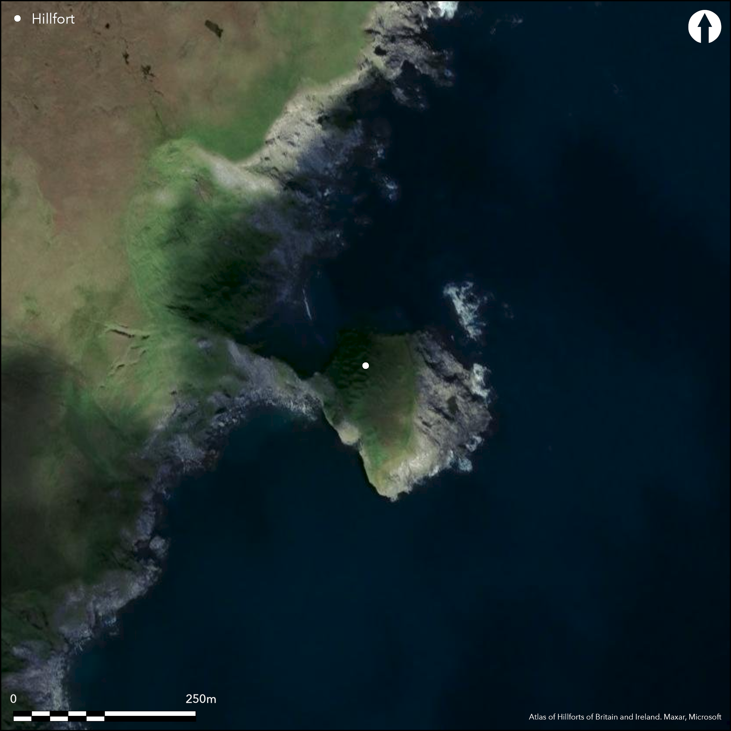
The Kame of Isbister is a rugged coastal promontory with a distinctive sloping profile dropping down seaward from the rocky crest overlooking the narrow neck. It was formerly approached along the razor-backed spine of the neck, where access was impeded by a natural boss of rock, from which the outcrops rose to form a natural rampart along the crest of the promontory. There is no record of any artificial works or defences, but the natural character of the topography is sufficiently difficult to justify its inclusion with other coastal fortifications on promontories; indeed, continued erosion along the neck has now rendered the promontory inaccessible to any casual visit. Behind the rocky crest, the ground on the E drops down towards the sea, the upper portion being grass-grown and measuring 90m from N to S by up to 38m transversely (0.25ha), beyond which the sloping outcrops drop a further 40m down to the sea. In 1876, George Cockburn counted no fewer than twenty-three rectangular buildings on the grassy slope, excavating in two of them (Gordon 1878), while a plan drawn up by the OS in 1970 shows nineteen, the majority of them set side by side along the upper margin immediately below the crest of the promontory. While it was suggested in the 19th century that this may be a relatively recent fishing station, the isolation and difficulties of access, coupled with analogies elsewhere in the Northern Isles suggests an early medieval monastic origin (Lamb 1973; 1976).
Citizen Science: ✗
Reliability of Data: Confirmed
Reliability of Interpretation: Unconfirmed
X: -145257 Y: 8535737 (EPSG: 3857)
Longitude: -1.304870217828723 Latitude: 60.605232896839674 (EPSG:4326)
Country: Scotland
Current County or Unitary Authority: Shetland Islands
Historic County: Shetland
Current Parish/Community/Council/Townland: Northmavine
None
| Extant | ✓ |
| Cropmark | ✗ |
| Likely Destroyed | ✗ |
None
| Woodland | ✗ |
| Commercial Forestry Plantation | ✗ |
| Parkland | ✗ |
| Pasture (Grazing) | ✗ |
| Arable | ✗ |
| Scrub/Bracken | ✗ |
| Bare Outcrop | ✗ |
| Heather/Moorland | ✗ |
| Heath | ✗ |
| Built-up | ✗ |
| Coastal Grassland | ✓ |
| Other | ✗ |
None
| Contour Fort | ✗ |
| Partial Contour Fort | ✗ |
| Promontory Fort | ✓ |
| Hillslope Fort | ✗ |
| Level Terrain Fort | ✗ |
| Marsh Fort | ✗ |
| Multiple Enclosure Fort | ✗ |
| Hilltop | ✗ |
| Coastal Promontory | ✓ |
| Inland Promontory | ✗ |
| Valley Bottom | ✗ |
| Knoll/Hillock/Outcrop | ✗ |
| Ridge | ✗ |
| Cliff/Plateau-edge/Scarp | ✗ |
| Hillslope | ✗ |
| Lowland | ✗ |
| Spur | ✗ |
Dominant Topographic Feature: None
| North | ✗ |
| Northeast | ✗ |
| East | ✗ |
| Southeast | ✗ |
| South | ✗ |
| Southwest | ✗ |
| West | ✗ |
| Northwest | ✗ |
| Level | ✓ |
Altitude: 38.0m
N/A
In the absence of modern excavation, there are neither stratified artefacts nor radiocarbon dates to provide a chronology
Reliability: D - None
| Pre 1200BC | ✗ |
| 1200BC - 800BC | ✗ |
| 800BC - 400BC | ✗ |
| 400BC - AD50 | ✗ |
| AD50 - AD400 | ✗ |
| AD400 - AD 800 | ✓ |
| Post AD800 | ✗ |
| Unknown | ✓ |
| Pre Hillfort: | None |
| Post Hillfort: | None |
| Morphology/Earthwork/Typology: | Analogy would suggest an early medieval occupation, probably monastic |
Photographed by RCAHMS Aerial Survey Programme in 2003 ; RCAHMS also old OS aerial photos and views taken by Raymond Lamb from the adjacent cliffs
| Excavation (1876): | Description and sketches by George Cockburn (Gordon 1878, 202, 205-6) |
| 1st Identified Map Depiction (1900): | Annotated Brough on the OS 25-inch map (Shetland 1901, sheet 15.1) |
| Other (1931): | Brief description (RCAHMS 1946, iii, 97, no.1375) |
| Earthwork Survey (1970): | plan at 1:1250 by the OS (Lamb 1973, 76-7, fig 1; RCAHMS DC1915P & SC453286) |
| Other (1976): | Scheduled |
Twenty-three rectangular buildings were counted here in 1876 by George Cockburn, and in 1970 the OS depicted nineteen
None
| None | ✓ |
| Spring | ✗ |
| Stream | ✗ |
| Pool | ✗ |
| Flush | ✗ |
| Well | ✗ |
| Other | ✗ |
None
| No Known Features | ✗ |
| Round Stone Structures | ✗ |
| Rectangular Stone Structures | ✓ |
| Curvilinear Platforms | ✗ |
| Other Roundhouse Evidence | ✗ |
| Pits | ✗ |
| Quarry Hollows | ✗ |
| Other | ✗ |
None
| No Known Excavation | ✓ |
| Pits | ✗ |
| Postholes | ✗ |
| Roundhouses | ✗ |
| Rectangular Structures | ✗ |
| Roads/Tracks | ✗ |
| Quarry Hollows | ✗ |
| Other | ✗ |
| Nothing Found | ✗ |
None
| No Known Geophysics | ✓ |
| Pits | ✗ |
| Roundhouses | ✗ |
| Rectangular Structures | ✗ |
| Roads/Tracks | ✗ |
| Quarry Hollows | ✗ |
| Other | ✗ |
| Nothing Found | ✗ |
None
| No Known Finds | ✓ |
| Pottery | ✗ |
| Metal | ✗ |
| Metalworking | ✗ |
| Human Bones | ✗ |
| Animal Bones | ✗ |
| Lithics | ✗ |
| Environmental | ✗ |
| Other | ✗ |
NO APPARENT FEATURES
| APs Not Checked | ✓ |
| None | ✗ |
| Roundhouses | ✗ |
| Rectangular Structures | ✗ |
| Pits | ✗ |
| Postholes | ✗ |
| Roads/Tracks | ✗ |
| Other | ✗ |
The entrance must have approached along the razor-backed neck from the W
| 0: | None |
| 2: | The entrance must have approached along the razor-backed neck from the W |
Guard Chambers: ✗
Chevaux de Frise: ✗
Evidently a bank along the lower seaward side on the E, and aerial photographs give the impression that the outcrops form a raised lip above the einterior
| Area 1: | 0.25ha. |
| Total: | 0.25ha. |
Total Footprint Area: Noneha.
None
| ✗ | None |
| ✗ | If there are defences here they cut off the promontory from the neck |
| NE Quadrant: | 0 |
| SE Quadrant: | 0 |
| SW Quadrant: | 0 |
| NW Quadrant: | 0 |
| Total: | 0 |
| Partial Univallate | ✗ |
| Univallate | ✗ |
| Partial Bivallate | ✗ |
| Bivallate | ✗ |
| Partial Multivallate | ✗ |
| Multivallate | ✗ |
| Unknown | ✓ |
| Partial Univallate | ✗ |
| Univallate | ✗ |
| Partial Bivallate | ✗ |
| Bivallate | ✗ |
| Partial Multivallate | ✗ |
| Multivallate | ✗ |
None
| None | ✓ |
| Earthen Bank | ✗ |
| Stone Wall | ✗ |
| Rubble | ✗ |
| Wall-walk | ✗ |
| Evidence of Timber | ✗ |
| Vitrification | ✗ |
| Other Burning | ✗ |
| Palisade | ✗ |
| Counter Scarp Bank | ✗ |
| Berm | ✗ |
| Unfinished | ✗ |
| Other | ✗ |
None
| None | ✗ |
| Earthen Bank | ✗ |
| Stone Wall | ✗ |
| Murus Duplex | ✗ |
| Timber-framed | ✗ |
| Timber-laced | ✗ |
| Vitrification | ✗ |
| Other Burning | ✗ |
| Palisade | ✗ |
| Counter Scarp Bank | ✗ |
| Berm | ✗ |
| Unfinished | ✗ |
| No Known Excavation | ✓ |
| Other | ✗ |
| ✗ | None |
| ✗ | None |
Number of Ditches: None
| ✗ | None |
Gordon, G. (1878) Notice of incised sculpturings on the steatite rock at Feideland, the extreme north of the mainland of Shetland, and of a cluster of ruined structures styled Picts houses on the Kaim of Isbister, Shetland', Proc Soc Antiq Scot, vol. 12, 1876-8. Page(s): 202, 205-6
Lamb, R G (1973) 'Coastal settlements of the north'. Scot Archaeol Forum 5 (1973), 76-98
Lamb, R G (1976) 'The Burri Stacks of Culswick, Shetland, and other paired stack-settlements'. Proc Soc Antiq Scot 107 (1975-6), 144-54
Atlas of Hillforts:
Wikidata:
This work is licensed under CC BY-SA 4.0![]()
![]()
![]() and should be cited as:
and should be cited as:
Lock, Gary and Ralston, Ian. 2024. Atlas of Hillforts of Britain and Ireland. Available at: https://hillforts.arch.ox.ac.uk
Document Version 1.1