Satellite Imagery
Satellite Imagery
HER: Shetland Amenity Trust 269 (None)
NMR: HU 49 SW 1 (1262)
SM: 3966
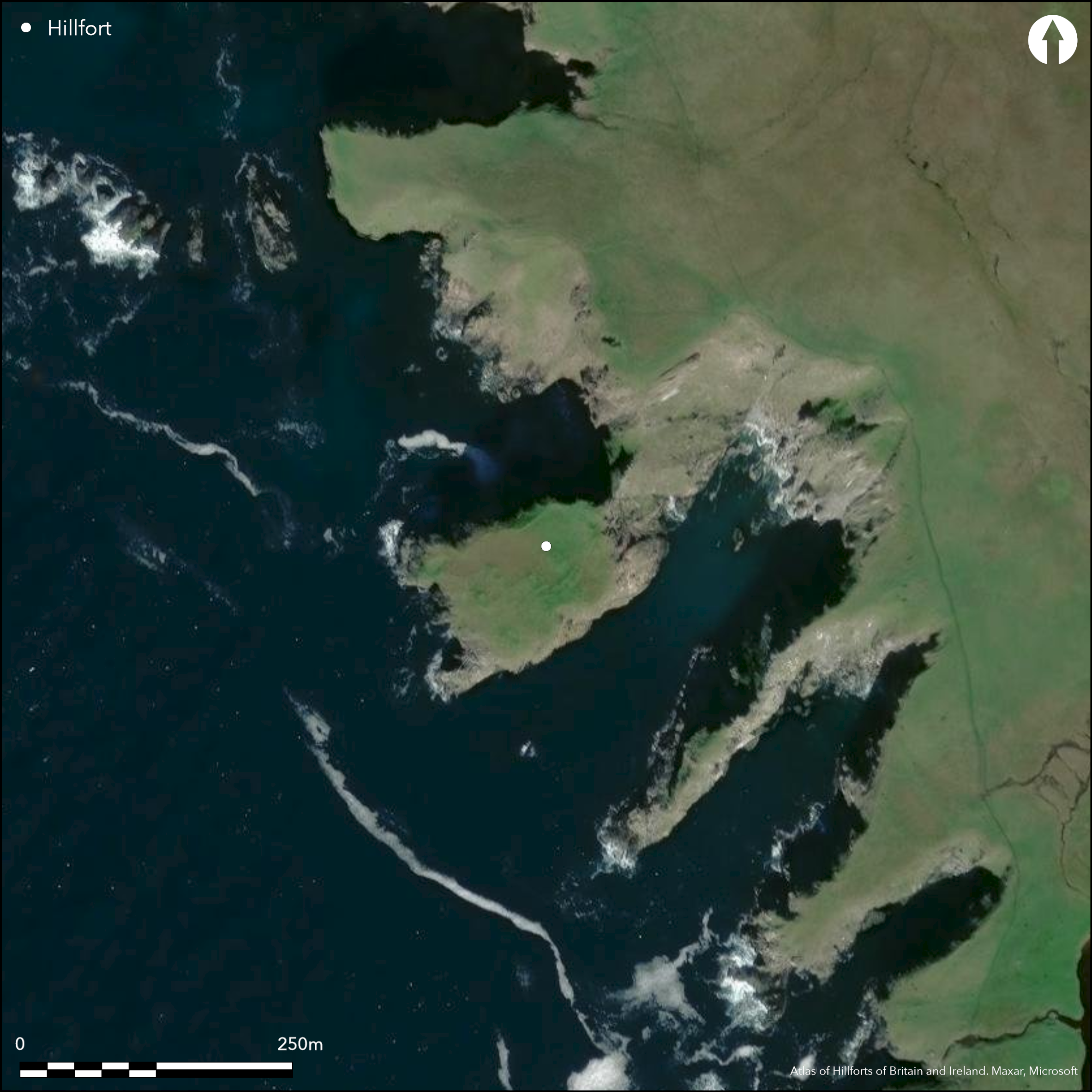
NGR: HU 4385 9135
X: 443850 Y: 1191350 (OSGB36)
This dramatic promontory enclosure, which is inaccessible to casual visitors, is situated on the W coast of Yell some way N of West Sandwick. Generally considered to be an early medieval monastic site (Lamb 1973; 1976), the presence of a grass-grown wall extending along the crest of the promontory overlooking the razor-backed neck linking it to the mainland on the NE is sufficient to include it amongst other promontory fortifications in the Northern Isles. From the wall on the crest, at some 40m OD, the surface of the promontory slopes steeply down towards the sea, before dropping over a cliff about 15m high at the SW end. The interior, which measures about 95m from NE to SW by up to 50m transversely (0.42ha) is thus screened from the neighbouring cliffs on the NE by the crest of the promontory. The footings of at least thirteen sub-rectangular buildings are disposed across the slope within the interior, six of them in two contiguous row that meet at right-angles to form an L-shape on plan. Though no entrance is visible, the narrow neck on the NE provides the only practical access.
Citizen Science: ✗
Reliability of Data: Confirmed
Reliability of Interpretation: Confirmed
X: -133694 Y: 8535300 (EPSG: 3857)
Longitude: -1.200998122137291 Latitude: 60.603305921874316 (EPSG:4326)
Country: Scotland
Current County or Unitary Authority: Shetland Islands
Historic County: Shetland
Current Parish/Community/Council/Townland: Yell
None
| Extant | ✓ |
| Cropmark | ✗ |
| Likely Destroyed | ✗ |
None
| Woodland | ✗ |
| Commercial Forestry Plantation | ✗ |
| Parkland | ✗ |
| Pasture (Grazing) | ✓ |
| Arable | ✗ |
| Scrub/Bracken | ✗ |
| Bare Outcrop | ✗ |
| Heather/Moorland | ✓ |
| Heath | ✗ |
| Built-up | ✗ |
| Coastal Grassland | ✗ |
| Other | ✗ |
None
| Contour Fort | ✗ |
| Partial Contour Fort | ✗ |
| Promontory Fort | ✓ |
| Hillslope Fort | ✗ |
| Level Terrain Fort | ✗ |
| Marsh Fort | ✗ |
| Multiple Enclosure Fort | ✗ |
| Hilltop | ✗ |
| Coastal Promontory | ✓ |
| Inland Promontory | ✗ |
| Valley Bottom | ✗ |
| Knoll/Hillock/Outcrop | ✗ |
| Ridge | ✗ |
| Cliff/Plateau-edge/Scarp | ✗ |
| Hillslope | ✗ |
| Lowland | ✗ |
| Spur | ✗ |
Dominant Topographic Feature: None
| North | ✗ |
| Northeast | ✗ |
| East | ✗ |
| Southeast | ✗ |
| South | ✗ |
| Southwest | ✗ |
| West | ✗ |
| Northwest | ✗ |
| Level | ✓ |
Altitude: 40.0m
N/A
By analogy this enclosure is usually considered to be a monastic settlement of early medieval date
Reliability: D - None
| Pre 1200BC | ✗ |
| 1200BC - 800BC | ✗ |
| 800BC - 400BC | ✗ |
| 400BC - AD50 | ✗ |
| AD50 - AD400 | ✗ |
| AD400 - AD 800 | ✗ |
| Post AD800 | ✗ |
| Unknown | ✓ |
| Pre Hillfort: | None |
| Post Hillfort: | None |
| Morphology/Earthwork/Typology: | By analogy likely to be an early medieval monastic site |
None
| 1st Identified Map Depiction (1878): | Annotated 'Picts Houses' on the 1st edition OS 6-inch map (Shetland 1881, sheet 15; Name Book, Shetland, No.13, p 216) |
| Other (1970): | Surveyed at 1:1250 by the OS (RCAHMS DC1914P & SC453287) |
| Other (1971): | Description and photographs from the neighbouring cliffs by Raymond Lamb (1973, 76-8, fig 1; photographs held by RCAHMS) |
| Other (1977): | Scheduled |
| Other (2000): | Shetland chapel-sites survey 1999-2000 (Copy held RCAHMS MS 1069/1 & 33; MS 725/281) |
| Other (2003): | Photographed by RCAHMS Aerial Survey Programme |
At least thirteen sub-rectangular buildings, half of them disposed in two contiguous rows forming an L-shape; the OS plan shows a possible fourteenth.
None
| None | ✓ |
| Spring | ✗ |
| Stream | ✗ |
| Pool | ✗ |
| Flush | ✗ |
| Well | ✗ |
| Other | ✗ |
None
| No Known Features | ✗ |
| Round Stone Structures | ✗ |
| Rectangular Stone Structures | ✓ |
| Curvilinear Platforms | ✗ |
| Other Roundhouse Evidence | ✗ |
| Pits | ✗ |
| Quarry Hollows | ✗ |
| Other | ✗ |
None
| No Known Excavation | ✓ |
| Pits | ✗ |
| Postholes | ✗ |
| Roundhouses | ✗ |
| Rectangular Structures | ✗ |
| Roads/Tracks | ✗ |
| Quarry Hollows | ✗ |
| Other | ✗ |
| Nothing Found | ✗ |
None
| No Known Geophysics | ✓ |
| Pits | ✗ |
| Roundhouses | ✗ |
| Rectangular Structures | ✗ |
| Roads/Tracks | ✗ |
| Quarry Hollows | ✗ |
| Other | ✗ |
| Nothing Found | ✗ |
None
| No Known Finds | ✓ |
| Pottery | ✗ |
| Metal | ✗ |
| Metalworking | ✗ |
| Human Bones | ✗ |
| Animal Bones | ✗ |
| Lithics | ✗ |
| Environmental | ✗ |
| Other | ✗ |
None
| APs Not Checked | ✗ |
| None | ✗ |
| Roundhouses | ✗ |
| Rectangular Structures | ✓ |
| Pits | ✗ |
| Postholes | ✗ |
| Roads/Tracks | ✗ |
| Other | ✗ |
Presumably accessed across the narrow neck on the NE
| 0: | None |
| 2: | Presumably accessed across the narrow neck on the NE |
Guard Chambers: ✗
Chevaux de Frise: ✗
Single wall extends around the lip of the promontory above the neck
| Area 1: | 0.42ha. |
| Total: | 0.42ha. |
Total Footprint Area: Noneha.
None
| ✗ | None |
| ✗ | None |
| NE Quadrant: | 1 |
| SE Quadrant: | 0 |
| SW Quadrant: | 0 |
| NW Quadrant: | 0 |
| Total: | 1 |
| Partial Univallate | ✓ |
| Univallate | ✗ |
| Partial Bivallate | ✗ |
| Bivallate | ✗ |
| Partial Multivallate | ✗ |
| Multivallate | ✗ |
| Unknown | ✗ |
| Partial Univallate | ✗ |
| Univallate | ✗ |
| Partial Bivallate | ✗ |
| Bivallate | ✗ |
| Partial Multivallate | ✗ |
| Multivallate | ✗ |
Grass-grown rubble
| None | ✗ |
| Earthen Bank | ✗ |
| Stone Wall | ✗ |
| Rubble | ✓ |
| Wall-walk | ✗ |
| Evidence of Timber | ✗ |
| Vitrification | ✗ |
| Other Burning | ✗ |
| Palisade | ✗ |
| Counter Scarp Bank | ✗ |
| Berm | ✗ |
| Unfinished | ✗ |
| Other | ✗ |
None
| None | ✗ |
| Earthen Bank | ✗ |
| Stone Wall | ✗ |
| Murus Duplex | ✗ |
| Timber-framed | ✗ |
| Timber-laced | ✗ |
| Vitrification | ✗ |
| Other Burning | ✗ |
| Palisade | ✗ |
| Counter Scarp Bank | ✗ |
| Berm | ✗ |
| Unfinished | ✗ |
| No Known Excavation | ✓ |
| Other | ✗ |
| ✗ | None |
| ✗ | None |
Number of Ditches: None
| ✗ | None |
Lamb, R G (1973) 'Coastal settlements of the north'. Scot Archaeol Forum 5 (1973), 76-98
Lamb, R G (1976) 'The Burri Stacks of Culswick, Shetland, and other paired stack-settlements'. Proc Soc Antiq Scot 107 (1975-6), 144-54
Name Book, Ordnance Survey Object Name Books (6 inch and 1/2500 scale); available https://www.scotlandsplaces.gov.uk/
Atlas of Hillforts:
Wikidata:
This work is licensed under CC BY-SA 4.0![]()
![]()
![]() and should be cited as:
and should be cited as:
Lock, Gary and Ralston, Ian. 2024. Atlas of Hillforts of Britain and Ireland. Available at: https://hillforts.arch.ox.ac.uk
Document Version 1.1