Satellite Imagery
Satellite Imagery
HER: Shetland Amenity Trust 2010 (None)
NMR: HU 55 NW 2 (1293)
SM: 5368
NGR: HU 5081 5813
X: 450810 Y: 1158130 (OSGB36)
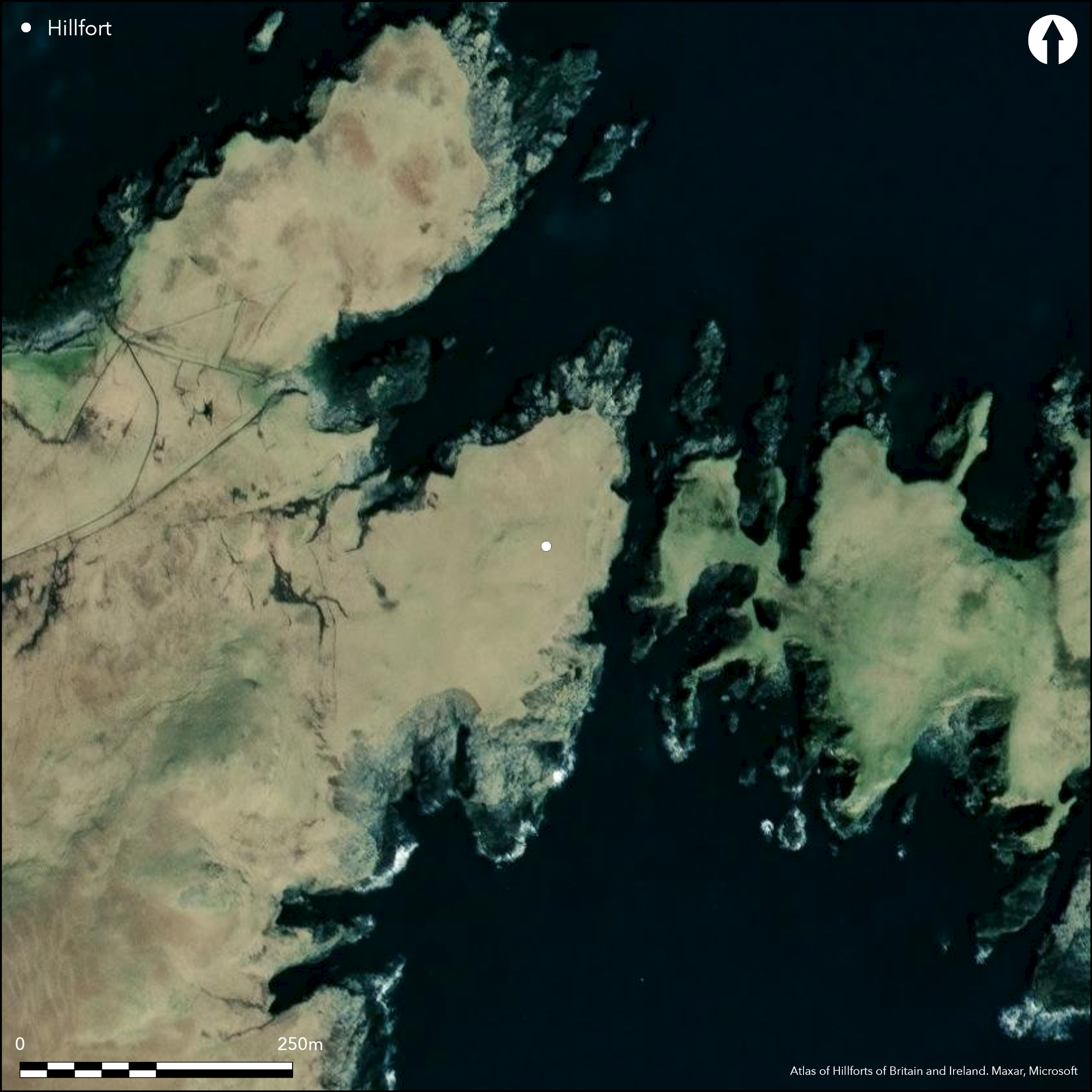
The defences of this probable fort are amongst the most extraordinary to have been recorded in Shetland, and escaped record until discovered by an OS surveyor in 1968. They comprise a belt of three ramparts reduced to banks about 3m thick and from 0.5m to 1m in height, and, rather than ditches, they are separated by shallow quarry scoops about 4.5m in breadth. The ramparts form a shallow arc that now backs onto the edge of a cliff some 10m high, and apparently mark the landward end of a promontory fort that once extended out onto Hog Island, from which it is now separated from by a chasm 18m wide. An entrance lies midway along the arc, piercing all three ramparts, and a plan drawn up by Raymond Lamb shows a series of large boulders set to either side of the gap through the middle rampart, and another two on the cliff-edge in the gap in the inner rampart (1980, 45, fig 15). Projecting the axis of this entrance across the geo to the island, Lamb observed another pair of large boulders set in the leading edge of the remains of a ruined wall extending along the cliff-edge at the W end of the island, though the OS surveyor was of the opinion that this was not part of the fortifications. At face value, it appears that the island was once linked to the mainland by a neck some 35m wide, and essentially represents the interior of a large promontory fort, though whether it really extended the full length of the island, which measures some 230m in length, or whether there was a barrier set at the next narrow neck to the E is unclear. The consequences for the size of the fort are extreme, for while the W end of the island measures no more than 65m from NNE to SSW by 30m transversely (0.13ha), eastwards beyond this neck, now 10m wide, it expands out to between 170m and 60m in breadth, representing an overall area of about 2ha. The OS surveyor crossed over to the island and the only feature he recorded was a roughly rectangular arrangement of seven granite boulders on the summit (RCAHMS Canmore 1292); this is named Egils House on the 1st edition OS 6-inch map (Shetland 1880, sheet 44; Name Book, Shetland, No.5, p 53), though the name has perhaps been transposed from a drystone rectangular pen or building visible on satellite imagery a little further ESE (HU 5103 5807). This stucture measures about 5.5m from NW to SE by 4m transversely overall, and has an entrance in its SE end.
Citizen Science: ✗
Reliability of Data: Confirmed
Reliability of Interpretation: Confirmed
X: -120488 Y: 8467791 (EPSG: 3857)
Longitude: -1.0823647866280113 Latitude: 60.30425698908696 (EPSG:4326)
Country: Scotland
Current County or Unitary Authority: Shetland Islands
Historic County: Shetland
Current Parish/Community/Council/Townland: Nesting
None
| Extant | ✓ |
| Cropmark | ✗ |
| Likely Destroyed | ✓ |
None
| Woodland | ✗ |
| Commercial Forestry Plantation | ✗ |
| Parkland | ✗ |
| Pasture (Grazing) | ✗ |
| Arable | ✗ |
| Scrub/Bracken | ✗ |
| Bare Outcrop | ✗ |
| Heather/Moorland | ✗ |
| Heath | ✗ |
| Built-up | ✗ |
| Coastal Grassland | ✓ |
| Other | ✗ |
None
| Contour Fort | ✗ |
| Partial Contour Fort | ✗ |
| Promontory Fort | ✓ |
| Hillslope Fort | ✗ |
| Level Terrain Fort | ✗ |
| Marsh Fort | ✗ |
| Multiple Enclosure Fort | ✗ |
| Hilltop | ✗ |
| Coastal Promontory | ✓ |
| Inland Promontory | ✗ |
| Valley Bottom | ✗ |
| Knoll/Hillock/Outcrop | ✗ |
| Ridge | ✗ |
| Cliff/Plateau-edge/Scarp | ✗ |
| Hillslope | ✗ |
| Lowland | ✗ |
| Spur | ✗ |
Dominant Topographic Feature: None
| North | ✗ |
| Northeast | ✗ |
| East | ✗ |
| Southeast | ✗ |
| South | ✗ |
| Southwest | ✗ |
| West | ✗ |
| Northwest | ✗ |
| Level | ✓ |
Altitude: 20.0m
N/A
In the absence of excavation, there are neither stratified artefacts nor radiocarbon dates to provide a chronology for the defences.
Reliability: D - None
| Pre 1200BC | ✗ |
| 1200BC - 800BC | ✗ |
| 800BC - 400BC | ✗ |
| 400BC - AD50 | ✗ |
| AD50 - AD400 | ✗ |
| AD400 - AD 800 | ✗ |
| Post AD800 | ✗ |
| Unknown | ✓ |
| Pre Hillfort: | None |
| Post Hillfort: | Heavily eroded by the sea; the rectangular structure at the E end is presumably of later date |
While Raymond Lamb was unable to access the island, the OS surveyor managed to cross over to record Egils House, and since he found no trace of any further ramparts confining the enclosed area to the W end of the island, de facto the fort extends to the whole island.
| 1st Identified Map Depiction (1968): | Description by the OS |
| Earthwork Survey (1970): | Plan and description by Raymond Lamb (1980, 45 fig15, 83-4; RCAHMS SHD 106/1) |
| Other (1992): | Scheduled |
Assuming that the fort is represented by the entire land area of Hog Island, what appears to be a rectangular stone-walled pen towards its E end, named Egils House on the 1st edition OS 6-inch map (Shetland 1880, sheet 44), lies within its interior.
None
| None | ✓ |
| Spring | ✗ |
| Stream | ✗ |
| Pool | ✗ |
| Flush | ✗ |
| Well | ✗ |
| Other | ✗ |
Probably of relatively recent date
| No Known Features | ✗ |
| Round Stone Structures | ✗ |
| Rectangular Stone Structures | ✓ |
| Curvilinear Platforms | ✗ |
| Other Roundhouse Evidence | ✗ |
| Pits | ✗ |
| Quarry Hollows | ✗ |
| Other | ✗ |
None
| No Known Excavation | ✓ |
| Pits | ✗ |
| Postholes | ✗ |
| Roundhouses | ✗ |
| Rectangular Structures | ✗ |
| Roads/Tracks | ✗ |
| Quarry Hollows | ✗ |
| Other | ✗ |
| Nothing Found | ✗ |
None
| No Known Geophysics | ✓ |
| Pits | ✗ |
| Roundhouses | ✗ |
| Rectangular Structures | ✗ |
| Roads/Tracks | ✗ |
| Quarry Hollows | ✗ |
| Other | ✗ |
| Nothing Found | ✗ |
None
| No Known Finds | ✓ |
| Pottery | ✗ |
| Metal | ✗ |
| Metalworking | ✗ |
| Human Bones | ✗ |
| Animal Bones | ✗ |
| Lithics | ✗ |
| Environmental | ✗ |
| Other | ✗ |
Probably of relatively recent date
| APs Not Checked | ✗ |
| None | ✗ |
| Roundhouses | ✗ |
| Rectangular Structures | ✓ |
| Pits | ✗ |
| Postholes | ✗ |
| Roads/Tracks | ✗ |
| Other | ✗ |
See main summary
| 1: | None |
| 2: | None |
Guard Chambers: ✗
Chevaux de Frise: ✗
| 1. Simple Gap (West): | Piercing all the lines and now opening straight onto the cliff-edge at its inner end |
At least three ramparts cutting off what must have been a promontory, but is now an island
| Area 1: | 2.0ha. |
| Total: | 2.0ha. |
Total Footprint Area: Noneha.
None
| ✗ | None |
| ✗ | None |
| NE Quadrant: | 0 |
| SE Quadrant: | 0 |
| SW Quadrant: | 0 |
| NW Quadrant: | 3 |
| Total: | 3 |
| Partial Univallate | ✗ |
| Univallate | ✗ |
| Partial Bivallate | ✗ |
| Bivallate | ✗ |
| Partial Multivallate | ✓ |
| Multivallate | ✗ |
| Unknown | ✗ |
| Partial Univallate | ✗ |
| Univallate | ✗ |
| Partial Bivallate | ✗ |
| Bivallate | ✗ |
| Partial Multivallate | ✗ |
| Multivallate | ✗ |
None
| None | ✗ |
| Earthen Bank | ✓ |
| Stone Wall | ✗ |
| Rubble | ✗ |
| Wall-walk | ✗ |
| Evidence of Timber | ✗ |
| Vitrification | ✗ |
| Other Burning | ✗ |
| Palisade | ✗ |
| Counter Scarp Bank | ✗ |
| Berm | ✗ |
| Unfinished | ✗ |
| Other | ✗ |
None
| None | ✗ |
| Earthen Bank | ✗ |
| Stone Wall | ✗ |
| Murus Duplex | ✗ |
| Timber-framed | ✗ |
| Timber-laced | ✗ |
| Vitrification | ✗ |
| Other Burning | ✗ |
| Palisade | ✗ |
| Counter Scarp Bank | ✗ |
| Berm | ✗ |
| Unfinished | ✗ |
| No Known Excavation | ✓ |
| Other | ✗ |
| ✗ | None |
| ✓ | Shallow scrapes |
Number of Ditches: 2
| ✗ | None |
Lamb, R G (1980) Iron Age promontory forts in the Northern Isles. Brit Archaeol Rep, British Ser 79. BAR: Oxford
Name Book, Ordnance Survey Object Name Books (6 inch and 1/2500 scale); available https://www.scotlandsplaces.gov.uk/
Atlas of Hillforts:
Wikidata:
This work is licensed under CC BY-SA 4.0![]()
![]()
![]() and should be cited as:
and should be cited as:
Lock, Gary and Ralston, Ian. 2024. Atlas of Hillforts of Britain and Ireland. Available at: https://hillforts.arch.ox.ac.uk
Document Version 1.1