Satellite Imagery
Satellite Imagery
HER: Highland HER MHG8226 (None)
NMR: NH 65 SE 1 (13572)
SM: 4740
NGR: NH 6963 5358
X: 269634 Y: 853581 (OSGB36)
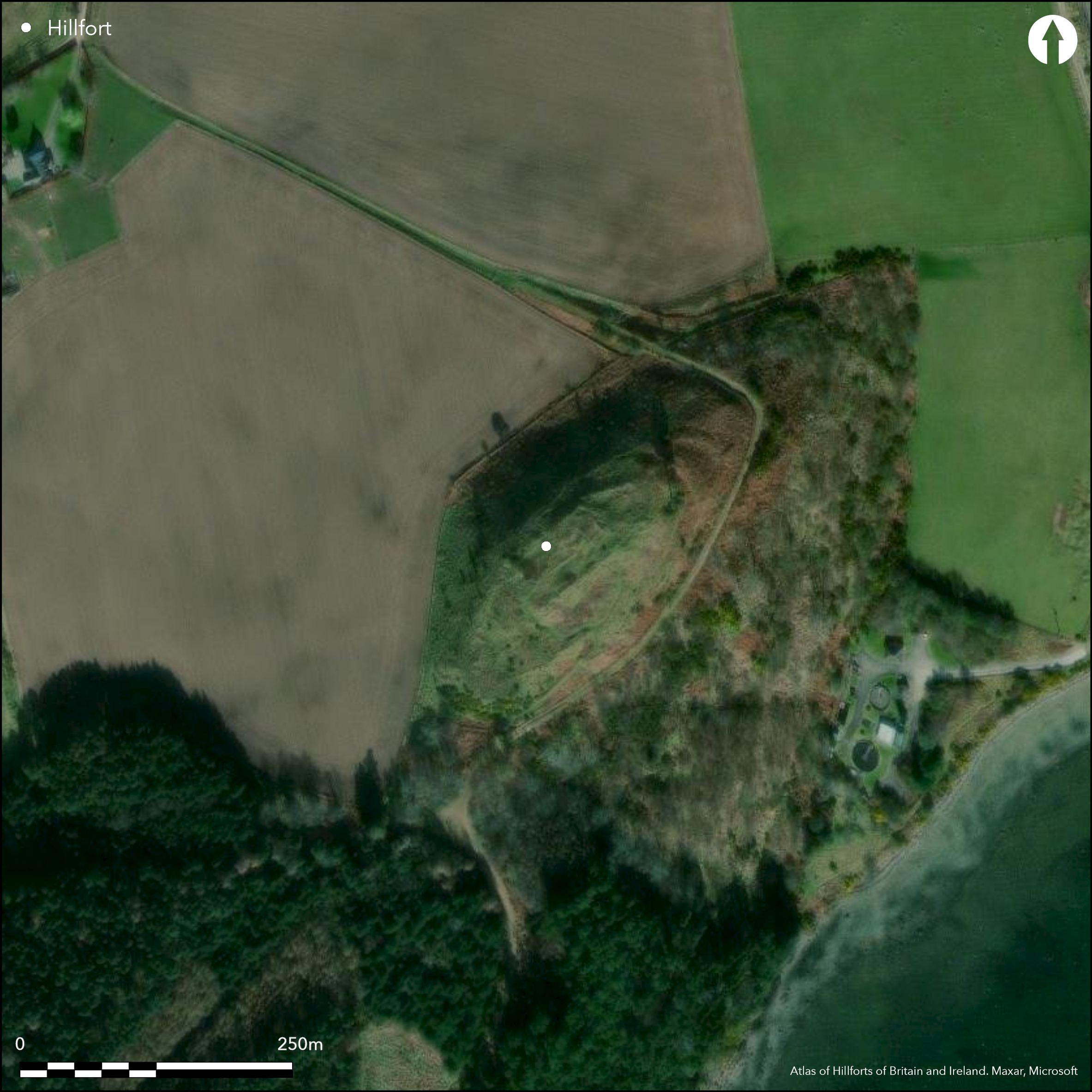
The remains of Ormond Castle may stand within the remains of an earlier fort enclosing the whole of the summit of Ormond Hill, which forms the low NE spur of Wood-hill. The margin of the summit area all round the hill is defined by a pronounced lip, from which the ground falls away steeply on all sides, along the SE flank some 60m to the W shore of the Moray Firth, but elsewhere between 5m on the SW to 20m on the N. This lip probably marks the line of the rampart of the fort, though it has been roughly adopted by walls enclosing outer wards of the castle, the core of which is rectangular on plan and lies eccentrically across the centre of the fort. Thus defined, the fort measures about 130m from NE to SW by 45m transversely (0.45ha), and at the NE end the rampart was accompanied by an external ditch with a counterscarp bank, while a little further down the slope another arc of ditch with an external bank can be seen; the inner of these can be traced as a terrace some way along the NW and SE flanks. If this is indeed an earlier fort, no structures relating to its occupation are visible beneath the ruins of the later castle and the position of the entrance is unknown, though a track obliquely mounts the SE flank from saddle on the SW.
Citizen Science: ✓
Reliability of Data: Confirmed
Reliability of Interpretation: Confirmed
X: -465349 Y: 7874112 (EPSG: 3857)
Longitude: -4.180302492257882 Latitude: 57.55355365687946 (EPSG:4326)
Country: Scotland
Current County or Unitary Authority: Highland
Historic County: Ross-shire
Current Parish/Community/Council/Townland: Avoch
None
| Extant | ✓ |
| Cropmark | ✗ |
| Likely Destroyed | ✗ |
Having previously been under trees, the hillock upon which the castle stands has been cleared
| Woodland | ✗ |
| Commercial Forestry Plantation | ✗ |
| Parkland | ✗ |
| Pasture (Grazing) | ✗ |
| Arable | ✗ |
| Scrub/Bracken | ✓ |
| Bare Outcrop | ✗ |
| Heather/Moorland | ✓ |
| Heath | ✗ |
| Built-up | ✗ |
| Coastal Grassland | ✗ |
| Other | ✗ |
None
| Contour Fort | ✓ |
| Partial Contour Fort | ✗ |
| Promontory Fort | ✗ |
| Hillslope Fort | ✗ |
| Level Terrain Fort | ✗ |
| Marsh Fort | ✗ |
| Multiple Enclosure Fort | ✗ |
| Hilltop | ✗ |
| Coastal Promontory | ✗ |
| Inland Promontory | ✗ |
| Valley Bottom | ✗ |
| Knoll/Hillock/Outcrop | ✓ |
| Ridge | ✗ |
| Cliff/Plateau-edge/Scarp | ✗ |
| Hillslope | ✗ |
| Lowland | ✗ |
| Spur | ✗ |
Dominant Topographic Feature: None
| North | ✗ |
| Northeast | ✗ |
| East | ✗ |
| Southeast | ✗ |
| South | ✗ |
| Southwest | ✗ |
| West | ✗ |
| Northwest | ✗ |
| Level | ✓ |
Altitude: 76.0m
N/A
In the absence of excavation, there are neither stratified artefacts nor radiocarbon dates to provide a chronology for the defences
Reliability: D - None
| Pre 1200BC | ✗ |
| 1200BC - 800BC | ✗ |
| 800BC - 400BC | ✗ |
| 400BC - AD50 | ✗ |
| AD50 - AD400 | ✗ |
| AD400 - AD 800 | ✗ |
| Post AD800 | ✗ |
| Unknown | ✓ |
| Pre Hillfort: | None |
| Post Hillfort: | Occupied by a medieval castle |
None
| 1st Identified Written Reference (1795): | Noted (Stat Acct, xv, , 638-9 ) |
| Other (1840): | Description of the earthworks (NSA, 14, Ross and Cromarty, 390) |
| 1st Identified Map Depiction (1871): | Named in Gothic type on the 1st edition OS 25-inch map (Ross and Cromarty, Ross-shire 1881, sheet 90.13) |
| Earthwork Survey (1883): | Plan and description by Angus Beaton (1885, 402, fig) |
| Other (1966): | Resurveyed at 1:2500 by the OS |
| Other (1970): | Visited by the OS |
| Other (1989): | Scheduled as a castle |
Occupied by the medieval castle
A well is marked on Angus Beaton's plan drawn up in 1883
| None | ✗ |
| Spring | ✗ |
| Stream | ✗ |
| Pool | ✗ |
| Flush | ✗ |
| Well | ✓ |
| Other | ✗ |
Castle and its buildings
| No Known Features | ✗ |
| Round Stone Structures | ✗ |
| Rectangular Stone Structures | ✗ |
| Curvilinear Platforms | ✗ |
| Other Roundhouse Evidence | ✗ |
| Pits | ✗ |
| Quarry Hollows | ✗ |
| Other | ✓ |
None
| No Known Excavation | ✓ |
| Pits | ✗ |
| Postholes | ✗ |
| Roundhouses | ✗ |
| Rectangular Structures | ✗ |
| Roads/Tracks | ✗ |
| Quarry Hollows | ✗ |
| Other | ✗ |
| Nothing Found | ✗ |
None
| No Known Geophysics | ✓ |
| Pits | ✗ |
| Roundhouses | ✗ |
| Rectangular Structures | ✗ |
| Roads/Tracks | ✗ |
| Quarry Hollows | ✗ |
| Other | ✗ |
| Nothing Found | ✗ |
None
| No Known Finds | ✓ |
| Pottery | ✗ |
| Metal | ✗ |
| Metalworking | ✗ |
| Human Bones | ✗ |
| Animal Bones | ✗ |
| Lithics | ✗ |
| Environmental | ✗ |
| Other | ✗ |
None
| APs Not Checked | ✗ |
| None | ✓ |
| Roundhouses | ✗ |
| Rectangular Structures | ✗ |
| Pits | ✗ |
| Postholes | ✗ |
| Roads/Tracks | ✗ |
| Other | ✗ |
See main summary
| 0: | None |
| 2: | Not known |
Guard Chambers: ✗
Chevaux de Frise: ✗
Single rampart, but accompanied by and external ditch and a counterscarp bank at the NE end, where there is also an outer arc of ditch with an external bank.
| Area 1: | 0.45ha. |
| Total: | 0.45ha. |
Total Footprint Area: Noneha.
None
| ✗ | None |
| ✓ | None |
| NE Quadrant: | 2 |
| SE Quadrant: | 1 |
| SW Quadrant: | 1 |
| NW Quadrant: | 1 |
| Total: | 2 |
| Partial Univallate | ✓ |
| Univallate | ✗ |
| Partial Bivallate | ✓ |
| Bivallate | ✗ |
| Partial Multivallate | ✗ |
| Multivallate | ✗ |
| Unknown | ✗ |
| Partial Univallate | ✗ |
| Univallate | ✗ |
| Partial Bivallate | ✗ |
| Bivallate | ✗ |
| Partial Multivallate | ✗ |
| Multivallate | ✗ |
Grass-grown rampart
| None | ✗ |
| Earthen Bank | ✓ |
| Stone Wall | ✗ |
| Rubble | ✗ |
| Wall-walk | ✗ |
| Evidence of Timber | ✗ |
| Vitrification | ✗ |
| Other Burning | ✗ |
| Palisade | ✗ |
| Counter Scarp Bank | ✓ |
| Berm | ✗ |
| Unfinished | ✗ |
| Other | ✗ |
None
| None | ✗ |
| Earthen Bank | ✗ |
| Stone Wall | ✗ |
| Murus Duplex | ✗ |
| Timber-framed | ✗ |
| Timber-laced | ✗ |
| Vitrification | ✗ |
| Other Burning | ✗ |
| Palisade | ✗ |
| Counter Scarp Bank | ✗ |
| Berm | ✗ |
| Unfinished | ✗ |
| No Known Excavation | ✓ |
| Other | ✗ |
| ✗ | None |
| ✓ | Visible only at one end |
Number of Ditches: 2
| ✗ | None |
Beaton, A J (1885) 'Notes on Ormond or Avoch Castle, in the Black Isle, Ross-shire, with a plan and section; and notice with drawing of bronze celts found in its vicinity'. Proc Soc Antiq Scot 19 (1884-5), 400-4
NSA (1834-1845) The new statistical account of Scotland by the ministers of the respective parishes under the superintendence of a committee of the society for the benefit of the sons and daughters of the clergy.
Stat Acct (date) Statistical Account of Scotland: Drawn up from the Communications of the Ministers of the Different Parishes (Sinclair, J ed), 1791-99
Atlas of Hillforts:
Wikidata:
This work is licensed under CC BY-SA 4.0![]()
![]()
![]() and should be cited as:
and should be cited as:
Lock, Gary and Ralston, Ian. 2024. Atlas of Hillforts of Britain and Ireland. Available at: https://hillforts.arch.ox.ac.uk
Document Version 1.1