LiDAR 1m DTM Hillshade
Satellite Imagery
LiDAR 1m DTM Hillshade
Satellite Imagery
Scroll left/right to view further images.
HER: Stirling 771.01 (None)
NMR: NS 79 SE 6 (46245)
SM: 90291
NGR: NS 7901 9407
X: 279010 Y: 694070 (OSGB36)
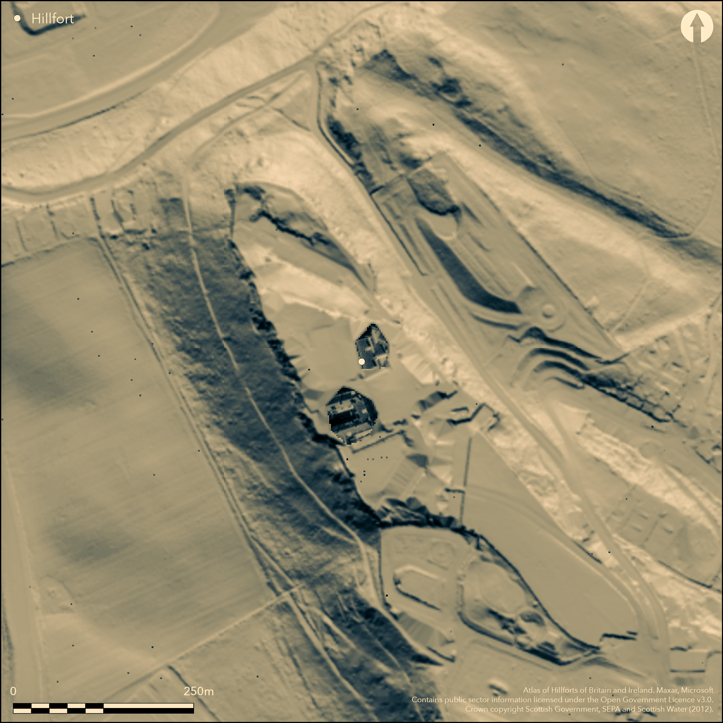
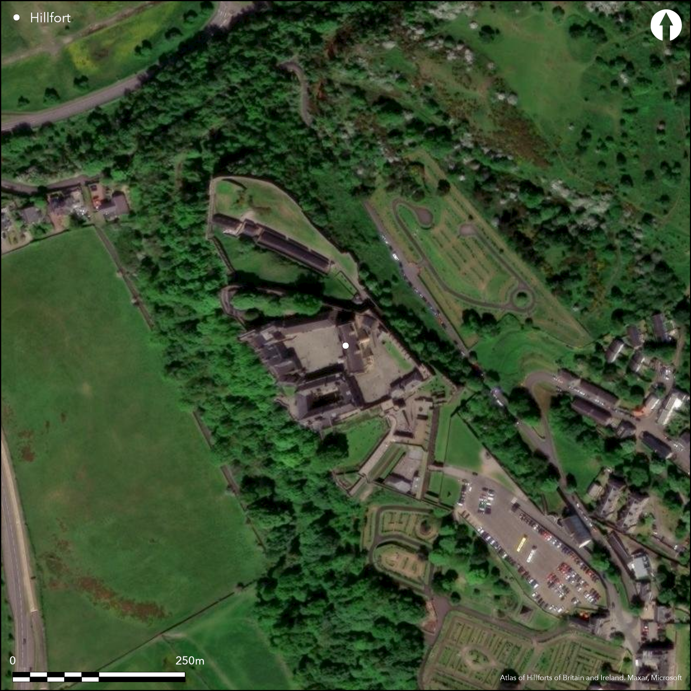
Stirling Castle occupies a commanding vantage point in the middle of the Forth Valley and is assumed to have been an early medieval caput, though no trace of earlier fortifications or occupation have been discovered beneath the castle itself. Angus Graham correlated Stirling Rock with urbs Giudi mentioned by Bede (1959), and this identification has been pursued more recently by Leslie Alcock (1981). Though the correlation is not necessarily universally accepted, in all probability Stirling Rock is the site of an early medieval fortification, and, like the Castle Rock in Edinburgh, is likely to have been occupied much earlier.
Citizen Science: ✗
Reliability of Data: Unconfirmed
Reliability of Interpretation: Unconfirmed
X: -439476 Y: 7583147 (EPSG: 3857)
Longitude: -3.947878131387898 Latitude: 56.124031729910605 (EPSG:4326)
Country: Scotland
Current County or Unitary Authority: Stirling
Historic County: Stirlingshire
Current Parish/Community/Council/Townland: Stirlingshire
None
Condition:| Extant | ✗ |
| Cropmark | ✗ |
| Likely Destroyed | ✓ |
None
Current Use:| Woodland | ✗ |
| Commercial Forestry Plantation | ✗ |
| Parkland | ✗ |
| Pasture (Grazing) | ✗ |
| Arable | ✗ |
| Scrub/Bracken | ✗ |
| Bare Outcrop | ✗ |
| Heather/Moorland | ✗ |
| Heath | ✗ |
| Built-up | ✓ |
| Coastal Grassland | ✗ |
| Other | ✗ |
Unknown character on the summit of the crags
Type:| Contour Fort | ✗ |
| Partial Contour Fort | ✗ |
| Promontory Fort | ✗ |
| Hillslope Fort | ✗ |
| Level Terrain Fort | ✗ |
| Marsh Fort | ✗ |
| Multiple Enclosure Fort | ✗ |
| Hilltop | ✓ |
| Coastal Promontory | ✗ |
| Inland Promontory | ✗ |
| Valley Bottom | ✗ |
| Knoll/Hillock/Outcrop | ✗ |
| Ridge | ✗ |
| Cliff/Plateau-edge/Scarp | ✗ |
| Hillslope | ✗ |
| Lowland | ✗ |
| Spur | ✗ |
Dominant Topographic Feature: None
| North | ✗ |
| Northeast | ✗ |
| East | ✗ |
| Southeast | ✗ |
| South | ✗ |
| Southwest | ✗ |
| West | ✗ |
| Northwest | ✗ |
| Level | ✓ |
Altitude: 68.0m
N/A
The existence of any earlier fortification on the summit area can only be established by excavation
Reliability: D - None
Principal Activity:| Pre 1200BC | ✗ |
| 1200BC - 800BC | ✗ |
| 800BC - 400BC | ✗ |
| 400BC - AD50 | ✗ |
| AD50 - AD400 | ✗ |
| AD400 - AD 800 | ✓ |
| Post AD800 | ✗ |
| Unknown | ✗ |
| Pre Hillfort: | None |
| Post Hillfort: | None |
| Other: | Documentary sources |
The medieval castle has been subject to numerous interventions (See RCAHMS Canmore and Stirling HER records)
| 1st Identified Written Reference (1959): | Angus Graham correlates Stirling with urbs Giudi (1959) |
| Other (1994): | Castle is Scheduled |
Unknown
None
Source:| None | ✓ |
| Spring | ✗ |
| Stream | ✗ |
| Pool | ✗ |
| Flush | ✗ |
| Well | ✗ |
| Other | ✗ |
None
Interior Features (Surface):| No Known Features | ✓ |
| Round Stone Structures | ✗ |
| Rectangular Stone Structures | ✗ |
| Curvilinear Platforms | ✗ |
| Other Roundhouse Evidence | ✗ |
| Pits | ✗ |
| Quarry Hollows | ✗ |
| Other | ✗ |
None
Interior Features (Excavation):| No Known Excavation | ✓ |
| Pits | ✗ |
| Postholes | ✗ |
| Roundhouses | ✗ |
| Rectangular Structures | ✗ |
| Roads/Tracks | ✗ |
| Quarry Hollows | ✗ |
| Other | ✗ |
| Nothing Found | ✗ |
None
Interior Features (Geophysics):| No Known Geophysics | ✓ |
| Pits | ✗ |
| Roundhouses | ✗ |
| Rectangular Structures | ✗ |
| Roads/Tracks | ✗ |
| Quarry Hollows | ✗ |
| Other | ✗ |
| Nothing Found | ✗ |
None
Interior (Finds):| No Known Finds | ✓ |
| Pottery | ✗ |
| Metal | ✗ |
| Metalworking | ✗ |
| Human Bones | ✗ |
| Animal Bones | ✗ |
| Lithics | ✗ |
| Environmental | ✗ |
| Other | ✗ |
NO APPARENT FEATURES
Interior Features (Aerial):| APs Not Checked | ✓ |
| None | ✗ |
| Roundhouses | ✗ |
| Rectangular Structures | ✗ |
| Pits | ✗ |
| Postholes | ✗ |
| Roads/Tracks | ✗ |
| Other | ✗ |
None known
Total Number of Breaks Through Ramparts:| 0: | None |
| 2: | Unknown |
Guard Chambers: ✗
Chevaux de Frise: ✗
Unknown
Enclosed Area:| Area 1: | Noneha. |
| Total: | Noneha. |
Total Footprint Area: Noneha.
None
Multi-period Enclosure System:| ✗ | None |
| ✗ | Unknown |
| NE Quadrant: | 0 |
| SE Quadrant: | 0 |
| SW Quadrant: | 0 |
| NW Quadrant: | 0 |
| Total: | 0 |
| Partial Univallate | ✗ |
| Univallate | ✗ |
| Partial Bivallate | ✗ |
| Bivallate | ✗ |
| Partial Multivallate | ✗ |
| Multivallate | ✗ |
| Unknown | ✓ |
| Partial Univallate | ✗ |
| Univallate | ✗ |
| Partial Bivallate | ✗ |
| Bivallate | ✗ |
| Partial Multivallate | ✗ |
| Multivallate | ✗ |
None
Enclosing Works (Surface):| None | ✓ |
| Earthen Bank | ✗ |
| Stone Wall | ✗ |
| Rubble | ✗ |
| Wall-walk | ✗ |
| Evidence of Timber | ✗ |
| Vitrification | ✗ |
| Other Burning | ✗ |
| Palisade | ✗ |
| Counter Scarp Bank | ✗ |
| Berm | ✗ |
| Unfinished | ✗ |
| Other | ✗ |
None
Enclosing Works (Excavation):| None | ✗ |
| Earthen Bank | ✗ |
| Stone Wall | ✗ |
| Murus Duplex | ✗ |
| Timber-framed | ✗ |
| Timber-laced | ✗ |
| Vitrification | ✗ |
| Other Burning | ✗ |
| Palisade | ✗ |
| Counter Scarp Bank | ✗ |
| Berm | ✗ |
| Unfinished | ✗ |
| No Known Excavation | ✓ |
| Other | ✗ |
| ✗ | None |
| ✗ | None |
Number of Ditches: None
Annex:| ✗ | None |
Alcock, L (1981) 'Early historic fortifications in Scotland'. 150-201 in Guilbert, G (ed) Hill-fort studies: essays for A H A Hogg. Leicester University Press: Leicester
Graham, A (1959) 'Giudi'. Antiquity 33 (1959), 63-5
This work is licensed under CC BY-SA 4.0![]()
![]()
![]() and should be cited as:
and should be cited as:
Lock, Gary and Ralston, Ian. 2024. Atlas of Hillforts of Britain and Ireland. Available at: https://hillforts.arch.ox.ac.uk
Document Version 1.1