
LiDAR 1m DTM Hillshade
Satellite Imagery
LiDAR 1m DTM Hillshade
Satellite Imagery
Scroll left/right to view further images.
HER: The West of Scotland Archaeology Service 66599 (None)
NMR: NS 32 NE 125 (311344)
SM: None
NGR: NS 3618 2805
X: 236184 Y: 628055 (OSGB36)
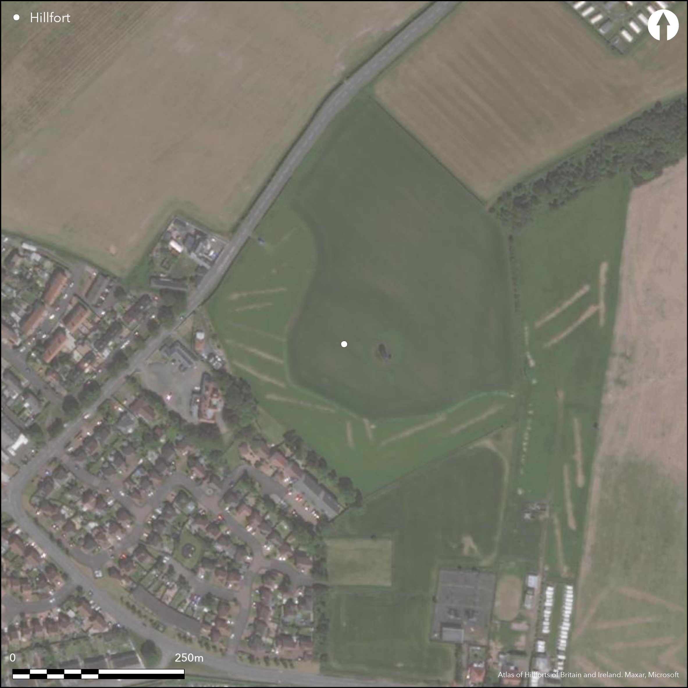
Cropmarks have revealed the site of a fort on the hillock that forms the W end of the low spur that provides an elevated position for the 18th century windmill above Monkton. The mill tower stands towards the E end of the fort, which is oval on plan and measures about 95m from E to W by 80m transversely (0.59ha) within a ditch between 5m and 6m in breadth. Allowing for the presence of an internal rampart, the defences enclosed about 0.45ha and were pierced by an entrance on the W. Apart from the mill tower, the only feature visible within the interior is a minor ditch no more than 2m in breadth, which lies about 10m within the main ditch around the W quarter.
Citizen Science: ✗
Reliability of Data: Confirmed
Reliability of Interpretation: Confirmed
X: -511659 Y: 7463197 (EPSG: 3857)
Longitude: -4.596306729880564 Latitude: 55.51872151078257 (EPSG:4326)
Country: Scotland
Current County or Unitary Authority: South Ayrshire
Historic County: Ayrshire
Current Parish/Community/Council/Townland: Monkton And Prestwick
None
| Extant | ✗ |
| Cropmark | ✓ |
| Likely Destroyed | ✗ |
None
| Woodland | ✗ |
| Commercial Forestry Plantation | ✗ |
| Parkland | ✗ |
| Pasture (Grazing) | ✗ |
| Arable | ✓ |
| Scrub/Bracken | ✗ |
| Bare Outcrop | ✗ |
| Heather/Moorland | ✗ |
| Heath | ✗ |
| Built-up | ✗ |
| Coastal Grassland | ✗ |
| Other | ✗ |
None
| Contour Fort | ✓ |
| Partial Contour Fort | ✗ |
| Promontory Fort | ✗ |
| Hillslope Fort | ✗ |
| Level Terrain Fort | ✗ |
| Marsh Fort | ✗ |
| Multiple Enclosure Fort | ✗ |
| Hilltop | ✗ |
| Coastal Promontory | ✗ |
| Inland Promontory | ✗ |
| Valley Bottom | ✗ |
| Knoll/Hillock/Outcrop | ✓ |
| Ridge | ✗ |
| Cliff/Plateau-edge/Scarp | ✗ |
| Hillslope | ✗ |
| Lowland | ✗ |
| Spur | ✓ |
Dominant Topographic Feature: None
| North | ✗ |
| Northeast | ✗ |
| East | ✗ |
| Southeast | ✗ |
| South | ✗ |
| Southwest | ✗ |
| West | ✗ |
| Northwest | ✗ |
| Level | ✓ |
Altitude: 38.0m
N/A
In the absence of excavation, there are neither stratified artefacts nor radiocarbon dates to provide a chronology for the perimeter
Reliability: D - None
| Pre 1200BC | ✗ |
| 1200BC - 800BC | ✗ |
| 800BC - 400BC | ✗ |
| 400BC - AD50 | ✗ |
| AD50 - AD400 | ✗ |
| AD400 - AD 800 | ✗ |
| Post AD800 | ✗ |
| Unknown | ✓ |
| Pre Hillfort: | None |
| Post Hillfort: | Overlain by the stump of an 18th century tower mill |
The stump of the windmill tower was Scheduled in 1981 (SM4340)
| 1st Identified Written Reference (2010): | Photographed by RCAHMS Aerial Survey Programme |
A lesser ditch can be seen within the interior, but otherwise the tower mill is the only feature
None
| None | ✓ |
| Spring | ✗ |
| Stream | ✗ |
| Pool | ✗ |
| Flush | ✗ |
| Well | ✗ |
| Other | ✗ |
None
| No Known Features | ✓ |
| Round Stone Structures | ✗ |
| Rectangular Stone Structures | ✗ |
| Curvilinear Platforms | ✗ |
| Other Roundhouse Evidence | ✗ |
| Pits | ✗ |
| Quarry Hollows | ✗ |
| Other | ✗ |
None
| No Known Excavation | ✓ |
| Pits | ✗ |
| Postholes | ✗ |
| Roundhouses | ✗ |
| Rectangular Structures | ✗ |
| Roads/Tracks | ✗ |
| Quarry Hollows | ✗ |
| Other | ✗ |
| Nothing Found | ✗ |
None
| No Known Geophysics | ✓ |
| Pits | ✗ |
| Roundhouses | ✗ |
| Rectangular Structures | ✗ |
| Roads/Tracks | ✗ |
| Quarry Hollows | ✗ |
| Other | ✗ |
| Nothing Found | ✗ |
None
| No Known Finds | ✓ |
| Pottery | ✗ |
| Metal | ✗ |
| Metalworking | ✗ |
| Human Bones | ✗ |
| Animal Bones | ✗ |
| Lithics | ✗ |
| Environmental | ✗ |
| Other | ✗ |
NO APPARENT FEATURES
| APs Not Checked | ✗ |
| None | ✓ |
| Roundhouses | ✗ |
| Rectangular Structures | ✗ |
| Pits | ✗ |
| Postholes | ✗ |
| Roads/Tracks | ✗ |
| Other | ✗ |
See main summary
| 1: | The whole circuit is ploughed flat |
| 2: | None |
Guard Chambers: ✗
Chevaux de Frise: ✗
| 1. Simple Gap (West): | Probable entrance |
A single broad ditch, presumably with an upcast rampart, though a lesser ditch can be seen within the interior on the W
| Area 1: | 0.45ha. |
| Total: | 0.45ha. |
Total Footprint Area: Noneha.
None
| ✗ | None |
| ✓ | Excludes the minor ditch within the interior |
| NE Quadrant: | 1 |
| SE Quadrant: | 1 |
| SW Quadrant: | 1 |
| NW Quadrant: | 1 |
| Total: | 1 |
| Partial Univallate | ✗ |
| Univallate | ✓ |
| Partial Bivallate | ✗ |
| Bivallate | ✗ |
| Partial Multivallate | ✗ |
| Multivallate | ✗ |
| Unknown | ✗ |
| Partial Univallate | ✗ |
| Univallate | ✗ |
| Partial Bivallate | ✗ |
| Bivallate | ✗ |
| Partial Multivallate | ✗ |
| Multivallate | ✗ |
None
| None | ✓ |
| Earthen Bank | ✗ |
| Stone Wall | ✗ |
| Rubble | ✗ |
| Wall-walk | ✗ |
| Evidence of Timber | ✗ |
| Vitrification | ✗ |
| Other Burning | ✗ |
| Palisade | ✗ |
| Counter Scarp Bank | ✗ |
| Berm | ✗ |
| Unfinished | ✗ |
| Other | ✗ |
None
| None | ✗ |
| Earthen Bank | ✗ |
| Stone Wall | ✗ |
| Murus Duplex | ✗ |
| Timber-framed | ✗ |
| Timber-laced | ✗ |
| Vitrification | ✗ |
| Other Burning | ✗ |
| Palisade | ✗ |
| Counter Scarp Bank | ✗ |
| Berm | ✗ |
| Unfinished | ✗ |
| No Known Excavation | ✓ |
| Other | ✗ |
| ✗ | None |
| ✓ | Excludes the minor ditch within the interior |
Number of Ditches: 1
| ✗ | None |
No related records
Atlas of Hillforts:
Wikidata:
This work is licensed under CC BY-SA 4.0![]()
![]()
![]() and should be cited as:
and should be cited as:
Lock, Gary and Ralston, Ian. 2024. Atlas of Hillforts of Britain and Ireland. Available at: https://hillforts.arch.ox.ac.uk
Document Version 1.1