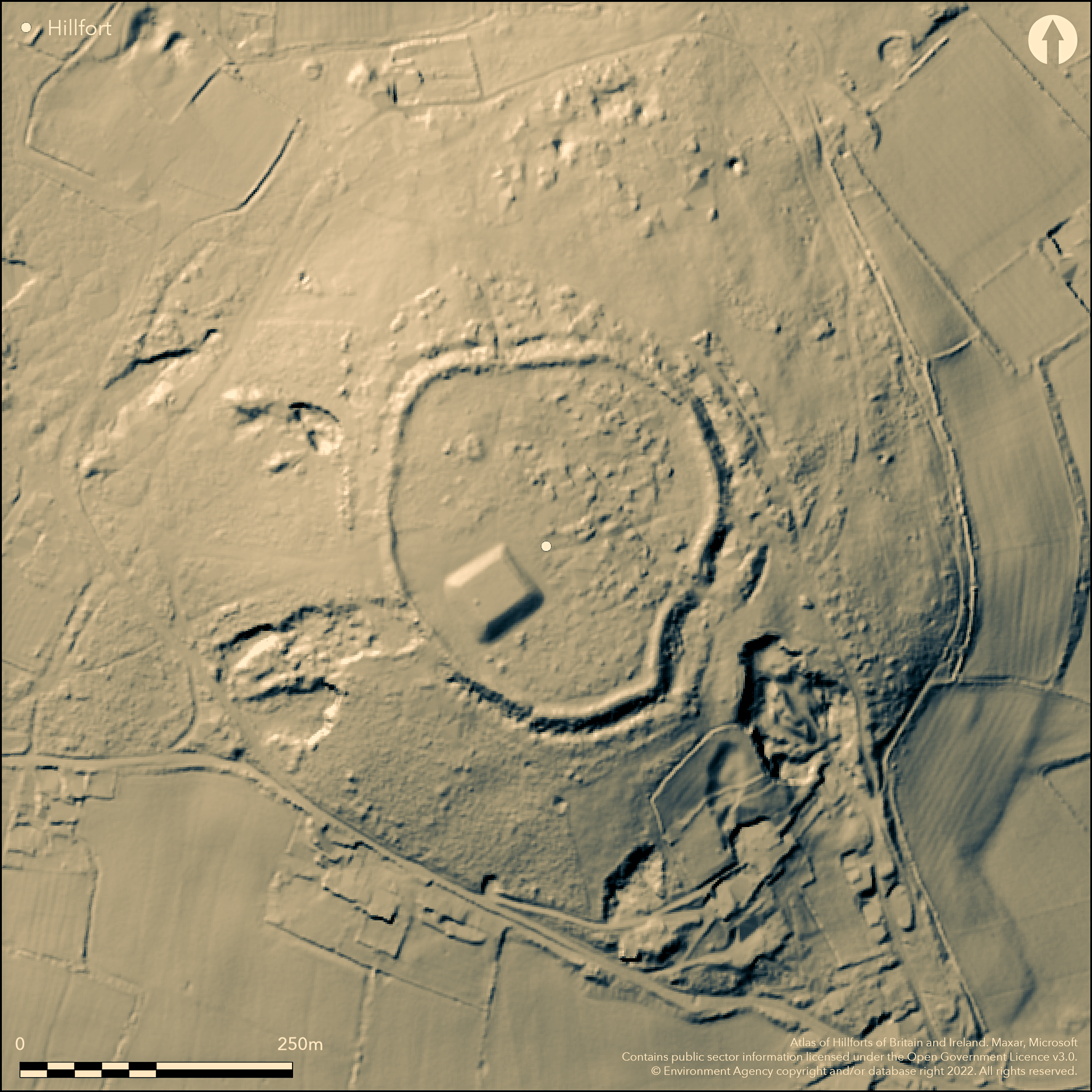
LiDAR 1m DTM Hillshade

Satellite Imagery
LiDAR 1m DTM Hillshade
Satellite Imagery
Scroll left/right to view further images.
HER: Clwyd Powys 100296 (None)
NMR: SJ 26 NW 2 (95090)
SM: FL011
NGR: SJ21116903
X: 321110 Y: 369030 (OSGB36)
Isolated and important, excavated, contour hillfort located on prominent rising ground of low limestone knoll at Rhosesmor above River Dee Estuary to E. Although mostly moderate surrounding slopes, steeper on E, site gives outstanding and commanding views in all directions. Sub-oval in shape measures c. 190m N-S by 130-170m, with internal area 2.7ha. Single bank and ditch with counterscarp around most of circuit, but second ditch and bank added on the NE near the entrance. Rescue excavation of c. fifth of interior by G.C. Guilbert/CPAT 1972-74 in advance of water storage facility. 21 radiocarbon dates (Horn forthcoming) show pre-rampart enclosure with roundhouses, Rampart A first constructed c. 800-540 cal. BC, refurbished c. 370 cal. BC, replaced by Rampart B c. 360 cal. BC.Three complex main interior phases of development identified, with the earliest settlement having a palisade. Regular layout pattern detected with four-post structures and evidence of a rectangular Neolithic building. Bronze Age cairns in interior. Substantial water storage facility constructed in interior 1970's, otherwise good condition. Rough pasture and gorse scrub in interior, banks and surrounds. Popular public access affects earthworks. On 1st Ed. OS map (1870).
Citizen Science: ✗
Reliability of Data: Confirmed
Reliability of Interpretation: Confirmed
X: -354309 Y: 7022391 (EPSG: 3857)
Longitude: -3.1828106729123666 Latitude: 53.212440431116285 (EPSG:4326)
Country: Wales
Current County or Unitary Authority: Flintshire
Historic County: Flintshire
Current Parish/Community/Council/Townland: Halkyn
Substantial water storage facility constructed in interior 1970's, otherwise good condition. Popular public access affects earthworks with path along rampart top.
| Extant | ✓ |
| Cropmark | ✗ |
| Likely Destroyed | ✗ |
Rough pasture and gorse scrub in interior, banks and surrounds. Water storage facility.
| Woodland | ✗ |
| Commercial Forestry Plantation | ✗ |
| Parkland | ✗ |
| Pasture (Grazing) | ✓ |
| Arable | ✗ |
| Scrub/Bracken | ✓ |
| Bare Outcrop | ✗ |
| Heather/Moorland | ✗ |
| Heath | ✗ |
| Built-up | ✓ |
| Coastal Grassland | ✗ |
| Other | ✓ |
Isolated contour hillfort located on prominent rising ground of low limestone knoll above River Dee Estuary to E. Although mostly moderate surrounding slopes, steeper on E, site gives outstanding and commanding views in all directions.
| Contour Fort | ✓ |
| Partial Contour Fort | ✗ |
| Promontory Fort | ✗ |
| Hillslope Fort | ✗ |
| Level Terrain Fort | ✗ |
| Marsh Fort | ✗ |
| Multiple Enclosure Fort | ✗ |
| Hilltop | ✗ |
| Coastal Promontory | ✗ |
| Inland Promontory | ✗ |
| Valley Bottom | ✗ |
| Knoll/Hillock/Outcrop | ✓ |
| Ridge | ✗ |
| Cliff/Plateau-edge/Scarp | ✗ |
| Hillslope | ✗ |
| Lowland | ✗ |
| Spur | ✗ |
Dominant Topographic Feature: Knoll
| North | ✗ |
| Northeast | ✗ |
| East | ✗ |
| Southeast | ✗ |
| South | ✗ |
| Southwest | ✗ |
| West | ✗ |
| Northwest | ✗ |
| Level | ✓ |
Altitude: 290.0m
N/A
A total of 21 C14 dates although of variable reliability (Horn forthcoming). Early Iron Age rampart constructed, possibly on line of Bronze Age palisade in 6th century BC. Evidence for Neolithic activity. Late Bronze Age sequence of 'stockaded camp' with roundhouses and palisade.
Reliability: A - High
| Pre 1200BC | ✗ |
| 1200BC - 800BC | ✗ |
| 800BC - 400BC | ✓ |
| 400BC - AD50 | ✗ |
| AD50 - AD400 | ✗ |
| AD400 - AD 800 | ✗ |
| Post AD800 | ✗ |
| Unknown | ✗ |
| Pre Hillfort: | None |
| Post Hillfort: | None |
| Artefactual: | Neolithic flints and pottery fragments |
| C14: | None |
On 1st Ed. OS map (1870). Rescue excavation of c. fifth of interior and sections of defences by G.C. Guilbert/CPAT 1972-74 in advance of water storage facility.
| 1st Identified Map Depiction (1870): | OS map. |
| Other (1977): | Visit by Hillfort Study Group |
| Other (2012): | Visited by Hillfort Study Group |
| Excavation (None): | G.C. Guilbert/CPAT. |
Evidence of undefended Neolithic rectangular building, postholes and flint and chert knives, scrapers, arrowheads blades and pottery fragments. Late Bronze Age sequence of stockade with roundhouses and palisade. Later regular layout pattern detected, with roundhouses (mostly facing E and SE) and four-post structures. Neolithic flint and chert knives, scrapers, arrowheads blades and pottery fragments.
Stream 0.7km outside fort.
| None | ✓ |
| Spring | ✗ |
| Stream | ✗ |
| Pool | ✗ |
| Flush | ✗ |
| Well | ✗ |
| Other | ✗ |
Two Bronze Age cairns, one overlain by rampart.
| No Known Features | ✗ |
| Round Stone Structures | ✗ |
| Rectangular Stone Structures | ✗ |
| Curvilinear Platforms | ✗ |
| Other Roundhouse Evidence | ✗ |
| Pits | ✗ |
| Quarry Hollows | ✗ |
| Other | ✓ |
Regular layout pattern detected with roundhouses (mostly facing E and SE), four-post structures and evidence of a rectangular undefended Neolithic building. Late Bronze Age sequence of stockade with roundhouses and palisade.
| No Known Excavation | ✗ |
| Pits | ✗ |
| Postholes | ✓ |
| Roundhouses | ✓ |
| Rectangular Structures | ✓ |
| Roads/Tracks | ✗ |
| Quarry Hollows | ✗ |
| Other | ✓ |
| Nothing Found | ✗ |
No details.
| No Known Geophysics | ✗ |
| Pits | ✗ |
| Roundhouses | ✗ |
| Rectangular Structures | ✗ |
| Roads/Tracks | ✗ |
| Quarry Hollows | ✗ |
| Other | ✓ |
| Nothing Found | ✗ |
Neolithic flint and chert knives, scrapers, arrowheads blades and pottery fragments.
| No Known Finds | ✗ |
| Pottery | ✓ |
| Metal | ✗ |
| Metalworking | ✗ |
| Human Bones | ✗ |
| Animal Bones | ✗ |
| Lithics | ✓ |
| Environmental | ✗ |
| Other | ✗ |
None
| APs Not Checked | ✓ |
| None | ✗ |
| Roundhouses | ✗ |
| Rectangular Structures | ✗ |
| Pits | ✗ |
| Postholes | ✗ |
| Roads/Tracks | ✗ |
| Other | ✗ |
Good inturned entrance on E. Gap on N modern. Blocked entrance on W.
| 3: | Gap on N modern. |
| 2: | None |
Guard Chambers: ✗
Chevaux de Frise: ✗
| 1. In-turned (East): | Good entrance. |
| 2. Blocked (West): | None |
Single bank and ditch around most of circuit, but second ditch and bank added on the NE near the entrance. Late Bronze Age sequence of 'stockaded camp' with palisade. 6th century BC box rampart, with upright timbers 0.6m-0.9m apart with gaps infilled with dry-stone walling and large orthostats.
| Area 1: | 2.7ha. |
| Total: | 2.7ha. |
Total Footprint Area: Noneha.
None
| ✓ | Three complex main interior phases of development, with the earliest settlement having a palisade. |
| ✓ | None |
| NE Quadrant: | 2 |
| SE Quadrant: | 1 |
| SW Quadrant: | 1 |
| NW Quadrant: | 1 |
| Total: | 2 |
| Partial Univallate | ✓ |
| Univallate | ✗ |
| Partial Bivallate | ✓ |
| Bivallate | ✗ |
| Partial Multivallate | ✗ |
| Multivallate | ✗ |
| Unknown | ✗ |
| Partial Univallate | ✗ |
| Univallate | ✗ |
| Partial Bivallate | ✗ |
| Bivallate | ✗ |
| Partial Multivallate | ✗ |
| Multivallate | ✗ |
Box rampart shows well.
| None | ✗ |
| Earthen Bank | ✓ |
| Stone Wall | ✗ |
| Rubble | ✓ |
| Wall-walk | ✗ |
| Evidence of Timber | ✗ |
| Vitrification | ✗ |
| Other Burning | ✗ |
| Palisade | ✗ |
| Counter Scarp Bank | ✓ |
| Berm | ✗ |
| Unfinished | ✗ |
| Other | ✗ |
Late Bronze Age sequence of 'stockaded camp' with roundhouses and palisade. 6th century BC box rampart, with upright timbers 0.6m-0.9m apart with gaps infilled with dry-stone walling and large orthostats.
| None | ✗ |
| Earthen Bank | ✗ |
| Stone Wall | ✓ |
| Murus Duplex | ✗ |
| Timber-framed | ✓ |
| Timber-laced | ✗ |
| Vitrification | ✗ |
| Other Burning | ✗ |
| Palisade | ✓ |
| Counter Scarp Bank | ✗ |
| Berm | ✗ |
| Unfinished | ✗ |
| No Known Excavation | ✗ |
| Other | ✗ |
| ✓ | Possible evidence of gang working. |
| ✓ | Single ditch around circuit, with second ditch to outer bank on E near entrance. |
Number of Ditches: 2
| ✗ | None |
Brown, I. 2009. Beacons in the landscape. The hillforts of England and Wales, Oxford: Windgather Press/Oxbow Books.
Burnham, H. 1995. A guide to ancient and historic Wales - Clwyd and Powys, London: HMSO, 56-8.
Guilbert, G.C. 1973. Moel y Gaer Rhosesmor, Curr Archaeol, 37, 38-44.
Guilbert, G. C. 1974. Moel y Gaer (SJ211691). Archaeol Wales 14, 14.
Guilbert, G. C. 1975. Moel y Gaer (SJ211691). Archaeol Wales 15, 33.
Graeme Guilbert. 1975. Moel y Gaer, 1973: an area excavation on the defences. Antiquity 49, 109-117.
Guilbert, G.C. 1975. Planned hillfort interiors, Proc Prehist Soc, 41, 203-21.
Guilbert, G.C., 1976. Moel y Gaer. Archaeol Wales 16, 23.
Guilbert, G.C. 1976. Moel y Gaer (Rhosesmor) 1972-1973 an area excavation in the interior, in ed D.W. Harding, Hillforts. Later prehistoric earthworks in Britain and Ireland, London: Academic Press, 303-17.
Guilbert, G.C., 1979. 'Moel y Gaer', Archaeology in Wales 19, 15.
Guilbert, G.C., 1981, 'Moel y Gaer', Archaeology in Wales 21, 23.
Horn, J. Forthcoming. The dating of hillforts in Britain and Ireland. Unpublished PhD thesis, University of Edinburgh.
Atlas of Hillforts:
Wikidata:
This work is licensed under CC BY-SA 4.0![]()
![]()
![]() and should be cited as:
and should be cited as:
Lock, Gary and Ralston, Ian. 2024. Atlas of Hillforts of Britain and Ireland. Available at: https://hillforts.arch.ox.ac.uk
Document Version 1.1