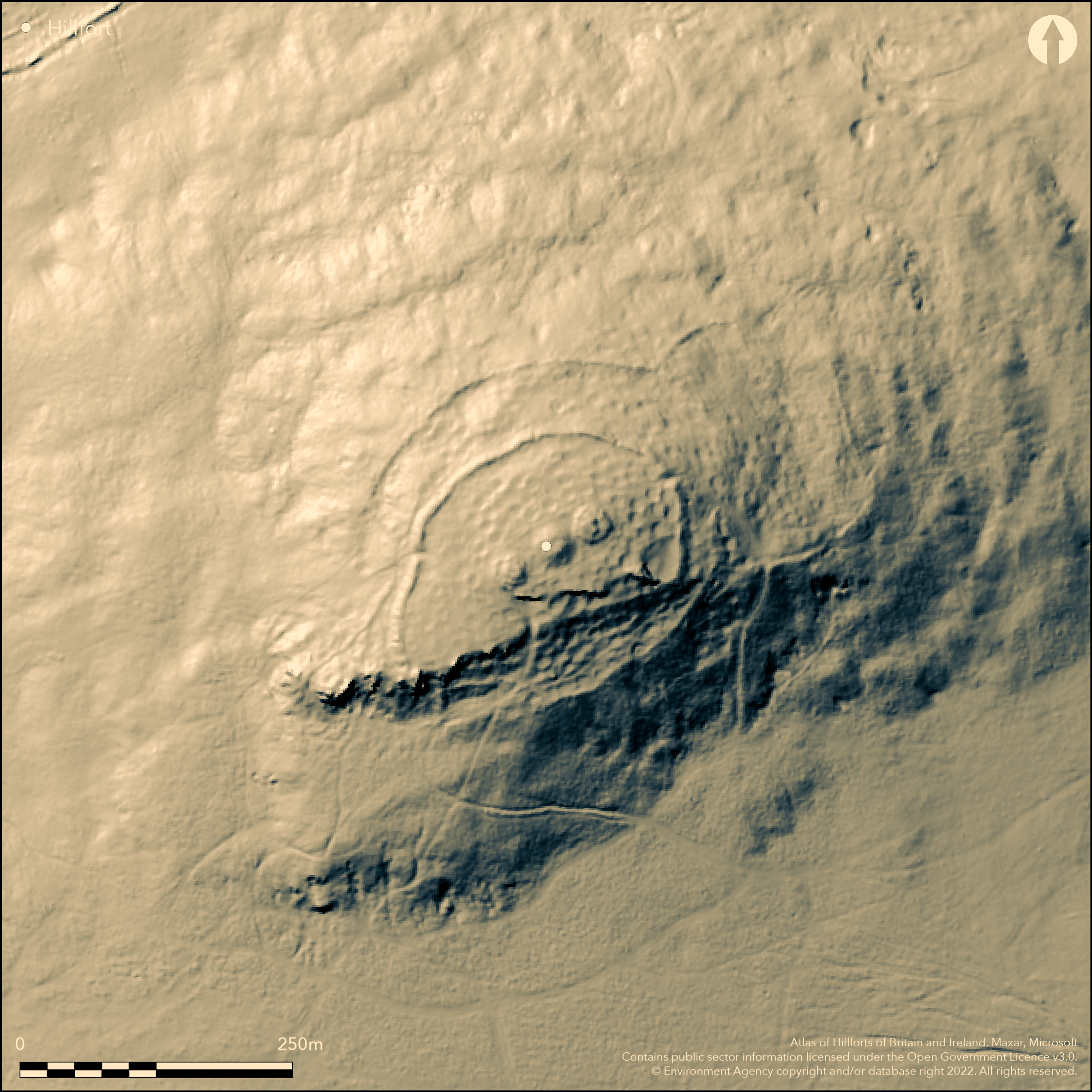
LiDAR 1m DTM Hillshade
Satellite Imagery
LiDAR 1m DTM Hillshade
Satellite Imagery
Scroll left/right to view further images.
HER: Dyfed 1010 (None)
NMR: SN 13 SE (90948)
SM: PE010(PEM)
NGR: SN 1577 3360
X: 215770 Y: 233600 (OSGB36)
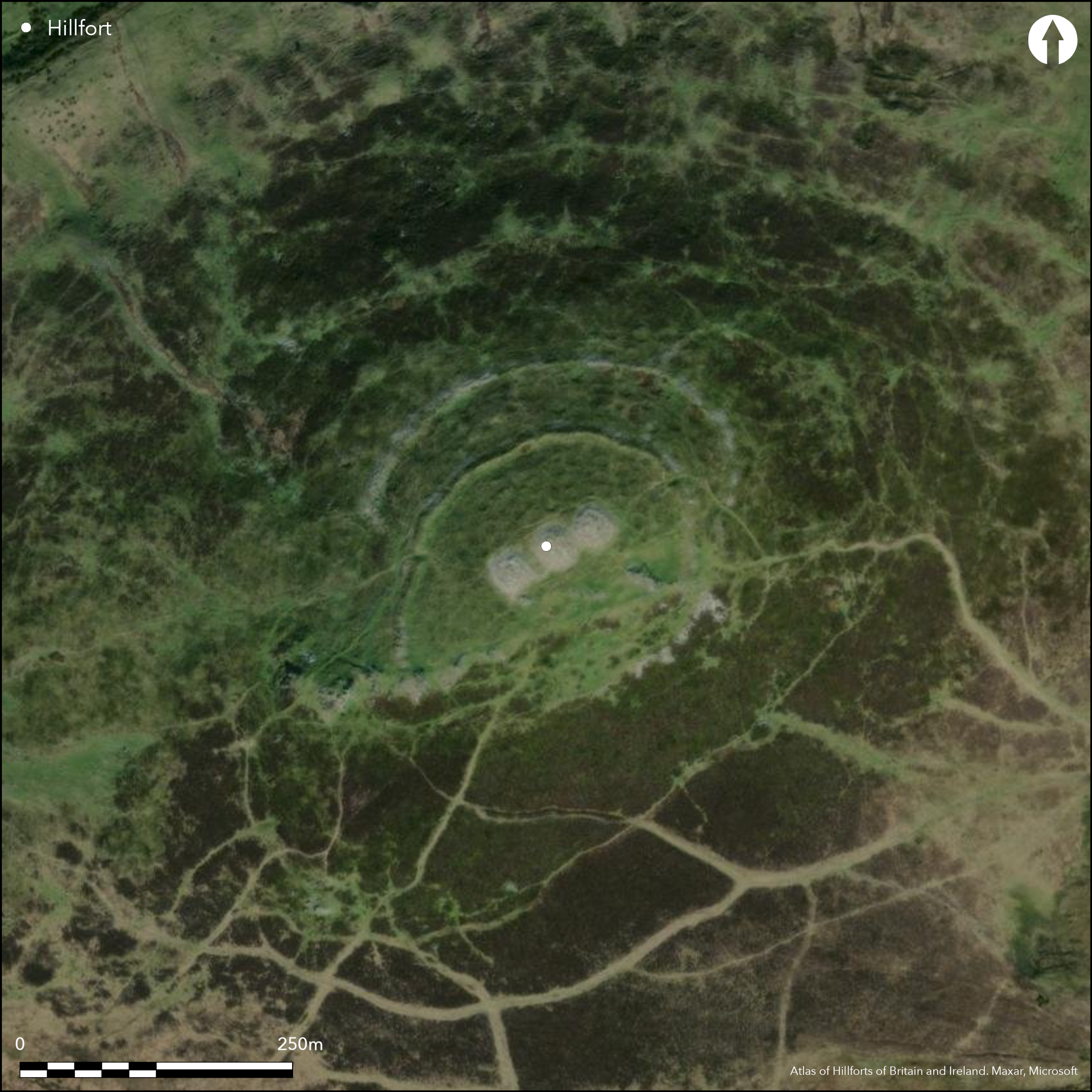
Major, rocky, contour hillfort located high above the headwaters of the Afon Taf at E end of the Preseli range. Strategic position to command possible routes. Steep or moderate to strong surrounding slopes. Circuit comprises two widely-spaced, now dilapidated and vegetation covered, stone/earth banks, with traces of flanking ditches, and measuring c. 180m E-W by 120m N-S and area c. 2.16ha. Inner bank rises c. 1m above interior and c. 3m-4m above ditch, into which it has largely collapsed, masking its outline. Outer bank less, with dry-stone wall facing visible on inner and outer face, as well as on outer face of inner bank. Set against natural cliffs on S side, where no built defence. Outer bank meets inner on W side and here simple entrance through inner. Simple entrance gap also on inner bank E side. The wide spacing between the two banks, seems to delineate an enclosure or annexe in own right. To NE, probably later, sub-rectangular annexe, c. 145m by 75m attached to outer bank, and now defined by vegetation-covered stony bank. Site notable for three Bronze Age cairns on domed summit. Sites of at least 227 definite hut platforms in interior, and 42 fainter and possible sites. Early excavations in 1899 by Rev. S. Baring-Gould found 220 of these sites, together with Iron Age and Roman pottery, spindle-whorls, fine glass beads and a jet ring from some of these platforms, consistent with late prehistoric Ronano-British occupation. Many sling stones also found (Baring Gould et al 1900, 210). New survey by RCAHMW and researchers from Portsmouth Polytechnic in 1988 provided first detailed plan. Very stony site under moorland rough grazing. Outstanding and well-preserved site despite fallen stone. On 1st Ed. OS map (1889).
Citizen Science: ✗
Reliability of Data: Confirmed
Reliability of Interpretation: Confirmed
X: -521359 Y: 6794743 (EPSG: 3857)
Longitude: -4.683448201970227 Latitude: 51.97022228615858 (EPSG:4326)
Country: Wales
Current County or Unitary Authority: Pembrokeshire
Historic County: Pembrokeshire
Current Parish/Community/Council/Townland: Crymych
Outstanding and well-preserved despite fallen stone.
| Extant | ✓ |
| Cropmark | ✗ |
| Likely Destroyed | ✗ |
Upland grazing with much rock on surface.
| Woodland | ✗ |
| Commercial Forestry Plantation | ✗ |
| Parkland | ✗ |
| Pasture (Grazing) | ✓ |
| Arable | ✗ |
| Scrub/Bracken | ✗ |
| Bare Outcrop | ✗ |
| Heather/Moorland | ✓ |
| Heath | ✗ |
| Built-up | ✗ |
| Coastal Grassland | ✗ |
| Other | ✗ |
Major rocky contour hillfort high above the headwaters of the Afon Taf at E end of the Preseli range. Strategic position to command possible routes. Steep or moderate to strong surrounding slopes.
| Contour Fort | ✓ |
| Partial Contour Fort | ✗ |
| Promontory Fort | ✗ |
| Hillslope Fort | ✗ |
| Level Terrain Fort | ✗ |
| Marsh Fort | ✗ |
| Multiple Enclosure Fort | ✗ |
| Hilltop | ✓ |
| Coastal Promontory | ✗ |
| Inland Promontory | ✗ |
| Valley Bottom | ✗ |
| Knoll/Hillock/Outcrop | ✗ |
| Ridge | ✓ |
| Cliff/Plateau-edge/Scarp | ✗ |
| Hillslope | ✗ |
| Lowland | ✗ |
| Spur | ✗ |
Dominant Topographic Feature: Hill top
| North | ✗ |
| Northeast | ✗ |
| East | ✗ |
| Southeast | ✗ |
| South | ✗ |
| Southwest | ✗ |
| West | ✗ |
| Northwest | ✗ |
| Level | ✓ |
Altitude: 343.0m
N/A
Iron Age and Roman pottery, spindle-whorls, fine glass beads and a jet ring suggest late Iron Age/Romano-British occupation.
Reliability: C - Low
| Pre 1200BC | ✗ |
| 1200BC - 800BC | ✗ |
| 800BC - 400BC | ✗ |
| 400BC - AD50 | ✓ |
| AD50 - AD400 | ✓ |
| AD400 - AD 800 | ✗ |
| Post AD800 | ✗ |
| Unknown | ✗ |
| Pre Hillfort: | None |
| Post Hillfort: | None |
| Artefactual: | Iron Age and Roman pottery, spindle-whorls, fine glass beads and a jet ring. |
On 1st Ed. OS map (1889). Small excavation by Rev. S. Baring-Gould 1899. Full survey G.H. Williams 1969. Field observation OS 1974. Field observation AMB 1981. Field observations CADW, 1991, 1998, 2002. New survey by RCAHMW and researchers from Portsmouth Polytechnic 1988 provided first detailed plan. Field Observation DAT/2006. RCAHMW plan published in Driver (2007). Cambria Archaeology defended enclosures survey 2006-2007.
| 1st Identified Map Depiction (1889): | None |
| Excavation (1899): | Rev. S. Baring-Gould et al. |
| Other (1969): | Full survey G.H. Williams. |
| Other (1973): | Visit by Hillfort Study Group |
| Other (1974): | Field observation OS. |
| Other (1981): | Field observation AMB. |
| Other (1988): | Survey by RCAHMW and researchers from Portsmouth Polytechnic. |
| Other (2006): | Field observation DAT. |
| Other (2007): | RCAHMW plan published in Driver (2007). |
| Other (2011): | Visited by Hillfort Study Group |
| Other (None): | Field observations CADW. |
| Other (None): | Cambria Archaeology defended enclosures survey. |
Hut platforms clearly seen together with three Bronze Age cairns. Iron Age and Roman pottery, spindle-whorls, fine glass beads and a jet ring.
Afon Bannon/stream 0.6 km outside fort.
| None | ✓ |
| Spring | ✗ |
| Stream | ✗ |
| Pool | ✗ |
| Flush | ✗ |
| Well | ✗ |
| Other | ✗ |
269 stone and grass covered hut platforms visible.
| No Known Features | ✗ |
| Round Stone Structures | ✓ |
| Rectangular Stone Structures | ✗ |
| Curvilinear Platforms | ✓ |
| Other Roundhouse Evidence | ✗ |
| Pits | ✗ |
| Quarry Hollows | ✗ |
| Other | ✗ |
Hut platforms investigated.
| No Known Excavation | ✗ |
| Pits | ✗ |
| Postholes | ✗ |
| Roundhouses | ✓ |
| Rectangular Structures | ✗ |
| Roads/Tracks | ✗ |
| Quarry Hollows | ✗ |
| Other | ✗ |
| Nothing Found | ✗ |
None
| No Known Geophysics | ✓ |
| Pits | ✗ |
| Roundhouses | ✗ |
| Rectangular Structures | ✗ |
| Roads/Tracks | ✗ |
| Quarry Hollows | ✗ |
| Other | ✗ |
| Nothing Found | ✗ |
Iron Age and Roman pottery, spindle-whorls, fine glass beads and a jet ring.
| No Known Finds | ✗ |
| Pottery | ✓ |
| Metal | ✗ |
| Metalworking | ✗ |
| Human Bones | ✗ |
| Animal Bones | ✗ |
| Lithics | ✗ |
| Environmental | ✗ |
| Other | ✓ |
Hut platforms clearly seen together with three Bronze Age cairns.
| APs Not Checked | ✗ |
| None | ✗ |
| Roundhouses | ✗ |
| Rectangular Structures | ✗ |
| Pits | ✗ |
| Postholes | ✗ |
| Roads/Tracks | ✗ |
| Other | ✓ |
Many breaks, total not defined, but gap on S probably modern. Outer bank meets inner on W side and here simple entrance through inner. Simple entrance gap also on inner bank E side.
| None: | Many breaks, total not defined, but gap on S probably modern. |
| 2: | None |
Guard Chambers: ✗
Chevaux de Frise: ✗
| 1. Simple Gap (East): | Entrance to main enclosure. |
| 2. Simple Gap (West): | Entrance to main enclosure. |
Circuit comprises two widely-spaced, now dilapidated and vegetation covered, stone/earth banks, with traces of flanking ditches. Inner bank rises c. 1m above interior and c. 3m-4m above ditch, into which it has largely collapsed, masking its outline. Outer bank less, with dry-stone wall facing visible on inner and outer face, as well as on outer face of inner bank. Set against natural cliffs on S side, where no built defence. Outer bank meets inner on W side.
| Area 1: | 2.16ha. |
| Total: | 2.16ha. |
Total Footprint Area: Noneha.
None
| ✓ | Overall three possible enclosures, of which innermost, on the summit, probably earliest. |
| ✗ | Set against natural slopes on S side. |
| NE Quadrant: | 2 |
| SE Quadrant: | 2 |
| SW Quadrant: | 2 |
| NW Quadrant: | 2 |
| Total: | 2 |
| Partial Univallate | ✗ |
| Univallate | ✗ |
| Partial Bivallate | ✗ |
| Bivallate | ✓ |
| Partial Multivallate | ✗ |
| Multivallate | ✗ |
| Unknown | ✗ |
| Partial Univallate | ✗ |
| Univallate | ✓ |
| Partial Bivallate | ✗ |
| Bivallate | ✗ |
| Partial Multivallate | ✗ |
| Multivallate | ✗ |
Ramparts now part dry-stone and part-earth with stone revetment. Originally probably stone walls.
| None | ✗ |
| Earthen Bank | ✓ |
| Stone Wall | ✓ |
| Rubble | ✓ |
| Wall-walk | ✗ |
| Evidence of Timber | ✗ |
| Vitrification | ✗ |
| Other Burning | ✗ |
| Palisade | ✗ |
| Counter Scarp Bank | ✗ |
| Berm | ✗ |
| Unfinished | ✗ |
| Other | ✗ |
None
| None | ✗ |
| Earthen Bank | ✗ |
| Stone Wall | ✓ |
| Murus Duplex | ✗ |
| Timber-framed | ✗ |
| Timber-laced | ✗ |
| Vitrification | ✗ |
| Other Burning | ✗ |
| Palisade | ✗ |
| Counter Scarp Bank | ✗ |
| Berm | ✗ |
| Unfinished | ✗ |
| No Known Excavation | ✗ |
| Other | ✗ |
| ✗ | No defence on S side. |
| ✓ | Faint traces of ditch to main enclosure. |
Number of Ditches: 1
| ✓ | As result of wide spacing of two main ramparts, gap seem to define an enclosure or annexe in own right, but To NE, a, probably later, sub-rectangular annexe, c. 145m by 75m, is attached to outer bank, and now defined by vegetation-covered stony bank. |
Baring Gould, S., Burnard, R. and Anderson, I.K. 1900. Exploration of Moel Trigarn, Arch Camb, 54, 189-211.
Crossley, D.W. 1963. List of Hill-Forts and other earthworks in Pembrokeshire, Bull Board Celtic Stud, 20, 189.
Driver. T. 2007. Pembrokeshire: historic landscapes from the air, Aberystwyth: RCAHMW.
Murphy, K., Ramsey, R., Poucher, P. and Page, M. 2007. A Survey of Defended Enclosures in Pembrokeshire, 2006-2007: Gazetteer of Ordnance Survey Grid Squares SN03, SN13 and SN23. Cambria Archaeology Report No. 2007/01, Project Record No. 54269, Llandeilo: Cambria Archaeology.
RCAMWM 1925. An inventory of the ancient monuments in Wales and Monmouthshire, VII, County of Pembroke, London: HMSO, No. 1088.
Rees, S. 1992. A guide to ancient and historic Wales - Dyfed, London: HMSO, 59-60.
Atlas of Hillforts:
Wikidata:
This work is licensed under CC BY-SA 4.0![]()
![]()
![]() and should be cited as:
and should be cited as:
Lock, Gary and Ralston, Ian. 2024. Atlas of Hillforts of Britain and Ireland. Available at: https://hillforts.arch.ox.ac.uk
Document Version 1.1