LiDAR 1m DTM Hillshade
Satellite Imagery
LiDAR 1m DTM Hillshade
Satellite Imagery
Scroll left/right to view further images.
HER: Herefordshire MHE413 (910)
NMR: SO 53 SW 1 (110371)
SM: 1001754
NGR: SO 503330
X: 350350 Y: 233050 (OSGB36)
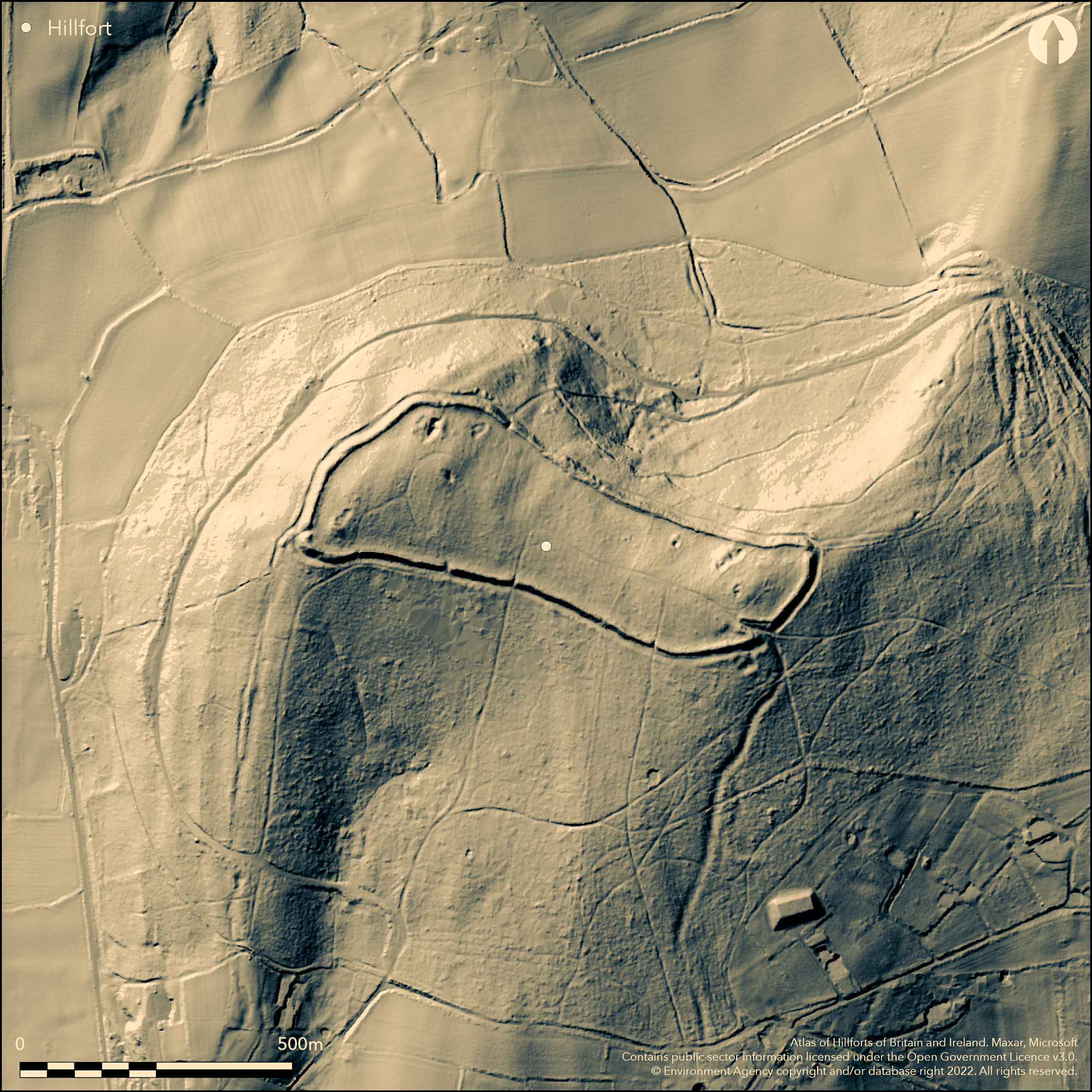
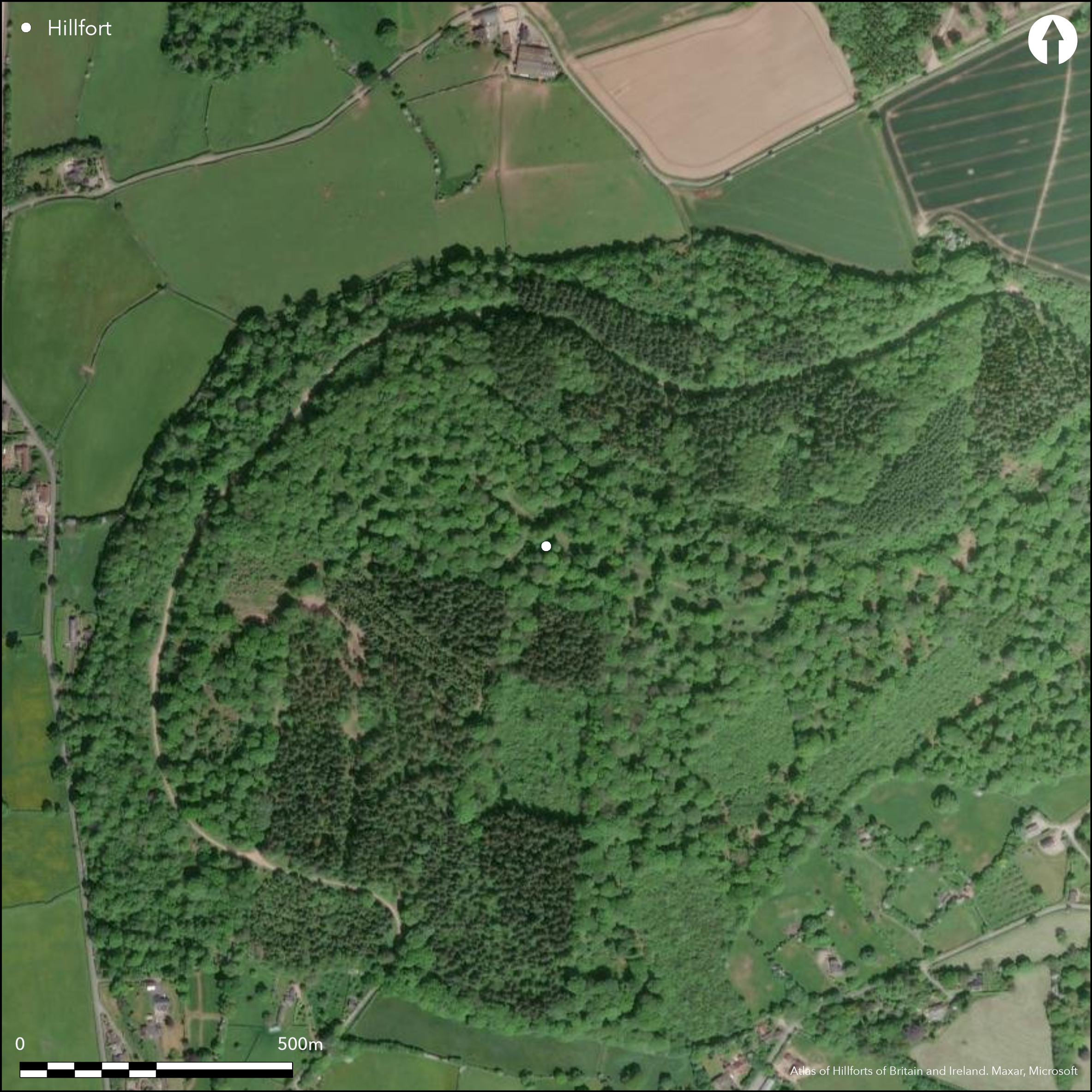
Large, wooded, univallate, partial contour hillfort located on Aconbury HIll, following the contours but sloping to the W, and on the interfluve above the Rivers Wye and Severn. Precipitous slopes to the W and N. Rampart surrounds camp, with a surviving main ditch to the S and E, elsewhere not visible, although it is possible that the steep slopes on the N and W precluded a ditch here. Internal area c. 7.1ha and footprint 9.3ha. The rampart rampart reaches up to 4.5m in the S where the ditch is up to 1.5m deep and is impressive on the W overlooking steep slopes. Possible internal revetments within ramparts. Berm on N and W. Internal quarry scoops, especially on the S and N side. Slight investigations 1948-51 found occupation similar to Sutton Walls hillfort (Atlas No 0031) and Dinedor Camp (Atlas No 0013), with pottery similar to the former site. Two original entrances and four modern gaps. Occupied during the Civil War in 1642 and 1645. Mixed woodland since 19th century with internal tracks. Bracken, bramble, sapling and coppice re-growth. Visitor erosion of paths where cross rampart, with horse and quad bikes. Some quarrying. On 1st Ed. OS map (1888).
Citizen Science: ✗
Reliability of Data: Confirmed
Reliability of Interpretation: Confirmed
X: -303295 Y: 6798973 (EPSG: 3857)
Longitude: -2.724548210189332 Latitude: 51.99362825518932 (EPSG:4326)
Country: England
Current County or Unitary Authority: Herefordshire
Historic County: Herefordshire
Current Parish/Community/Council/Townland: Aconbury
Main ditch gone on N and W sides. Visitor erosion of paths where cross rampart, with horse and quad bikes. Vegetation re-growth. Some quarrying.
| Extant | ✓ |
| Cropmark | ✗ |
| Likely Destroyed | ✗ |
Mixed woodland since 19th century with internal tracks. Bracken, bramble, sapling and coppice re-growth. Some quarrying.
| Woodland | ✓ |
| Commercial Forestry Plantation | ✗ |
| Parkland | ✗ |
| Pasture (Grazing) | ✗ |
| Arable | ✗ |
| Scrub/Bracken | ✓ |
| Bare Outcrop | ✗ |
| Heather/Moorland | ✗ |
| Heath | ✗ |
| Built-up | ✗ |
| Coastal Grassland | ✗ |
| Other | ✓ |
Partial contour fort following the natural contours and which also appears to cut off a promontory, but sloping to the W. Located above the River Wye and Hereford to the E and the valley of the Worm Brook to the W, on the interfluve between the Rivers Wye and Severn catchments. Precipitous slopes to the W and N.
| Contour Fort | ✗ |
| Partial Contour Fort | ✓ |
| Promontory Fort | ✓ |
| Hillslope Fort | ✗ |
| Level Terrain Fort | ✗ |
| Marsh Fort | ✗ |
| Multiple Enclosure Fort | ✗ |
| Hilltop | ✓ |
| Coastal Promontory | ✗ |
| Inland Promontory | ✓ |
| Valley Bottom | ✗ |
| Knoll/Hillock/Outcrop | ✗ |
| Ridge | ✗ |
| Cliff/Plateau-edge/Scarp | ✗ |
| Hillslope | ✗ |
| Lowland | ✗ |
| Spur | ✗ |
Dominant Topographic Feature: Hill top, part promontory.
| North | ✗ |
| Northeast | ✗ |
| East | ✗ |
| Southeast | ✗ |
| South | ✗ |
| Southwest | ✗ |
| West | ✓ |
| Northwest | ✗ |
| Level | ✗ |
Altitude: 276.0m
N/A
The finding of Iron Age and Roman pottery suggests late Iron Age to Roman period occupation. Sherds similar to Sutton Walls (Atlas No 0031).
Reliability: C - Low
| Pre 1200BC | ✗ |
| 1200BC - 800BC | ✗ |
| 800BC - 400BC | ✓ |
| 400BC - AD50 | ✓ |
| AD50 - AD400 | ✓ |
| AD400 - AD 800 | ✗ |
| Post AD800 | ✗ |
| Unknown | ✗ |
| Pre Hillfort: | None |
| Post Hillfort: | None |
| Artefactual: | Pottery evidence. |
| Artefactual: | The finding of Iron Age and Roman pottery suggests late Iron Age to Roman period occupation. |
In Aubrey's Monumenta Britannica (1665-1693). On 1st Ed. OS map (1888). Surface examination 1948-51 as part of wider investigations by Kenyon (1953) following Sutton Walls excavations. Herefordshire Council survey 2012.
| 1st Identified Map Depiction (1888): | Ordnance Survey |
| Other (1951): | Surface collection of sherds by Kenyon |
| Other (2012): | Herefordshire Council survey. |
| 1st Identified Written Reference (None): | Aubrey's Monumenta Britannica. |
Little information about interior was gleaned from the investigations, but Kenyon suggested that occupation of the site was similar to that found at Sutton Walls and Dinedor Camp. Internal quarry scoops, especially on the N and S sides
Spring 0.3km located outside the hillfort
| None | ✓ |
| Spring | ✗ |
| Stream | ✗ |
| Pool | ✗ |
| Flush | ✗ |
| Well | ✗ |
| Other | ✗ |
Little information is available from surface evidence, but there are internal quarry scoops, especially on the N and S sides.
| No Known Features | ✗ |
| Round Stone Structures | ✗ |
| Rectangular Stone Structures | ✗ |
| Curvilinear Platforms | ✗ |
| Other Roundhouse Evidence | ✗ |
| Pits | ✗ |
| Quarry Hollows | ✓ |
| Other | ✗ |
None
| No Known Excavation | ✓ |
| Pits | ✗ |
| Postholes | ✗ |
| Roundhouses | ✗ |
| Rectangular Structures | ✗ |
| Roads/Tracks | ✗ |
| Quarry Hollows | ✗ |
| Other | ✗ |
| Nothing Found | ✗ |
None
| No Known Geophysics | ✓ |
| Pits | ✗ |
| Roundhouses | ✗ |
| Rectangular Structures | ✗ |
| Roads/Tracks | ✗ |
| Quarry Hollows | ✗ |
| Other | ✗ |
| Nothing Found | ✗ |
Quantity of Iron Age sherds similar to those found at Sutton Walls, with possible Roman sherds.
| No Known Finds | ✗ |
| Pottery | ✓ |
| Metal | ✗ |
| Metalworking | ✗ |
| Human Bones | ✗ |
| Animal Bones | ✗ |
| Lithics | ✗ |
| Environmental | ✗ |
| Other | ✗ |
None
| APs Not Checked | ✓ |
| None | ✗ |
| Roundhouses | ✗ |
| Rectangular Structures | ✗ |
| Pits | ✗ |
| Postholes | ✗ |
| Roads/Tracks | ✗ |
| Other | ✗ |
Two original entrances; the SE inturned. The SW is more complex, where the S rampart curves behind the W rampart, which itself extends S, so increasing the nature of the defences of what is possibly the principal entrance. There is a possible external ramp.
| 6: | Two original and four modern gaps. |
| 2: | Two original inturned entrances at SE and SW corners. Probably modern entrances to S and N. |
Guard Chambers: ✗
Chevaux de Frise: ✗
| 1. In-turned (South east): | A less complex, than that to the W, but, nevertheless, impressive inturned entrance. |
| 2. In-turned (South west): | The SW is more complex, where the S rampart curves behind the W rampart, which itself extends S, so increasing the nature of the defences of what is possibly the principal entrance. |
| 2. Other Forms (South west): | Complex nature of ramparts here. |
Univallate hillfort with complete circuit, but the ditch is only visible on S and E sides, destroyed, or never built, elsewhere. The rampart reaches up to 4.5m high to S, where ditch to 1.5m, but only 0.5m in W.
| Area 1: | 7.1ha. |
| Total: | 7.1ha. |
Total Footprint Area: 9.3ha.
None
| ✗ | Univallate hillfort with complete circuit. |
| ✓ | Single rampart continues around circuit. |
| NE Quadrant: | 1 |
| SE Quadrant: | 1 |
| SW Quadrant: | 1 |
| NW Quadrant: | 1 |
| Total: | 1 |
| Partial Univallate | ✗ |
| Univallate | ✓ |
| Partial Bivallate | ✗ |
| Bivallate | ✗ |
| Partial Multivallate | ✗ |
| Multivallate | ✗ |
| Unknown | ✗ |
| Partial Univallate | ✗ |
| Univallate | ✗ |
| Partial Bivallate | ✗ |
| Bivallate | ✗ |
| Partial Multivallate | ✗ |
| Multivallate | ✗ |
Little surface evidence of features and the bank is possibly earthen. A berm exists to the N and W, created at the base of the rampart. Possible internal revetments were found within the ramparts.
| None | ✗ |
| Earthen Bank | ✓ |
| Stone Wall | ✗ |
| Rubble | ✗ |
| Wall-walk | ✗ |
| Evidence of Timber | ✗ |
| Vitrification | ✗ |
| Other Burning | ✗ |
| Palisade | ✗ |
| Counter Scarp Bank | ✗ |
| Berm | ✓ |
| Unfinished | ✗ |
| Other | ✓ |
None
| None | ✗ |
| Earthen Bank | ✗ |
| Stone Wall | ✗ |
| Murus Duplex | ✗ |
| Timber-framed | ✗ |
| Timber-laced | ✗ |
| Vitrification | ✗ |
| Other Burning | ✗ |
| Palisade | ✗ |
| Counter Scarp Bank | ✗ |
| Berm | ✗ |
| Unfinished | ✗ |
| No Known Excavation | ✗ |
| Other | ✗ |
| ✗ | None |
| ✓ | Main ditch only present on the S and E sides, elsewhere destroyed or never constructed. |
Number of Ditches: 1
| ✗ | None |
Dorling, P. and Wigley, A. 2012. Assessment of the archaeological and conservation status of major later prehistoric enclosures in Herefordshire and Shropshire, EH PNUM, Version 3.2, Hereford and Shrewsbury: Herefordshire Council/Shropshire Council.
Kenyon, K.M. 1953. Excavations at Sutton Walls, Herefordshire 1948-51, Archaeol J, 110, 25-6.
Page, W. 1908. The Victoria County History of the County of Herefordshire, 1, 201-2, London: St Catherine Press.
RCHME 1930. An Inventory of the Historical Monuments in Herefordshire, 1, SW, 13-14, London: HMSO.
Stanford, S. C. (ed.) 1976. Guide to Prehistoric and Roman Sites in Herefordshire. Woolhope Naturalists' Field Club Archaeological Research Section, 12-13.
Atlas of Hillforts:
Wikidata:
This work is licensed under CC BY-SA 4.0![]()
![]()
![]() and should be cited as:
and should be cited as:
Lock, Gary and Ralston, Ian. 2024. Atlas of Hillforts of Britain and Ireland. Available at: https://hillforts.arch.ox.ac.uk
Document Version 1.1