LiDAR 1m DTM Hillshade
Satellite Imagery
LiDAR 1m DTM Hillshade
Satellite Imagery
Scroll left/right to view further images.
HER: Herefordshire MHE52 (344)
NMR: SO 56 SW 3 (110884)
SM: 1007316
NGR: SO 547602
X: 354700 Y: 260200 (OSGB36)
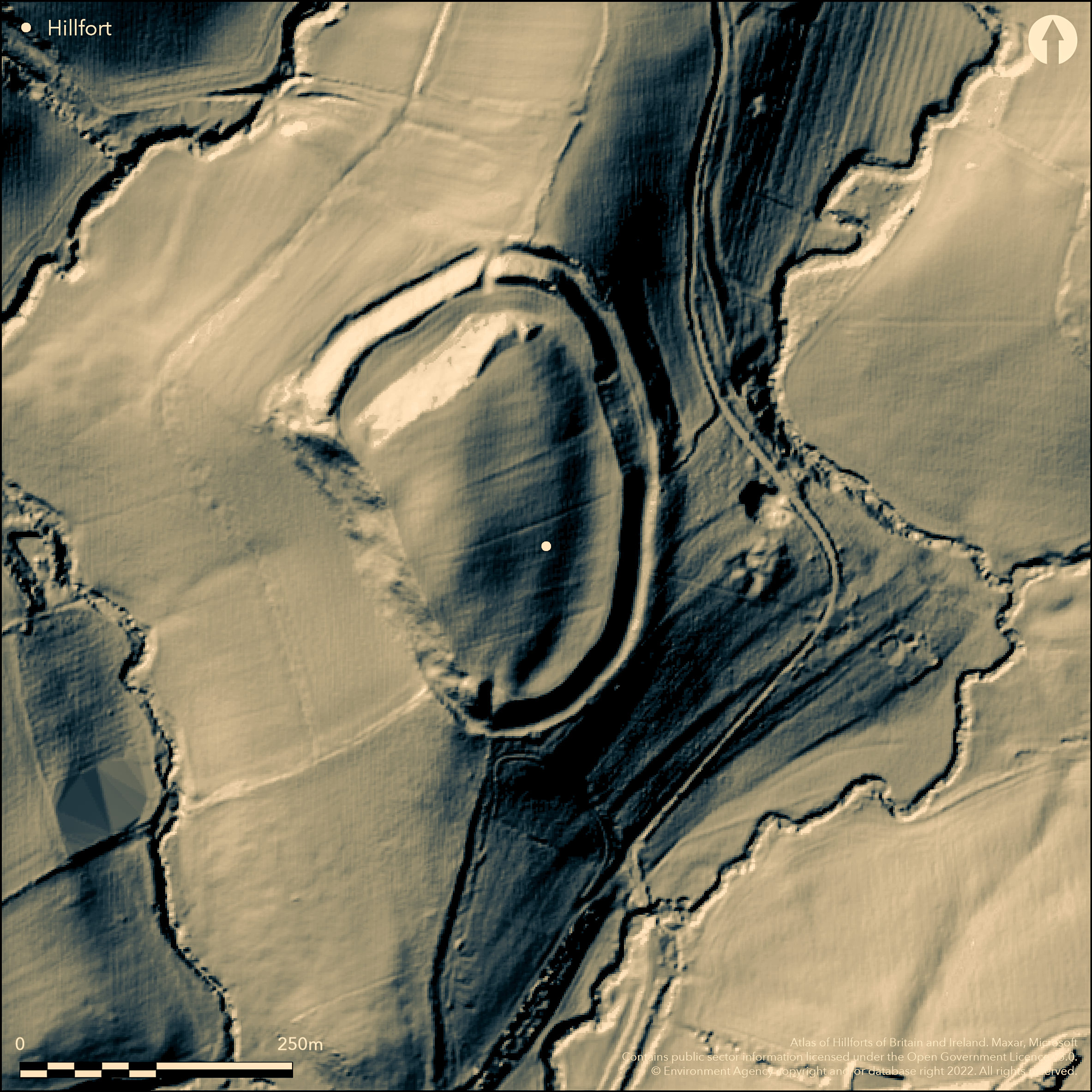
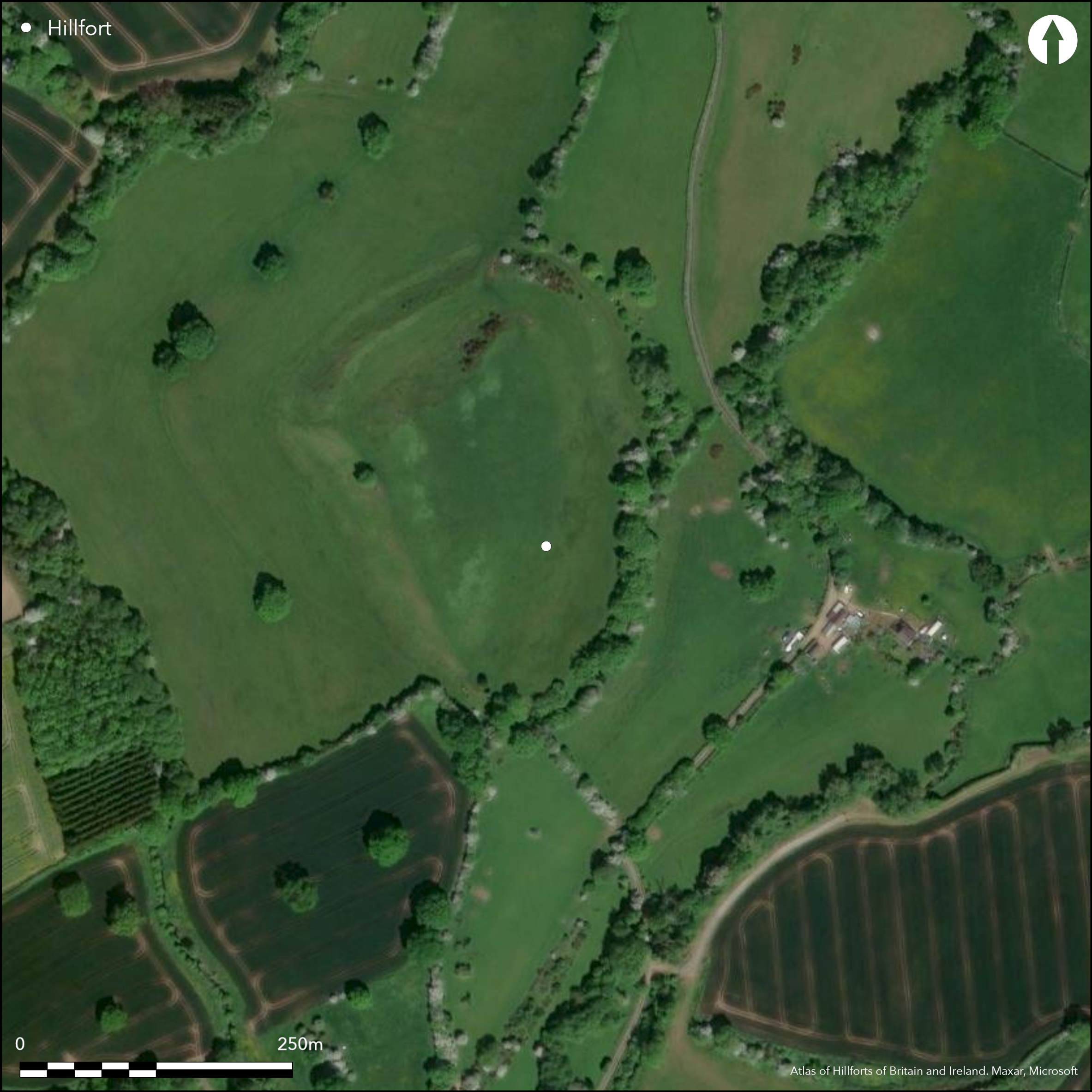
Univallate, contour hillfort located on summit of rounded hill at watershed of Whyle Brook and tributary and overlooking confluence, with River Lugg valley to W. Steep surrounding slopes. Irregular shaped with area c. 4.1ha, defined differentially by single rampart to 5.1m high, with part-buried outer ditch and counterscarp bank to N, E and possibly S, rising to 1.8m. Counterscarp bank is complex and difficult to unravel and probably also existed on W. Mostly removed by cultivation and on E merges into a berm before reappearing; possibly result of landslip or not finished. Three entrances, simple gap possibly modern to N, that to NW complex with possible hornwork, and that on S inturned. Potatoes once grown on the site, but now under management agreement. Natural and animal erosion with sheep scrapes. General improvement as part of management agreements. Public Right of Way and permissive paths. Past tree removal is causing erosion around the stumps. Undated. On 1st Ed. OS map (1888).
Citizen Science: ✗
Reliability of Data: Confirmed
Reliability of Interpretation: Confirmed
X: -296646 Y: 6843289 (EPSG: 3857)
Longitude: -2.6648189224193426 Latitude: 52.238082103131894 (EPSG:4326)
Country: England
Current County or Unitary Authority: Herefordshire
Historic County: Herefordshire
Current Parish/Community/Council/Townland: Kimbolton
Natural and animal erosion with sheep scrapes. General improvement as part of management agreements. Public Right of Way and permissive paths. Past tree removal is causing erosion around the stumps. Site now under management agreements.
| Extant | ✓ |
| Cropmark | ✗ |
| Likely Destroyed | ✗ |
Potatoes once grown on the site, but vegetation now managed.
| Woodland | ✗ |
| Commercial Forestry Plantation | ✗ |
| Parkland | ✗ |
| Pasture (Grazing) | ✓ |
| Arable | ✗ |
| Scrub/Bracken | ✓ |
| Bare Outcrop | ✗ |
| Heather/Moorland | ✗ |
| Heath | ✗ |
| Built-up | ✗ |
| Coastal Grassland | ✗ |
| Other | ✗ |
Univallate, contour hillfort located on summit of rounded hill at watershed of Whyle Brook and tributary and overlooking confluence, with River Lugg valley to W. Steep surrounding slopes.
| Contour Fort | ✓ |
| Partial Contour Fort | ✗ |
| Promontory Fort | ✗ |
| Hillslope Fort | ✗ |
| Level Terrain Fort | ✗ |
| Marsh Fort | ✗ |
| Multiple Enclosure Fort | ✗ |
| Hilltop | ✓ |
| Coastal Promontory | ✗ |
| Inland Promontory | ✗ |
| Valley Bottom | ✗ |
| Knoll/Hillock/Outcrop | ✗ |
| Ridge | ✗ |
| Cliff/Plateau-edge/Scarp | ✗ |
| Hillslope | ✗ |
| Lowland | ✗ |
| Spur | ✓ |
Dominant Topographic Feature: Hill top spur.
| North | ✗ |
| Northeast | ✗ |
| East | ✗ |
| Southeast | ✗ |
| South | ✗ |
| Southwest | ✗ |
| West | ✗ |
| Northwest | ✗ |
| Level | ✓ |
Altitude: 150.0m
N/A
None
Reliability: D - None
| Pre 1200BC | ✗ |
| 1200BC - 800BC | ✗ |
| 800BC - 400BC | ✗ |
| 400BC - AD50 | ✗ |
| AD50 - AD400 | ✗ |
| AD400 - AD 800 | ✗ |
| Post AD800 | ✗ |
| Unknown | ✓ |
| Pre Hillfort: | None |
| Post Hillfort: | None |
On 1st Ed. OS map (1888). Herefordshire Aerial Archaeological Survey 2002-2006. Herefordshire Council survey 2012.
| 1st Identified Map Depiction (1888): | OS map |
| Other (2012): | Herefordshire Council survey 2012. |
| Other (None): | Herefordshire Aerial Archaeological Survey. |
None
Stream 0.1km located outside hillfort
| None | ✓ |
| Spring | ✗ |
| Stream | ✗ |
| Pool | ✗ |
| Flush | ✗ |
| Well | ✗ |
| Other | ✗ |
None
| No Known Features | ✓ |
| Round Stone Structures | ✗ |
| Rectangular Stone Structures | ✗ |
| Curvilinear Platforms | ✗ |
| Other Roundhouse Evidence | ✗ |
| Pits | ✗ |
| Quarry Hollows | ✗ |
| Other | ✗ |
None
| No Known Excavation | ✓ |
| Pits | ✗ |
| Postholes | ✗ |
| Roundhouses | ✗ |
| Rectangular Structures | ✗ |
| Roads/Tracks | ✗ |
| Quarry Hollows | ✗ |
| Other | ✗ |
| Nothing Found | ✗ |
None
| No Known Geophysics | ✓ |
| Pits | ✗ |
| Roundhouses | ✗ |
| Rectangular Structures | ✗ |
| Roads/Tracks | ✗ |
| Quarry Hollows | ✗ |
| Other | ✗ |
| Nothing Found | ✗ |
None
| No Known Finds | ✓ |
| Pottery | ✗ |
| Metal | ✗ |
| Metalworking | ✗ |
| Human Bones | ✗ |
| Animal Bones | ✗ |
| Lithics | ✗ |
| Environmental | ✗ |
| Other | ✗ |
None
| APs Not Checked | ✓ |
| None | ✗ |
| Roundhouses | ✗ |
| Rectangular Structures | ✗ |
| Pits | ✗ |
| Postholes | ✗ |
| Roads/Tracks | ✗ |
| Other | ✗ |
Entrances difficult to unravel. The S entrance is inturned and slightly offset. That on the NW is more complex, although a simple gap in the inner rampart, it is cut back to form a broad inner traverse with ditch and possible hornwork. There has also been quarrying here. N entrance damaged by wagon access and possibly modern.
| 3: | N entrance damaged by wagon access and possibly modern. |
| 2: | S entrance original, that on the NW possibly original and more complex with dry-stone revetment. |
Guard Chambers: ✗
Chevaux de Frise: ✗
| 1. In-turned (South): | The only definite original entrance with good inturn. |
| 2. Simple Gap (North west): | That on the NW is more complex, although a simple gap in the inner rampart, it is cut back to form a broad inner traverse with ditch and possible hornwork. |
| 2. Hornwork (North west): | Possible hornwork. |
Defined differentially by single rampart to 5.1m high, with part-buried outer ditch and counterscarp bank to N, E and possibly S, rising to 1.8m. Counterscarp bank is complex and difficult to unravel and probably also existed on W. Mostly removed by cultivation and on E merges into a berm before re-appearing; possibly result of landslip or not finished.
| Area 1: | 4.1ha. |
| Total: | 4.1ha. |
Total Footprint Area: Noneha.
None
| ✗ | None |
| ✓ | The ramparts are irregular which makes assessment difficult, but generally complete the circuit. |
| NE Quadrant: | 1 |
| SE Quadrant: | 1 |
| SW Quadrant: | 1 |
| NW Quadrant: | 1 |
| Total: | 1 |
| Partial Univallate | ✗ |
| Univallate | ✓ |
| Partial Bivallate | ✗ |
| Bivallate | ✗ |
| Partial Multivallate | ✗ |
| Multivallate | ✗ |
| Unknown | ✗ |
| Partial Univallate | ✗ |
| Univallate | ✗ |
| Partial Bivallate | ✗ |
| Bivallate | ✗ |
| Partial Multivallate | ✗ |
| Multivallate | ✗ |
Bank possibly earthen. Counterscarp bank complex and difficult to unravel and probably also existed on W. Mostly removed by cultivation, and on E merges into a berm before reappearing; possibly result of landslip or not finished.
| None | ✗ |
| Earthen Bank | ✓ |
| Stone Wall | ✗ |
| Rubble | ✗ |
| Wall-walk | ✗ |
| Evidence of Timber | ✗ |
| Vitrification | ✗ |
| Other Burning | ✗ |
| Palisade | ✗ |
| Counter Scarp Bank | ✓ |
| Berm | ✓ |
| Unfinished | ✓ |
| Other | ✗ |
None
| None | ✗ |
| Earthen Bank | ✗ |
| Stone Wall | ✗ |
| Murus Duplex | ✗ |
| Timber-framed | ✗ |
| Timber-laced | ✗ |
| Vitrification | ✗ |
| Other Burning | ✗ |
| Palisade | ✗ |
| Counter Scarp Bank | ✗ |
| Berm | ✗ |
| Unfinished | ✗ |
| No Known Excavation | ✓ |
| Other | ✗ |
| ✗ | None |
| ✓ | None |
Number of Ditches: 1
| ✗ | None |
Dorling, P. and Wigley, A. 2012. Assessment of the archaeological and conservation status of major later prehistoric enclosures in Herefordshire and Shropshire, EH PNUM, Version 3.2, Hereford and Shrewsbury: Herefordshire Council/Shropshire Council.
Page, W. ed. 1908.The Victoria County History of the County of Herefordshire, 1, 214-15, London: St Catherine Press.
RCHME 1934. An Inventory of the Historical Monuments in Herefordshire, 3, 79, London: HMSO.
Atlas of Hillforts:
Wikidata:
This work is licensed under CC BY-SA 4.0![]()
![]()
![]() and should be cited as:
and should be cited as:
Lock, Gary and Ralston, Ian. 2024. Atlas of Hillforts of Britain and Ireland. Available at: https://hillforts.arch.ox.ac.uk
Document Version 1.1