
LiDAR 1m DTM Hillshade
Satellite Imagery
LiDAR 1m DTM Hillshade
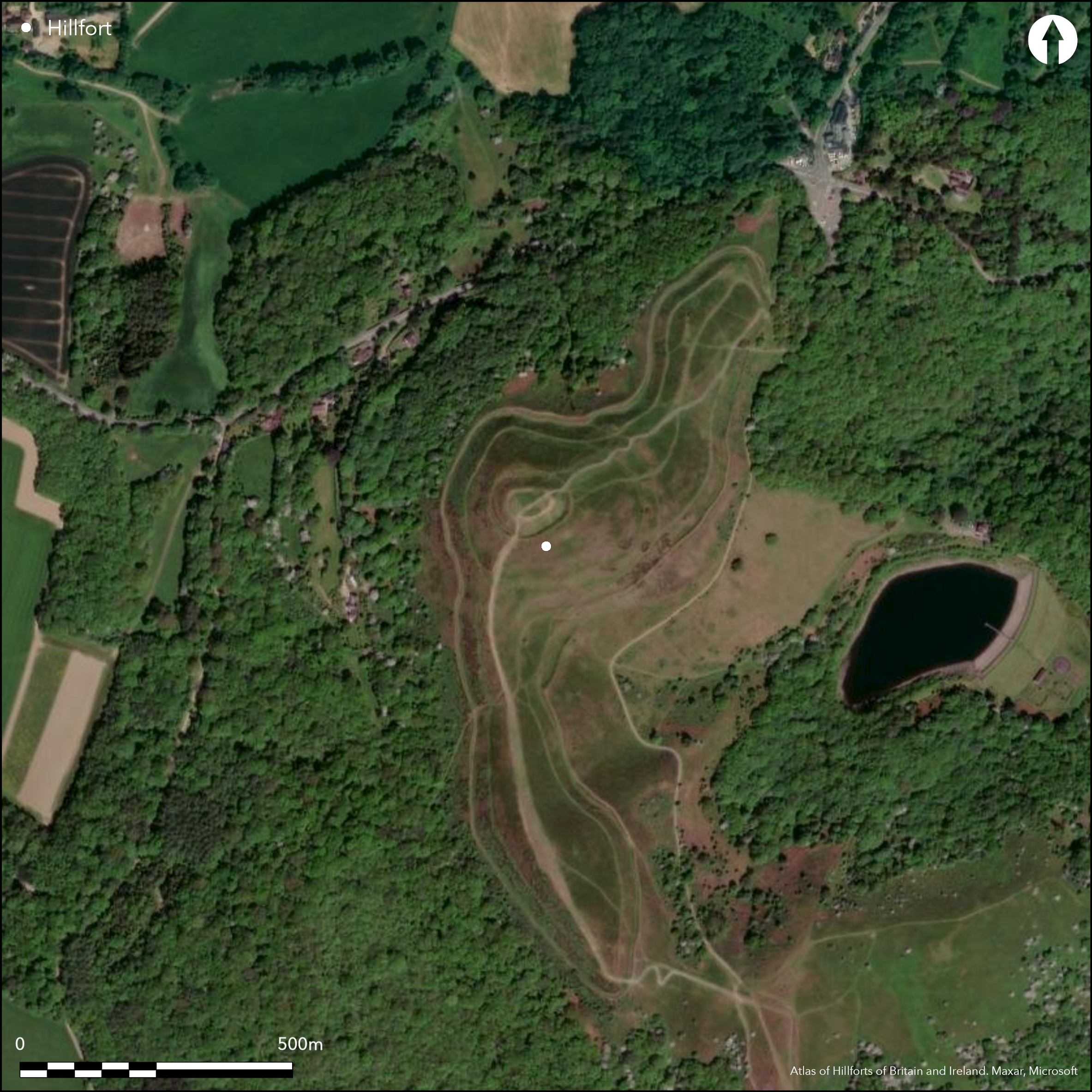
Satellite Imagery
Scroll left/right to view further images.
HER: Herefordshire MHE435 (932); Worcestershire WSM00932
NMR: SO 74 SE 3 (113786)
SM: 1001792
NGR: SO 760400
X: 376000 Y: 240000 (OSGB36)
One of the finest and most spectacular contour hillforts in the country, located on the high ridge of the Malvern Hills above the River Severn valley on the E and River Leadon on the W. Its snaking ramparts encompass the Herefordshire Beacon itself and the S summit, called Millennium Hill. Internal area 14.7ha. Limited excavations were carried out by Hilton Price in 1879 (Hilton Price 1887). The site was surveyed in 1999 as part of the Malvern Hills AONB Project by RCHME (Bowden 2005). Wheeler (1953) suggested four phases to the site. In Phase I, c. 3ha were enclosed by a slight bank (in proportion) and impressive ditch above an artificially steepened scarp. Here the counterscap is massive in places. Possible structure sites have been found. Out-turned entrances were to the NE (strategically positioned) and SW (now faint). In Phase II, the enclosure was enlarged X 4 to about 13.5ha along the 305m contour with deep ditch and four overlapping entrances. The ramparts of Phases I and II are difficult to unravel. At least 118 hut platforms have been identified. In Phase III he suggested that the small 'fortified post' (the ringwork), constructed at the summit of the hill with steep rock-cut ditch and internal bank. In the final phase the Shire Ditch, constructed in about 1287, made use of the counterscarp of the E ditch. From the surveys of 1999, Phases III and IV were reversed, the Shire Ditch being of earlier construction than the ringwork, the latter anything from the Norman conquest to the 14th century, that between the 11th and 14th centuries most likely. One of the few Herefordshire hillforts to have possibly guarded a pass. Visitor numbers great, but erosion repair has taken place. Upland pasture, moorland and scrub, latter, especially on the W side, could be a problem. Rabbit control measures. Otherwise condition generally good. On 1st Ed. OS map (1886).
Citizen Science: ✗
Reliability of Data: Confirmed
Reliability of Interpretation: Confirmed
X: -261765 Y: 6810587 (EPSG: 3857)
Longitude: -2.35147180098148 Latitude: 52.05781891516049 (EPSG:4326)
Country: England; None
Current County or Unitary Authority: Herefordshire; Worcestershire
Historic County: Herefordshire; Worcestershire
Current Parish/Community/Council/Townland: Colwall; Eastnor (Herefordshire); Little Malvern (Worcestershire)
Visitor numbers great, but erosion repair has taken place. Scrub especially on the W side could be a problem. Rabbit control measures. Otherwise condition generally good.
| Extant | ✓ |
| Cropmark | ✗ |
| Likely Destroyed | ✗ |
Upland pasture, moorland and scrub. Medieval ringwork.
| Woodland | ✗ |
| Commercial Forestry Plantation | ✗ |
| Parkland | ✗ |
| Pasture (Grazing) | ✓ |
| Arable | ✗ |
| Scrub/Bracken | ✓ |
| Bare Outcrop | ✗ |
| Heather/Moorland | ✓ |
| Heath | ✗ |
| Built-up | ✗ |
| Coastal Grassland | ✗ |
| Other | ✓ |
One of the finest examples of a contour fort in the country. Located on the high ridge of the Malvern Hills above the River Severn valley on the E and River Leadon on the W. Its snaking ramparts encompass the Herefordshire Beacon itself and the S summit, called Millennium Hill.
| Contour Fort | ✓ |
| Partial Contour Fort | ✗ |
| Promontory Fort | ✗ |
| Hillslope Fort | ✗ |
| Level Terrain Fort | ✗ |
| Marsh Fort | ✗ |
| Multiple Enclosure Fort | ✗ |
| Hilltop | ✓ |
| Coastal Promontory | ✗ |
| Inland Promontory | ✗ |
| Valley Bottom | ✗ |
| Knoll/Hillock/Outcrop | ✗ |
| Ridge | ✓ |
| Cliff/Plateau-edge/Scarp | ✗ |
| Hillslope | ✗ |
| Lowland | ✗ |
| Spur | ✗ |
Dominant Topographic Feature: Malvern Hill crest.
| North | ✗ |
| Northeast | ✗ |
| East | ✗ |
| Southeast | ✗ |
| South | ✗ |
| Southwest | ✗ |
| West | ✗ |
| Northwest | ✗ |
| Level | ✓ |
Altitude: 338.0m
Boundary Type: County
The earlier enclosure of Phase I could be late Bronze Age or early Iron Age whist the main enclosure (Phase II) is thought to be of the middle Iron Age. The ringwork on the summit is thought to be medieval. There is only slight evidence of Romano-British activity. There is no evidence of pre-hillfort activity, althought it has been speculated that the medieval ringwork could be a re-working of an earlier enclosure. No dating is entirely secure.
Reliability: C - Low
| Pre 1200BC | ✗ |
| 1200BC - 800BC | ✗ |
| 800BC - 400BC | ✓ |
| 400BC - AD50 | ✓ |
| AD50 - AD400 | ✓ |
| AD400 - AD 800 | ✗ |
| Post AD800 | ✓ |
| Unknown | ✗ |
| Pre Hillfort: | None |
| Post Hillfort: | None |
| Morphology/Earthwork/Typology: | General morphological survey and historical references suggest dating. |
In Aubrey's Monumenta Britannica (1665-1693). On 1st Ed. OS map (1886). Excavation by Hilton-Price in 1879, General Pitt Rivers visiting the excavations and drawing a plan of the site. The site was surveyed 1999 as part of the Malvern Hills AONB Project by RCHME (Bowden 2005). Time Team special 2008. Herefordshire Council survey 2012.
| Excavation (1879): | Excavation by Hilton Price |
| Other (1879): | Plan of the site drawn by Pitt Rivers. |
| 1st Identified Map Depiction (1886): | OS map. |
| Other (1999): | RCHME survey (Bowden 2005). |
| Other (2008): | Time Team special. |
| Other (2012): | Herefordshire Council survey. |
| 1st Identified Written Reference (None): | Aubrey's Monumenta Britannica. |
| Earthwork Survey (None): | EH topographical survey (Bowden). |
At least 118 hut platforms have been identified in the Phase II enclosure. Quarry hollows also found on the hillfort.
Possible spring within the bottom of the first phase ditch. Spring 0.25km outside hillfort.
| None | ✗ |
| Spring | ✓ |
| Stream | ✗ |
| Pool | ✗ |
| Flush | ✗ |
| Well | ✗ |
| Other | ✗ |
At least 118 hut platforms have been identified in the Phase II enclosure. Quarry hollows also found on the hillfort.
| No Known Features | ✗ |
| Round Stone Structures | ✗ |
| Rectangular Stone Structures | ✗ |
| Curvilinear Platforms | ✓ |
| Other Roundhouse Evidence | ✗ |
| Pits | ✗ |
| Quarry Hollows | ✓ |
| Other | ✗ |
Excavation in 1879. Possibly hut platforms.
| No Known Excavation | ✗ |
| Pits | ✗ |
| Postholes | ✗ |
| Roundhouses | ✗ |
| Rectangular Structures | ✗ |
| Roads/Tracks | ✗ |
| Quarry Hollows | ✗ |
| Other | ✓ |
| Nothing Found | ✗ |
None
| No Known Geophysics | ✓ |
| Pits | ✗ |
| Roundhouses | ✗ |
| Rectangular Structures | ✗ |
| Roads/Tracks | ✗ |
| Quarry Hollows | ✗ |
| Other | ✗ |
| Nothing Found | ✗ |
None
| No Known Finds | ✓ |
| Pottery | ✗ |
| Metal | ✗ |
| Metalworking | ✗ |
| Human Bones | ✗ |
| Animal Bones | ✗ |
| Lithics | ✗ |
| Environmental | ✗ |
| Other | ✗ |
None
| APs Not Checked | ✓ |
| None | ✗ |
| Roundhouses | ✗ |
| Rectangular Structures | ✗ |
| Pits | ✗ |
| Postholes | ✗ |
| Roads/Tracks | ✗ |
| Other | ✗ |
Both Phase I entrances, NE and SW, are out-turned and now within interior of overall enclosure. There are four entrances to Phase II, all with enlarged rampart terminals and slightly overlapping counterscarp terminals. The N and S entrances are contrived to face E and W.
| 6: | Probable modern breaks not recorded. |
| 2: | Two entrances are from Phase I and four from Phase II |
Guard Chambers: ✗
Chevaux de Frise: ✗
| 1. Out-turned (North east): | Phase I entrance. |
| 2. Out-turned (South west): | Phase I entrance. |
| 3. Over-lapping (South): | Phase II entrance. Contrived to face W. Enlarged rampart terminals and slightly overlapping counterscarp terminals. |
| 4. Over-lapping (West): | Phase II entrance.Enlarged rampart terminals and slightly overlapping counterscarp terminals. |
| 5. Over-lapping (West): | Phase II entrance. |
| 6. Over-lapping (North): | Phase II entrance. Contrived to face E. Enlarged rampart terminals and slightly overlapping counterscarp terminals. |
In Phase I, c. 3ha were enclosed by a slight bank (in proportion) and impressive ditch above an artificially steepened scarp. Here the counterscarp is massive in places. In Phase II, the enclosure was enlarged to about 13.5ha following the 305m contour. The ramparts of the main Phase II enclosure are entirely visible.
| Area 1: | 3.0ha. |
| Area 2: | 14.7ha. |
| Total: | 14.7ha. |
Total Footprint Area: Noneha.
None
| ✓ | The site is very long and sinuous. Phased construction. |
| ✓ | The ramparts of the Phase II overall enclosure, closely follow the 305m contour. |
| NE Quadrant: | 2 |
| SE Quadrant: | 2 |
| SW Quadrant: | 2 |
| NW Quadrant: | 2 |
| Total: | 2 |
| Partial Univallate | ✗ |
| Univallate | ✗ |
| Partial Bivallate | ✗ |
| Bivallate | ✓ |
| Partial Multivallate | ✗ |
| Multivallate | ✗ |
| Unknown | ✗ |
| Partial Univallate | ✗ |
| Univallate | ✓ |
| Partial Bivallate | ✗ |
| Bivallate | ✗ |
| Partial Multivallate | ✗ |
| Multivallate | ✗ |
Surface evidence of an earthen bank and counterscarp bank.
| None | ✗ |
| Earthen Bank | ✓ |
| Stone Wall | ✗ |
| Rubble | ✗ |
| Wall-walk | ✗ |
| Evidence of Timber | ✗ |
| Vitrification | ✗ |
| Other Burning | ✗ |
| Palisade | ✗ |
| Counter Scarp Bank | ✓ |
| Berm | ✗ |
| Unfinished | ✗ |
| Other | ✗ |
The excavations found that In Phase I, c. 3ha were enclosed by a slight bank (in proportion) and impressive ditch above an artificially steepened scarp. Here the counterscap is massive in places. In Phase II, the enclosure was enlarged to about 13.5ha following the 305m contour.
| None | ✗ |
| Earthen Bank | ✓ |
| Stone Wall | ✗ |
| Murus Duplex | ✗ |
| Timber-framed | ✗ |
| Timber-laced | ✗ |
| Vitrification | ✗ |
| Other Burning | ✗ |
| Palisade | ✗ |
| Counter Scarp Bank | ✓ |
| Berm | ✗ |
| Unfinished | ✗ |
| No Known Excavation | ✗ |
| Other | ✗ |
| ✗ | None |
| ✓ | The Phase I ditch is the principal feature, the bank slight. In Phase II the ditch is deep (as much as 11.6m below rampart) and massive in places. The Shire Ditch is medieval. |
Number of Ditches: 3
| ✗ | None |
Bowden, M. 2000. British Camp or Herefordshire Beacon, Archaeol Investig Rep AI/4/2000, Swindon: English Heritage.
Bowden, M. 2005. The Malvern Hills, an ancient landscape, 19-22, plan, London: English Heritage.
Dorling, P. and Wigley, A. 2012. Assessment of the archaeological and conservation status of major later prehistoric enclosures in Herefordshire and Shropshire, EH PNUM, Version 3.2, Hereford and Shrewsbury: Herefordshire Council/Shropshire Council.
Hilton Price, F.G. 1887. Camps on the Malvern Hills, Trans Woolhope Natur Fld Club, 9, (1877-80), 217-28.
Atlas of Hillforts:
Wikidata:
This work is licensed under CC BY-SA 4.0![]()
![]()
![]() and should be cited as:
and should be cited as:
Lock, Gary and Ralston, Ian. 2024. Atlas of Hillforts of Britain and Ireland. Available at: https://hillforts.arch.ox.ac.uk
Document Version 1.1