LiDAR 1m DTM Hillshade
Satellite Imagery
LiDAR 1m DTM Hillshade
Satellite Imagery
Scroll left/right to view further images.
HER: Herefordshire MHE409 (906)
NMR: SO 44 SE 1 (108026)
SM: 1005526
NGR: SO 451446
X: 345100 Y: 244600 (OSGB36)
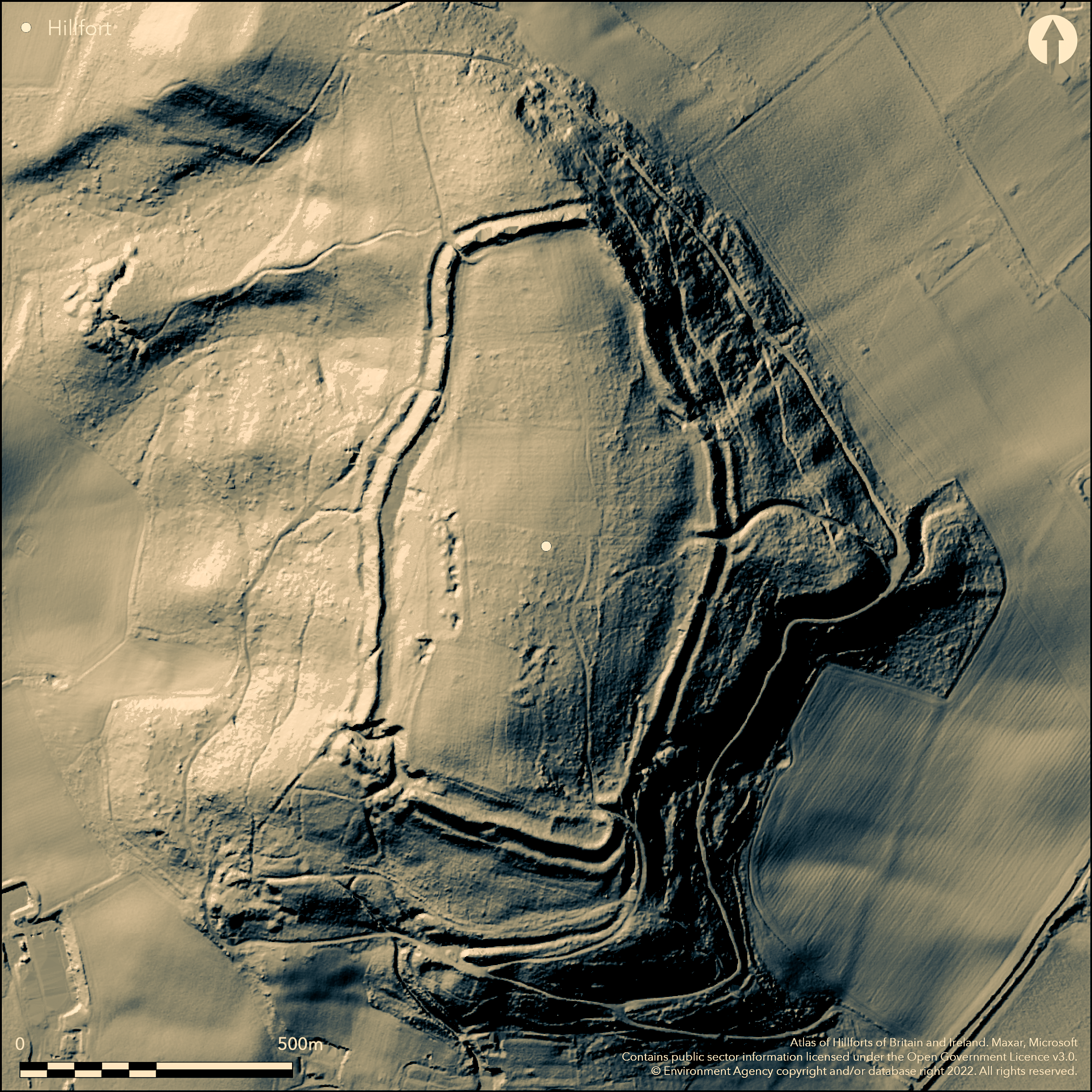
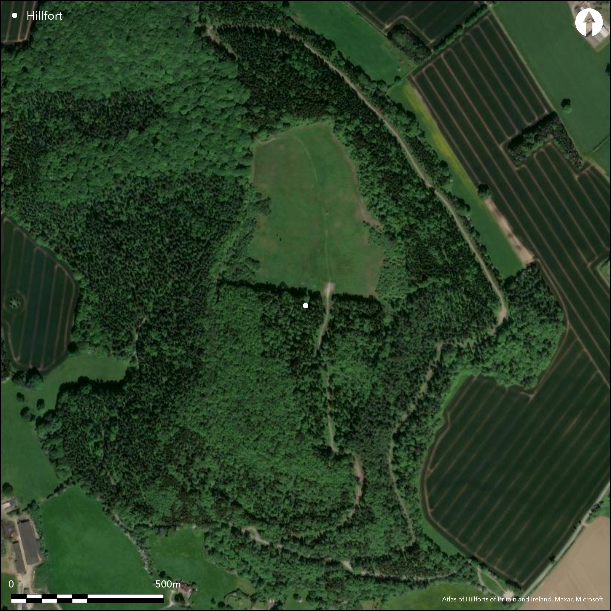
Very large, bivallate, contour hillfort located on steep hill within Credenhill Park Wood and dominating a major bend in the River Wye. Twice as large as any other in Herefordshire, enclosing 20ha. Substantial ramparts and ditch, the inner rampart (to 9m) higher than the outer (to 4m), with medial ditch. The height of the S rampart is augmented by scarping the natural hillslope to give a sense of monumentality, with a berm along the base of the scarp. The wide bank noted as a possible rampart was shown by excavation to be a lynchet or headland of the medieval cultivation of the interior. Two entrances (corner of SE and mid E), with inturns to give long approach passages, possibly with guard chambers. Possible SW entrance destroyed by quarrying. There are internal quarry scoops around much of the circuit, some used as ponds. Stanford's excavations, behind rampart S of E gate before site afforested, important in being the first published discussion of a defended settlement where the buildings appear to have been regularly spaced rectangular structures, here 8m from centre to centre. Postholes for corner posts of two sizes - 2.5m sq and 2.5m by 3.5m. Most rebuilt to the same plan six times. Probably four-posters, although Stanford dubiously postulated dwellings and the site holding 4,000 people and the political capital of the region. Pits thought late by Stanford, one at least, containing Romano-British pottery (Stanford 1970, 116). Recent excavations and topographical survey. Site initially planted with tree in the 1960's. Heavily wooded, but in 2008/2009 whole of N half of the site clear felled. Woodland management by the Woodland Trust continues. Part pasture in the interior. Referred to by Stukeley and on 1st Ed. OS map (1888).
Citizen Science: ✗
Reliability of Data: Confirmed
Reliability of Interpretation: Confirmed
X: -312013 Y: 6817677 (EPSG: 3857)
Longitude: -2.8028622748502023 Latitude: 52.09696681324768 (EPSG:4326)
Country: England
Current County or Unitary Authority: Herefordshire
Historic County: Herefordshire
Current Parish/Community/Council/Townland: Credenhill
SW corner totally destroyed by quarrying and extensive linear quarries in the interior. Recreation pressures now being addressed. Animal damage. Many paths.
| Extant | ✓ |
| Cropmark | ✗ |
| Likely Destroyed | ✓ |
Site initially planted with tree in the 1960's. Heavily wooded, but in 2008/2009 whole of N half of the site clear felled. Woodland management by the Woodland Trust continues. Part pasture in the interior. Quarries.
| Woodland | ✓ |
| Commercial Forestry Plantation | ✗ |
| Parkland | ✗ |
| Pasture (Grazing) | ✓ |
| Arable | ✗ |
| Scrub/Bracken | ✓ |
| Bare Outcrop | ✗ |
| Heather/Moorland | ✗ |
| Heath | ✗ |
| Built-up | ✗ |
| Coastal Grassland | ✗ |
| Other | ✓ |
Large contour hillfort. Located on steep and prominent hill within Credenhill Park Wood dominating a major bend in the River Wye.
| Contour Fort | ✓ |
| Partial Contour Fort | ✗ |
| Promontory Fort | ✗ |
| Hillslope Fort | ✗ |
| Level Terrain Fort | ✗ |
| Marsh Fort | ✗ |
| Multiple Enclosure Fort | ✗ |
| Hilltop | ✓ |
| Coastal Promontory | ✗ |
| Inland Promontory | ✗ |
| Valley Bottom | ✗ |
| Knoll/Hillock/Outcrop | ✗ |
| Ridge | ✗ |
| Cliff/Plateau-edge/Scarp | ✗ |
| Hillslope | ✗ |
| Lowland | ✗ |
| Spur | ✗ |
Dominant Topographic Feature: Prominent hill.
| North | ✗ |
| Northeast | ✗ |
| East | ✗ |
| Southeast | ✗ |
| South | ✗ |
| Southwest | ✗ |
| West | ✗ |
| Northwest | ✗ |
| Level | ✓ |
Altitude: 210.0m
N/A
First construction circa 390 BC, occupation ending AD 60, agreeing with evidence from Croft Ambrey. Romano-British sherds found by Stanford.
Reliability: B - Medium
| Pre 1200BC | ✗ |
| 1200BC - 800BC | ✗ |
| 800BC - 400BC | ✗ |
| 400BC - AD50 | ✓ |
| AD50 - AD400 | ✓ |
| AD400 - AD 800 | ✗ |
| Post AD800 | ✗ |
| Unknown | ✗ |
| Pre Hillfort: | None |
| Post Hillfort: | None |
| Artefactual: | Romano-British sherds found by Stanford. Bronze Age sherd. |
In Aubrey's Monumenta Britannica (1665-1693). On 1st Ed. OS map (1888). Excavations by S. Stanford 1963. Field survey 2003. Small excavations 2007-09. Small excavations in 2009-20011 Cambridge Archaeological Unit. Topographical survey by Herefordshire Archaeology 2008? Reports awaited. Herefordshire Council survey 2012.
| 1st Identified Map Depiction (1888): | OS map |
| Excavation (1963): | Excavation by S. Stanford. |
| Other (2003): | Field survey. |
| Other (2012): | Herefordshire Council survey. |
| 1st Identified Written Reference (None): | Aubrey's Monumenta Britannica. |
| Other (None): | Small excavations. |
| Earthwork Survey (None): | Herefordshire Archaeology topographical survey. |
| Excavation (None): | Small excavations Cambridge Archaeological Unit. |
Quarry hollows on surface. Excavation showed timber granaries, thought by Stanford to be habitation, similar to those found on the Wrekin, Croft Ambrey and Midsummer Hill.
Stream located 0.6km outside fort. Quarry scoops could have acted as ponds in places.
| None | ✓ |
| Spring | ✗ |
| Stream | ✗ |
| Pool | ✗ |
| Flush | ✗ |
| Well | ✗ |
| Other | ✓ |
There are internal quarry scoops around much of the circuit, some used as ponds. Heavy woodland hampers evaluation
| No Known Features | ✗ |
| Round Stone Structures | ✗ |
| Rectangular Stone Structures | ✗ |
| Curvilinear Platforms | ✗ |
| Other Roundhouse Evidence | ✗ |
| Pits | ✗ |
| Quarry Hollows | ✓ |
| Other | ✗ |
Evidence of timber granaries found. Postholes for corner posts of two sizes - 2.5m sq and 2.5m by 3.5m. Most rebuilt to the same plan six times. Probably four-posters, although Stanford postulated dwellings and the site holding 4,000 people and the political capital of the region. Pits thought late by Stanford, one at least, containing Romano-British pottery (Stanford 1970, 116).
| No Known Excavation | ✗ |
| Pits | ✓ |
| Postholes | ✓ |
| Roundhouses | ✗ |
| Rectangular Structures | ✓ |
| Roads/Tracks | ✗ |
| Quarry Hollows | ✓ |
| Other | ✗ |
| Nothing Found | ✗ |
Details of 2008 investigation awaited.
| No Known Geophysics | ✓ |
| Pits | ✗ |
| Roundhouses | ✗ |
| Rectangular Structures | ✗ |
| Roads/Tracks | ✗ |
| Quarry Hollows | ✗ |
| Other | ✗ |
| Nothing Found | ✗ |
Romano-British sherds found by Stanford.
| No Known Finds | ✗ |
| Pottery | ✓ |
| Metal | ✗ |
| Metalworking | ✗ |
| Human Bones | ✗ |
| Animal Bones | ✗ |
| Lithics | ✗ |
| Environmental | ✗ |
| Other | ✗ |
None
| APs Not Checked | ✓ |
| None | ✗ |
| Roundhouses | ✗ |
| Rectangular Structures | ✗ |
| Pits | ✗ |
| Postholes | ✗ |
| Roads/Tracks | ✗ |
| Other | ✗ |
Two entrances (corner of SE and mid E), with inturns to give long approach passages, possibly with guard chambers. Possible SW entrance destroyed by quarrying.
| 3: | Break in bank to N modern. |
| 2: | Two entrances (corner of SE and mid E), with inturns to give long approach passages, possibly with guard chambers. |
Guard Chambers: ✓
Chevaux de Frise: ✗
| 1. In-turned (South east): | Long approach passage with inturns and possible guard cahmbers. |
| 1. Passage-way/Corridor (South east): | Long passageway. |
| 1. Recesses/Guard Chambers (South east): | Possible guard chambers. |
| 2. In-turned (East): | Long approach passage with inturns and possible guard chambers. |
| 2. Passage-way/Corridor (East): | Long passageway. |
| 2. Recesses/Guard Chambers (East): | Possible guard chambers. |
Substantial ramparts and ditch, the inner rampart (to 9m) higher than the outer (to 4m), with medial ditch. The height of the S rampart is augmented by scarping the natural hillslope with a berm along the base of the scarp. The detail is lost in places and exact nature not determined.
| Area 1: | 20.0ha. |
| Total: | 20.0ha. |
Total Footprint Area: Noneha.
None
| ✗ | The largest hillfort in Herefordshire. |
| ✓ | Variable ramparts around circuit. |
| NE Quadrant: | 2 |
| SE Quadrant: | 2 |
| SW Quadrant: | 2 |
| NW Quadrant: | 2 |
| Total: | 2 |
| Partial Univallate | ✗ |
| Univallate | ✗ |
| Partial Bivallate | ✗ |
| Bivallate | ✓ |
| Partial Multivallate | ✗ |
| Multivallate | ✗ |
| Unknown | ✗ |
| Partial Univallate | ✗ |
| Univallate | ✗ |
| Partial Bivallate | ✗ |
| Bivallate | ✗ |
| Partial Multivallate | ✗ |
| Multivallate | ✗ |
Berm to S rampart.
| None | ✗ |
| Earthen Bank | ✓ |
| Stone Wall | ✗ |
| Rubble | ✗ |
| Wall-walk | ✗ |
| Evidence of Timber | ✗ |
| Vitrification | ✗ |
| Other Burning | ✗ |
| Palisade | ✗ |
| Counter Scarp Bank | ✗ |
| Berm | ✓ |
| Unfinished | ✗ |
| Other | ✗ |
The wide bank noted as a possible rampart was shown by excavation to be a lynchet or headland of the medieval cultivation of the interior. Details of 2008 investigation awaited.
| None | ✗ |
| Earthen Bank | ✓ |
| Stone Wall | ✗ |
| Murus Duplex | ✗ |
| Timber-framed | ✗ |
| Timber-laced | ✗ |
| Vitrification | ✗ |
| Other Burning | ✗ |
| Palisade | ✗ |
| Counter Scarp Bank | ✗ |
| Berm | ✗ |
| Unfinished | ✗ |
| No Known Excavation | ✗ |
| Other | ✗ |
| ✗ | None |
| ✓ | Medial ditches, their detail to be determined. |
Number of Ditches: 2
| ✗ | None |
Boucher, A. and Eisel, J. 2004. Park Wood Credenhill Archaeological Survey, Herefordshire: Archaeological Landscape Survey and Site Assessment, Archaeological Investigations Ltd. 595.
Dorling, P. and Wigley, A. 2012: Assessment of the archaeological and conservation status of major later prehistoric enclosures in Herefordshire and Shropshire, EH PNUM, Version 3.2, Hereford and Shrewsbury: Herefordshire Council/Shropshire Council.
Page, W. ed. 1908. The Victoria County History of the County of Herefordshire, 1, 206-7, London: St Catherine Press.
RCHME 1931-34. An Inventory of the Historical Monuments in Herefordshire, 2 (E), 65, 6, London: HMSO.
Stanford, S.C. 1970. Credenhill Camp, Herefordshire, an Iron-Age hillfort capital, Archaeol J, CXXVII, 82-129.
Atlas of Hillforts:
Wikidata:
This work is licensed under CC BY-SA 4.0![]()
![]()
![]() and should be cited as:
and should be cited as:
Lock, Gary and Ralston, Ian. 2024. Atlas of Hillforts of Britain and Ireland. Available at: https://hillforts.arch.ox.ac.uk
Document Version 1.1