LiDAR 1m DTM Hillshade
Satellite Imagery
LiDAR 1m DTM Hillshade
Satellite Imagery
Scroll left/right to view further images.
HER: Herefordshire MHE11 (177)
NMR: SO 46 NW 1 (108422)
SM: 1001750
NGR: SO 444668
X: 344400 Y: 266800 (OSGB36)
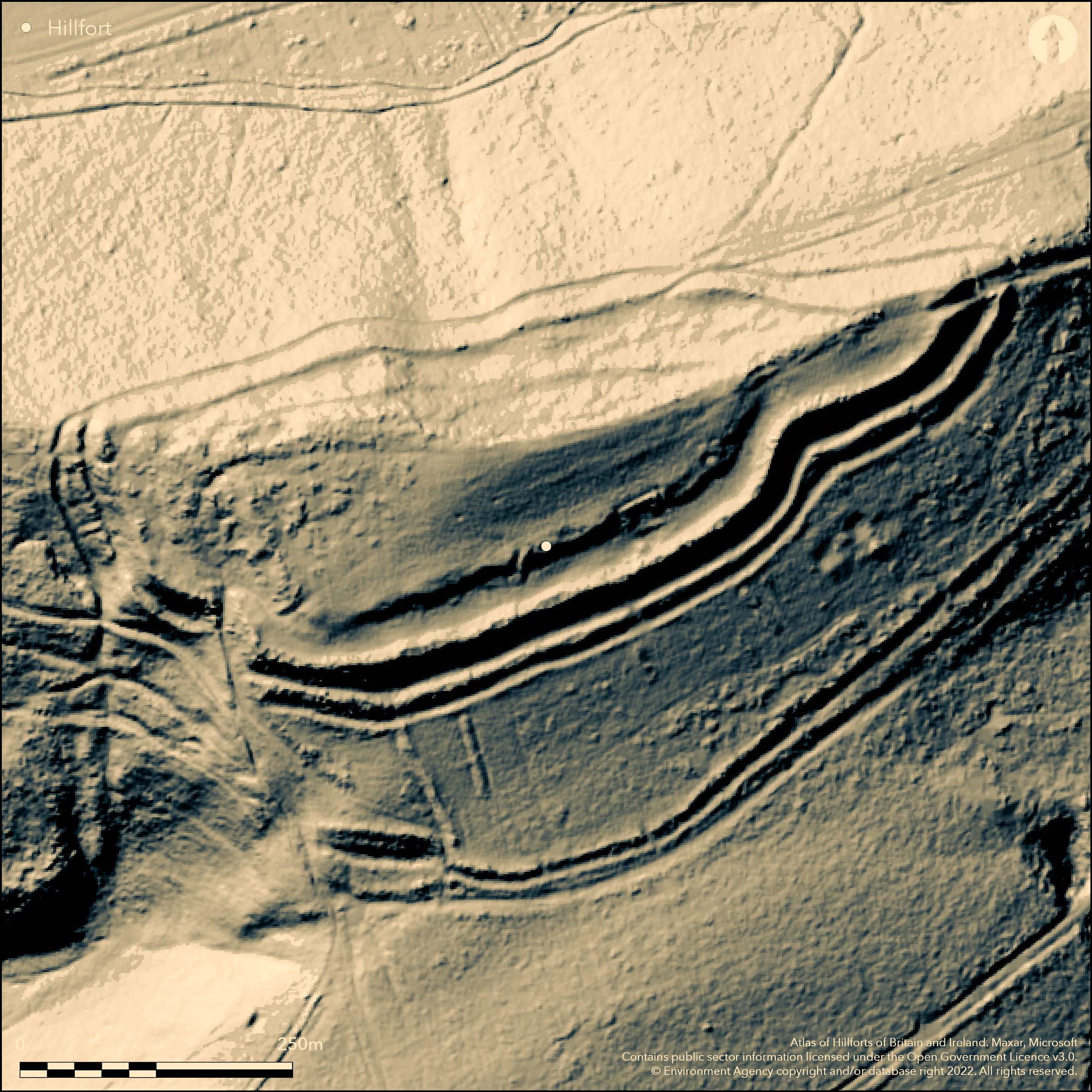
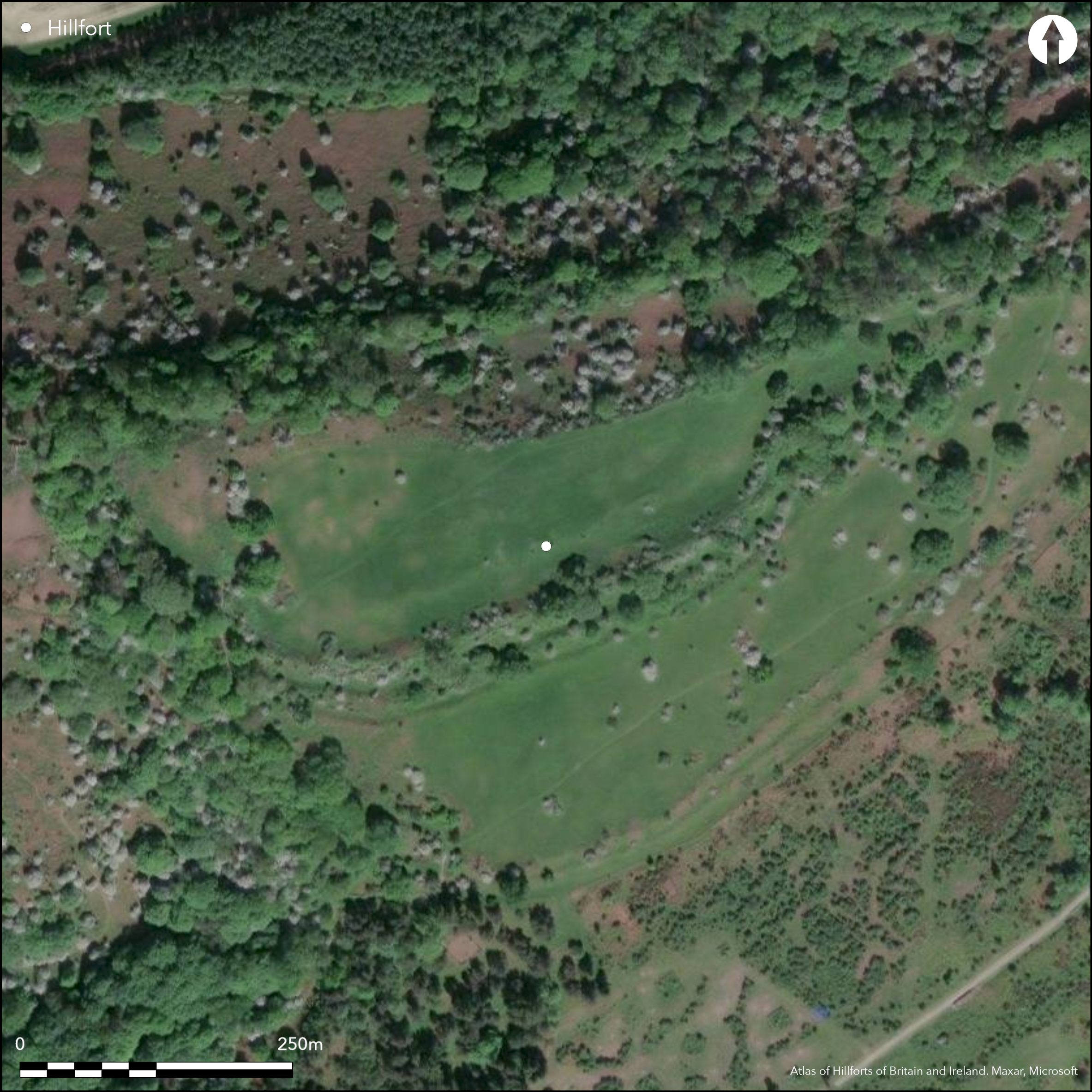
Fine partial contour hillfort sited above wooded slopes of significant bend of River Lugg dominating the Leintwardine Fishery. Very steep and steep slopes to E, W and N, moderate to S. Roughly D-shaped, with internal area c. 3.6ha. Three substantial banks and ditches complete circuit. Gates and part of interior and annexe famously excavated by Stanford 1960-66. Phased construction and seven periods of occupation suggested between 450 BC to AD 49 on the evidence of gateway renewal. Firstly a rampart (later removed) and ditch (still visible) enclosing 2.2ha. Rows of possibly four-posters for grain storage, thought by Stanford as rows of dwellings. Some evidence of pits, but of the 14 excavated most less than 1m deep, and only four of depth suitable for grain storage. At least five and possibly seven periods of modification/reconstruction, though ten have been suggested at the SW gate, with 20 series of postholes over time. C. 390 BC bank levelled and new enclosure built of 4ha visible as the inner rampart and two external banks and ditches. Later an annexe was added to the S, defined by two weak banks and ditches, to give a total footprint of c. 8.4ha. Intensive occupation to c. 49 BC when the Romans took the fort. C. 2nd century AD a 'mound' was constructed in the annexe, possibly an arena for gatherings and sacrifice/shrine, or indeed a representation of a Romano-Celtic temple or sanctuary. There are two main original entrances identified, that to the SW is complex winding through a series of outworks with hollow way and narrow path into the interior. The second entrance, at the NE corner, is protected by a turning of the two inner ramparts and mounds on the edge of the steep natural scarp. Suggested postern entrance on the W is probably modern. Well-preserved, public access, National Trust site, but bracken problem. On 1st Ed. OS map (1885-1900).
Citizen Science: ✗
Reliability of Data: Confirmed
Reliability of Interpretation: Confirmed
X: -313557 Y: 6853909 (EPSG: 3857)
Longitude: -2.816729681078883 Latitude: 52.296467412766525 (EPSG:4326)
Country: England
Current County or Unitary Authority: Herefordshire
Historic County: Herefordshire
Current Parish/Community/Council/Townland: Aymestry
Good condition, with management by the National Trust. Recreation pressure generally managed despite no full management plan and wind-throw of scattered trees could be a problem. Repair and re-routing of access path through W entrance.
| Extant | ✓ |
| Cropmark | ✗ |
| Likely Destroyed | ✗ |
Bracken can be a problem for interpretation during the summer and control carried out.
| Woodland | ✗ |
| Commercial Forestry Plantation | ✗ |
| Parkland | ✗ |
| Pasture (Grazing) | ✗ |
| Arable | ✗ |
| Scrub/Bracken | ✓ |
| Bare Outcrop | ✗ |
| Heather/Moorland | ✗ |
| Heath | ✓ |
| Built-up | ✗ |
| Coastal Grassland | ✗ |
| Other | ✗ |
The fort partly follows the contours. Sited on a spur above a significant bend of the River Lugg dominating the Leintwardine Fishery.
| Contour Fort | ✗ |
| Partial Contour Fort | ✓ |
| Promontory Fort | ✗ |
| Hillslope Fort | ✗ |
| Level Terrain Fort | ✗ |
| Marsh Fort | ✗ |
| Multiple Enclosure Fort | ✗ |
| Hilltop | ✓ |
| Coastal Promontory | ✗ |
| Inland Promontory | ✗ |
| Valley Bottom | ✗ |
| Knoll/Hillock/Outcrop | ✗ |
| Ridge | ✗ |
| Cliff/Plateau-edge/Scarp | ✗ |
| Hillslope | ✗ |
| Lowland | ✗ |
| Spur | ✗ |
Dominant Topographic Feature: Spur above the River Lugg.
| North | ✗ |
| Northeast | ✗ |
| East | ✗ |
| Southeast | ✗ |
| South | ✗ |
| Southwest | ✓ |
| West | ✗ |
| Northwest | ✗ |
| Level | ✗ |
Altitude: 295.0m
N/A
Stanford suggested seven periods of occupation, as a result of the renewal of the gates, between 450 BC to AD 49. Firstly a rampart (later removed) and ditch (still visible) enclosing 2.2ha. Rows of possibly four-posters for grain storage. At least five periods of modification/reconstruction. C. 390 BC bank levelled and new enclosure built of 4ha visible as the inner rampart and two external banks and ditches. Later an annexe was added to the S, defined by two weak banks and ditches. The mound, which was fully excavated, was of late Roman date, built over an initial early Roman terrace. Here coarse ware predominated, but also included some Samian ware. Iron Age metal-ware found. C14 dating from the excavation appears problematical as vast range between 1700-750 cal BC.
Reliability: B - Medium
| Pre 1200BC | ✗ |
| 1200BC - 800BC | ✗ |
| 800BC - 400BC | ✗ |
| 400BC - AD50 | ✓ |
| AD50 - AD400 | ✓ |
| AD400 - AD 800 | ✓ |
| Post AD800 | ✗ |
| Unknown | ✗ |
| Pre Hillfort: | None |
| Post Hillfort: | None |
| Artefactual: | Iron Age pottery from the main enclosure. Coarse ware predominated in the annexe, but also included some Samian ware. |
| Artefactual: | Triskele pendants found. |
| C14: | Stanford - problematic as vast range 1700 BC to 750 BC? |
| Morphology/Earthwork/Typology: | Stanford suggested seven periods of occupation as a result of the renewal of the gates. |
In Aubrey's Monumenta Britannica (1665-1693). On 1st Ed. OS map (1885-1900). Excavations between 1960-66 by the Woolhope Naturalist's Field Club under the direction of S.C. Stanford, excavation report published privately 1974. Herefordshire Council survey 2012.
| Other (1968): | Visit by Hillfort Study Group |
| Other (2012): | Herefordshire Council survey. |
| 1st Identified Written Reference (None): | Aubrey's Monumenta Britannica. |
| 1st Identified Map Depiction (None): | OS map. |
| Excavation (None): | Excavations between 1960-66 by the Woolhope Naturalist's Field Club under the direction of S.C. Stanford. |
Rows of possibly four-posters for grain storage a feature of the excavations. Pit evidence found by excavation (14 pits) in the main enclosure. Most only to just over 1m deep.At least five periods of modification/reconstruction. Terrace and mound constructed in the annexe in the Roman period. Two medieval pillow mounds in the annexe. Platforms protected by drainage hoods on the N side of the quarry ditch. Iron Age and Roman pottery, metal-ware and bone found with many other finds in the excavations.
Stream located 0.5 km outside the hillfort.
| None | ✓ |
| Spring | ✗ |
| Stream | ✗ |
| Pool | ✗ |
| Flush | ✗ |
| Well | ✗ |
| Other | ✗ |
Terrace and mound constructed in the annexe in the Roman period. Two medieval pillow mounds in the annexe. Platforms protected by drainage hoods on the N side of the quarry ditch. terraces cut into the N-facing hillside.
| No Known Features | ✗ |
| Round Stone Structures | ✗ |
| Rectangular Stone Structures | ✗ |
| Curvilinear Platforms | ✓ |
| Other Roundhouse Evidence | ✗ |
| Pits | ✗ |
| Quarry Hollows | ✓ |
| Other | ✓ |
Rows of four-post structures and pit evidence found by excavation (14 pits) in the main enclosure. Most less than 1m deep. Some contained burnt clay and grain (carbonised wheat), but only four of suitable depth for grain storage. A Roman terrace and squarish mound found in the annexe. Further detail from the fine excavation report.
| No Known Excavation | ✗ |
| Pits | ✓ |
| Postholes | ✓ |
| Roundhouses | ✗ |
| Rectangular Structures | ✓ |
| Roads/Tracks | ✗ |
| Quarry Hollows | ✓ |
| Other | ✓ |
| Nothing Found | ✗ |
None
| No Known Geophysics | ✓ |
| Pits | ✗ |
| Roundhouses | ✗ |
| Rectangular Structures | ✗ |
| Roads/Tracks | ✗ |
| Quarry Hollows | ✗ |
| Other | ✗ |
| Nothing Found | ✗ |
Many finds including Iron Age and Roman pottery (Malvernian ware, VCP and others), gold, bronze, shale and glass ornaments, slag, furnace lining and ore, clay and limestone loom weights, querns and animal and human bone. Charcoal. Bronze Age sherd.
| No Known Finds | ✗ |
| Pottery | ✓ |
| Metal | ✓ |
| Metalworking | ✓ |
| Human Bones | ✓ |
| Animal Bones | ✓ |
| Lithics | ✓ |
| Environmental | ✗ |
| Other | ✓ |
None
| APs Not Checked | ✓ |
| None | ✗ |
| Roundhouses | ✗ |
| Rectangular Structures | ✗ |
| Pits | ✗ |
| Postholes | ✗ |
| Roads/Tracks | ✗ |
| Other | ✗ |
In first phase entrances to the E and W. Circa 390 BC new NE gate constructed and added on SW. Hollow way to the NE forms the approach to the fort with complex series of outworks. The NE entrance flanked by turning of the two inner ramparts and three mounds on the edge of the steep natural scarp. SW gap now main public entrance. Suggested postern entrance on the W is probably modern.
| 2: | Main entrance for public now directed though SW entrance. Suggested postern entrance on the W is probably modern. |
| 2: | In first phase entrances to the E and W. Circa 390 BC new NE gate constructed and added on SW. Hollow way to the NE forms the approach to the fort. |
Guard Chambers: ✓
Chevaux de Frise: ✗
| 1. Simple Gap (South west): | Now main public entrance. |
| 2. Hollow Way (North east): | Hollow way forms approach to fort. |
| 2. In-turned (North east): | Two inner ramparts turned and three mounds, guard chambers. |
| 2. Outworks (North east): | Complicated series of outworks. |
Three ramparts and deep ditches define the site. Main rampart c. 10m above the external ditch with two lesser outer banks, the most S suggested as incomplete.
| Area 1: | 2.2ha. |
| Area 2: | 3.6ha. |
| Total: | 3.6ha. |
Total Footprint Area: 8.4ha.
None
| ✓ | Phased construction and seven periods of occupation suggested between 450 BC to AD 49 on the evidence of gateway renewal. Firstly a rampart (later removed) and ditch (still visible) enclosing 2.2ha. Rows of possibly four-posters for grain storage. At least five periods of modification/reconstruction. Circa 390 BC bank levelled and new enclosure built of 3.6a visible as the inner rampart and two external banks and ditches. Later an annexe was added to the S, defined by two weak banks and ditches. The mound in the annexe proved to be Roman. |
| ✓ | Three ramparts complete the circuit. |
| NE Quadrant: | 3 |
| SE Quadrant: | 3 |
| SW Quadrant: | 3 |
| NW Quadrant: | 3 |
| Total: | 3 |
| Partial Univallate | ✗ |
| Univallate | ✗ |
| Partial Bivallate | ✗ |
| Bivallate | ✗ |
| Partial Multivallate | ✗ |
| Multivallate | ✓ |
| Unknown | ✗ |
| Partial Univallate | ✗ |
| Univallate | ✓ |
| Partial Bivallate | ✗ |
| Bivallate | ✗ |
| Partial Multivallate | ✗ |
| Multivallate | ✗ |
It has been suggested that the most S of the two lesser outer banks is incomplete.
| None | ✗ |
| Earthen Bank | ✓ |
| Stone Wall | ✗ |
| Rubble | ✗ |
| Wall-walk | ✗ |
| Evidence of Timber | ✗ |
| Vitrification | ✗ |
| Other Burning | ✗ |
| Palisade | ✗ |
| Counter Scarp Bank | ✗ |
| Berm | ✗ |
| Unfinished | ✓ |
| Other | ✗ |
Detail is outlined in the summary.
| None | ✗ |
| Earthen Bank | ✓ |
| Stone Wall | ✓ |
| Murus Duplex | ✗ |
| Timber-framed | ✗ |
| Timber-laced | ✗ |
| Vitrification | ✗ |
| Other Burning | ✗ |
| Palisade | ✗ |
| Counter Scarp Bank | ✗ |
| Berm | ✗ |
| Unfinished | ✗ |
| No Known Excavation | ✗ |
| Other | ✗ |
| ✗ | None |
| ✓ | The external ditch is up to 10m below the main rampart. |
Number of Ditches: 3
| ✓ | Large entrance located on the S of the main enclosure with two weak banks that get smaller as they turn N. Within the annexe of c. 4.8ha Stanford found an early Roman terrace, followed by a squarish mound which had clearly been used for animal sacrifice and which has been suggested as a possible Romano-British temple. |
Darvill, T. Stamper, P. and Timby, J. 2000. England an archaeological guide, 202-3, Oxford: OUP.
Dorling, P. and Wigley, A. 2012: Assessment of the archaeological and conservation status of major later prehistoric enclosures in Herefordshire and Shropshire, EH PNUM, Version 3.2, Hereford and Shrewsbury: Herefordshire Council/Shropshire Council.
Field, D, Smith, N. 2008. Croft Ambrey, Aymestrey, Herefordshire. Analysis of earthworks, Archaeological Survey Report, Swindon: English Heritage.
Stanford, S. 1974. Croft Ambrey, Leominster: Privately published.
Atlas of Hillforts:
Wikidata:
This work is licensed under CC BY-SA 4.0![]()
![]()
![]() and should be cited as:
and should be cited as:
Lock, Gary and Ralston, Ian. 2024. Atlas of Hillforts of Britain and Ireland. Available at: https://hillforts.arch.ox.ac.uk
Document Version 1.1