LiDAR 1m DTM Hillshade
Satellite Imagery
LiDAR 1m DTM Hillshade
Satellite Imagery
Scroll left/right to view further images.
HER: Herefordshire MHE657 (1278)
NMR: SO 53 NW 16 (110220)
SM: 1001758
NGR: SO 523363
X: 352360 Y: 236350 (OSGB36)
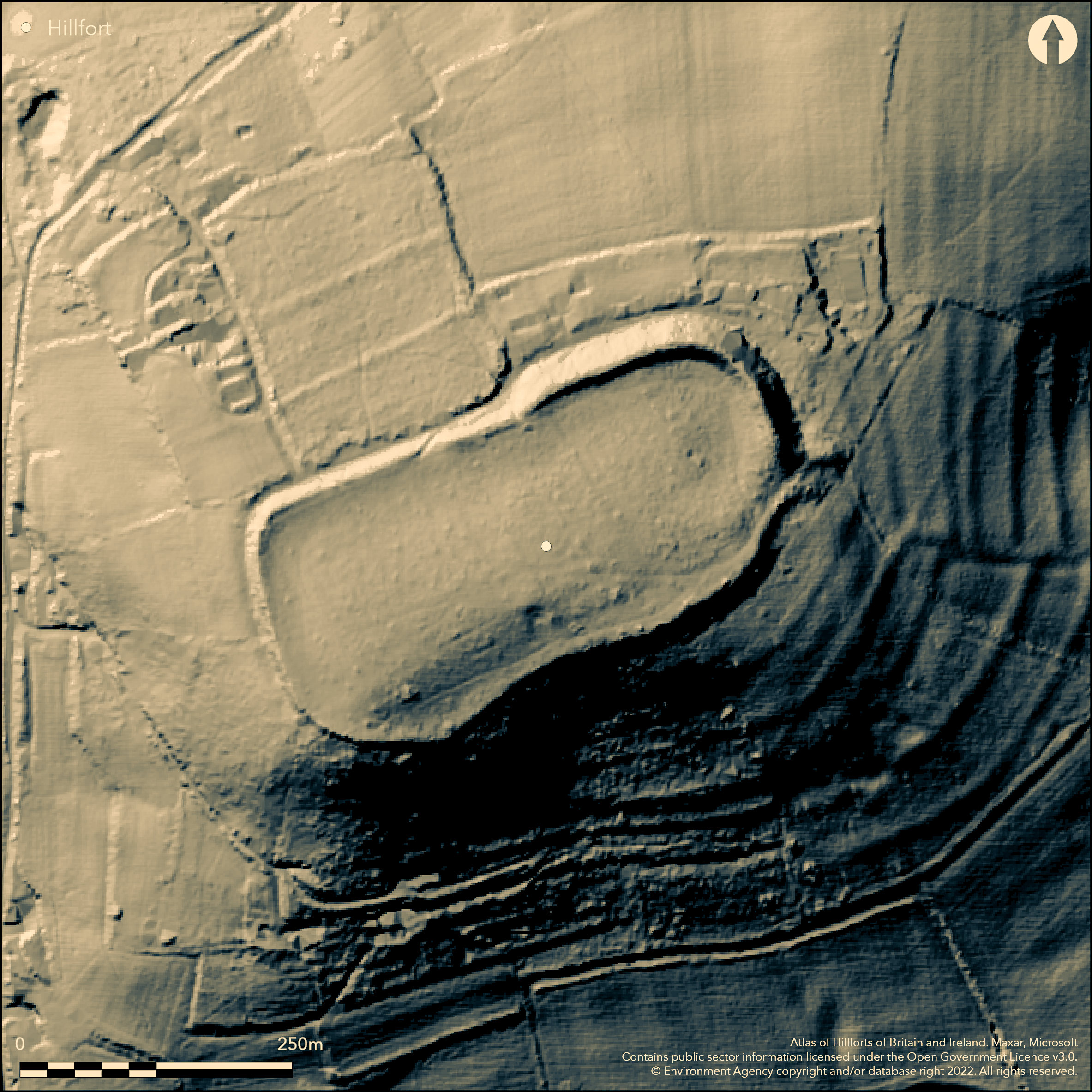
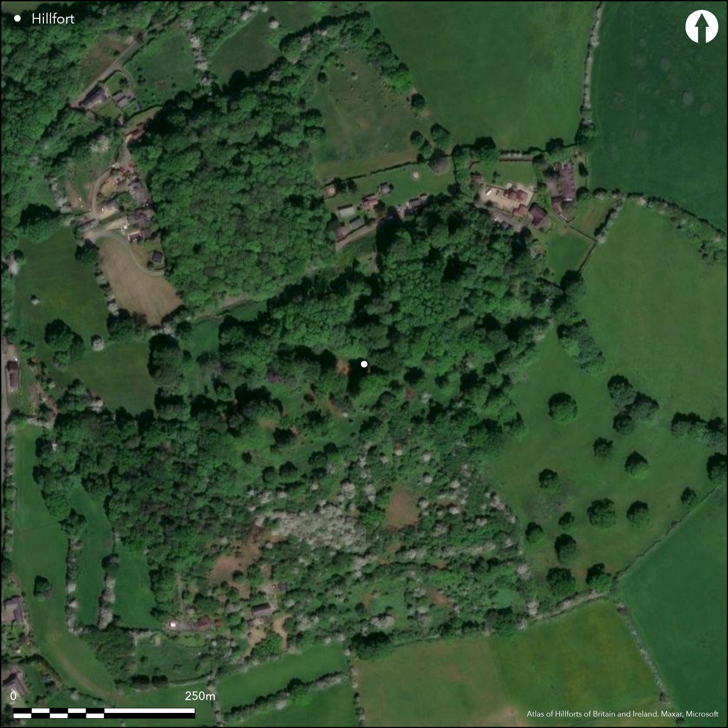
Oval, contour hillfort located on the summit of Dinedor Hill overlooking the River Wye and Hereford and its confluence with the River Lugg and the confluence of the Lugg and Frome. On NE side high bank to c. 8m high, elsewhere less to 3m, with ditch remnants. Scarp and berm on NW and W sides. Defended by natural slope on most of the S side. Both side of the rampart may have been revetted in stone. No evidence of ditch, but one probably existed and watching brief in 1998 may have determined this. Small excavation by Kenyon found dense occupation behind the rampart, with Iron Age to Roman pottery and coins. Only entrance on the SE corner, out-turned and elongated. Site may have been occupied in 1645 by Scottish troops as part of the Siege of Hereford, with possible hornwork and bastion alterations. Heavily wooded ramparts, but now the subject of a substantial management plan and agreement. Sapling, scrub and brambles managed. Interior part wood part pasture. Generally improving condition. On 1st Ed. OS map (1888).
Citizen Science: ✗
Reliability of Data: Confirmed
Reliability of Interpretation: Confirmed
X: -300088 Y: 6804371 (EPSG: 3857)
Longitude: -2.695736032042048 Latitude: 52.02347235314936 (EPSG:4326)
Country: England
Current County or Unitary Authority: Herefordshire
Historic County: Herefordshire
Current Parish/Community/Council/Townland: Dinedor
Wooded with beech wind-throw problems as a result of mature beech trees, some removed in 2007-2008. Generally improving in condition.
| Extant | ✓ |
| Cropmark | ✗ |
| Likely Destroyed | ✗ |
Heavily wooded ramparts, but now the subject of a substantial management plan and agreement. Sapling, scrub and brambles managed. Interior part wood part pasture.
| Woodland | ✓ |
| Commercial Forestry Plantation | ✗ |
| Parkland | ✗ |
| Pasture (Grazing) | ✓ |
| Arable | ✗ |
| Scrub/Bracken | ✓ |
| Bare Outcrop | ✗ |
| Heather/Moorland | ✗ |
| Heath | ✗ |
| Built-up | ✗ |
| Coastal Grassland | ✗ |
| Other | ✗ |
Important contour hillfort located on the summit of Dinedor Hill overlooking the River Wye and Hereford and its confluence with the River Lugg and the confluence of the Lugg and Frome.
| Contour Fort | ✓ |
| Partial Contour Fort | ✗ |
| Promontory Fort | ✗ |
| Hillslope Fort | ✗ |
| Level Terrain Fort | ✗ |
| Marsh Fort | ✗ |
| Multiple Enclosure Fort | ✗ |
| Hilltop | ✓ |
| Coastal Promontory | ✗ |
| Inland Promontory | ✗ |
| Valley Bottom | ✗ |
| Knoll/Hillock/Outcrop | ✗ |
| Ridge | ✗ |
| Cliff/Plateau-edge/Scarp | ✗ |
| Hillslope | ✗ |
| Lowland | ✗ |
| Spur | ✗ |
Dominant Topographic Feature: Dinedor Hill.
| North | ✗ |
| Northeast | ✗ |
| East | ✗ |
| Southeast | ✗ |
| South | ✗ |
| Southwest | ✗ |
| West | ✗ |
| Northwest | ✗ |
| Level | ✓ |
Altitude: 182.0m
N/A
Iron Age stamped Malverian and vesicular mudstone tempered wares c. 2nd century BC. Romano-British pottery and Roman coins found of Galba AD 68-69 and Citellius could indicate some form of occupation/activity.
Reliability: B - Medium
| Pre 1200BC | ✓ |
| 1200BC - 800BC | ✗ |
| 800BC - 400BC | ✗ |
| 400BC - AD50 | ✓ |
| AD50 - AD400 | ✓ |
| AD400 - AD 800 | ✗ |
| Post AD800 | ✗ |
| Unknown | ✗ |
| Pre Hillfort: | None |
| Post Hillfort: | None |
| Artefactual: | Iron Age pottery. |
| Artefactual: | Neolithic polished axe; Iron age to Roman pottery; Roman coins. |
On 1st Ed. OS map (1885-1900). On 1st Ed. OS map (1888). Trial excavation in 1951 at rear of rampart at the NE corner, with a trench nearby to the top of the hill. Heavy occupation proved behind the rampart, but none at the top of the hill. Watching brief in 1998 on development to E of hillfort showed pit and shallow ditch with mid Iron Age pottery and Roman Severn Valley ware. Also possible outer edge of hillfort ditch. Herefordshire Council survey of 2012.
| 1st Identified Map Depiction (1888): | OS map |
| Excavation (1951): | At rear of rampart and trench to the top of the hill |
| Other (1998): | Watching brief east of hillfort. |
| Other (2012): | Herefordshire Council survey |
| 1st Identified Written Reference (None): | None |
Heavy occupation proved behind the ramparts as a result of the trial excavation, but none on the crest of the hill. Iron Age pottery, daub, bone, iron fragments, iron axehead and Roman sherds found. Also coins of Galba (AD 68-69) and Citellius. Watching brief on development to E of hillfort showed pit and shallow ditch with mid Iron Age pottery and Roman Severn Valley ware.
Stream located 0.5 km outside the fort.
| None | ✓ |
| Spring | ✗ |
| Stream | ✗ |
| Pool | ✗ |
| Flush | ✗ |
| Well | ✗ |
| Other | ✗ |
None
| No Known Features | ✓ |
| Round Stone Structures | ✗ |
| Rectangular Stone Structures | ✗ |
| Curvilinear Platforms | ✗ |
| Other Roundhouse Evidence | ✗ |
| Pits | ✗ |
| Quarry Hollows | ✗ |
| Other | ✗ |
Three successive floors found. Heavy occupation proved behind the ramparts as a result of the trial excavation, but none on the crest of the hill. Watching brief on development to E of hillfort showed pit and shallow ditch with mid Iron Age pottery and Roman Severn Valley ware.
| No Known Excavation | ✗ |
| Pits | ✓ |
| Postholes | ✗ |
| Roundhouses | ✗ |
| Rectangular Structures | ✗ |
| Roads/Tracks | ✗ |
| Quarry Hollows | ✗ |
| Other | ✓ |
| Nothing Found | ✗ |
None
| No Known Geophysics | ✓ |
| Pits | ✗ |
| Roundhouses | ✗ |
| Rectangular Structures | ✗ |
| Roads/Tracks | ✗ |
| Quarry Hollows | ✗ |
| Other | ✗ |
| Nothing Found | ✗ |
Iron Age pottery, daub, bone, iron fragments, iron axehead and Roman sherds found. Also coins of Galba (AD 68-69) and Citellius. Watching brief on development to E of hillfort showed pit and shallow ditch with mid Iron Age pottery and Roman Severn Valley ware.
| No Known Finds | ✗ |
| Pottery | ✓ |
| Metal | ✓ |
| Metalworking | ✗ |
| Human Bones | ✗ |
| Animal Bones | ✓ |
| Lithics | ✓ |
| Environmental | ✗ |
| Other | ✓ |
None
| APs Not Checked | ✓ |
| None | ✗ |
| Roundhouses | ✗ |
| Rectangular Structures | ✗ |
| Pits | ✗ |
| Postholes | ✗ |
| Roads/Tracks | ✗ |
| Other | ✗ |
SE slightly out-turned entrance, with traces of a bank or mound outside, giving a long passageway. Possible Civil War alterations. No other gaps in evidence.
| 1: | No modern gaps. |
| 2: | SE slightly out-turned entrance with traces of a bank or mound outside. Possible Civil War and modern alterations, including hornwork and bastian (not included in analysis). |
Guard Chambers: ✗
Chevaux de Frise: ✗
| 1. Out-turned (East): | SE slightly out-turned entrance with traces of a bank or mound outside giving a long passageway. Possible Civil War and modern alterations. |
| 1. Passage-way/Corridor (East): | Long passageway. |
On NE side high bank to c. 8m high, elsewhere less to 3m, with ditch remnants. Scarp and berm on N and W sides. Possible stone revetment found on inner face of rampart. Defended by natural slope on most of the S side.
| Area 1: | 3.9ha. |
| Total: | 3.9ha. |
Total Footprint Area: Noneha.
Defended by natural slope on most of the south side.
| ✗ | None |
| ✗ | S side defended by natural slope. |
| NE Quadrant: | 2 |
| SE Quadrant: | 1 |
| SW Quadrant: | 0 |
| NW Quadrant: | 2 |
| Total: | 2 |
| Partial Univallate | ✓ |
| Univallate | ✗ |
| Partial Bivallate | ✓ |
| Bivallate | ✗ |
| Partial Multivallate | ✗ |
| Multivallate | ✗ |
| Unknown | ✗ |
| Partial Univallate | ✗ |
| Univallate | ✗ |
| Partial Bivallate | ✗ |
| Bivallate | ✗ |
| Partial Multivallate | ✗ |
| Multivallate | ✗ |
Possible earthen bank, but rampart may have been revetted in stone. Scarp and berm on NW and W sides.
| None | ✗ |
| Earthen Bank | ✓ |
| Stone Wall | ✓ |
| Rubble | ✗ |
| Wall-walk | ✗ |
| Evidence of Timber | ✗ |
| Vitrification | ✗ |
| Other Burning | ✗ |
| Palisade | ✗ |
| Counter Scarp Bank | ✗ |
| Berm | ✓ |
| Unfinished | ✗ |
| Other | ✗ |
Possible stone revetment found on inner face of rampart.
| None | ✗ |
| Earthen Bank | ✗ |
| Stone Wall | ✓ |
| Murus Duplex | ✗ |
| Timber-framed | ✗ |
| Timber-laced | ✗ |
| Vitrification | ✗ |
| Other Burning | ✗ |
| Palisade | ✗ |
| Counter Scarp Bank | ✗ |
| Berm | ✗ |
| Unfinished | ✗ |
| No Known Excavation | ✗ |
| Other | ✗ |
| ✗ | None |
| ✓ | Watching brief on development to E of hillfort showed pit and shallow ditch. Possibly buried feature to fort. |
Number of Ditches: 1
| ✗ | None |
Dorling, P. and Wigley, A. 2012. Assessment of the archaeological and conservation status of major later prehistoric enclosures in Herefordshire and Shropshire, EH PNUM, Version 3.2, Hereford and Shrewsbury: Herefordshire Council/Shropshire Council.
Dorling, P. and Widdicombe, R. 2008. A conservation management plan for Dinedor Camp, Herefordshire. Hereford: Herefordshire Archaeology.
Page, W. ed. 1908. The Victoria County History of the County of Herefordshire, 1, 208-9, London: St Catherine Press.
RCHME 1931-34. An Inventory of the Historical Monuments in Herefordshire, 1(SW), 55, 6, London: HMSO.
Atlas of Hillforts:
Wikidata:
This work is licensed under CC BY-SA 4.0![]()
![]()
![]() and should be cited as:
and should be cited as:
Lock, Gary and Ralston, Ian. 2024. Atlas of Hillforts of Britain and Ireland. Available at: https://hillforts.arch.ox.ac.uk
Document Version 1.1