LiDAR 1m DTM Hillshade
Satellite Imagery
LiDAR 1m DTM Hillshade
Satellite Imagery
Scroll left/right to view further images.
HER: Herefordshire MHE434 (931); Worcestershire WSM00932
NMR: SO 73 NE 11 (113497)
SM: 1003533
NGR: SO 761374
X: 376100 Y: 237400 (OSGB36)
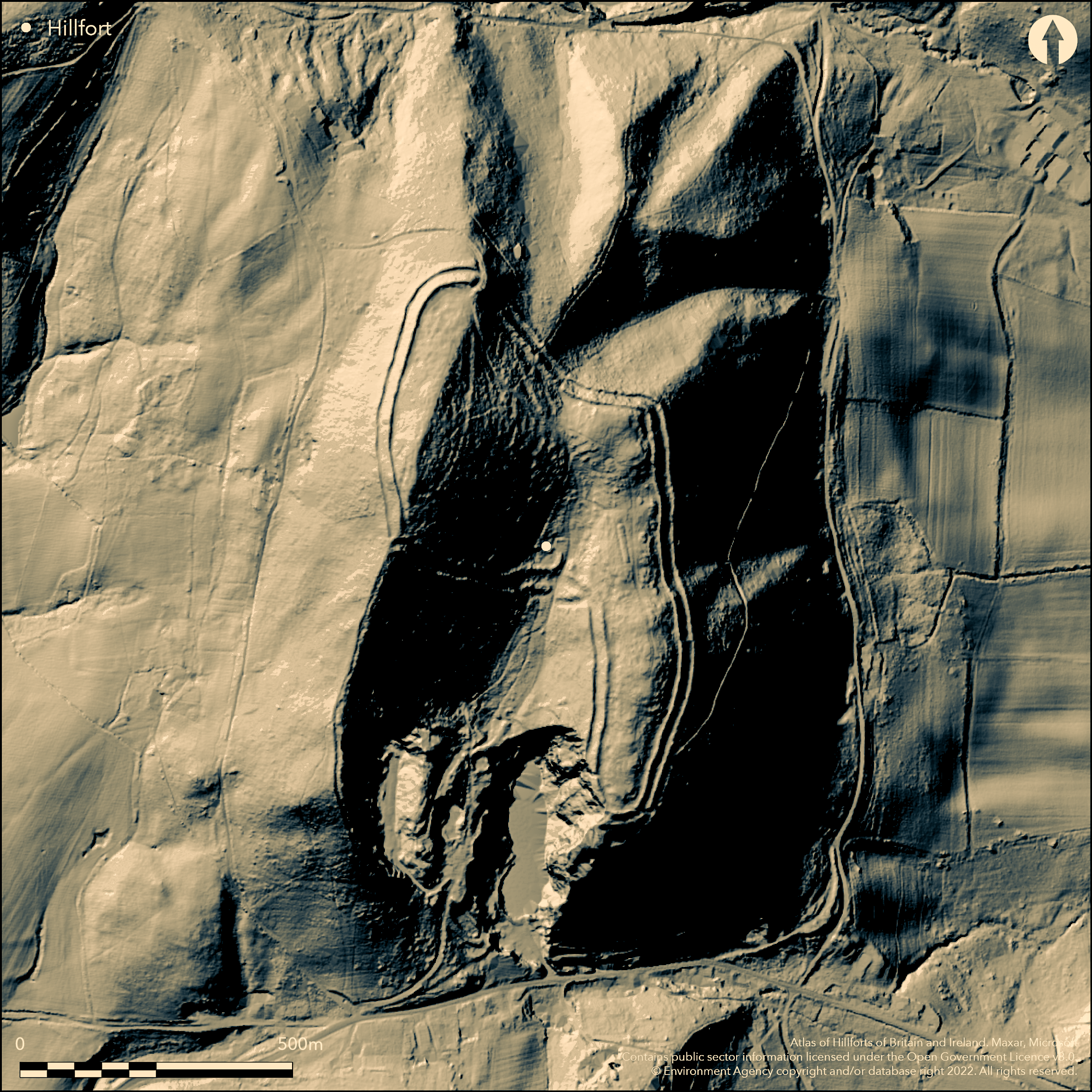
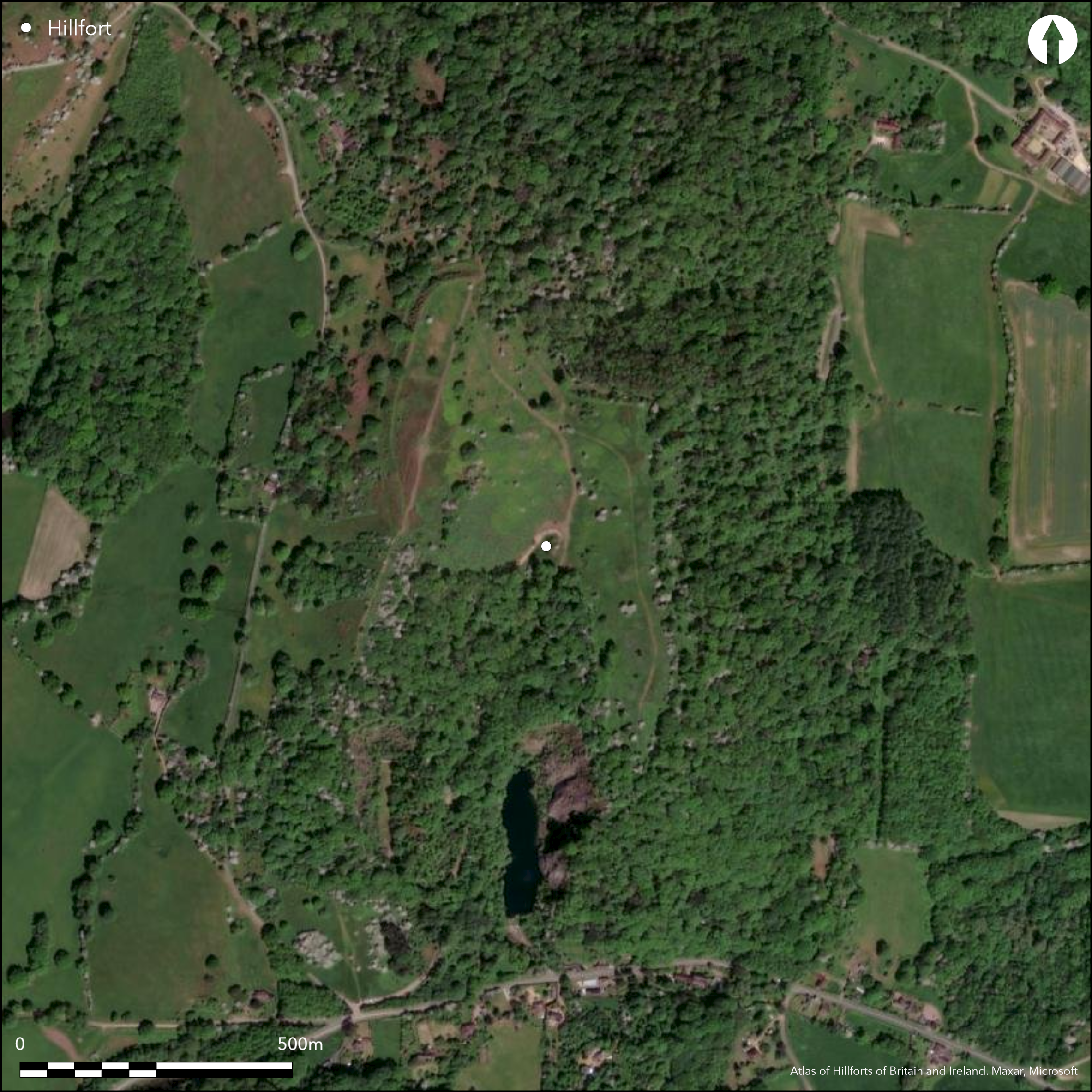
Important, steep and rugged, partial contour hillfort located on two hills with intervening valley, Midsummer Hill and Hollybush Hill, on the ridge of the Malvern Hills S of Herefordshire Beacon and within sight of Worcestershire Beacon. Internal area 7ha. Notable for its numerous (483 recorded) small hut platforms cut into the hillside, suggested by its excavator Stanford (1981) for accommodation. More probably sites of 'four-poster' structures, and a possible site with ritual connotations. A single bank with ditch, the former only c. 1m internally, and a small counterscarp bank. The earthworks are made the more imposing by the ditch being up to 11m below the rampart. There are severe gradients on the circuit. Internal quarry ditch around most of the site, but particularly on Hollybush Hill. The two surviving entrances on the Midsummer Hill are original - to the N an oblique inturned entrance and to the S also inturned and forming a narrow corridor. On Hollybush Hill, to the S, it has been suggested by Lines (not dated) and Hughes (1924), who excavated seven areas, that there was also an entrance, now quarried away. Excavations by Stanford showed 17 phases of construction between 470 BC to AD 30, based on C14 dating, and the, mostly circular, platforms laid out in rows along the contours, their location on steep slopes making them more or less unusable as dwellings, but whether they were all for pure storage is a moot point as stated. The position of the spring between the two hills could be of ritual significance. Recent topographical surveys. Heavily overgrown and wooded in part; open, very rough grazing and bare rock to N. SSSI. General deterioration until management since 2010. Erosion, especially on the N rampart, where the bare rock and rough scrub/grazing. S part of Hollybush Hill to S quarried away. On 1st Ed OS map (1889).
Citizen Science: ✓
Reliability of Data: Confirmed
Reliability of Interpretation: Confirmed
X: -261582 Y: 6806356 (EPSG: 3857)
Longitude: -2.349830741552441 Latitude: 52.03444758825835 (EPSG:4326)
Country: England; None
Current County or Unitary Authority: Herefordshire; Worcestershire
Historic County: Herefordshire; Worcestershire
Current Parish/Community/Council/Townland: Eastnor; Castlemorton
General deterioration until management since 2010. Erosion especially on the N rampart. S part of Hollybush Hill to S quarried away.
| Extant | ✓ |
| Cropmark | ✗ |
| Likely Destroyed | ✗ |
Heavily overgrown and wooded in part; open, very rough grazing and bare rock to N. SSSI.
| Woodland | ✓ |
| Commercial Forestry Plantation | ✗ |
| Parkland | ✗ |
| Pasture (Grazing) | ✗ |
| Arable | ✗ |
| Scrub/Bracken | ✓ |
| Bare Outcrop | ✗ |
| Heather/Moorland | ✗ |
| Heath | ✗ |
| Built-up | ✗ |
| Coastal Grassland | ✗ |
| Other | ✗ |
Partial contour hillfort. Steep slopes are a feature of the site. Because of the topographic nature of the site on two hills, the aspect is very variable. Located on two hills, Midsummer Hill and Hollybush Hill on the ridge of the Malvern Hills. Aspect variable about the large site, predominately NW.
| Contour Fort | ✗ |
| Partial Contour Fort | ✓ |
| Promontory Fort | ✗ |
| Hillslope Fort | ✗ |
| Level Terrain Fort | ✗ |
| Marsh Fort | ✗ |
| Multiple Enclosure Fort | ✗ |
| Hilltop | ✓ |
| Coastal Promontory | ✗ |
| Inland Promontory | ✗ |
| Valley Bottom | ✗ |
| Knoll/Hillock/Outcrop | ✗ |
| Ridge | ✓ |
| Cliff/Plateau-edge/Scarp | ✗ |
| Hillslope | ✗ |
| Lowland | ✗ |
| Spur | ✗ |
Dominant Topographic Feature: The two hilltops of Midsummer Hill to the north and Hollybush Hill to the south with intervening valley.
| North | ✗ |
| Northeast | ✗ |
| East | ✗ |
| Southeast | ✗ |
| South | ✗ |
| Southwest | ✗ |
| West | ✗ |
| Northwest | ✓ |
| Level | ✗ |
Altitude: 286.0m
Boundary Type: County
Dating from two C14 dates taken during Stanford's excavations.
Reliability: B - Medium
| Pre 1200BC | ✗ |
| 1200BC - 800BC | ✗ |
| 800BC - 400BC | ✗ |
| 400BC - AD50 | ✓ |
| AD50 - AD400 | ✗ |
| AD400 - AD 800 | ✗ |
| Post AD800 | ✗ |
| Unknown | ✗ |
| Pre Hillfort: | None |
| Post Hillfort: | None |
| C14: | Dating from two C14 dates taken during Stanford's excavations. |
On 1st Ed OS map (1889). Excavations: Hilton Price 1879; Hughes 1924; Stanford 1965-70. Herefordshire Council survey 2012. English Heritage field survey 1999-2005.
| Excavation (1879): | Excavations by F.G. Hilton Price. |
| 1st Identified Map Depiction (1889): | OS map. |
| Excavation (1924): | Excavations by I.T. Hughes. |
| Other (2012): | Herefordshire Council survey. |
| Excavation (None): | Excavations by S. Stanford. |
| Earthwork Survey (None): | EH Survey (Field). |
A large number of hut platforms recorded during the excavations and as surface features. Pottery and other artefacts from excavations.
Spring/stream at south gate. Spring 0.4km outside the hillfort.
| None | ✗ |
| Spring | ✓ |
| Stream | ✗ |
| Pool | ✗ |
| Flush | ✗ |
| Well | ✗ |
| Other | ✗ |
The large number of hut platforms on the hillside are a feature of the site. Internal quarry ditch around most of the site. Pillow mounds.
| No Known Features | ✗ |
| Round Stone Structures | ✗ |
| Rectangular Stone Structures | ✗ |
| Curvilinear Platforms | ✓ |
| Other Roundhouse Evidence | ✗ |
| Pits | ✗ |
| Quarry Hollows | ✓ |
| Other | ✗ |
The large number of hut platforms recorded during the excavations are a feature of the site.
| No Known Excavation | ✗ |
| Pits | ✗ |
| Postholes | ✗ |
| Roundhouses | ✗ |
| Rectangular Structures | ✓ |
| Roads/Tracks | ✗ |
| Quarry Hollows | ✗ |
| Other | ✗ |
| Nothing Found | ✗ |
Stanford undertook geophysics on the site. Details not determined.
| No Known Geophysics | ✗ |
| Pits | ✗ |
| Roundhouses | ✗ |
| Rectangular Structures | ✗ |
| Roads/Tracks | ✗ |
| Quarry Hollows | ✗ |
| Other | ✓ |
| Nothing Found | ✗ |
Hughes (1924) found linear tooled and stamped Malvernian wares. Stanford (1981) found Malvernian Iron Age ceramics, Droitwich and Cheshire VCP, iron, stone, bronze and bone objects. Evidence of iron and bronze working with iron smelting - furnace lining, ore (from the Forest of Dean) and slag.
| No Known Finds | ✗ |
| Pottery | ✓ |
| Metal | ✓ |
| Metalworking | ✓ |
| Human Bones | ✗ |
| Animal Bones | ✓ |
| Lithics | ✗ |
| Environmental | ✗ |
| Other | ✗ |
None
| APs Not Checked | ✓ |
| None | ✗ |
| Roundhouses | ✗ |
| Rectangular Structures | ✗ |
| Pits | ✗ |
| Postholes | ✗ |
| Roads/Tracks | ✗ |
| Other | ✗ |
The two surviving entrances on the Midsummer Hill are original - to the N an oblique inturned entrance and to the S also inturned and forming a narrow corridor. On Hollybush Hill, to the S, it has been suggested by Lines (not dated) and Hughes (1926) that there was also an entrance, now quarried away.
| 2: | There may be more modern gaps in the rampart. |
| 2: | N gate inturned on E. S gate inturned. |
Guard Chambers: ✓
Chevaux de Frise: ✗
| 1. In-turned (North): | Fine inturned entrance with guard chambers now forms the main access route into the hillfort. |
| 1. Oblique (North): | Oblique entry to site. |
| 2. In-turned (South): | Narrow corridor with fine inturns. |
| 2. Passage-way/Corridor (South): | Narrow corridor. |
A single bank with stone faces, with ditch, the former only c. 1m internally, and a small counterscarp bank. The earthworks are made the more imposing by the ditch being up to 11m below the rampart. There are severe gradients on the circuit.
| Area 1: | 7.0ha. |
| Total: | 7.0ha. |
Total Footprint Area: Noneha.
None
| ✓ | The location on two hills makes the site more complex. Ramparts readily seen. Phased construction. |
| ✓ | The single bank and ditch is a complete circuit apart from where quarried away at the extreme SW part of Hollybush Hill. |
| NE Quadrant: | 1 |
| SE Quadrant: | 1 |
| SW Quadrant: | 1 |
| NW Quadrant: | 1 |
| Total: | 1 |
| Partial Univallate | ✗ |
| Univallate | ✓ |
| Partial Bivallate | ✗ |
| Bivallate | ✗ |
| Partial Multivallate | ✗ |
| Multivallate | ✗ |
| Unknown | ✗ |
| Partial Univallate | ✗ |
| Univallate | ✗ |
| Partial Bivallate | ✗ |
| Bivallate | ✗ |
| Partial Multivallate | ✗ |
| Multivallate | ✗ |
Features readily seen.
| None | ✗ |
| Earthen Bank | ✓ |
| Stone Wall | ✓ |
| Rubble | ✗ |
| Wall-walk | ✗ |
| Evidence of Timber | ✗ |
| Vitrification | ✗ |
| Other Burning | ✗ |
| Palisade | ✗ |
| Counter Scarp Bank | ✓ |
| Berm | ✗ |
| Unfinished | ✗ |
| Other | ✗ |
None
| None | ✗ |
| Earthen Bank | ✓ |
| Stone Wall | ✓ |
| Murus Duplex | ✗ |
| Timber-framed | ✗ |
| Timber-laced | ✗ |
| Vitrification | ✗ |
| Other Burning | ✗ |
| Palisade | ✗ |
| Counter Scarp Bank | ✓ |
| Berm | ✗ |
| Unfinished | ✗ |
| No Known Excavation | ✗ |
| Other | ✗ |
| ✗ | None |
| ✓ | Ditch up to 11m below the rampart |
Number of Ditches: 1
| ✗ | None |
Bowden, M. 2005. The Malvern Hills an ancient landscape, London: English Heritage.
Brown, I. 2009. Beacons in the landscape. the hillforts of England and Wales, Oxford: Windgather Press/Oxbow Books.
Dorling, P. and Wigley, A. 2012. Assessment of the archaeological and conservation status of major later prehistoric enclosures in Herefordshire and Shropshire, EH PNUM, Version 3.2, Hereford and Shrewsbury: Herefordshire Council/Shropshire Council.
Hilton Price, F.G. 1887. Camps on the Malvern Hills, Trans Woolhope Natur Fld Club, 9 (1877-80), 217-28.
Hughes, I.T 1924: Report on the excavations conducted on Midsummer Hill, Trans Woolhope Natur Fld Club, 1924, 18-27.
Stanford, S.C. 1981. Midsummer Hill, Leominster: Privately published.
Atlas of Hillforts:
Wikidata:
This work is licensed under CC BY-SA 4.0![]()
![]()
![]() and should be cited as:
and should be cited as:
Lock, Gary and Ralston, Ian. 2024. Atlas of Hillforts of Britain and Ireland. Available at: https://hillforts.arch.ox.ac.uk
Document Version 1.1