LiDAR 1m DTM Hillshade
Satellite Imagery
LiDAR 1m DTM Hillshade
Satellite Imagery
Scroll left/right to view further images.
HER: Herefordshire MHE906 (2221)
NMR: SO 55 NW 2 (110662)
SM: 1001749
NGR: SO 542553
X: 354200 Y: 255300 (OSGB36)
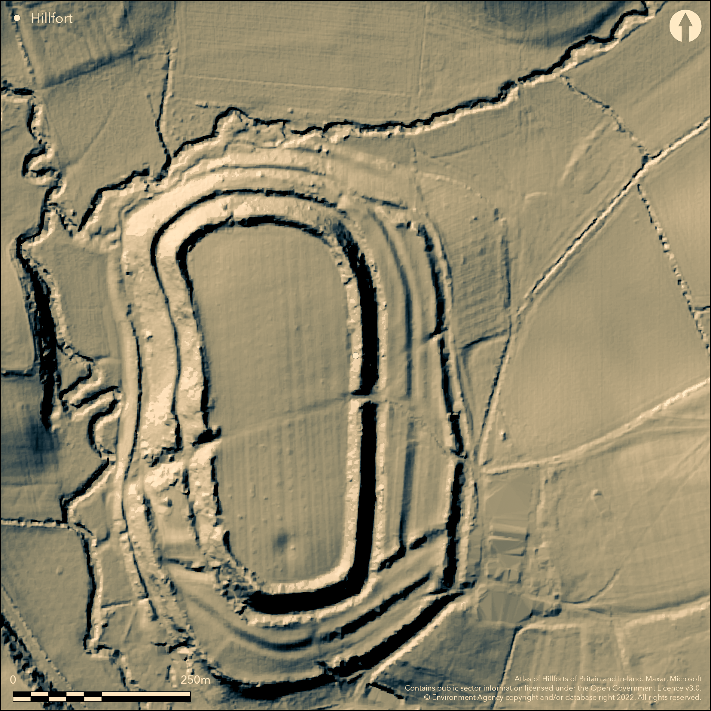
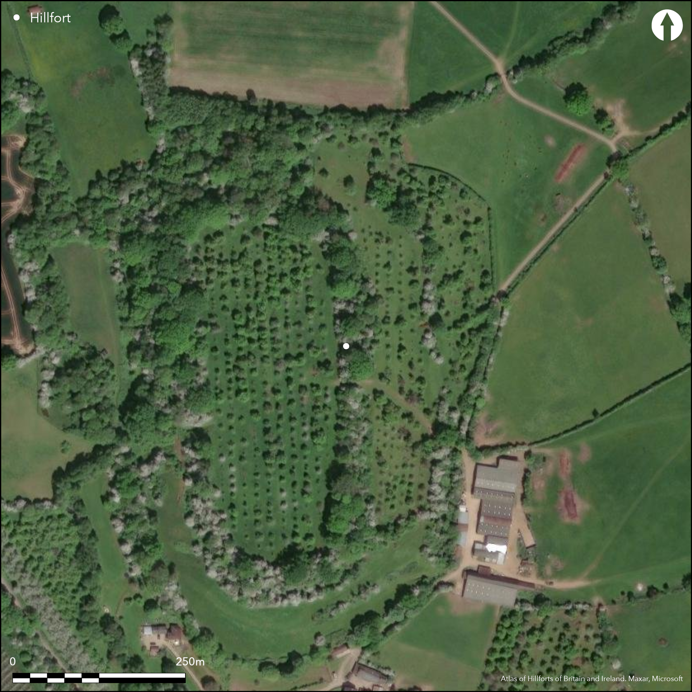
Large, multivallate, contour hillfort located on a small flat-topped knoll on very moderate slopes at the confluence of Holly and Humber Brooks and above the confluence of the Rivers Lugg and Arrow. Internal area 3.4ha and footprint 11.3ha. Widely-spaced ramparts on the E side may be later cultivation terraces or lynchets. On the W the rampart is a dry-built stone wall faced externally. Roman pottery found. The site is in fairly good condition and has been cultivated as an orchard for many years. Now part of management agreements which should assist in the preservation of the site and alleviate problems. Undated. On 1st Ed OS map 1886.
Citizen Science: ✗
Reliability of Data: Confirmed
Reliability of Interpretation: Confirmed
X: -297387 Y: 6835278 (EPSG: 3857)
Longitude: -2.671475921968273 Latitude: 52.19398998608534 (EPSG:4326)
Country: England
Current County or Unitary Authority: Herefordshire
Historic County: Herefordshire
Current Parish/Community/Council/Townland: Humber
In fairly good condition despite the trees. Now part of management agreements which should assist in the preservation of the site and alleviate problems.
| Extant | ✓ |
| Cropmark | ✗ |
| Likely Destroyed | ✗ |
Wooded ramparts. The interior is part orchard and has been so for many years.
| Woodland | ✓ |
| Commercial Forestry Plantation | ✗ |
| Parkland | ✗ |
| Pasture (Grazing) | ✓ |
| Arable | ✗ |
| Scrub/Bracken | ✗ |
| Bare Outcrop | ✗ |
| Heather/Moorland | ✗ |
| Heath | ✗ |
| Built-up | ✗ |
| Coastal Grassland | ✗ |
| Other | ✓ |
Site follows the contours. Located at the confluence of Holly and Humber Brooks.
| Contour Fort | ✓ |
| Partial Contour Fort | ✗ |
| Promontory Fort | ✗ |
| Hillslope Fort | ✗ |
| Level Terrain Fort | ✗ |
| Marsh Fort | ✗ |
| Multiple Enclosure Fort | ✗ |
| Hilltop | ✗ |
| Coastal Promontory | ✗ |
| Inland Promontory | ✗ |
| Valley Bottom | ✓ |
| Knoll/Hillock/Outcrop | ✗ |
| Ridge | ✗ |
| Cliff/Plateau-edge/Scarp | ✗ |
| Hillslope | ✗ |
| Lowland | ✗ |
| Spur | ✗ |
Dominant Topographic Feature: Interesting location on the edge of Holly Brook on small flat-topped knoll, possibly artificially levelled.
| North | ✗ |
| Northeast | ✗ |
| East | ✗ |
| Southeast | ✗ |
| South | ✗ |
| Southwest | ✗ |
| West | ✗ |
| Northwest | ✗ |
| Level | ✓ |
Altitude: 120.0m
N/A
None
Reliability: D - None
| Pre 1200BC | ✗ |
| 1200BC - 800BC | ✗ |
| 800BC - 400BC | ✗ |
| 400BC - AD50 | ✗ |
| AD50 - AD400 | ✗ |
| AD400 - AD 800 | ✗ |
| Post AD800 | ✗ |
| Unknown | ✓ |
| Pre Hillfort: | None |
| Post Hillfort: | Roman pottery found. |
On 1st Ed OS map 1886. Herefordshire Council survey 2012.
| 1st Identified Map Depiction (1886): | OS map. |
| Other (1968): | Visit by Hillfort Study Group |
| Other (2012): | Herefordshire Council survey. |
Roman pottery.
Located on the edge of Holly Brook.
| None | ✓ |
| Spring | ✗ |
| Stream | ✗ |
| Pool | ✗ |
| Flush | ✗ |
| Well | ✗ |
| Other | ✗ |
None
| No Known Features | ✓ |
| Round Stone Structures | ✗ |
| Rectangular Stone Structures | ✗ |
| Curvilinear Platforms | ✗ |
| Other Roundhouse Evidence | ✗ |
| Pits | ✗ |
| Quarry Hollows | ✗ |
| Other | ✗ |
None
| No Known Excavation | ✓ |
| Pits | ✗ |
| Postholes | ✗ |
| Roundhouses | ✗ |
| Rectangular Structures | ✗ |
| Roads/Tracks | ✗ |
| Quarry Hollows | ✗ |
| Other | ✗ |
| Nothing Found | ✗ |
None
| No Known Geophysics | ✓ |
| Pits | ✗ |
| Roundhouses | ✗ |
| Rectangular Structures | ✗ |
| Roads/Tracks | ✗ |
| Quarry Hollows | ✗ |
| Other | ✗ |
| Nothing Found | ✗ |
Roman pottery.
| No Known Finds | ✗ |
| Pottery | ✓ |
| Metal | ✗ |
| Metalworking | ✗ |
| Human Bones | ✗ |
| Animal Bones | ✗ |
| Lithics | ✗ |
| Environmental | ✗ |
| Other | ✗ |
None
| APs Not Checked | ✓ |
| None | ✗ |
| Roundhouses | ✗ |
| Rectangular Structures | ✗ |
| Pits | ✗ |
| Postholes | ✗ |
| Roads/Tracks | ✗ |
| Other | ✗ |
Two entrances, one original on the W side, slightly inturned and with a protected approach.
| 2: | E entrance possibly modern. |
| 2: | W entrance probably original. |
Guard Chambers: ✗
Chevaux de Frise: ✗
| 1. In-turned (West): | Slight inturned and protected approach on the W side. |
Widely-spaced ramparts on the E side may be later cultivation terraces or lynchets. On the W the rampart is a dry-built stone wall faced externally - could be conjecture here.
| Area 1: | 3.4ha. |
| Total: | 3.4ha. |
Total Footprint Area: 11.3ha.
None
| ✗ | Widely spaced ramparts. |
| ✓ | Widely-spaced ramparts on E side may be problematical. |
| NE Quadrant: | 3 |
| SE Quadrant: | 3 |
| SW Quadrant: | 2 |
| NW Quadrant: | 2 |
| Total: | 3 |
| Partial Univallate | ✗ |
| Univallate | ✗ |
| Partial Bivallate | ✓ |
| Bivallate | ✗ |
| Partial Multivallate | ✓ |
| Multivallate | ✗ |
| Unknown | ✗ |
| Partial Univallate | ✗ |
| Univallate | ✗ |
| Partial Bivallate | ✗ |
| Bivallate | ✗ |
| Partial Multivallate | ✗ |
| Multivallate | ✗ |
On W the rampart is a dry-built stone wall faced externally.
| None | ✗ |
| Earthen Bank | ✗ |
| Stone Wall | ✓ |
| Rubble | ✗ |
| Wall-walk | ✗ |
| Evidence of Timber | ✗ |
| Vitrification | ✗ |
| Other Burning | ✗ |
| Palisade | ✗ |
| Counter Scarp Bank | ✗ |
| Berm | ✗ |
| Unfinished | ✗ |
| Other | ✗ |
None
| None | ✗ |
| Earthen Bank | ✗ |
| Stone Wall | ✗ |
| Murus Duplex | ✗ |
| Timber-framed | ✗ |
| Timber-laced | ✗ |
| Vitrification | ✗ |
| Other Burning | ✗ |
| Palisade | ✗ |
| Counter Scarp Bank | ✗ |
| Berm | ✗ |
| Unfinished | ✗ |
| No Known Excavation | ✓ |
| Other | ✗ |
| ✗ | None |
| ✗ | There appears to be no ditches visible. |
Number of Ditches: 0
| ✗ | None |
Dorling, P. and Wigley, A. 2012. Assessment of the archaeological and conservation status of major later prehistoric enclosures in Herefordshire and Shropshire, EH PNUM, Version 3.2, Hereford and Shrewsbury: Herefordshire Council/Shropshire Council.
Page, W. ed. 1908. The Victoria County History of the County of Herefordshire, 1, 213-14, London: St Catherine Press.
RCHME 1931-34. An Inventory of the Historical Monuments in Herefordshire, 3, (NW), 73-4, 8, London: HMSO.
Atlas of Hillforts:
Wikidata:
This work is licensed under CC BY-SA 4.0![]()
![]()
![]() and should be cited as:
and should be cited as:
Lock, Gary and Ralston, Ian. 2024. Atlas of Hillforts of Britain and Ireland. Available at: https://hillforts.arch.ox.ac.uk
Document Version 1.1